WD7 8JX - 3 bedroom terraced house for sale in Station Road, Radlett,…
View on Property Piper
3 bedroom terraced house for sale in Station Road, Radlett, Hertfordshire, WD7
Property Details
- Price: £650000
- Bedrooms: 3
- Bathrooms: 2
- Property Type: undefined
- Property SubType: undefined
Brochure Descriptions
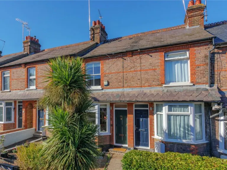
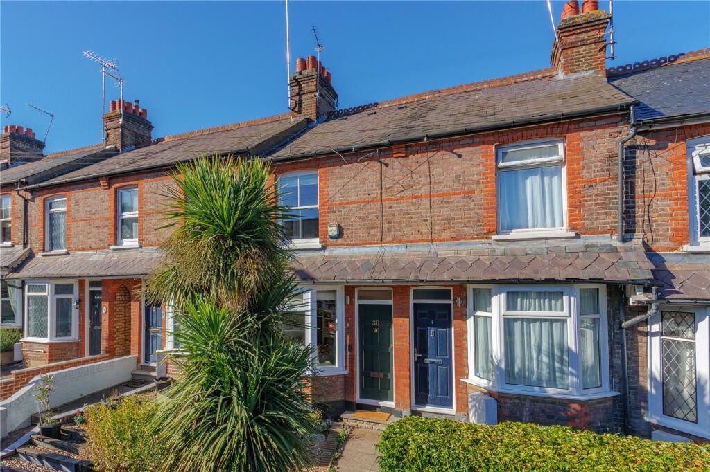
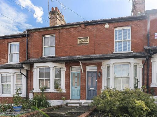
- Listing header indicates a property for sale on Station Road in Radlett (WD7 8JX). No house number or name is shown. Based solely on the listing cover there are no internal or external photographs to describe; therefore room layout, finish, number of bedrooms and exact plot size cannot be determined. As a valuator-style summary: the property sits on Station Road in Radlett — a desirable Hertfordshire commuter location with strong appeal to buyers seeking good rail links to London and established local amenities. The address suggests a residential urban/suburban context; likely attracts family and professional buyers. Further valuation would require photographs, floorplans, tenure information and gross internal area to assess condition, living space and market value accurately.
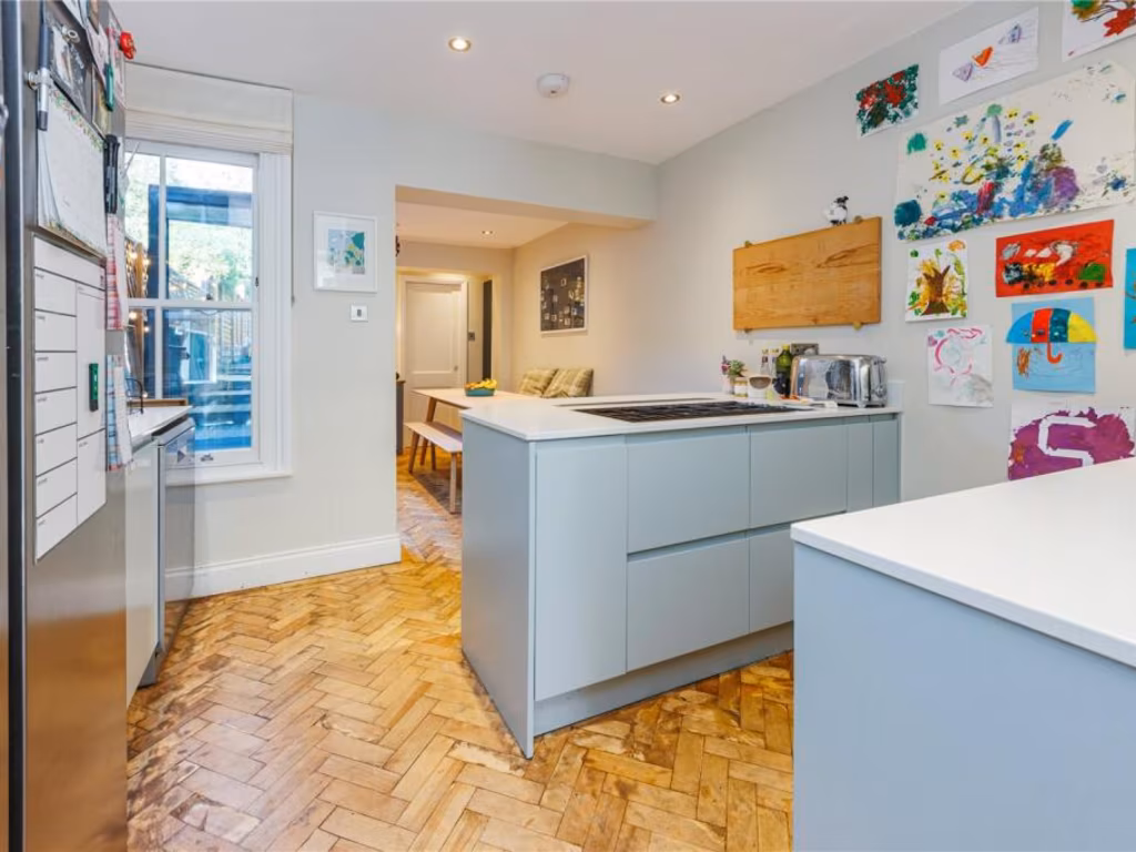
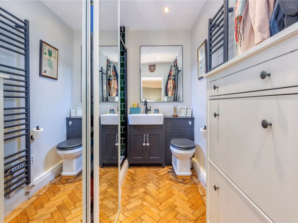
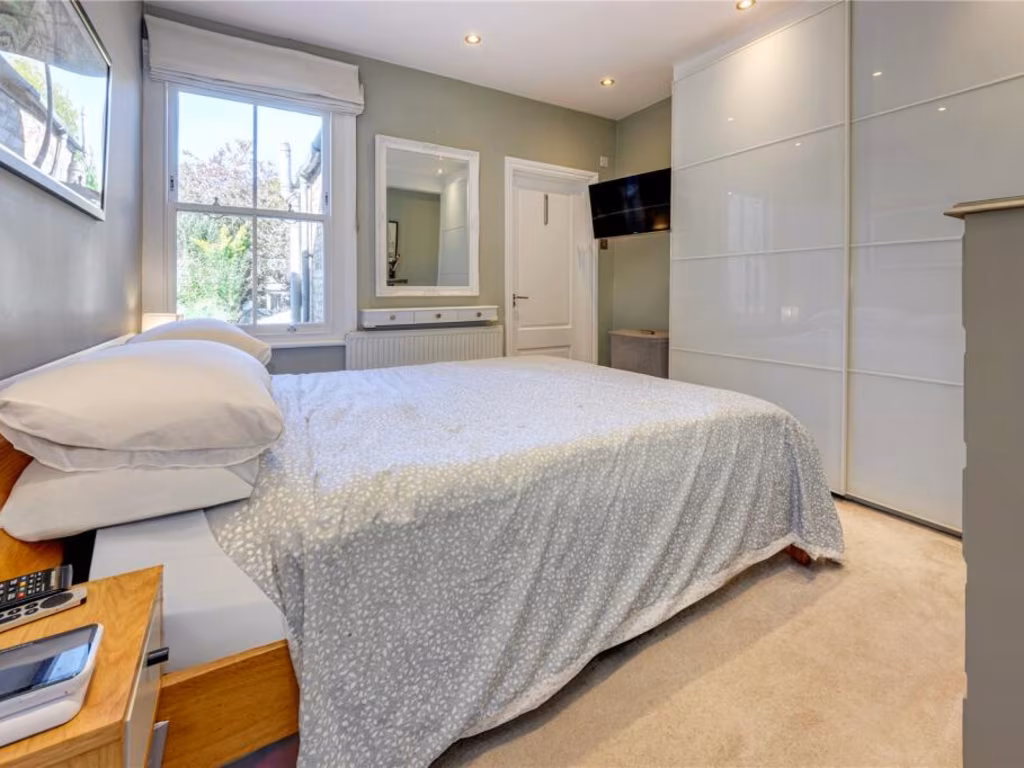
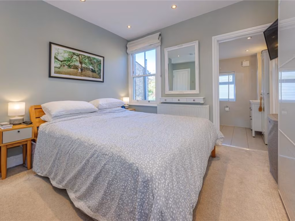
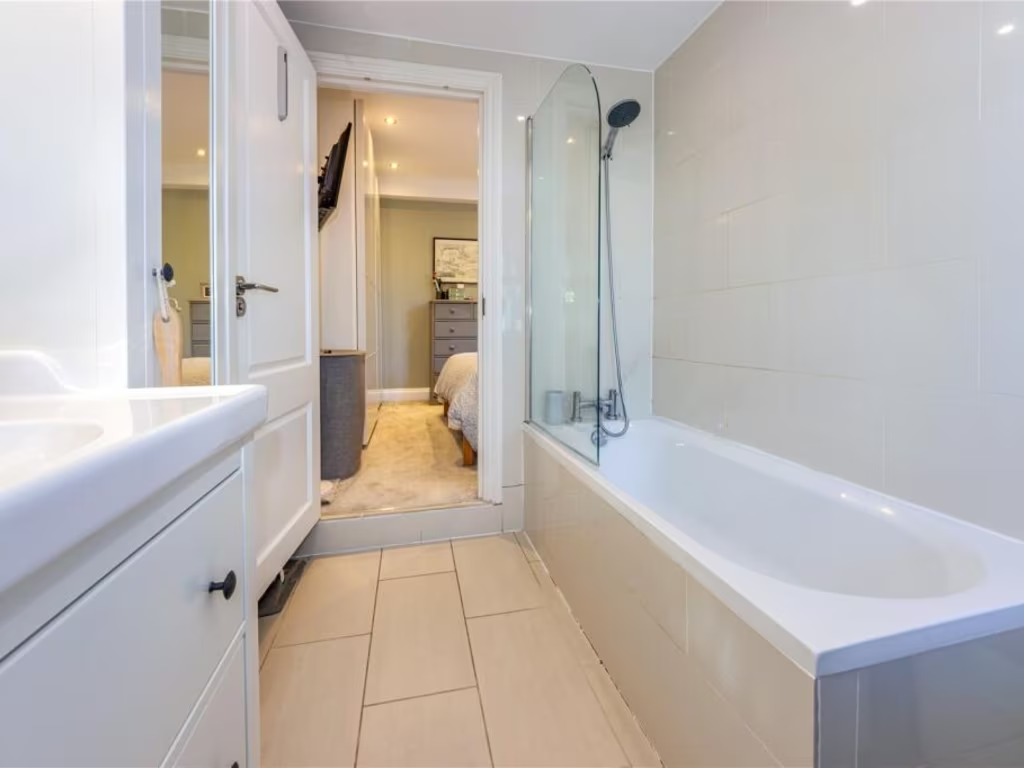
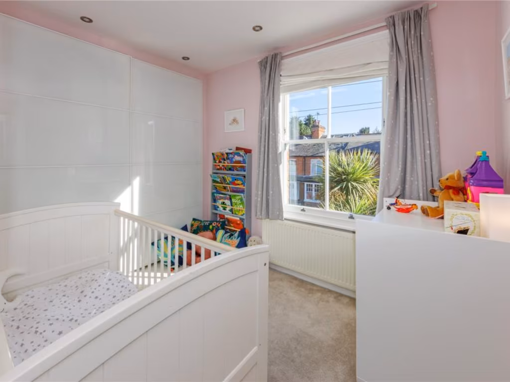
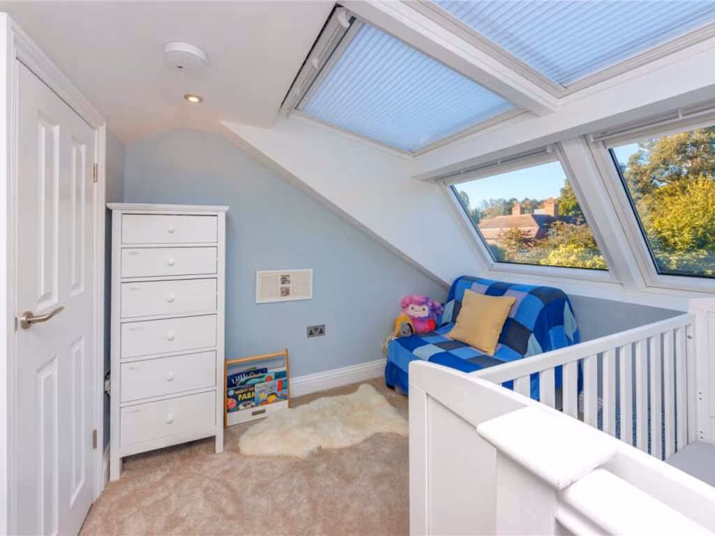
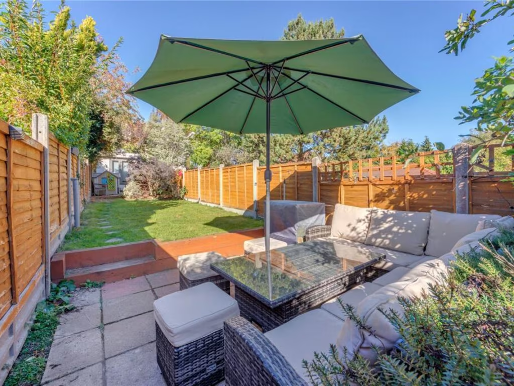
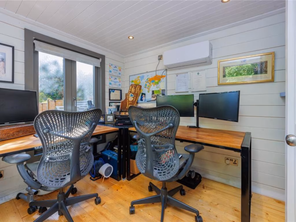
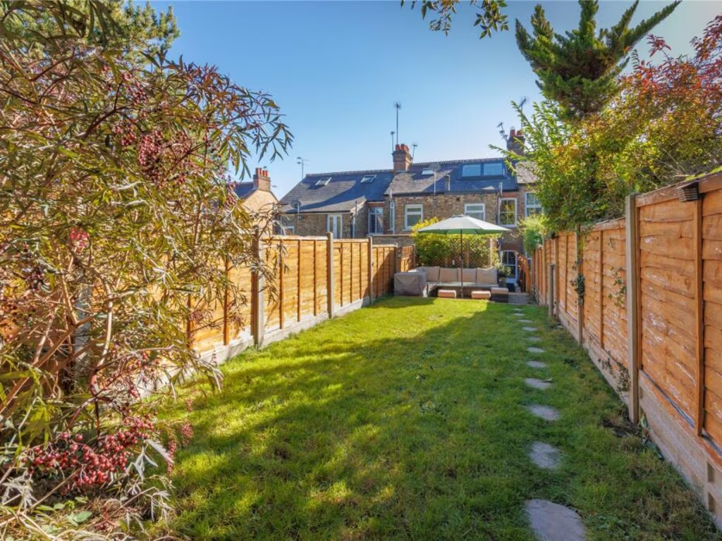
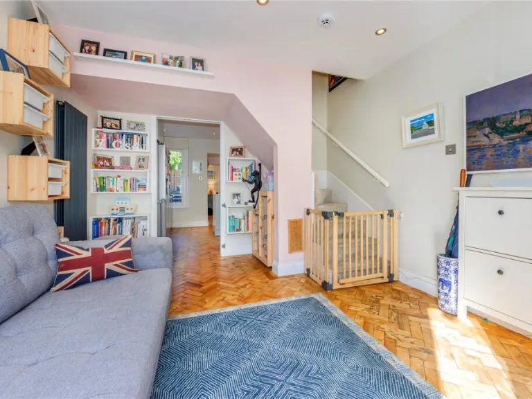
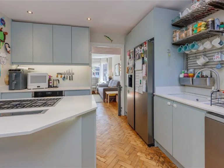
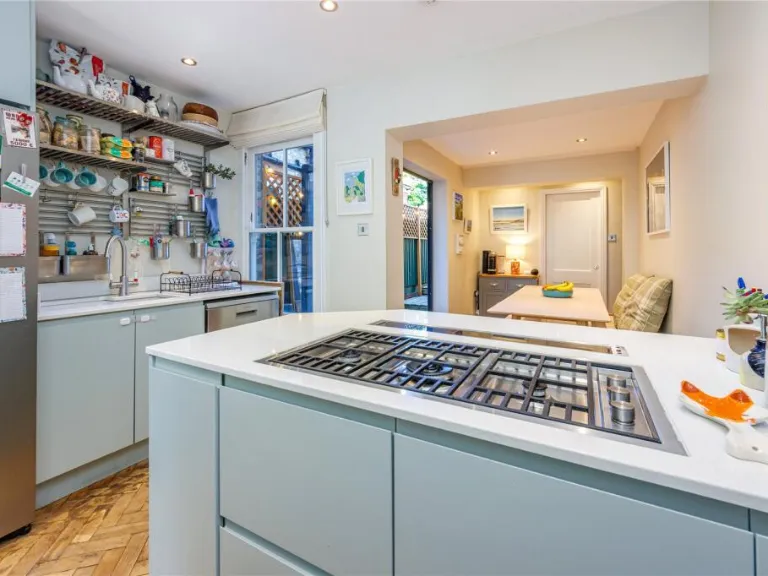
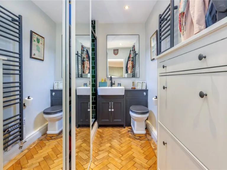
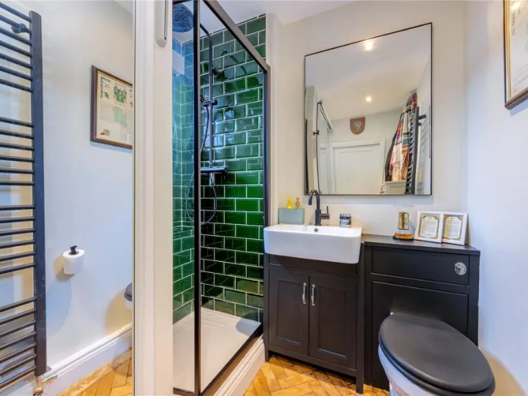
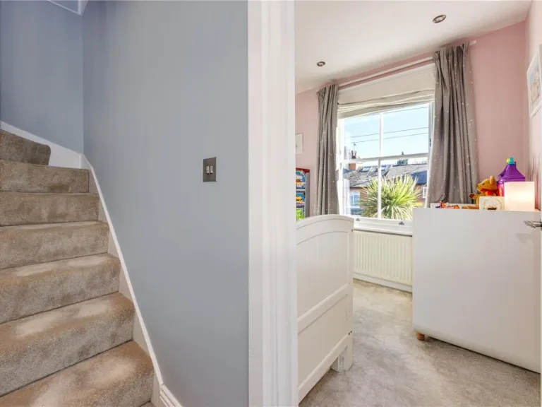
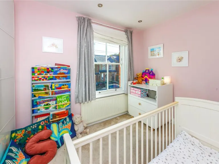
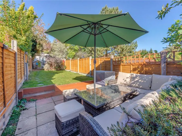
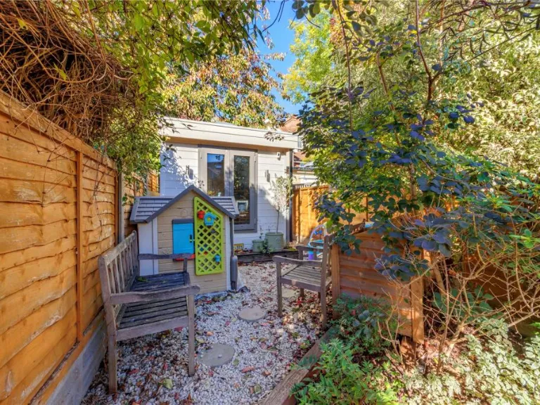
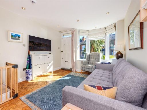
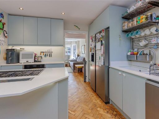
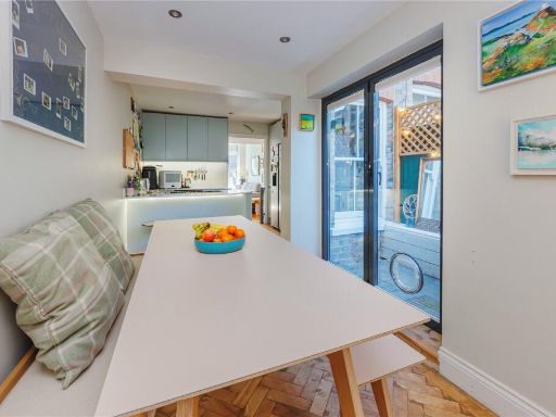
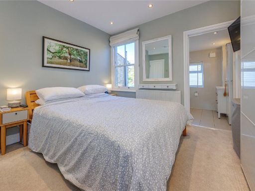
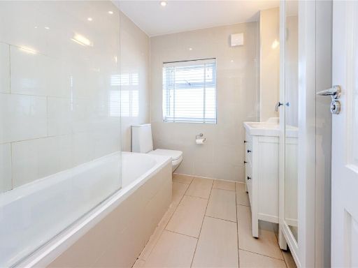
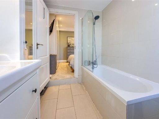
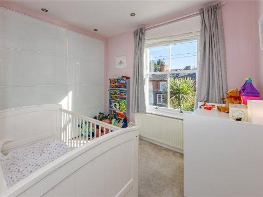
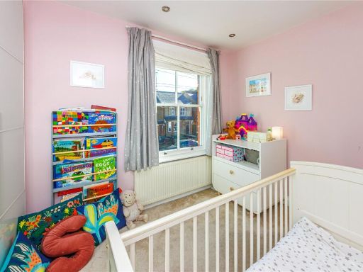
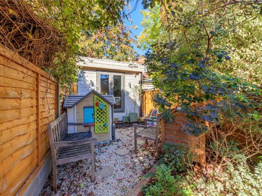
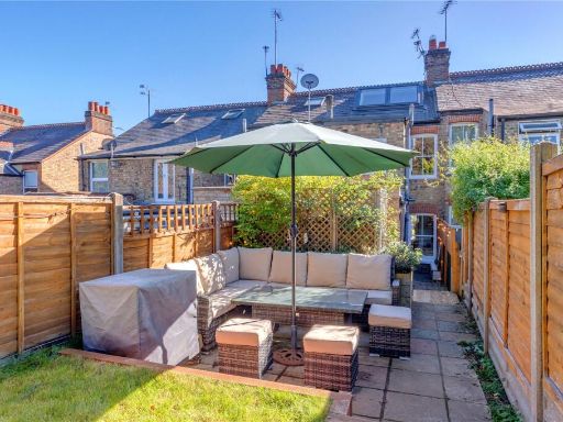
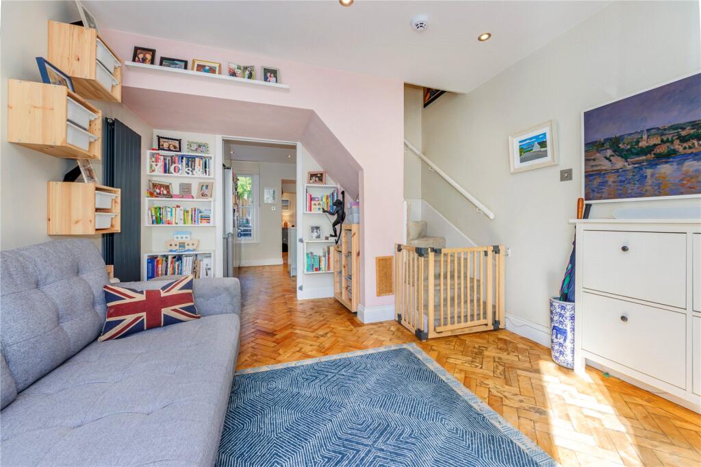
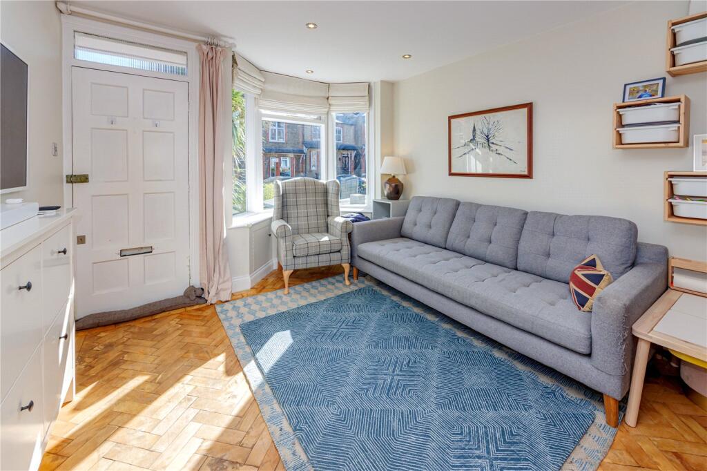
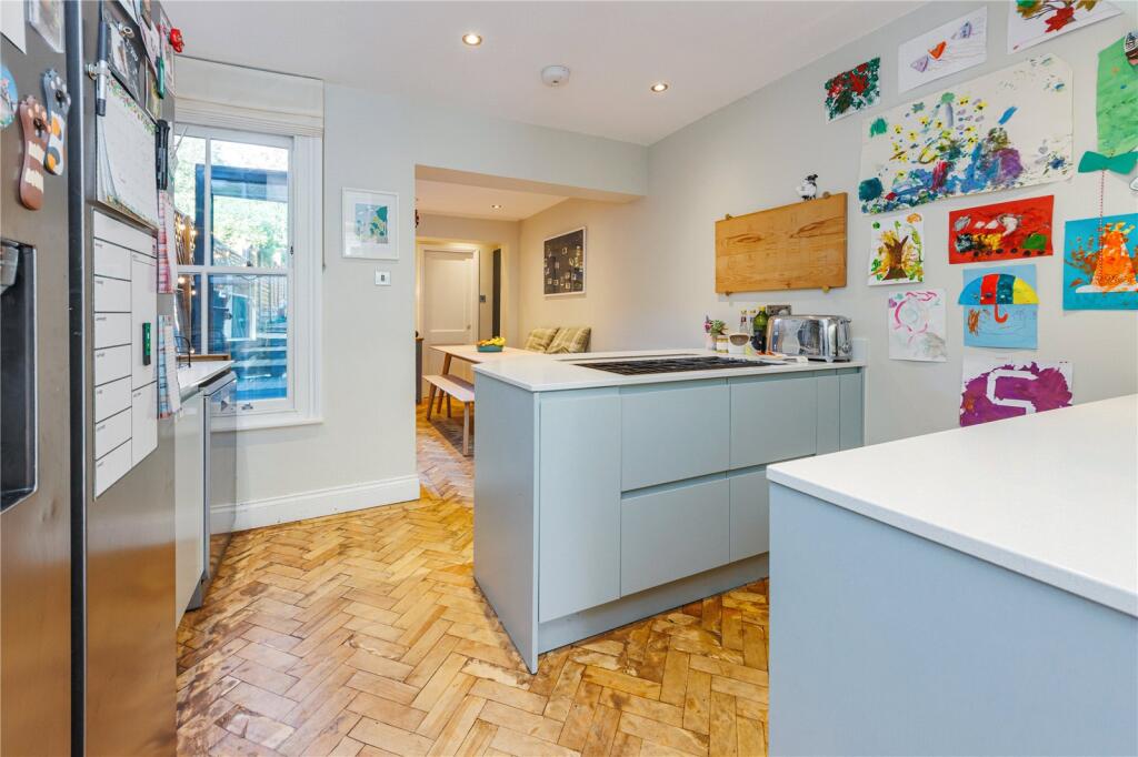
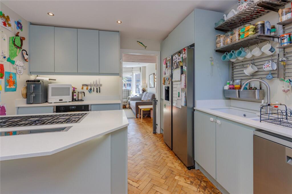
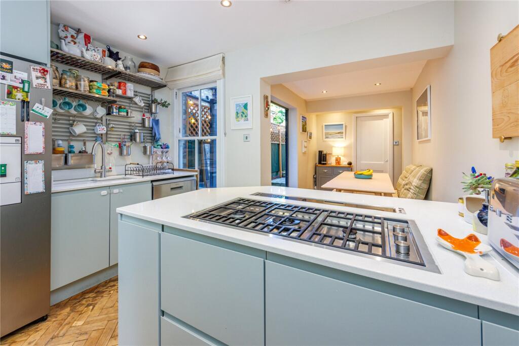
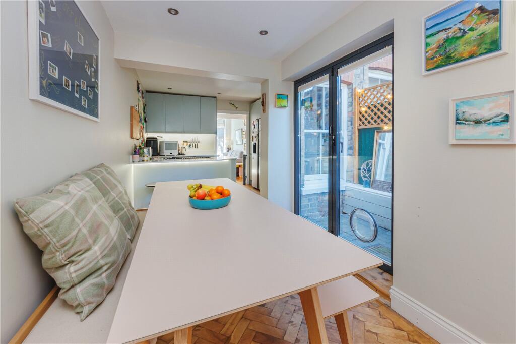
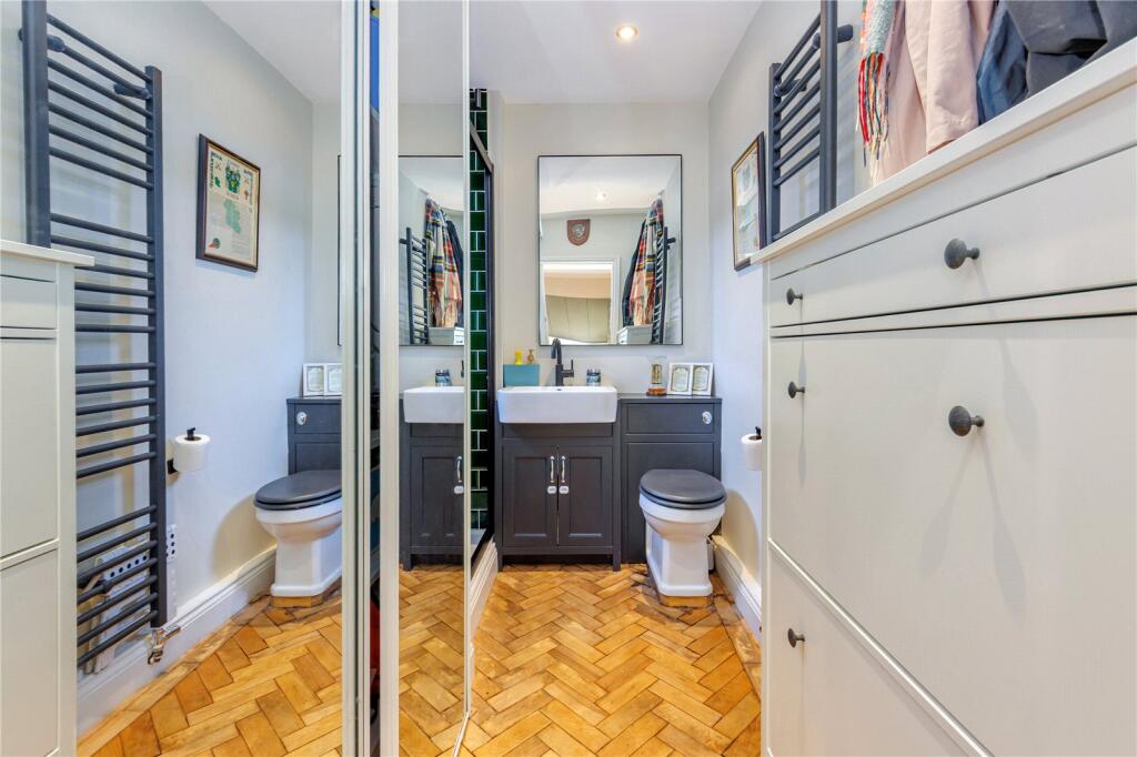
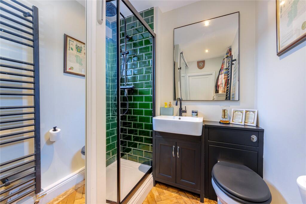
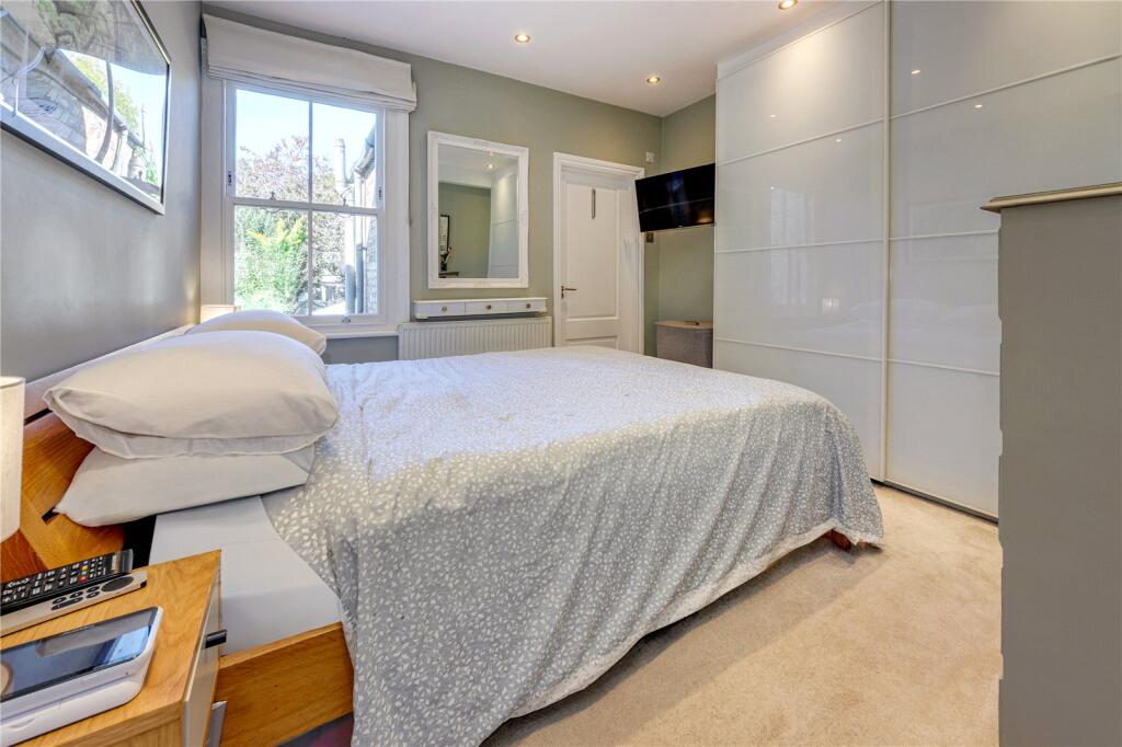
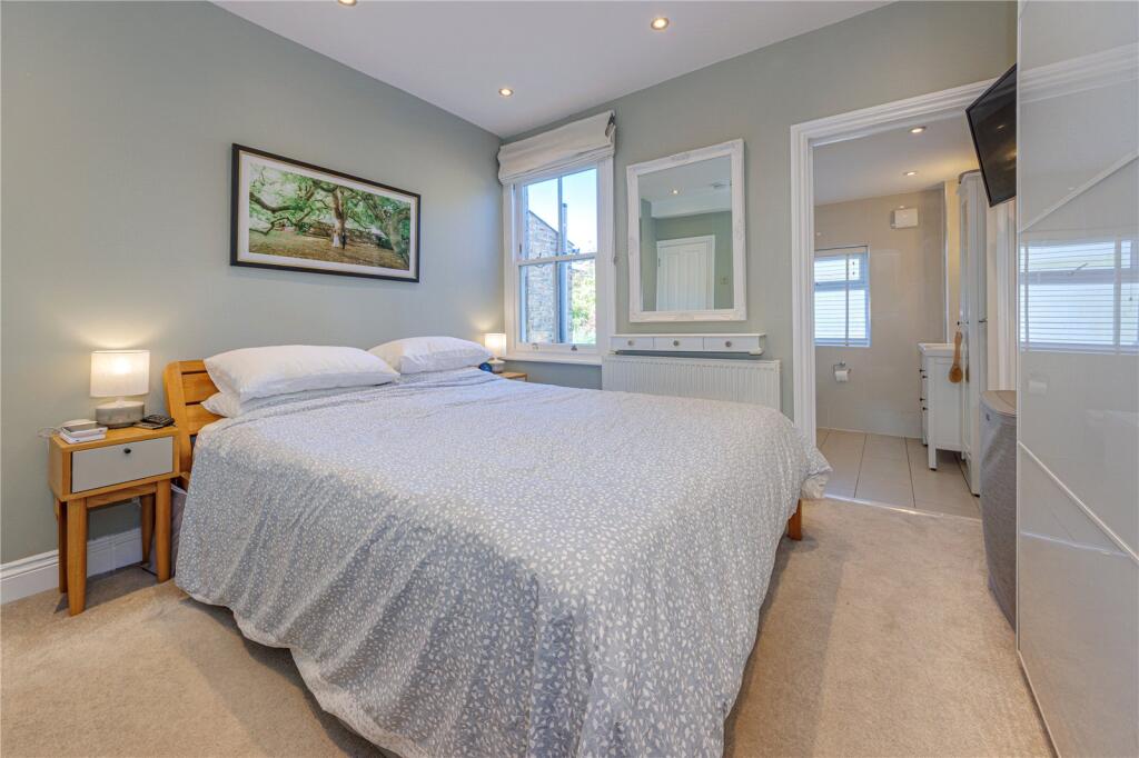
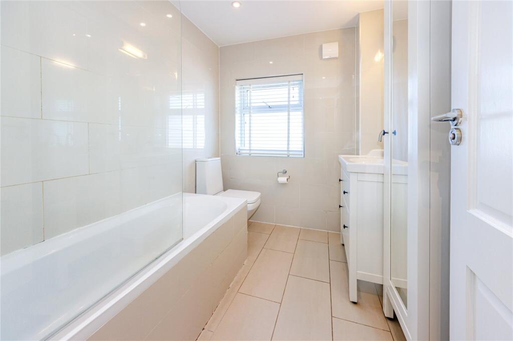
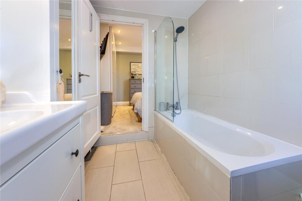
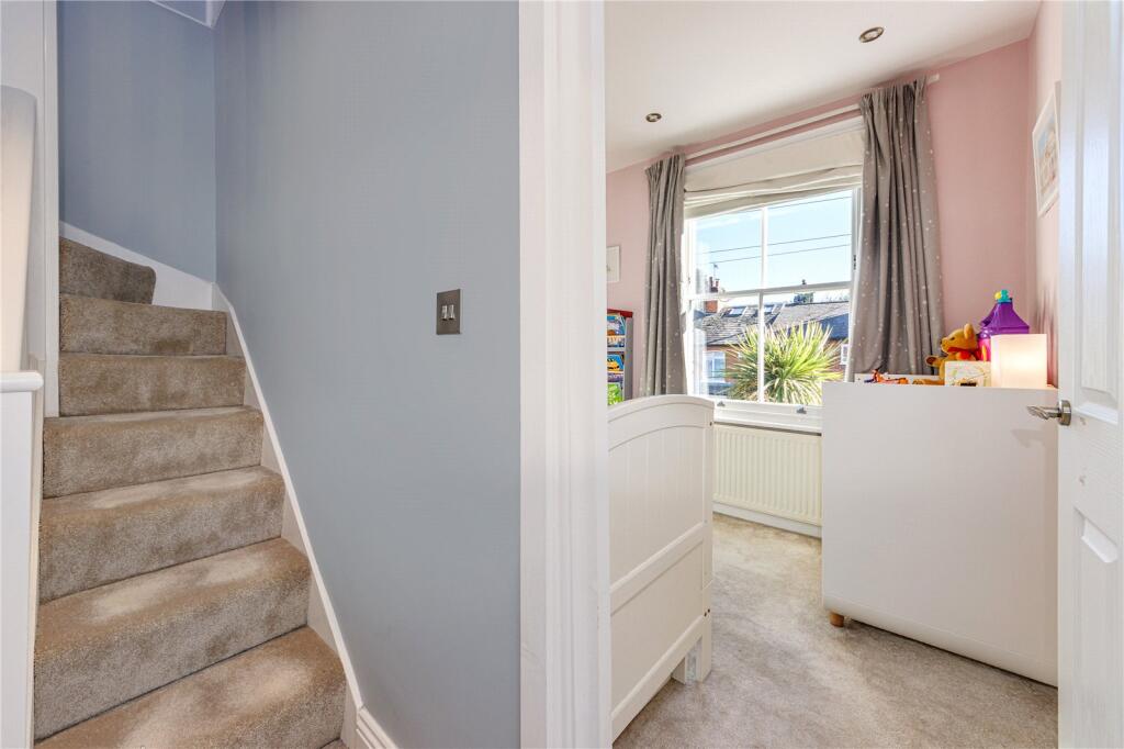
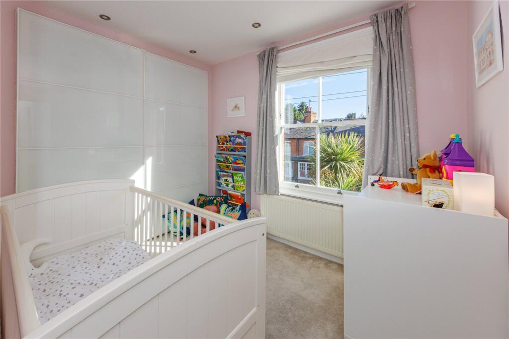
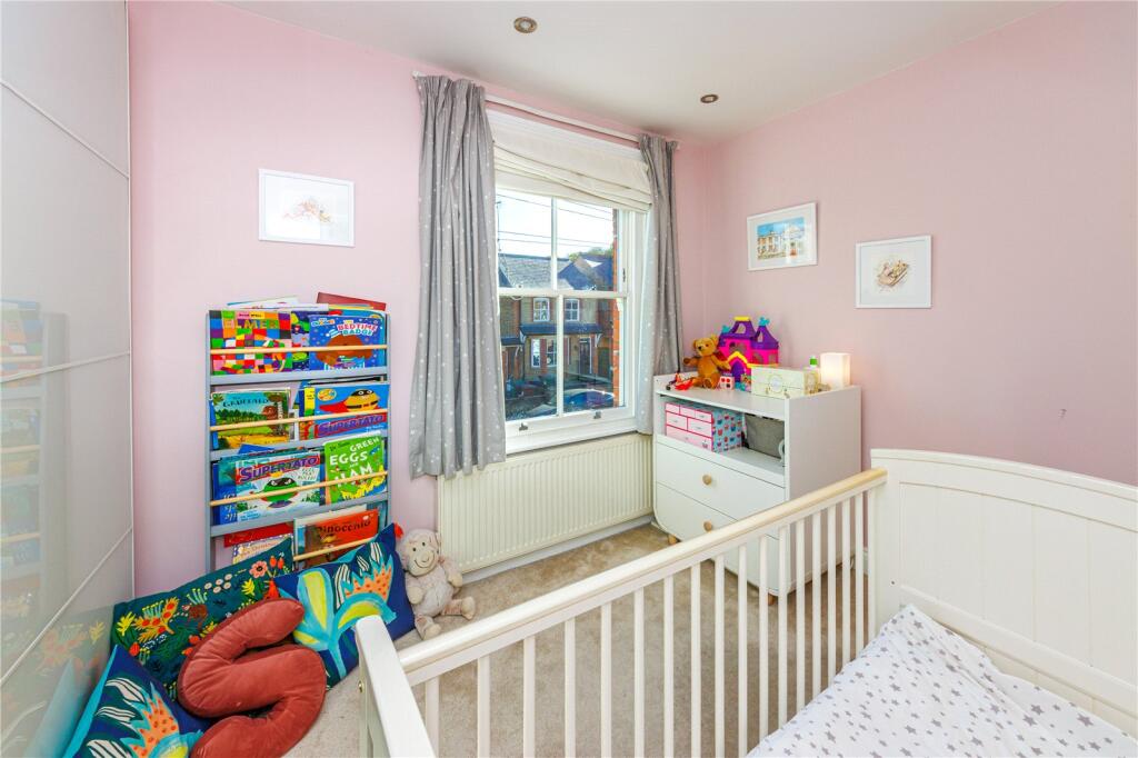
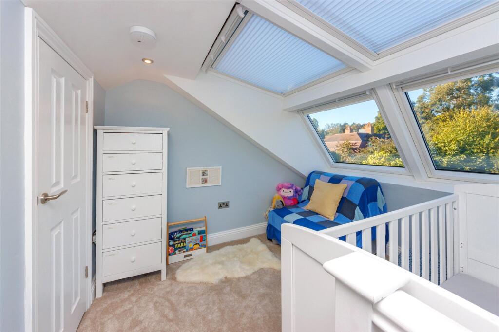
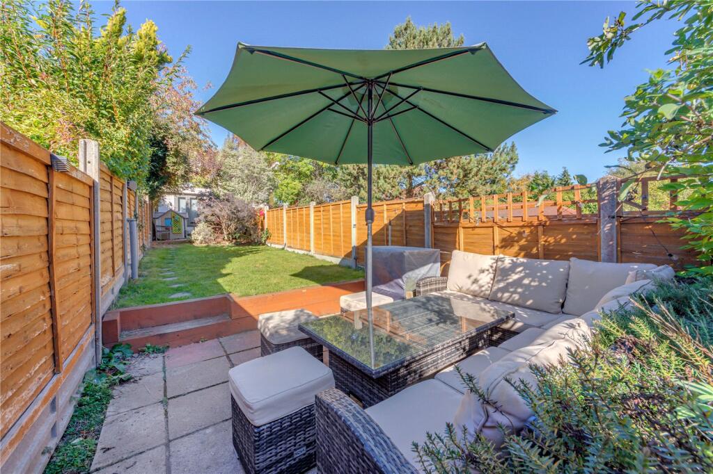
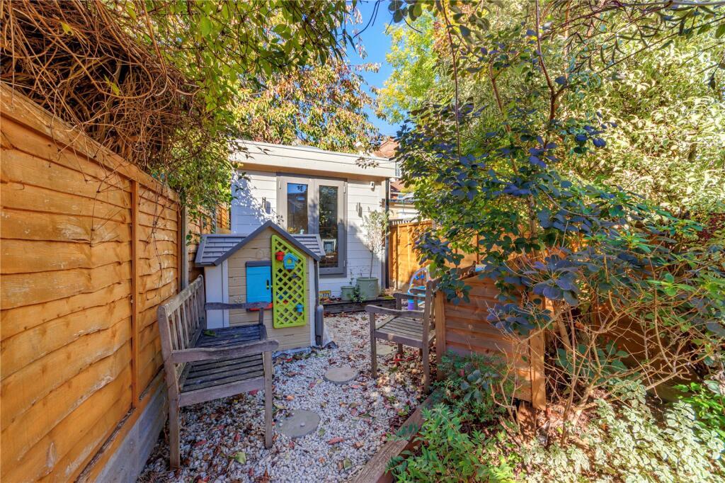
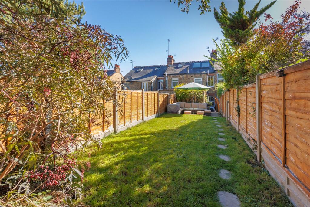
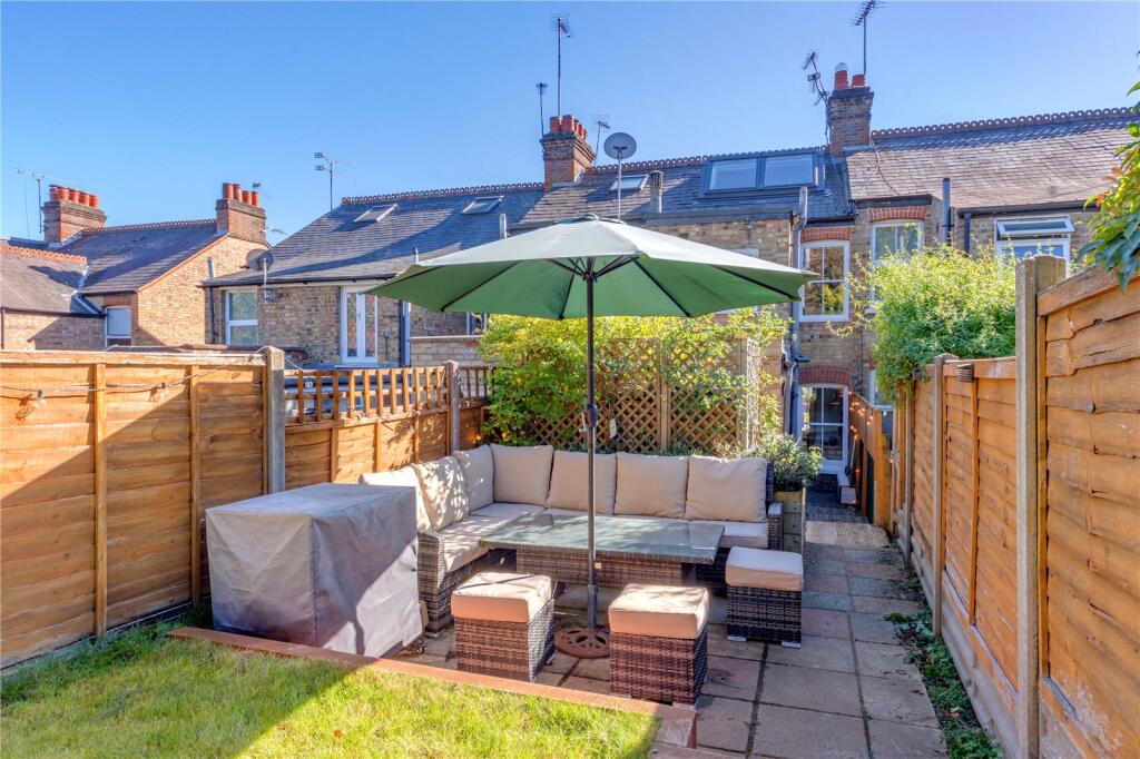
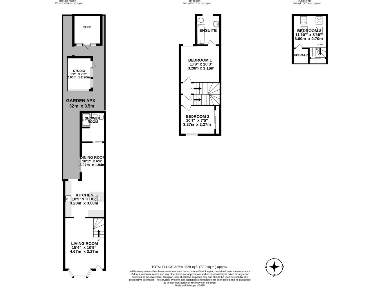
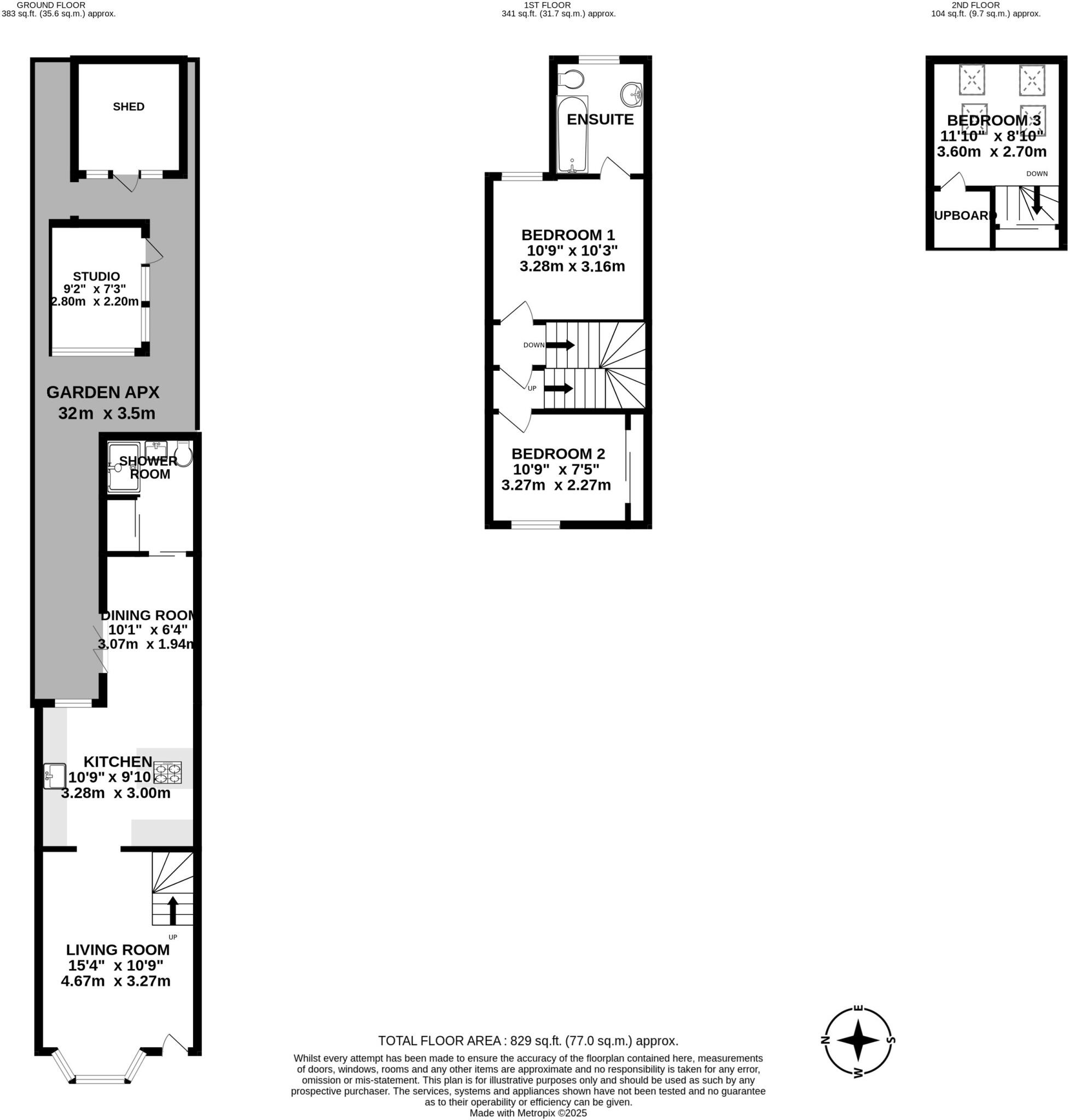
- Long, narrow terraced house arranged over ground, first and loft levels with a substantial long rear garden and outbuildings. Ground floor: front living room, fitted kitchen, dining room and rear shower room. Garden approx 32.0m x 3.5m with a garden studio and separate shed. First floor: two bedrooms (one with ensuite). Loft/second-floor level: additional small bedroom. Overall accommodation is compact and linear in plan, typical of a Victorian terraced footprint. Internal rooms are small-to-average in size; the garden is long and of above-average depth for an urban property, providing significant external amenity and potential for extension or improvement subject to planning. The layout suits a small family or investor refurb opportunity; scope to remodel internal space to open-plan kitchen/dining and reconfigure the outbuildings. No explicit street address or exact square footage is legible on the provided image.
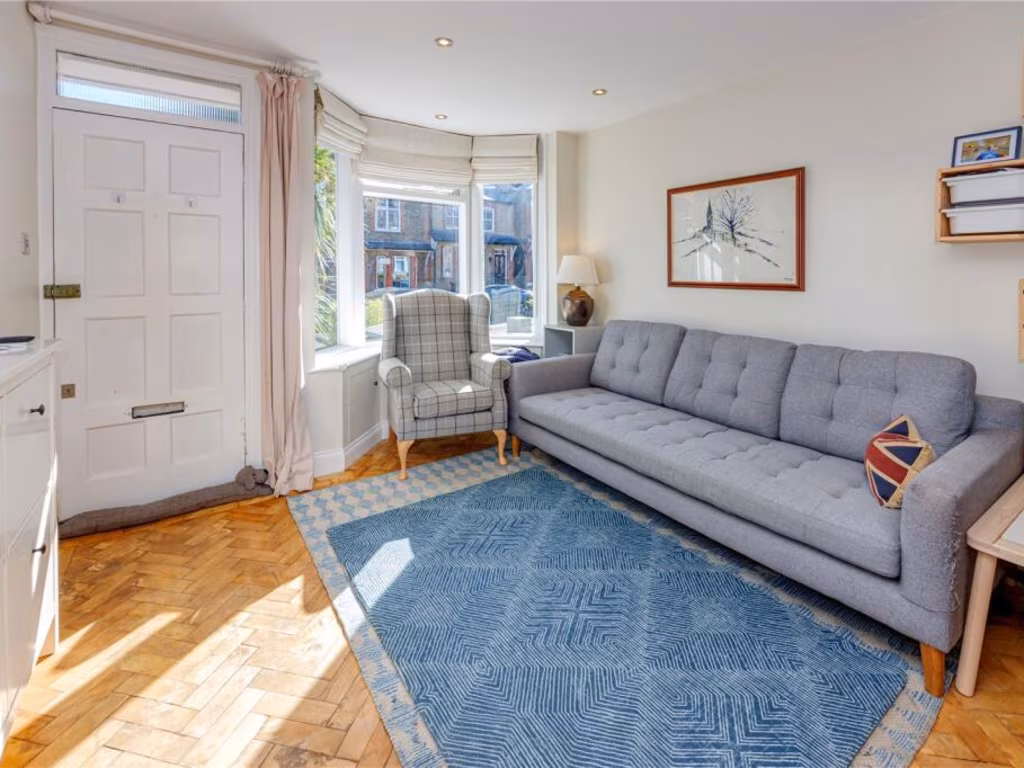
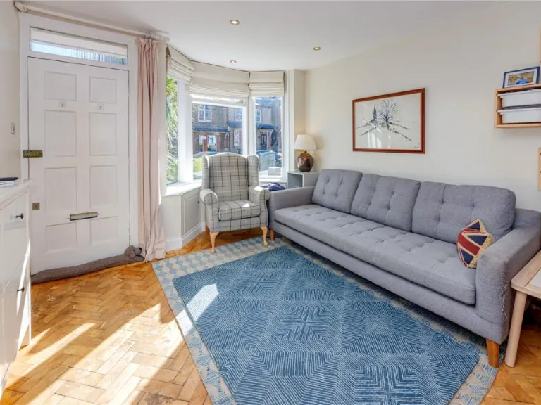
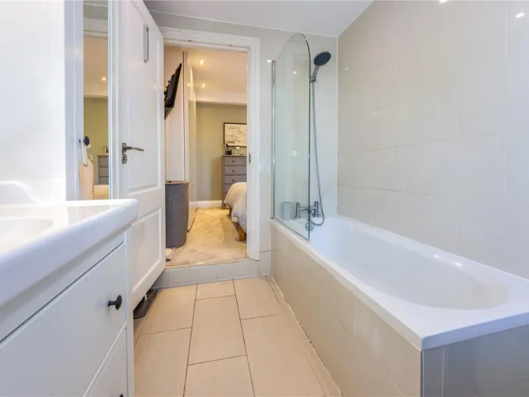
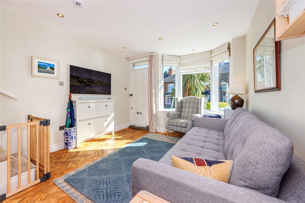
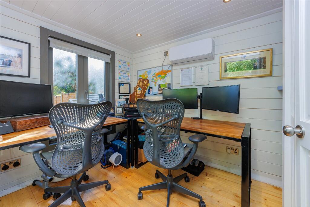
- Three-bedroom period/modern hybrid residence on Station Road in Radlett. The property appears to be in excellent decorative condition throughout with a well-planned contemporary layout. Ground floor: welcoming living room with bay window, dining area with folding doors to the rear garden, fitted kitchen with premium appliances and a convenient shower room/WC that doubles as a utility. Upper floors: principal bedroom with ensuite and garden views, a second generously sized bedroom with built-in storage, and a third bedroom on the top floor with large feature windows. Externally the plot is notable for a long rear garden extending over 30m, a spacious seating lawn, a fully insulated garden room/office with power and heating, and a large rear shed for additional storage. Location offers strong commuter appeal (under 5 minutes’ walk to Radlett Station with direct services to central London under 30 minutes) and proximity to local high street amenities. Overall property size: medium (family home); garden: large and well-maintained.
Image Descriptions
- front exterior Victorian
- living room modern
Floorplan Description
- Three‑storey terraced property with living, kitchen, dining and three bedrooms (plus external studio and shed).
Rooms
- LIVING ROOM: large
- KITCHEN: average
- DINING ROOM: small
- SHOWER ROOM: unknown
- STUDIO: small (external)
- SHED: unknown (external)
- BEDROOM 1: average
- ENSUITE: unknown
- BEDROOM 2: average
- BEDROOM 3: average
Textual Property Features
Detected Visual Features
- Victorian
- terraced house
- brick facade
- two-storey
- bay window
- chimneys
- small front garden
- potential
- modern
- parquet flooring
- bright
- living room
- staircase
- open shelving
EPC Details
- Partial double glazing
- Solid brick, as built, no insulation (assumed)
- Boiler and radiators, mains gas
- Low energy lighting in 53% of fixed outlets
- Suspended, no insulation (assumed)
Nearby Schools
- The Purcell School
- Gurukula - The Hare Krishna Primary School
- Cowley Hill School
- Woodlands Primary School
- Radlett Preparatory School Ltd
- Parkside Community Primary School
- Fair Field Junior School
- St John's Church of England Infant and Nursery School
- Clore Shalom School
- Park Street Church of England Voluntary Aided Primary School
- St Nicholas Elstree Church of England VA Primary School
- Bournehall Primary School
- Haberdashers' Boys' School
- The Aldenham Foundation
- Meryfield Primary School
- Hertsmere Jewish Primary School
- How Wood Primary and Nursery School
- Bowmansgreen Primary School
- Little Reddings Primary School
- Bushey Meads School
- Haberdashers' Girls' School
- Edge Grove School
- Newberries Primary School
- Shenley Primary School
- London Colney Primary & Nursery School
- Bushey Heath Primary School
- Immanuel College
Nearest Bars And Restaurants
- Id: 1031305002
- Tags:
- Addr:
- City: Radlett
- Postcode: WD25 8BG
- Street: Round Bush Lane
- Amenity: pub
- Building: yes
- Name: The Round Bush
- Website: https://www.theroundbush.co.uk/
- TagsNormalized:
- Lat: 51.6725224
- Lon: -0.3452713
- FullGeoHash: gcpvbnsw6874
- PartitionGeoHash: gcpv
- Images:
- FoodStandards: null
- Distance: 2257
,- Id: 472391769
- Tags:
- Amenity: cafe
- Building: yes
- Name: Cafe In The Orchard
- TagsNormalized:
- Lat: 51.6916405
- Lon: -0.2909004
- FullGeoHash: gcpy16hjts0y
- PartitionGeoHash: gcpy
- Images:
- FoodStandards: null
- Distance: 2122.2
,- Id: 2325948654
- Tags:
- Amenity: fast_food
- Cuisine: fish_and_chips
- Name: Sea Shells Fish and Chips
- TagsNormalized:
- Lat: 51.6799079
- Lon: -0.3311212
- FullGeoHash: gcpy02nck344
- PartitionGeoHash: gcpy
- Images:
- FoodStandards: null
- Distance: 981.8
,- Id: 2325948638
- Tags:
- Amenity: fast_food
- Cuisine: indian
- Name: Taj Mahal take Away
- TagsNormalized:
- Lat: 51.6798083
- Lon: -0.3307406
- FullGeoHash: gcpy02p0tntb
- PartitionGeoHash: gcpy
- Images:
- FoodStandards: null
- Distance: 968.6
,- Id: 966751805
- Tags:
- Amenity: cafe
- Brand: Caffè Nero
- Brand:wikidata: Q675808
- Brand:wikipedia: en:Caffè Nero
- Cuisine: coffee_shop
- Name: Caffè Nero
- Takeaway: yes
- TagsNormalized:
- cafe
- caffè nero
- coffee
- takeaway
- Lat: 51.6850879
- Lon: -0.3181805
- FullGeoHash: gcpy0bbr3yeq
- PartitionGeoHash: gcpy
- Images:
- FoodStandards: null
- Distance: 132
}
Nearest General Shops
- Id: 8722988996
- Tags:
- Name: RSL Engineering
- Shop: hardware
- TagsNormalized:
- Lat: 51.6863107
- Lon: -0.3444045
- FullGeoHash: gcpy01jnwf9k
- PartitionGeoHash: gcpy
- Images:
- FoodStandards: null
- Distance: 1684.4
,- Id: 286506025
- Tags:
- Addr:
- Housenumber: 361
- Postcode: WD7 7LB
- Street: Watling Street
- Alt_name: Budgens of Radlett
- Brand: Budgens
- Brand:wikidata: Q4985016
- Brand:wikipedia: en:Budgens
- Building: yes
- Name: Budgens
- Shop: supermarket
- Wheelchair: yes
- TagsNormalized:
- Lat: 51.6825273
- Lon: -0.3161363
- FullGeoHash: gcpy0b9b93rs
- PartitionGeoHash: gcpy
- Images:
- FoodStandards: null
- Distance: 419.3
,- Id: 1317184910
- Tags:
- Name: The Chocolate Box
- Shop: confectionery
- TagsNormalized:
- chocolate
- confectionery
- shop
- Lat: 51.6840003
- Lon: -0.3171343
- FullGeoHash: gcpy0bc145zw
- PartitionGeoHash: gcpy
- Images:
- FoodStandards: null
- Distance: 254.4
}
Nearest Grocery shops
- Id: 9709964093
- Tags:
- Name: T & M Best Food and Wine
- Shop: convenience
- TagsNormalized:
- Lat: 51.6688899
- Lon: -0.2901391
- FullGeoHash: gcpvcqh9p70t
- PartitionGeoHash: gcpv
- Images:
- FoodStandards: null
- Distance: 2761.6
,- Id: 2325948644
- Tags:
- Brand: Costcutter
- Brand:wikidata: Q5175072
- Name: Costcutter
- Shop: convenience
- TagsNormalized:
- costcutter
- convenience
- shop
- Lat: 51.6797584
- Lon: -0.3308372
- FullGeoHash: gcpy02p06vjy
- PartitionGeoHash: gcpy
- Images:
- FoodStandards: null
- Distance: 977.3
,- Id: 9399484534
- Tags:
- Addr:
- Housenumber: 297
- Postcode: WD7 7LA
- Street: Watling Street
- Brand: Tesco Express
- Brand:wikidata: Q98456772
- Contact:
- Website: https://www.tesco.com/store-locator/radlett/295-297-watling-st
- Fhrs:
- Name: Tesco Express
- Shop: convenience
- TagsNormalized:
- tesco
- tesco express
- convenience
- shop
- Lat: 51.6834166
- Lon: -0.3168105
- FullGeoHash: gcpy0b9m9z0u
- PartitionGeoHash: gcpy
- Images:
- FoodStandards:
- Id: 1006319
- FHRSID: 1006319
- LocalAuthorityBusinessID: 256850
- BusinessName: Tesco Express
- BusinessType: Retailers - supermarkets/hypermarkets
- BusinessTypeID: 7840
- AddressLine1: 297 Watling Street
- AddressLine2: Radlett
- AddressLine3: Hertfordshire
- AddressLine4: null
- PostCode: WD7 7LA
- RatingValue: 5
- RatingKey: fhrs_5_en-GB
- RatingDate: 2019-10-02
- LocalAuthorityCode: 158
- LocalAuthorityName: Hertsmere
- LocalAuthorityWebSite: http://www.hertsmere.gov.uk
- LocalAuthorityEmailAddress: environmental.health@hertsmere.gov.uk
- Scores:
- Hygiene: 0
- Structural: 5
- ConfidenceInManagement: 0
- NewRatingPending: false
- Geocode:
- Longitude: -0.31701898574829
- Latitude: 51.68378067016600
- Distance: 314.6
}
Nearest Supermarkets
- Id: 10282641060
- Tags:
- Brand: Co-op Food
- Brand:wikidata: Q3277439
- Shop: supermarket
- TagsNormalized:
- co-op
- co-op food
- food
- supermarket
- shop
- Lat: 51.6803651
- Lon: -0.3797172
- FullGeoHash: gcpwp257zyq6
- PartitionGeoHash: gcpw
- Images:
- FoodStandards: null
- Distance: 4154.6
,- Id: 170314259
- Tags:
- Addr:
- City: London Colney
- Housename: Colney Fields Shopping Park
- Postcode: AL2 1AB
- Street: Barnet Road
- Brand: Sainsbury's
- Brand:wikidata: Q152096
- Brand:wikipedia: en:Sainsbury's
- Building: yes
- Contact:
- Website: https://stores.sainsburys.co.uk/0567/london-colney
- Name: Sainsbury's
- Opening_hours: Mo-Sa 06:00-23:59; Su 11:00-17:00
- Phone: +44 1727 744400
- Shop: supermarket
- TagsNormalized:
- sainsburys
- supermarket
- shop
- Lat: 51.716162
- Lon: -0.287127
- FullGeoHash: gcpy1qwumrqd
- PartitionGeoHash: gcpy
- Images:
- FoodStandards: null
- Distance: 4100.2
,- Id: 514289975
- Tags:
- Brand: Tesco Express
- Brand:wikidata: Q98456772
- Brand:wikipedia: en:Tesco
- Building: yes
- Contact:
- Website: https://www.tesco.com/store-locator/radlett/4-andrew-close
- Name: Tesco Express
- Operator: Tesco Stores Ltd
- Shop: supermarket
- TagsNormalized:
- tesco
- tesco express
- supermarket
- shop
- Lat: 51.6943097
- Lon: -0.2849223
- FullGeoHash: gcpy1d8t0vf8
- PartitionGeoHash: gcpy
- Images:
- FoodStandards: null
- Distance: 2612.5
}
Nearest Religious buildings
- Id: 404589403
- Tags:
- Amenity: place_of_worship
- Building: yes
- Denomination: anglican
- Name: Christ Church
- Religion: christian
- Wikidata: Q26397644
- TagsNormalized:
- place of worship
- anglican
- church
- christian
- Lat: 51.6799582
- Lon: -0.3156367
- FullGeoHash: gcpy0b41t4kn
- PartitionGeoHash: gcpy
- Images:
- FoodStandards: null
- Distance: 679.4
,- Id: 406824922
- Tags:
- Addr:
- Postcode: WD7 8DD
- Street: Gills Hill Lane
- Amenity: school
- Name: St John's Church of England Infant and Nursery School
- Ref:
- Wikidata: Q66225731
- TagsNormalized:
- Lat: 51.6822347
- Lon: -0.327586
- FullGeoHash: gcpy083qydy4
- PartitionGeoHash: gcpy
- Images:
- FoodStandards: null
- Distance: 631.7
,- Id: 1093026743
- Tags:
- Amenity: place_of_worship
- Building: yes
- Religion: christian
- TagsNormalized:
- place of worship
- christian
- church
- Lat: 51.6854211
- Lon: -0.3205172
- FullGeoHash: gcpy09n97kv4
- PartitionGeoHash: gcpy
- Images:
- FoodStandards: null
- Distance: 34.8
}
Nearest Medical buildings
- Id: 14151246
- Tags:
- Amenity: hospital
- Emergency: no
- Healthcare: hospital
- Name: Kingsley Green Hospital
- Old_name: Harperbury Hospital
- Type: multipolygon
- Wikidata: Q6413307
- TagsNormalized:
- Lat: 51.7034647
- Lon: -0.3074596
- FullGeoHash: gcpy1h24e8ms
- PartitionGeoHash: gcpy
- Images:
- FoodStandards: null
- Distance: 2183.8
,- Id: 2968696022
- Tags:
- Amenity: veterinary
- Name: Oakwood Veterinary Surgery
- TagsNormalized:
- Lat: 51.70289
- Lon: -0.3137101
- FullGeoHash: gcpy0u5x4j2b
- PartitionGeoHash: gcpy
- Images:
- FoodStandards: null
- Distance: 1989.2
,- Id: 1029026732
- Tags:
- Amenity: pharmacy
- Brand: Boots
- Brand:wikidata: Q6123139
- Brand:wikipedia: en:Boots (company)
- Building: yes
- Dispensing: yes
- Healthcare: pharmacy
- Name: Boots
- TagsNormalized:
- pharmacy
- boots
- health
- healthcare
- Lat: 51.6823892
- Lon: -0.3161416
- FullGeoHash: gcpy0b3z9res
- PartitionGeoHash: gcpy
- Images:
- FoodStandards: null
- Distance: 431
,- Id: 1056902598
- Tags:
- Amenity: doctors
- Building: yes
- Healthcare: doctor
- Name: The Red House
- TagsNormalized:
- doctor
- doctors
- health
- healthcare
- Lat: 51.682711
- Lon: -0.3171596
- FullGeoHash: gcpy0b919ese
- PartitionGeoHash: gcpy
- Images:
- FoodStandards: null
- Distance: 360.9
}
Nearest Airports
- Id: 110273499
- Tags:
- Addr:
- Country: GB
- Postcode: LU2 9LY
- Aerodrome: international
- Aerodrome:type: public
- Aeroway: aerodrome
- Alt_name: London Luton
- Iata: LTN
- Icao: EGGW
- Name: London Luton Airport
- Website: https://www.london-luton.co.uk/
- Wikidata: Q8712
- Wikipedia: en:Luton Airport
- TagsNormalized:
- airport
- international airport
- Lat: 51.8780363
- Lon: -0.3701408
- FullGeoHash: gcpxps47rngh
- PartitionGeoHash: gcpx
- Images:
- FoodStandards: null
- Distance: 21692.4
,- Id: 495488524
- Tags:
- Aerodrome: international
- Aerodrome:type: public
- Aeroway: aerodrome
- Alt_name: Stansted
- Iata: STN
- Icao: EGSS
- Is_in: Essex,England,UK
- Name: London Stansted Airport
- Ref: STN
- Source: Gagravarr_Airports
- Website: https://www.stanstedairport.com/
- Wikidata: Q8709
- Wikipedia: en:London Stansted Airport
- TagsNormalized:
- airport
- international airport
- Lat: 51.8869677
- Lon: 0.2429264
- FullGeoHash: u10pjt8zkxg4
- PartitionGeoHash: u10p
- Images:
- FoodStandards: null
- Distance: 44738.6
,- Id: 121158889
- Tags:
- Aerodrome: continental
- Aeroway: aerodrome
- Fhrs:
- Authority: City of London Corporation
- Iata: LCY
- Icao: EGLC
- Name: London City Airport
- Operator: London City Airport Limited
- Ref: LCY
- Website: https://www.londoncityairport.com/
- Wikidata: Q8982
- Wikipedia: en:London City Airport
- TagsNormalized:
- airport
- continental airport
- Lat: 51.5042658
- Lon: 0.0539987
- FullGeoHash: u10j10p64702
- PartitionGeoHash: u10j
- Images:
- FoodStandards: null
- Distance: 32760.8
}
Nearest Leisure Facilities
- Id: 1059703404
- Tags:
- Access: private
- Leisure: swimming_pool
- Location: outdoor
- TagsNormalized:
- swimming
- swimming pool
- pool
- leisure
- Lat: 51.6862239
- Lon: -0.3148479
- FullGeoHash: gcpy0c4wpd2r
- PartitionGeoHash: gcpy
- Images:
- FoodStandards: null
- Distance: 366.7
,- Id: 1093409943
- Tags:
- Access: private
- Leisure: swimming_pool
- Location: outdoor
- TagsNormalized:
- swimming
- swimming pool
- pool
- leisure
- Lat: 51.6864433
- Lon: -0.3240816
- FullGeoHash: gcpy09hp2775
- PartitionGeoHash: gcpy
- Images:
- FoodStandards: null
- Distance: 302.2
,- Id: 1093409916
- Tags:
- Access: private
- Leisure: swimming_pool
- Location: outdoor
- TagsNormalized:
- swimming
- swimming pool
- pool
- leisure
- Lat: 51.6872852
- Lon: -0.3228478
- FullGeoHash: gcpy09kum074
- PartitionGeoHash: gcpy
- Images:
- FoodStandards: null
- Distance: 284
,- Id: 1093409922
- Tags:
- Access: private
- Leisure: swimming_pool
- Location: outdoor
- TagsNormalized:
- swimming
- swimming pool
- pool
- leisure
- Lat: 51.6860377
- Lon: -0.3231234
- FullGeoHash: gcpy09hsyxv8
- PartitionGeoHash: gcpy
- Images:
- FoodStandards: null
- Distance: 224.8
,- Id: 1056918107
- Tags:
- TagsNormalized:
- Lat: 51.6859644
- Lon: -0.3181395
- FullGeoHash: gcpy0c0kdf1g
- PartitionGeoHash: gcpy
- Images:
- FoodStandards: null
- Distance: 142
}
Nearest Tourist attractions
- Id: 168597953
- Tags:
- Name: Sandy Lane Caravan Site
- Tourism: caravan_site
- TagsNormalized:
- Lat: 51.6589185
- Lon: -0.3475206
- FullGeoHash: gcpvbh4zn0mu
- PartitionGeoHash: gcpv
- Images:
- FoodStandards: null
- Distance: 3505.8
,- Id: 9854728545
- Tags:
- Addr:
- City: Shenley
- Housenumber: 120
- Postcode: WD7 9BW
- Street: London Road
- Description: Temporary prison from the 19th century.
- Name: The Cage or ‘Lock-Up’
- Tourism: attraction
- TagsNormalized:
- Lat: 51.6927532
- Lon: -0.2815247
- FullGeoHash: gcpy1d6upgxg
- PartitionGeoHash: gcpy
- Images:
- FoodStandards: null
- Distance: 2775.1
,- Id: 218949078
- Tags:
- Caravans: no
- Drinking_water: yes
- Internet_access: no
- Name: Springfield Park
- Openfire: yes
- Payment:
- Cash: yes
- Coins: yes
- Credit_cards: no
- Cryptocurrencies: no
- Debit_cards: no
- Notes: yes
- Tents: yes
- Tourism: camp_site
- Website: https://springfieldpark.webs.com/
- TagsNormalized:
- Lat: 51.708659
- Lon: -0.3171403
- FullGeoHash: gcpy0v30f0ej
- PartitionGeoHash: gcpy
- Images:
- FoodStandards: null
- Distance: 2590.2
}
Nearest Hotels
- Id: 222921369
- Tags:
- Addr:
- City: Watford
- Postcode: WD25 8HA
- Street: North Western Avenue Elton Way
- Air_conditioning: yes
- Brand: Hilton
- Brand:wikidata: Q598884
- Building: yes
- Contact:
- Facebook: https://www.facebook.com/HiltonLondonWatford
- Instagram: https://www.instagram.com/hilton_london_watford/
- Email: reservations.watford@hilton.com
- Fax: +44 1923 220836
- Internet_access: wlan
- Internet_access:fee: yes
- Name: Hilton London Watford
- Operator: Hilton
- Payment:
- American_express: yes
- Cash: yes
- Credit_cards: yes
- Debit_cards: yes
- Diners_club: yes
- Maestro: yes
- Mastercard: yes
- Visa: yes
- Visa_electron: yes
- Phone: +44 1923 235881
- Rooms: 200
- Smoking: yes
- Stars: 4
- Tourism: hotel
- Website: https://www.hilton.com/en/hotels/wathnhn-hilton-watford/
- Wheelchair: yes
- Wikidata: Q71409297
- TagsNormalized:
- Lat: 51.6652613
- Lon: -0.3602338
- FullGeoHash: gcptzv3evyy0
- PartitionGeoHash: gcpt
- Images:
- FoodStandards: null
- Distance: 3566.9
,- Id: 630379754
- Tags:
- Brand: Premier Inn
- Brand:wikidata: Q2108626
- Brand:wikipedia: en:Premier Inn
- Building: yes
- Internet_access: wlan
- Internet_access:fee: customers
- Internet_access:operator: Virgin Media
- Internet_access:ssid: Premier Inn Free Wi-Fi
- Name: Premier Inn
- Operator: Premier Inn
- Tourism: hotel
- TagsNormalized:
- Lat: 51.7087454
- Lon: -0.3360523
- FullGeoHash: gcpy0m7332v1
- PartitionGeoHash: gcpy
- Images:
- FoodStandards: null
- Distance: 2818.1
,- Id: 1056918105
- Tags:
- Amenity: pub
- Building: yes
- Name: Red Lion Hotel
- Tourism: hotel
- TagsNormalized:
- Lat: 51.6847846
- Lon: -0.3181314
- FullGeoHash: gcpy0bbmen0j
- PartitionGeoHash: gcpy
- Images:
- FoodStandards: null
- Distance: 148.3
}
Tags
- Victorian
- terraced house
- brick facade
- two-storey
- bay window
- chimneys
- small front garden
- potential
- modern
- parquet flooring
- bright
- living room
- staircase
- open shelving
Local Market Stats
- Average Price/sqft: £612
- Avg Income: £61300
- Rental Yield: 3.6%
- Social Housing: 8%
- Planning Success Rate: 88%
AirBnB Data
- 1km average: £1/night
- Listings in 1km: 1
Similar Properties
 2 bedroom house for sale in Station Road, Radlett, WD7 — £550,000 • 2 bed • 1 bath • 889 ft²
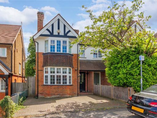 3 bedroom semi-detached house for sale in Park Road, Radlett, Hertfordshire, WD7 — £975,000 • 3 bed • 2 bath • 1459 ft²
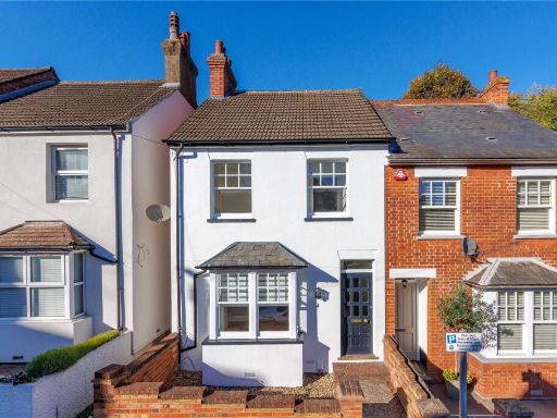 3 bedroom semi-detached house for sale in Aldenham Road, Radlett, Hertfordshire, WD7 — £800,000 • 3 bed • 1 bath • 1151 ft²
 5 bedroom detached house for sale in Hillside Road, Radlett, WD7 — £1,650,000 • 5 bed • 4 bath • 2729 ft²
 4 bedroom end of terrace house for sale in Watling Street, Radlett, Hertfordshire, WD7 — £800,000 • 4 bed • 2 bath • 1500 ft²
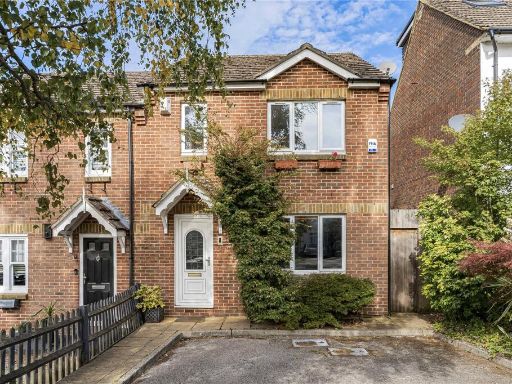 3 bedroom semi-detached house for sale in Gills Hill Lane, Radlett, Hertfordshire, WD7 — £760,000 • 3 bed • 2 bath • 1185 ft²
Meta
- {
"@context": "https://schema.org",
"@type": "Residence",
"name": "3 bedroom terraced house for sale in Station Road, Radlett,…",
"description": "",
"url": "https://propertypiper.co.uk/property/5294168d-55e4-4151-afcc-cce176c1dfeb",
"image": "https://image-a.propertypiper.co.uk/57899f9b-a417-4428-944f-d0432ca01ad4-1024.jpeg",
"address": {
"@type": "PostalAddress",
"streetAddress": "30 STATION ROAD RADLETT",
"postalCode": "WD7 8JX",
"addressLocality": "Hertsmere",
"addressRegion": "Hertsmere",
"addressCountry": "England"
},
"geo": {
"@type": "GeoCoordinates",
"latitude": 51.685432734015144,
"longitude": -0.3200121746147225
},
"numberOfRooms": 3,
"numberOfBathroomsTotal": 2,
"floorSize": {
"@type": "QuantitativeValue",
"value": 829,
"unitCode": "FTK"
},
"offers": {
"@type": "Offer",
"price": 650000,
"priceCurrency": "GBP",
"availability": "https://schema.org/InStock"
},
"additionalProperty": [
{
"@type": "PropertyValue",
"name": "Feature",
"value": "Victorian"
},
{
"@type": "PropertyValue",
"name": "Feature",
"value": "terraced house"
},
{
"@type": "PropertyValue",
"name": "Feature",
"value": "brick facade"
},
{
"@type": "PropertyValue",
"name": "Feature",
"value": "two-storey"
},
{
"@type": "PropertyValue",
"name": "Feature",
"value": "bay window"
},
{
"@type": "PropertyValue",
"name": "Feature",
"value": "chimneys"
},
{
"@type": "PropertyValue",
"name": "Feature",
"value": "small front garden"
},
{
"@type": "PropertyValue",
"name": "Feature",
"value": "potential"
},
{
"@type": "PropertyValue",
"name": "Feature",
"value": "modern"
},
{
"@type": "PropertyValue",
"name": "Feature",
"value": "parquet flooring"
},
{
"@type": "PropertyValue",
"name": "Feature",
"value": "bright"
},
{
"@type": "PropertyValue",
"name": "Feature",
"value": "living room"
},
{
"@type": "PropertyValue",
"name": "Feature",
"value": "staircase"
},
{
"@type": "PropertyValue",
"name": "Feature",
"value": "open shelving"
}
]
}
High Res Floorplan Images
Compatible Floorplan Images
FloorplanImages Thumbnail