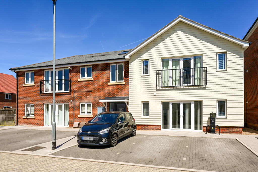
GU16 6GY - 2 bedroom flat for sale in Woodland Glade, Watersedge, GU16
View on Property Piper
2 bedroom flat for sale in Woodland Glade, Watersedge, GU16
Property Details
- Price: £195000
- Bedrooms: 2
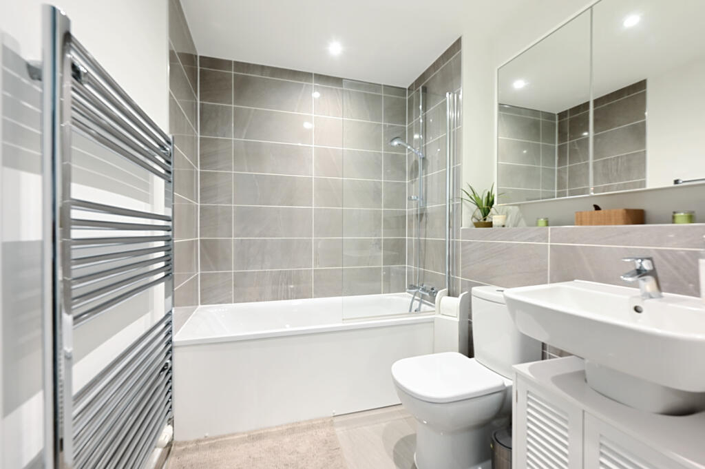
- Bathrooms: 1
- Property Type: undefined
- Property SubType: undefined
Image Descriptions
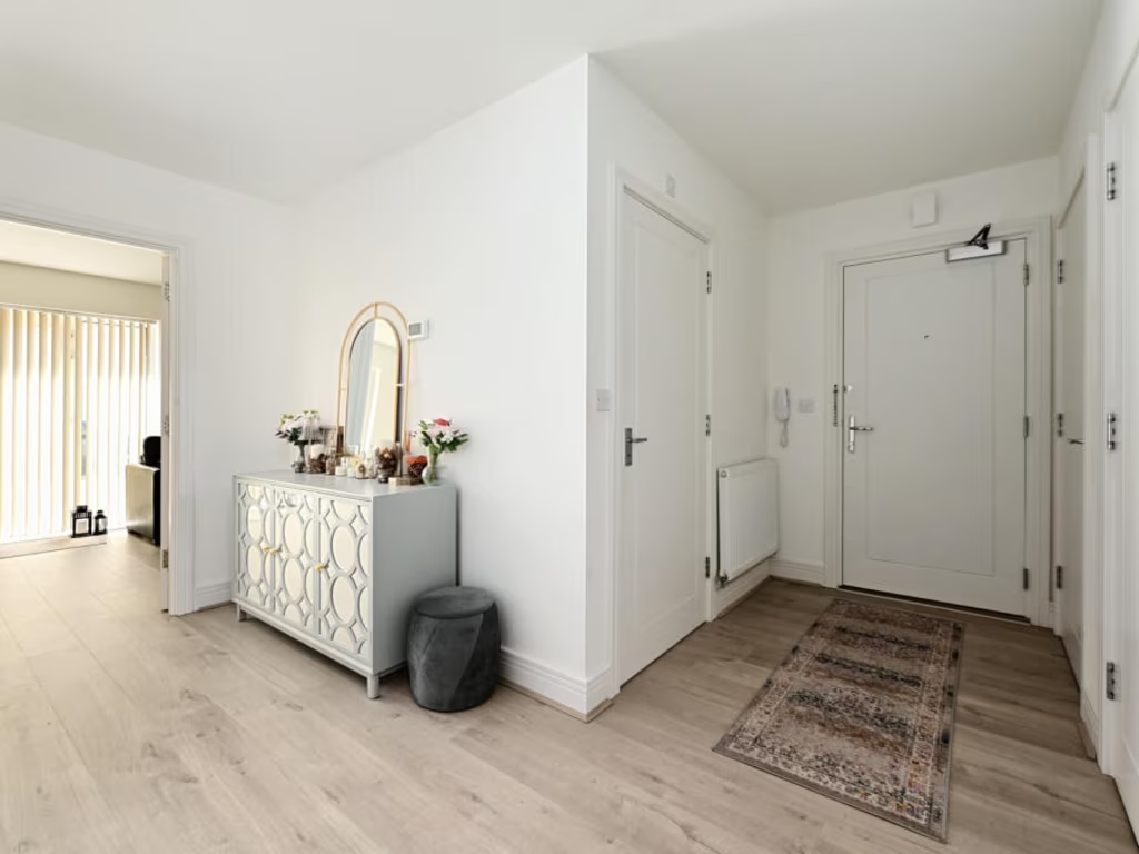
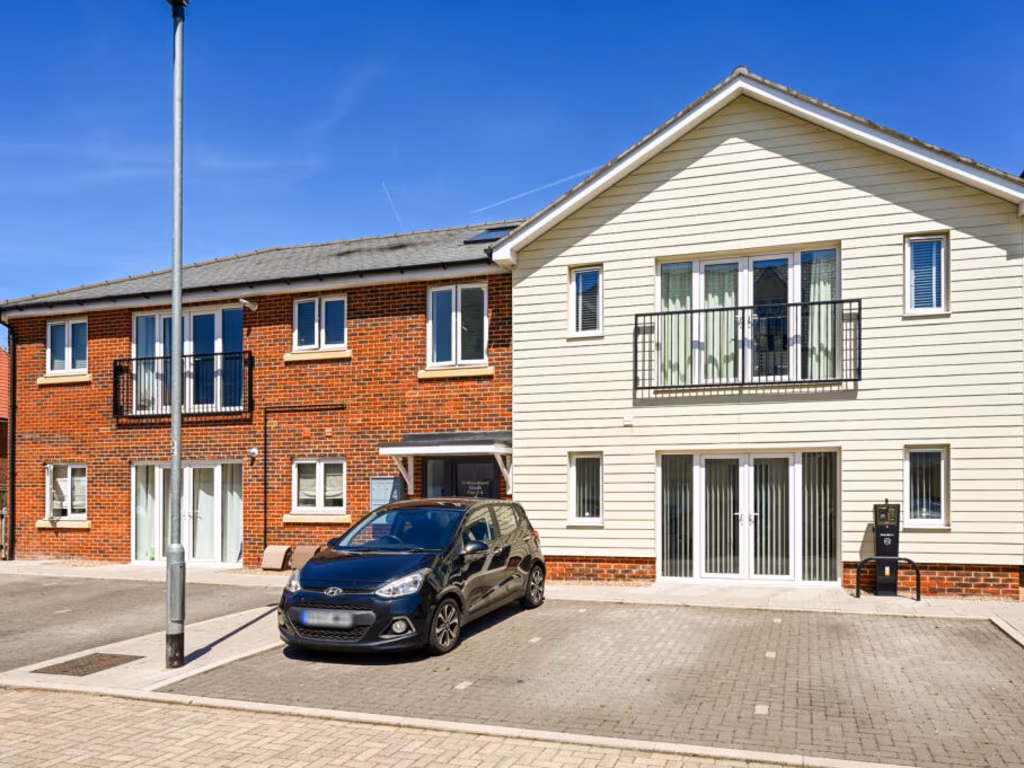
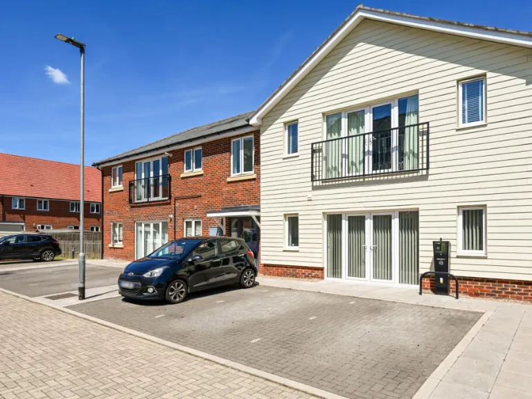
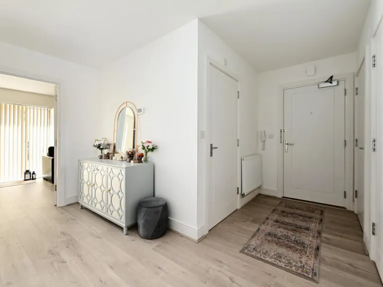
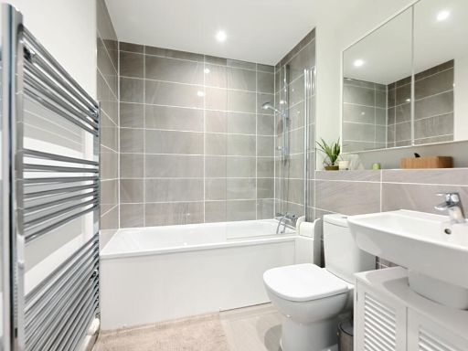
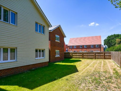
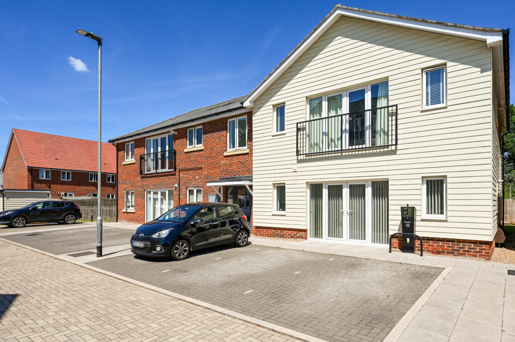
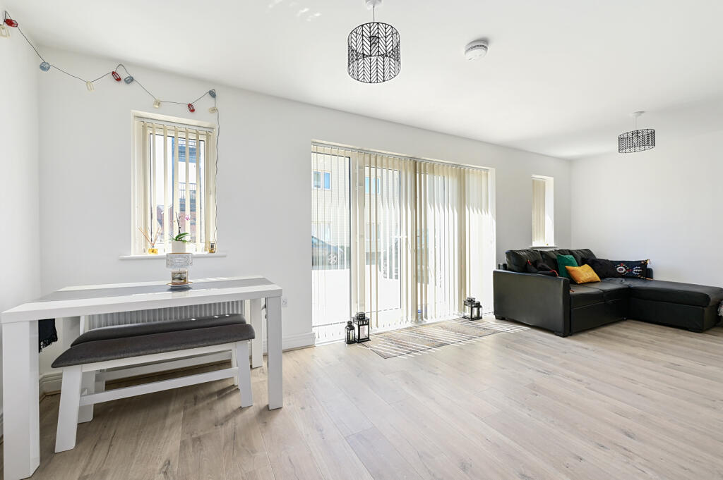
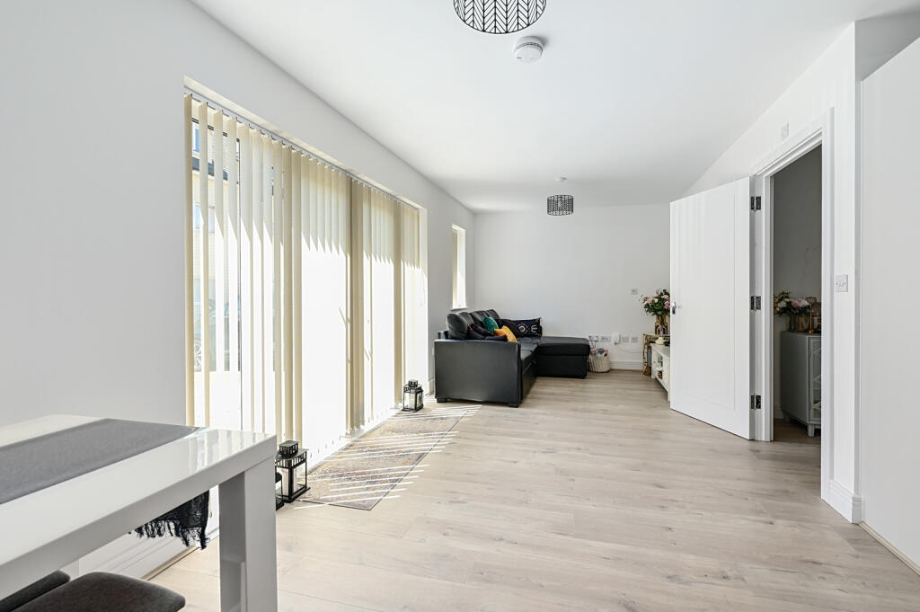
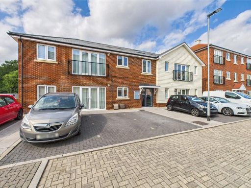
- modern house contemporary
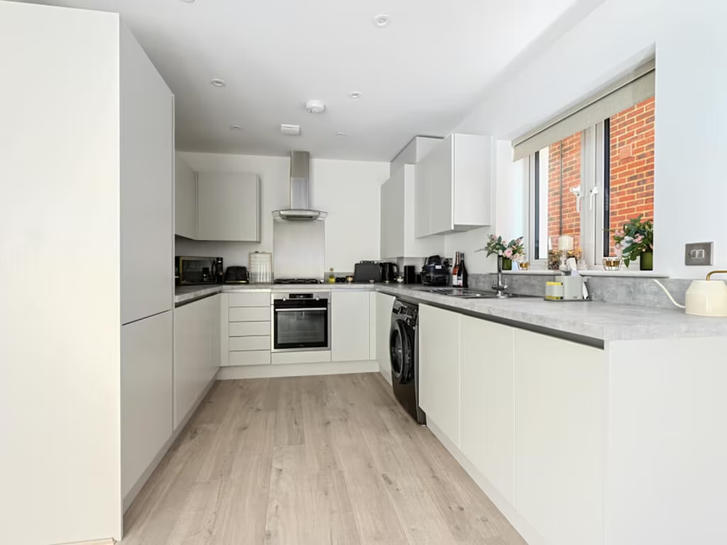
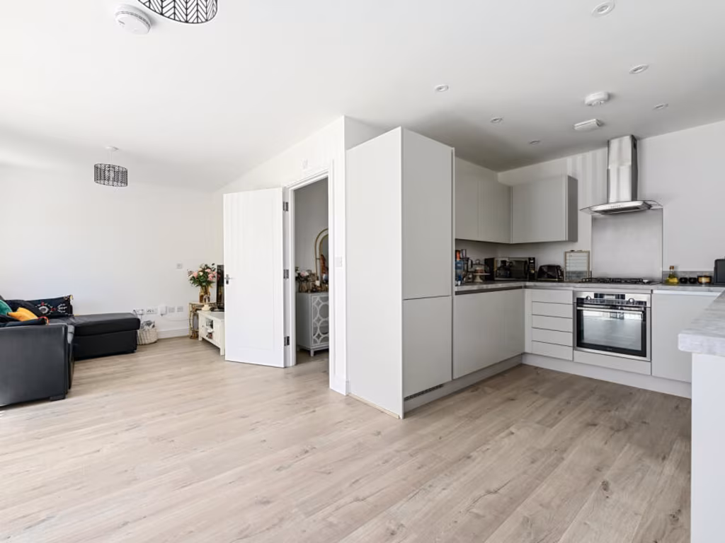
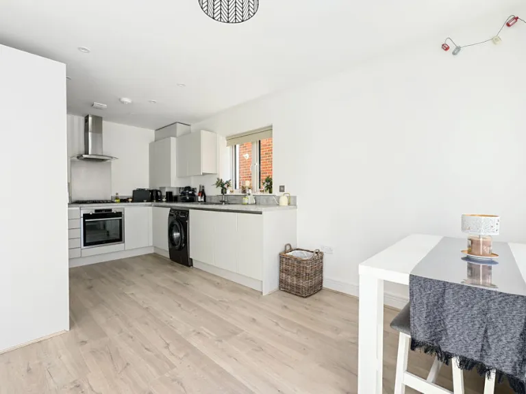
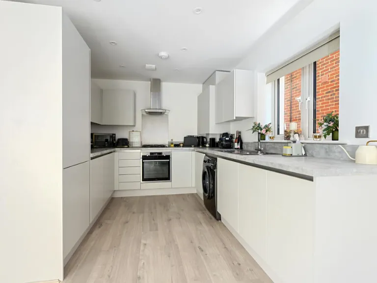
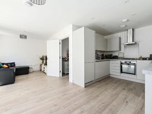
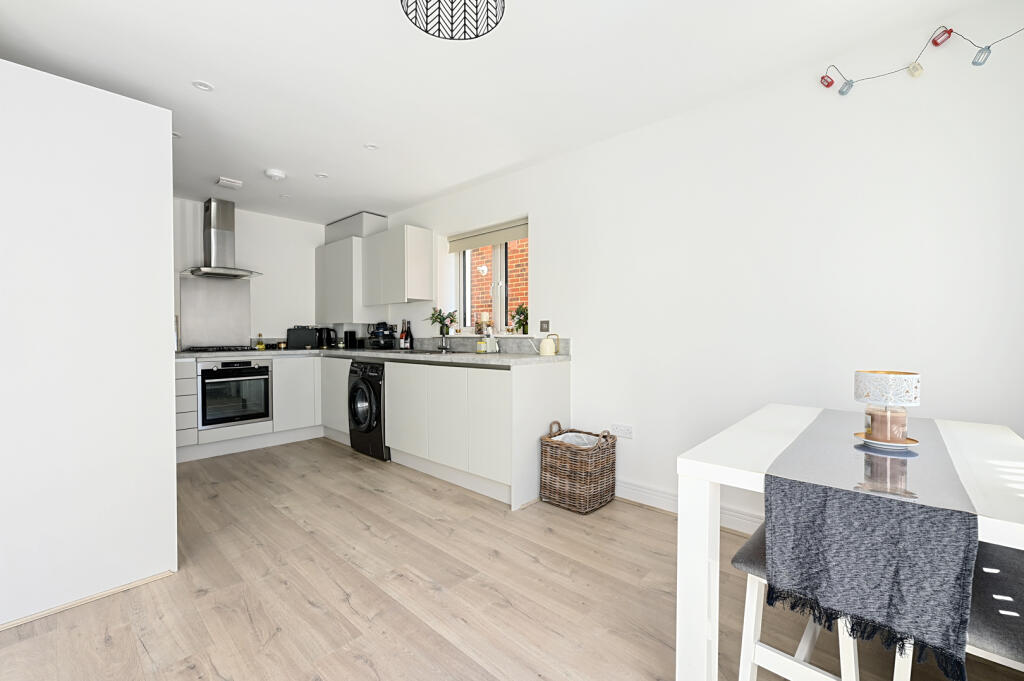
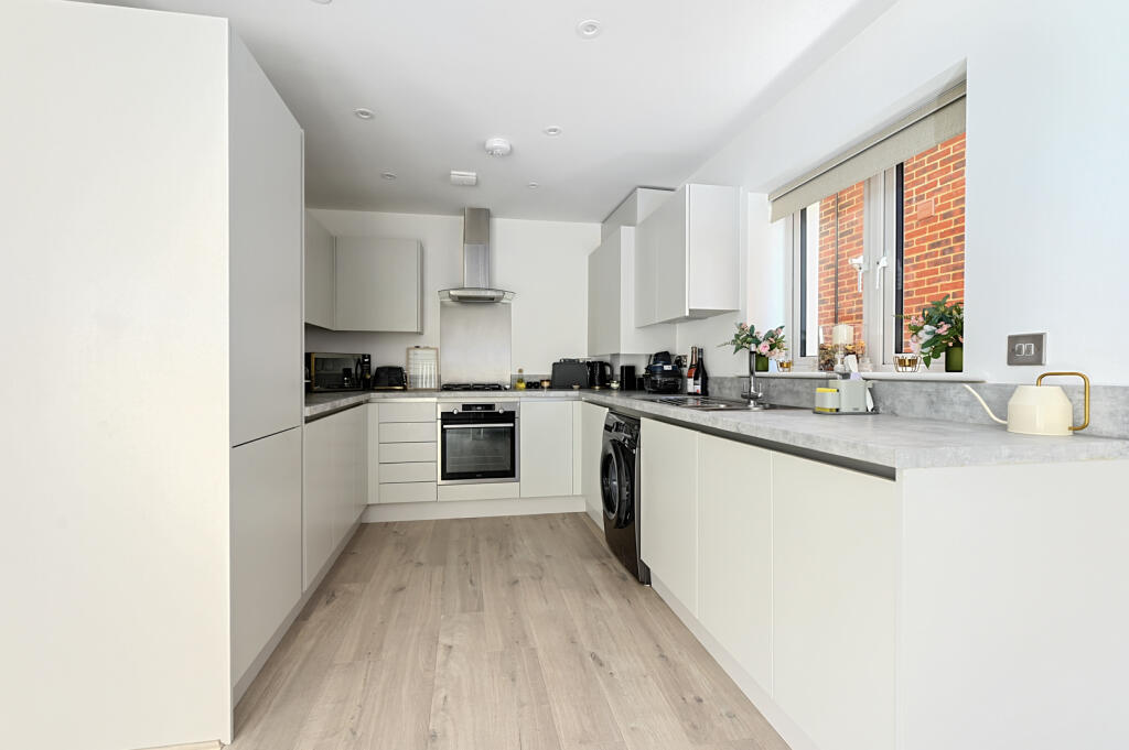
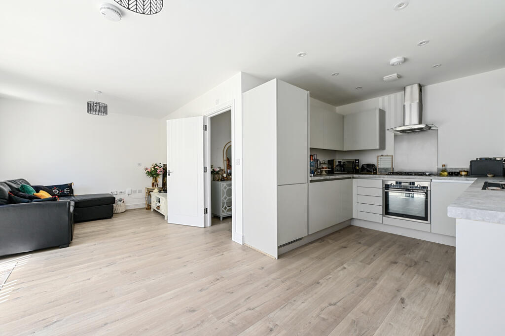
- kitchen contemporary
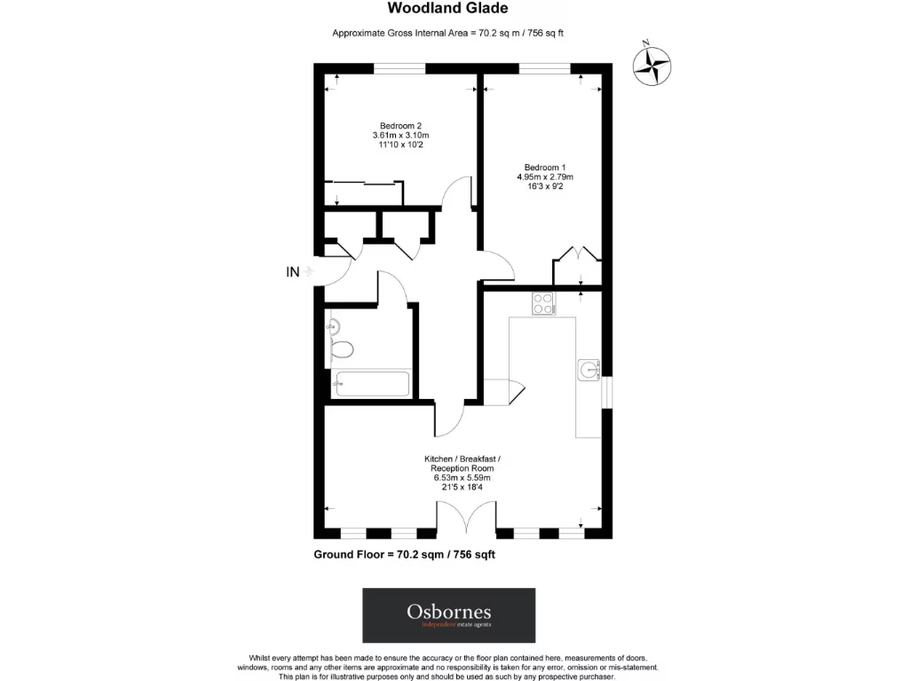
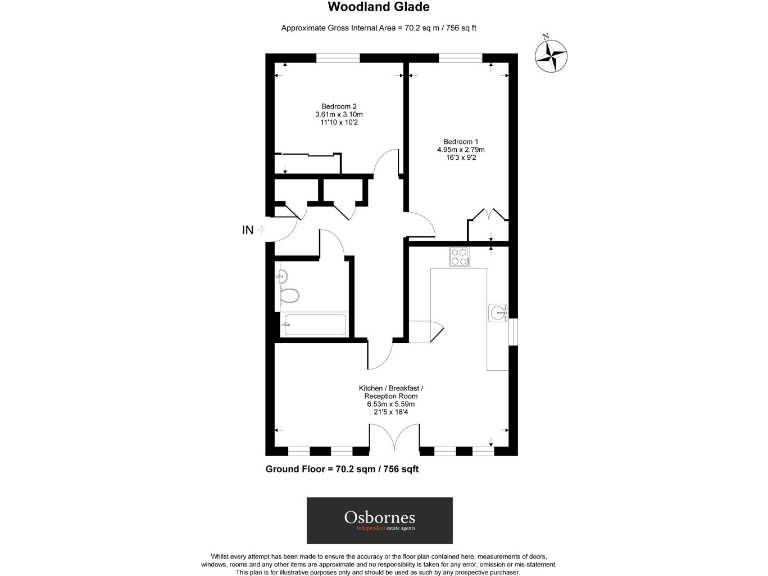
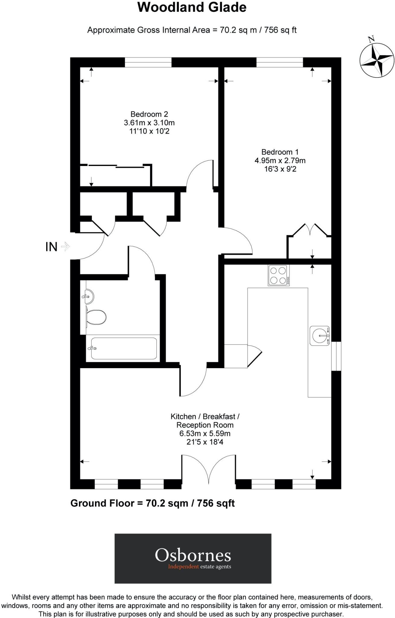
Rooms
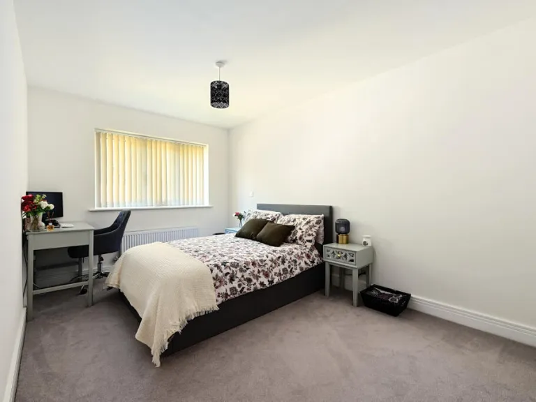
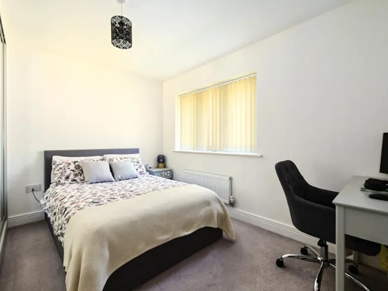
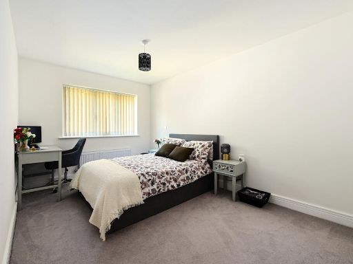
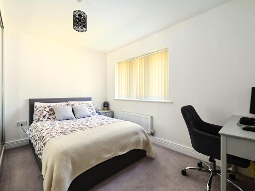
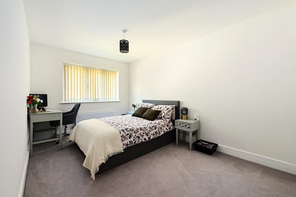
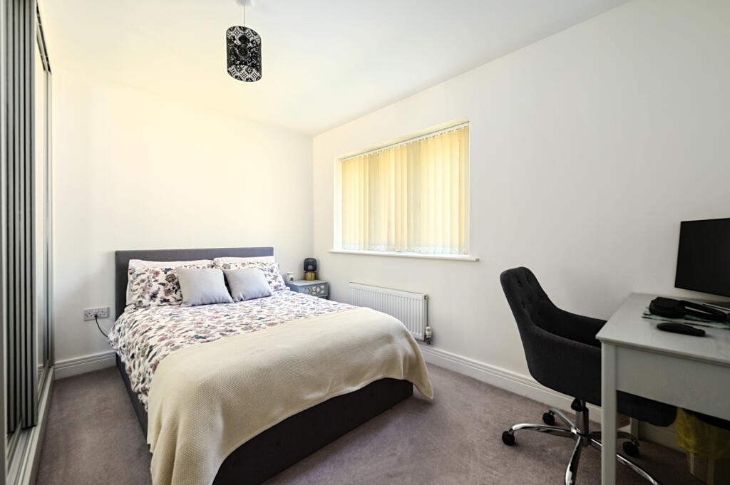
- Bedroom 2:
- Bedroom 1:
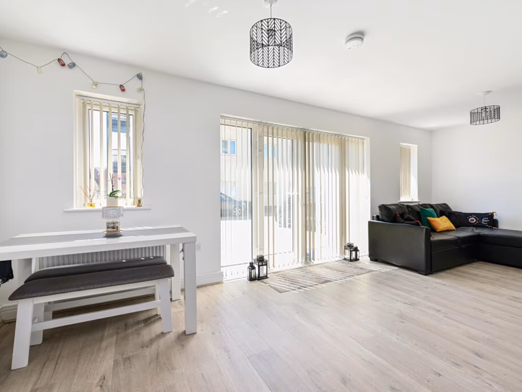
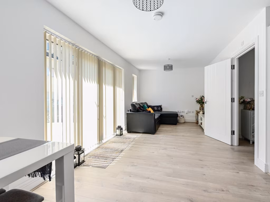
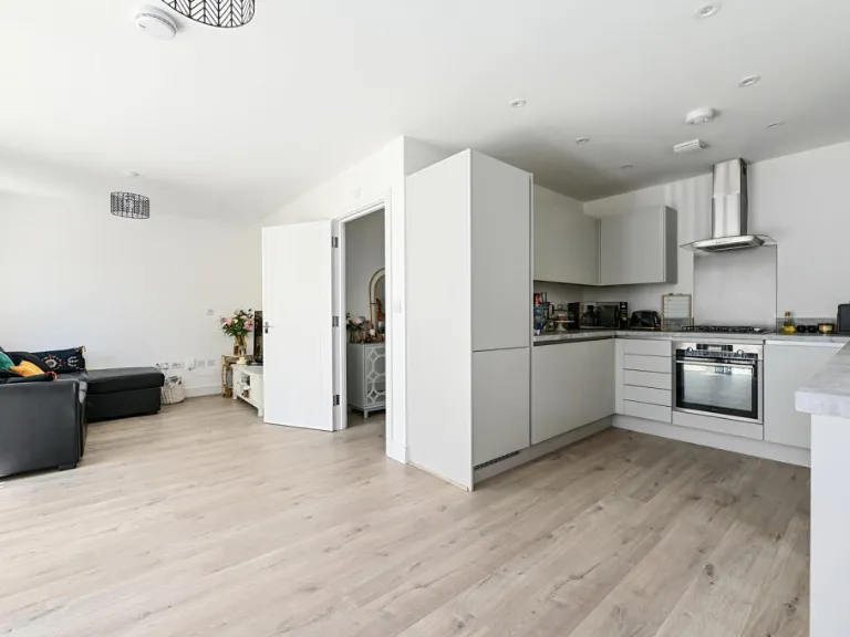
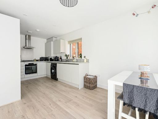
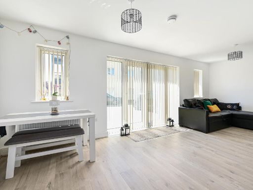
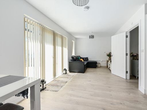
- Kitchen / Breakfast / Reception Room:
Textual Property Features
- Is Shared Ownership
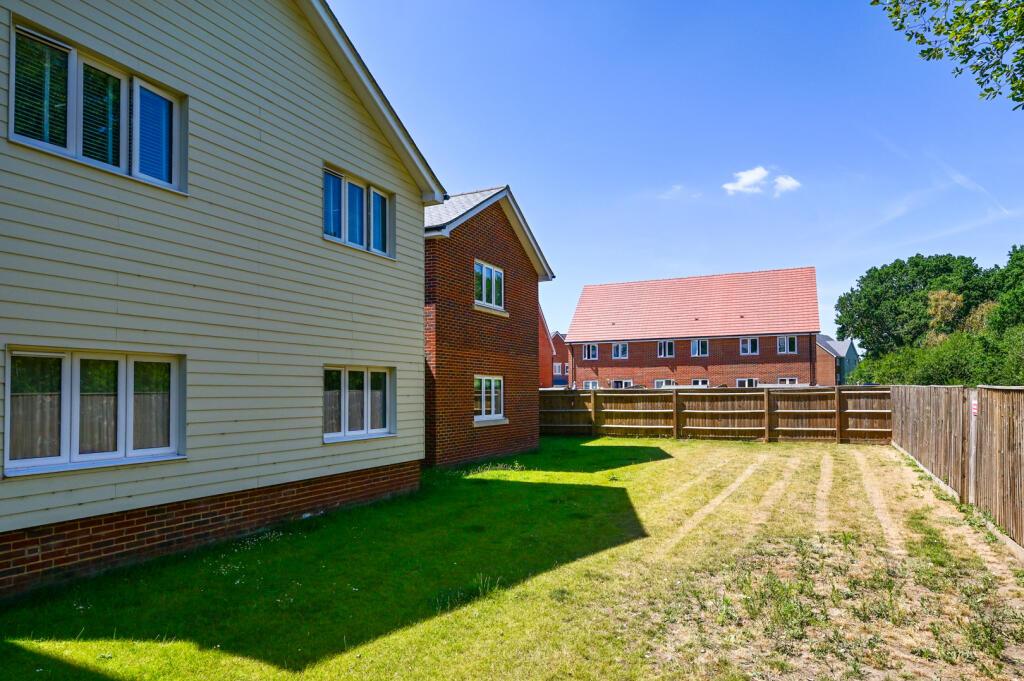
- Has Garden
- Success
Detected Visual Features
- modern
- contemporary
- recent construction
- suburban
- parking space
- low maintenance
- contemporary kitchen
- bright
- open-plan
- laminate flooring
- white cabinetry
- built-in appliances
- corner kitchen
EPC Details
- High performance glazing
- Average thermal transmittance 0.22 W/m-¦K
- Boiler and radiators, mains gas
- Low energy lighting in all fixed outlets
- (other premises below)
Nearby Schools
- Salesian College
- Mytchett Primary & Nursery Academy
- St Bernadette's Catholic Primary School
- Frimley CofE Junior School
- The Grove Primary Academy
- St Mark's Church of England Aided Primary School
- St Patrick's Catholic Primary School
- St Peter's Church of England Aided Junior School
- Cross Farm Infant Academy
- Tomlinscote School
- St Augustine's Catholic Primary School
- Ravenscote Junior School
- Ash Manor School
- Alderwood School
- Ash Grange Nursery and Primary School
- The Wavell School
- South Farnborough Infant School
- North Farnborough Infant School
- Walsh CofE Junior School
- Walsh CofE Infant School
- Shawfield Primary School
- Marlborough Infant School
- Holly Lodge Primary Academy
- South Farnborough Junior School
- Farnborough Hill
- Cherrywood Community Primary School
- Lakeside Nursery & Primary Academy
- Sandringham Infant & Nursery Academy
Nearest Bars And Restaurants
- Id: 9568955998
- Tags:
- Amenity: restaurant
- Name: Mytchett Chinese takeaway
- TagsNormalized:
- restaurant
- chinese
- takeaway
- Lat: 51.2933781
- Lon: -0.7261852
- FullGeoHash: gcp7z3xjwdtn
- PartitionGeoHash: gcp7
- Images:
- FoodStandards: null
- Distance: 1042.9
,- Id: 9568982633
- Tags:
- Amenity: cafe
- Name: Eat well cafe
- TagsNormalized:
- Lat: 51.2933075
- Lon: -0.7262097
- FullGeoHash: gcp7z3xjnjdc
- PartitionGeoHash: gcp7
- Images:
- FoodStandards: null
- Distance: 1034.9
,- Id: 366948355
- Tags:
- Amenity: pub
- Name: The Old Ford
- Source: photo
- Wheelchair: no
- TagsNormalized:
- Lat: 51.2754143
- Lon: -0.731084
- FullGeoHash: gcp7xq7suw02
- PartitionGeoHash: gcp7
- Images:
- FoodStandards: null
- Distance: 987
,- Id: 9568931808
- Tags:
- Amenity: restaurant
- Name: Spice loinge
- TagsNormalized:
- Lat: 51.2927338
- Lon: -0.7262272
- FullGeoHash: gcp7z3x1vdtg
- PartitionGeoHash: gcp7
- Images:
- FoodStandards: null
- Distance: 971.4
,- Id: 428568842
- Tags:
- Addr:
- Street: MYTCHETT PLACE ROAD
- Amenity: cafe
- Fhrs:
- Name: Canal Cafe
- Outdoor_seating: yes
- Source:
- Wheelchair: yes
- TagsNormalized:
- Lat: 51.2881979
- Lon: -0.7201857
- FullGeoHash: gcp7z8ex6mn9
- PartitionGeoHash: gcp7
- Images:
- FoodStandards:
- Id: 102205
- FHRSID: 102205
- LocalAuthorityBusinessID: 338
- BusinessName: Canal Cafe
- BusinessType: Restaurant/Cafe/Canteen
- BusinessTypeID: 1
- AddressLine1: Canal Centre
- AddressLine2: Mytchett Place Road
- AddressLine3: Mytchett
- AddressLine4: Camberley
- PostCode: GU16 6DD
- RatingValue: 4
- RatingKey: fhrs_4_en-GB
- RatingDate: 2022-02-09
- LocalAuthorityCode: 312
- LocalAuthorityName: Surrey Heath
- LocalAuthorityWebSite: http://www.surreyheath.gov.uk
- LocalAuthorityEmailAddress: environmental.health@surreyheath.gov.uk
- Scores:
- Hygiene: 5
- Structural: 10
- ConfidenceInManagement: 5
- NewRatingPending: false
- Geocode:
- Longitude: -0.72049590000000
- Latitude: 51.28782460000000
- Distance: 704.1
}
Nearest General Shops
- Id: 169964281
- Tags:
- Addr:
- Postcode: GU14 6JD
- Street: Lynchford Lane
- Name: Kebur Garden Materials
- Phone: +44 1252 517571
- Shop: garden_centre
- Trade: garden_supplies
- Website: https://www.kebur.co.uk/
- TagsNormalized:
- Lat: 51.2766639
- Lon: -0.7336831
- FullGeoHash: gcp7xq9spyyn
- PartitionGeoHash: gcp7
- Images:
- FoodStandards: null
- Distance: 916.9
,- Id: 946704675
- Tags:
- TagsNormalized:
- Lat: 51.2798493
- Lon: -0.7376481
- FullGeoHash: gcp7xpnyg8c8
- PartitionGeoHash: gcp7
- Images:
- FoodStandards: null
- Distance: 826.9
,- Id: 660759815
- Tags:
- Addr:
- Building: yes
- Contact:
- Phone: +44 1252 373388
- Website: http://themytchettgarage.co.uk/
- Name: The Mytchett Garage
- Shop: car_repair
- TagsNormalized:
- garage
- car repair
- repair
- shop
- Lat: 51.2901853
- Lon: -0.7255127
- FullGeoHash: gcp7z3pdyrd8
- PartitionGeoHash: gcp7
- Images:
- FoodStandards: null
- Distance: 700.5
}
Nearest Grocery shops
- Id: 9569089437
- Tags:
- Name: Welcome Mytchett
- Not:
- Opening_hours: Mo-Su 07:00-21:00
- Operator: Co-op
- Shop: convenience
- TagsNormalized:
- Lat: 51.2903328
- Lon: -0.7255349
- FullGeoHash: gcp7z3pevg1b
- PartitionGeoHash: gcp7
- Images:
- FoodStandards: null
- Distance: 716.1
,- Id: 1670257179
- Tags:
- Addr:
- City: Ash Vale
- Country: GB
- Postcode: GU12 5PP
- Street: Frimley Road
- Unit: 2 Woodstock Villas
- Fhrs:
- Authority: Guildford
- Id: 1028187
- Local_authority_id: 10518
- Name: Woodstock Stores
- Shop: convenience
- TagsNormalized:
- Lat: 51.279032
- Lon: -0.7245537
- FullGeoHash: gcp7xx06h8ms
- PartitionGeoHash: gcp7
- Images:
- FoodStandards:
- Id: 1028187
- FHRSID: 1028187
- LocalAuthorityBusinessID: 10518
- BusinessName: Woodstock Stores
- BusinessType: Retailers - other
- BusinessTypeID: 4613
- AddressLine1: 2, Woodstock Villas Frimley Road
- AddressLine2: null
- AddressLine3: Ash Vale
- AddressLine4: Surrey
- PostCode: GU12 5PP
- RatingValue: 4
- RatingKey: fhrs_4_en-GB
- RatingDate: 2022-05-20
- LocalAuthorityCode: 307
- LocalAuthorityName: Guildford
- LocalAuthorityWebSite: http://www.guildford.gov.uk
- LocalAuthorityEmailAddress: regulatoryservices@guildford.gov.uk
- Scores:
- Hygiene: 0
- Structural: 10
- ConfidenceInManagement: 10
- NewRatingPending: false
- Geocode:
- Longitude: -0.72474300000000
- Latitude: 51.27946400000000
- Distance: 603.8
,- Id: 1193998014
- Tags:
- Brand: M&S Simply Food
- Brand:wikidata: Q714491
- Contact:
- Website: https://www.marksandspencer.com/stores/camberley-mytchett-bp-171
- Name: M&S Simply Food
- Shop: convenience
- Toilets: yes
- Wheelchair: yes
- TagsNormalized:
- m&s simply food
- food
- convenience
- shop
- Lat: 51.2868156
- Lon: -0.7257944
- FullGeoHash: gcp7z2rrrg27
- PartitionGeoHash: gcp7
- Images:
- FoodStandards: null
- Distance: 338.3
}
Nearest Supermarkets
- Id: 50160018
- Tags:
- Addr:
- Country: GB
- Postcode: GU14 7LT
- Street: Westmead
- Town: Farnborough
- Brand: Asda
- Brand:wikidata: Q297410
- Brand:wikipedia: en:Asda
- Contact:
- Facebook: https://www.facebook.com/asda/
- Twitter: @asda
- Website: https://storelocator.asda.com/south-east/farnborough/west-meade
- Fhrs:
- Name: Asda
- Opening_hours: Mo-Sa 00:00-24:00; Su off
- Operator: Asda Stores Ltd
- Shop: supermarket
- Toilets:
- Wheelchair: yes
- TagsNormalized:
- Lat: 51.2910406
- Lon: -0.7575597
- FullGeoHash: gcp7yc0rgwfw
- PartitionGeoHash: gcp7
- Images:
- FoodStandards:
- Id: 12755
- FHRSID: 12755
- LocalAuthorityBusinessID: 04/02153/HSFD
- BusinessName: Asda Superstore
- BusinessType: Retailers - supermarkets/hypermarkets
- BusinessTypeID: 7840
- AddressLine1: ASDA
- AddressLine2: Westmead
- AddressLine3: Farnborough
- AddressLine4: Hampshire
- PostCode: GU14 7LT
- RatingValue: 5
- RatingKey: fhrs_5_en-GB
- RatingDate: 2021-11-04
- LocalAuthorityCode: 140
- LocalAuthorityName: Rushmoor
- LocalAuthorityWebSite: http://www.rushmoor.gov.uk
- LocalAuthorityEmailAddress: food@rushmoor.gov.uk
- Scores:
- Hygiene: 5
- Structural: 0
- ConfidenceInManagement: 0
- NewRatingPending: false
- Geocode:
- Longitude: -0.75760900000000
- Latitude: 51.29104000000000
- Distance: 2207.5
,- Id: 344211915
- Tags:
- Brand:
- Building: commercial
- Name: Sainsbury's
- Operator: Sainsburys
- Shop: supermarket
- Toilets:
- Wheelchair: yes
- TagsNormalized:
- sainsburys
- supermarket
- shop
- Lat: 51.2929307
- Lon: -0.7561824
- FullGeoHash: gcp7yc96gxm9
- PartitionGeoHash: gcp7
- Images:
- FoodStandards: null
- Distance: 2203.9
,- Id: 763208781
- Tags:
- Brand: Iceland
- Brand:wikidata: Q721810
- Contact:
- Website: https://www.iceland.co.uk/store-finder/store?StoreID=686&StoreName=FARNBOROUGH
- Name: Iceland
- Shop: supermarket
- Wheelchair: yes
- TagsNormalized:
- Lat: 51.2905293
- Lon: -0.7552502
- FullGeoHash: gcp7yc4hcrss
- PartitionGeoHash: gcp7
- Images:
- FoodStandards: null
- Distance: 2037.2
}
Nearest Religious buildings
- Id: 878909135
- Tags:
- Amenity: place_of_worship
- Building: church
- Denomination: anglican
- Name: St Mark
- Religion: christian
- Wikidata: Q105085973
- TagsNormalized:
- place of worship
- church
- anglican
- christian
- Lat: 51.2814391
- Lon: -0.7465308
- FullGeoHash: gcp7xp82h947
- PartitionGeoHash: gcp7
- Images:
- FoodStandards: null
- Distance: 1331.8
,- Id: 955903605
- Tags:
- Amenity: place_of_worship
- Denomination: roman_catholic
- Name: Church of Our Lady
- Node_id: 955903605
- Religion: christian
- Source:
- Name: OS Open Local Important Buildings Layer
- TagsNormalized:
- place of worship
- catholic
- roman catholic
- church
- christian
- Lat: 51.2774713
- Lon: -0.7431957
- FullGeoHash: gcp7xnfbfm3n
- PartitionGeoHash: gcp7
- Images:
- FoodStandards: null
- Distance: 1294.7
,- Id: 660759816
- Tags:
- Addr:
- Amenity: place_of_worship
- Building: yes
- Contact:
- Denomination: baptist
- Name: Mytchett Baptist Church
- Religion: christian
- Service_times: Su 10:00
- TagsNormalized:
- place of worship
- baptist
- church
- christian
- Lat: 51.290616
- Lon: -0.7256277
- FullGeoHash: gcp7z3pt7xuf
- PartitionGeoHash: gcp7
- Images:
- FoodStandards: null
- Distance: 745.5
}
Nearest Medical buildings
- Id: 956029831
- Tags:
- Amenity: pharmacy
- Brand: Boots
- Brand:wikidata: Q6123139
- Brand:wikipedia: en:Boots UK
- Healthcare: pharmacy
- Name: Boots
- Operator: Boots
- Wheelchair: yes
- TagsNormalized:
- pharmacy
- boots
- health
- healthcare
- Lat: 51.2921445
- Lon: -0.7584756
- FullGeoHash: gcp7y9rwqhxx
- PartitionGeoHash: gcp7
- Images:
- FoodStandards: null
- Distance: 2312.2
,- Id: 7508813534
- Tags:
- Amenity: pharmacy
- Brand: Asda
- Brand:wikidata: Q297410
- Brand:wikipedia: en:Asda
- Contact:
- Phone: +44 1252 376074
- Website: https://storelocator.asda.com/south-east/farnborough/west-meade/pharmacy
- Drive_through: no
- Healthcare: pharmacy
- Name: Asda
- Operator: Asda Stores Ltd
- TagsNormalized:
- pharmacy
- asda
- health
- healthcare
- Lat: 51.2910249
- Lon: -0.7581422
- FullGeoHash: gcp7y9pzyh01
- PartitionGeoHash: gcp7
- Images:
- FoodStandards: null
- Distance: 2244.9
,- Id: 4567794693
- Tags:
- Amenity: doctors
- Name: Frimley Green Health Clinic
- TagsNormalized:
- doctor
- doctors
- clinic
- health
- Lat: 51.3027488
- Lon: -0.7255405
- FullGeoHash: gcp7z7rsjttc
- PartitionGeoHash: gcp7
- Images:
- FoodStandards: null
- Distance: 2084.6
,- Id: 179945416
- Tags:
- Addr:
- Amenity: dentist
- Building: yes
- Healthcare: dentist
- Name: The Station Dental Clinic
- TagsNormalized:
- Lat: 51.2757985
- Lon: -0.7311747
- FullGeoHash: gcp7xq7x4mss
- PartitionGeoHash: gcp7
- Images:
- FoodStandards: null
- Distance: 947
}
Nearest Airports
- Id: 14001268
- Tags:
- Access: yes
- Aerodrome: international
- Aerodrome:type: public
- Aeroway: aerodrome
- Alt_name: London Heathrow
- Alt_name_2: London Heathrow Airport
- Ele: 25
- Iata: LHR
- Icao: EGLL
- Int_name: Heathrow Airport
- Name: London Heathrow Airport
- Note: area still approx
- Old_name: London Airport
- Operator: Heathrow Airport Limited
- Rank_aci:
- Ref: LHR
- Short_name: Heathrow
- Type: multipolygon
- Website: https://www.heathrow.com/
- Wikidata: Q8691
- Wikipedia: en:Heathrow Airport
- TagsNormalized:
- airport
- international airport
- Lat: 51.4677522
- Lon: -0.4547736
- FullGeoHash: gcpsv9kv7h2h
- PartitionGeoHash: gcps
- Images:
- FoodStandards: null
- Distance: 27865
}
Nearest Leisure Facilities
- Id: 25872155
- Tags:
- Access: yes
- Leisure: playground
- Name: Carrington Rec
- TagsNormalized:
- Lat: 51.2768556
- Lon: -0.7252252
- FullGeoHash: gcp7xqxvm48y
- PartitionGeoHash: gcp7
- Images:
- FoodStandards: null
- Distance: 821.2
,- Id: 428568839
- Tags:
- Access: yes
- Leisure: playground
- Wheelchair: limited
- TagsNormalized:
- Lat: 51.2880311
- Lon: -0.7203476
- FullGeoHash: gcp7z8eqqtvy
- PartitionGeoHash: gcp7
- Images:
- FoodStandards: null
- Distance: 683.5
,- Id: 15509352
- Tags:
- Garden:
- Leisure: garden
- Type: multipolygon
- TagsNormalized:
- Lat: 51.2868566
- Lon: -0.720816
- FullGeoHash: gcp7z87peg08
- PartitionGeoHash: gcp7
- Images:
- FoodStandards: null
- Distance: 579.6
,- Id: 1240273973
- Tags:
- TagsNormalized:
- Lat: 51.2854319
- Lon: -0.7208679
- FullGeoHash: gcp7z85p693v
- PartitionGeoHash: gcp7
- Images:
- FoodStandards: null
- Distance: 508.8
,- Id: 245716689
- Tags:
- Fixme: actually operation?
- Golf:
- Leisure: golf_course
- Name: Water's Edge Driving Range
- Note: Not sure if actually operational? watersedgegolf.co.uk not operational; See e.g. http://www.getsurrey.co.uk/news/surrey-news/fresh-licence-bid-launched-waters-7983825
- TagsNormalized:
- Lat: 51.2840209
- Lon: -0.7291372
- FullGeoHash: gcp7xrvp1f7u
- PartitionGeoHash: gcp7
- Images:
- FoodStandards: null
- Distance: 90
}
Nearest Tourist attractions
- Id: 428568835
- Tags:
- Name: Basingstoke Canal Visitor Centre
- Postal_code: GU16 6DD
- Toilets:
- Tourism: attraction
- Wheelchair: yes
- TagsNormalized:
- Lat: 51.287793
- Lon: -0.7205078
- FullGeoHash: gcp7z8em4cw6
- PartitionGeoHash: gcp7
- Images:
- FoodStandards: null
- Distance: 658
,- Id: 32840734
- Tags:
- Landuse: residential
- Name: Grove Farm Park Mobile Home Park
- Tourism: caravan_site
- TagsNormalized:
- residential
- farm
- caravan
- tourism
- Lat: 51.2810752
- Lon: -0.7289191
- FullGeoHash: gcp7xrmjyvq9
- PartitionGeoHash: gcp7
- Images:
- FoodStandards: null
- Distance: 339.8
,- Id: 36789974
- Tags:
- Landuse: residential
- Name: Mytchett Farm (Mobile Home Park)
- Tourism: caravan_site
- TagsNormalized:
- residential
- farm
- caravan
- tourism
- Lat: 51.2858326
- Lon: -0.728366
- FullGeoHash: gcp7z2m9eu4u
- PartitionGeoHash: gcp7
- Images:
- FoodStandards: null
- Distance: 200.8
}
Nearest Train stations
- Id: 3509618076
- Tags:
- Name: Farnborough (Main)
- Naptan:
- Network: National Rail
- Operator: South West Trains
- Public_transport: station
- Railway: station
- Ref:
- Wikidata: Q1941502
- Wikipedia: en:Farnborough (Main) railway station
- TagsNormalized:
- Lat: 51.2968188
- Lon: -0.7555158
- FullGeoHash: gcp7yf3cehne
- PartitionGeoHash: gcp7
- Images:
- FoodStandards: null
- Distance: 2390.9
,- Id: 1682237600
- Tags:
- Name: Farnborough North
- Naptan:
- Network: National Rail
- Operator: First Great Western
- Public_transport: station
- Railway: station
- Ref:
- Wheelchair: limited
- Wikidata: Q2498080
- Wikipedia: en:Farnborough North railway station
- TagsNormalized:
- Lat: 51.3021991
- Lon: -0.7429378
- FullGeoHash: gcp7z570br13
- PartitionGeoHash: gcp7
- Images:
- FoodStandards: null
- Distance: 2274
,- Id: 702387855
- Tags:
- Name: Frimley Lodge Miniature Railway
- Public_transport: station
- Railway: station
- Usage: tourism
- Website: https://www.flmr.org/
- Wikipedia: en:Frimley Lodge Park Railway
- TagsNormalized:
- Lat: 51.2962035
- Lon: -0.7217326
- FullGeoHash: gcp7zd4qn3mh
- PartitionGeoHash: gcp7
- Images:
- FoodStandards: null
- Distance: 1416
,- Id: 5967525975
- Tags:
- Name: Ash Vale
- Naptan:
- Network: National Rail
- Operator: South Western Railway
- Public_transport: station
- Railway: station
- Ref:
- Wikidata: Q4774283
- Wikipedia: en:Ash Vale railway station
- TagsNormalized:
- Lat: 51.2723368
- Lon: -0.7216468
- FullGeoHash: gcp7xtfe02m4
- PartitionGeoHash: gcp7
- Images:
- FoodStandards: null
- Distance: 1372.7
,- Id: 7159068185
- Tags:
- Addr:
- Postcode: GU12 5QA
- Street: Lynchford Road
- Name: North Camp
- Naptan:
- Network: National Rail
- Operator: First Great Western
- Public_transport: station
- Railway: station
- Ref:
- Wheelchair: yes
- Wikidata: Q2297819
- Wikipedia: en:North Camp railway station
- TagsNormalized:
- Lat: 51.2753951
- Lon: -0.7307328
- FullGeoHash: gcp7xq7uudqj
- PartitionGeoHash: gcp7
- Images:
- FoodStandards: null
- Distance: 983.8
}
Nearest Hotels
- Id: 385246313
- Tags:
- Amenity: restaurant
- Name: Aviator
- Stars: 4/5
- Tourism: hotel
- TagsNormalized:
- Lat: 51.2793048
- Lon: -0.7548874
- FullGeoHash: gcp7wz479g70
- PartitionGeoHash: gcp7
- Images:
- FoodStandards: null
- Distance: 1953.6
,- Id: 385246315
- Tags:
- Addr:
- City: Farnborough
- Housenumber: 68
- Postcode: GU14 6TH
- Street: Farnborough Road
- Name: Falcon Hotel
- Tourism: hotel
- TagsNormalized:
- Lat: 51.281761
- Lon: -0.752737
- FullGeoHash: gcp7wzecgvne
- PartitionGeoHash: gcp7
- Images:
- FoodStandards: null
- Distance: 1749.9
,- Id: 108035302
- Tags:
- Amenity: pub
- Building: yes
- Name: Potter's Inn
- Toilets:
- Tourism: hotel
- Wheelchair: yes
- TagsNormalized:
- Lat: 51.2858534
- Lon: -0.7206166
- FullGeoHash: gcp7z873b2j2
- PartitionGeoHash: gcp7
- Images:
- FoodStandards: null
- Distance: 541
}
Tags
- modern
- contemporary
- recent construction
- suburban
- parking space
- low maintenance
- contemporary kitchen
- modern
- bright
- open-plan
- laminate flooring
- white cabinetry
- built-in appliances
- corner kitchen
Local Market Stats
- Average Price/sqft: £438
- Avg Income: £66200
- Rental Yield: 3.9%
- Social Housing: 8%
- Planning Success Rate: 85%
Similar Properties
 2 bedroom apartment for sale in Woodland Glade, Mytchett, Camberley, Surrey, GU16 — £204,750 • 2 bed • 1 bath • 764 ft²
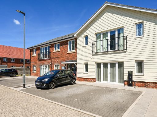 2 bedroom flat for sale in Woodland Glade, Watersedge, GU16 — £300,000 • 2 bed • 1 bath • 750 ft²
 2 bedroom flat for sale in Woodland Glade, Mytchett, Surrey, GU16 — £195,005 • 2 bed • 1 bath • 750 ft²
 2 bedroom flat for sale in Woodland Glade, Mytchett, Camberley, Surrey, GU16 — £315,000 • 2 bed • 1 bath • 750 ft²
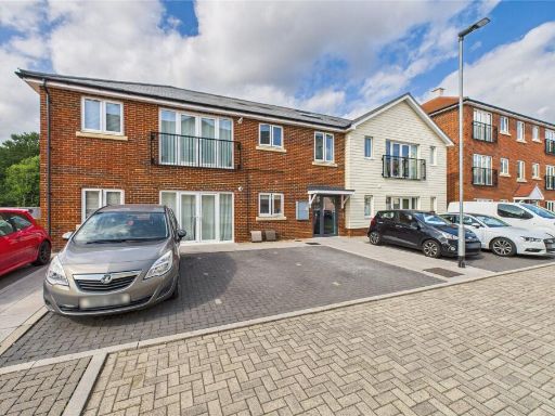 2 bedroom apartment for sale in Woodland Glade, Mytchett, Camberley, Surrey, GU16 — £315,000 • 2 bed • 1 bath • 764 ft²
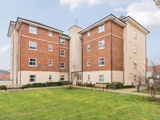 1 bedroom apartment for sale in Sopwith Drive, Farnborough, GU14 — £96,000 • 1 bed • 1 bath • 624 ft²
Meta
- {
"@context": "https://schema.org",
"@type": "Residence",
"name": "2 bedroom flat for sale in Woodland Glade, Watersedge, GU16",
"description": "",
"url": "https://propertypiper.co.uk/property/4e77ead7-c3dd-4898-8b6a-8ff5e1bebb15",
"image": "https://image-a.propertypiper.co.uk/09cfd1ee-9091-4b47-8f0b-fe76f3c01d62-1024.jpeg",
"address": {
"@type": "PostalAddress",
"streetAddress": "Woodland Glade, Watersedge, GU16",
"postalCode": "GU16 6GY",
"addressLocality": "Surrey Heath",
"addressRegion": "Surrey Heath",
"addressCountry": "England"
},
"geo": {
"@type": "GeoCoordinates",
"latitude": 51.28405664280993,
"longitude": -0.7278450847395905
},
"numberOfRooms": 2,
"numberOfBathroomsTotal": 1,
"floorSize": {
"@type": "QuantitativeValue",
"value": 750,
"unitCode": "FTK"
},
"offers": {
"@type": "Offer",
"price": 195000,
"priceCurrency": "GBP",
"availability": "https://schema.org/InStock"
},
"additionalProperty": [
{
"@type": "PropertyValue",
"name": "Feature",
"value": "modern"
},
{
"@type": "PropertyValue",
"name": "Feature",
"value": "contemporary"
},
{
"@type": "PropertyValue",
"name": "Feature",
"value": "recent construction"
},
{
"@type": "PropertyValue",
"name": "Feature",
"value": "suburban"
},
{
"@type": "PropertyValue",
"name": "Feature",
"value": "parking space"
},
{
"@type": "PropertyValue",
"name": "Feature",
"value": "low maintenance"
},
{
"@type": "PropertyValue",
"name": "Feature",
"value": "contemporary kitchen"
},
{
"@type": "PropertyValue",
"name": "Feature",
"value": "modern"
},
{
"@type": "PropertyValue",
"name": "Feature",
"value": "bright"
},
{
"@type": "PropertyValue",
"name": "Feature",
"value": "open-plan"
},
{
"@type": "PropertyValue",
"name": "Feature",
"value": "laminate flooring"
},
{
"@type": "PropertyValue",
"name": "Feature",
"value": "white cabinetry"
},
{
"@type": "PropertyValue",
"name": "Feature",
"value": "built-in appliances"
},
{
"@type": "PropertyValue",
"name": "Feature",
"value": "corner kitchen"
}
]
}
High Res Floorplan Images
Compatible Floorplan Images
FloorplanImages Thumbnail