WV6 8QJ - 2 bedroom flat for sale in Flat 6, The Manor House, Upper G…
View on Property Piper
2 bedroom flat for sale in Flat 6, The Manor House, Upper Green, Tettenhall, Wolverhampton, WV6 8QJ, WV6
Property Details
- Price: £499950
- Bedrooms: 2
- Bathrooms: 2
- Property Type: undefined
- Property SubType: undefined
Brochure Descriptions
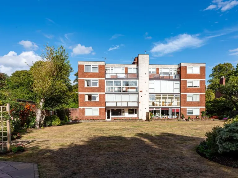
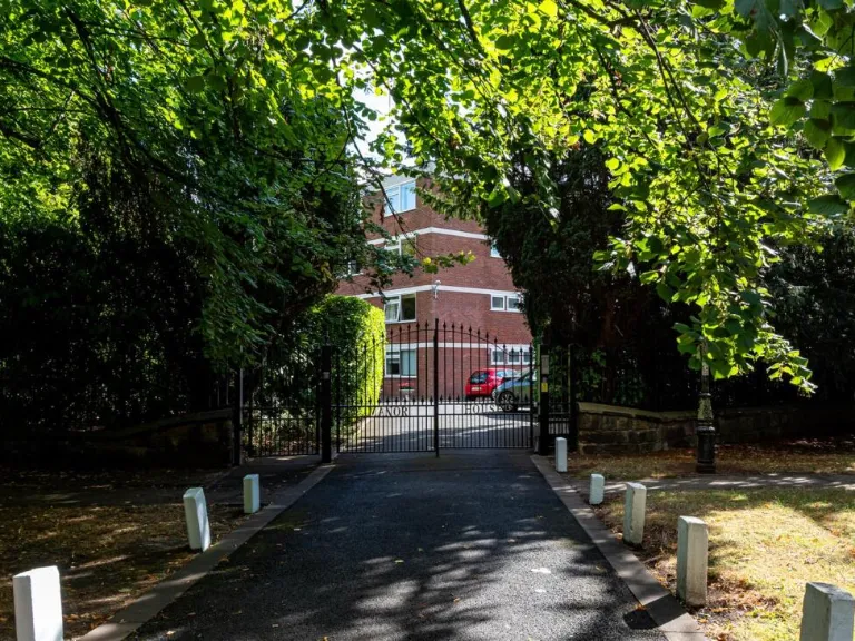
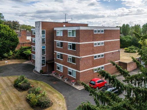
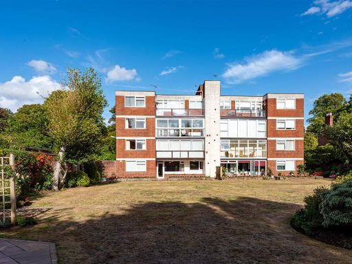
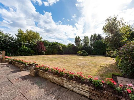
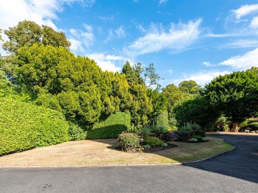
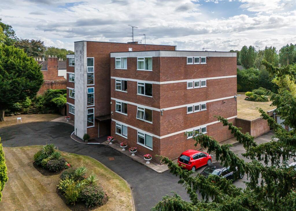
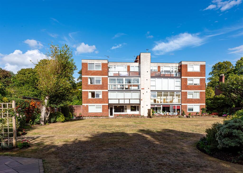
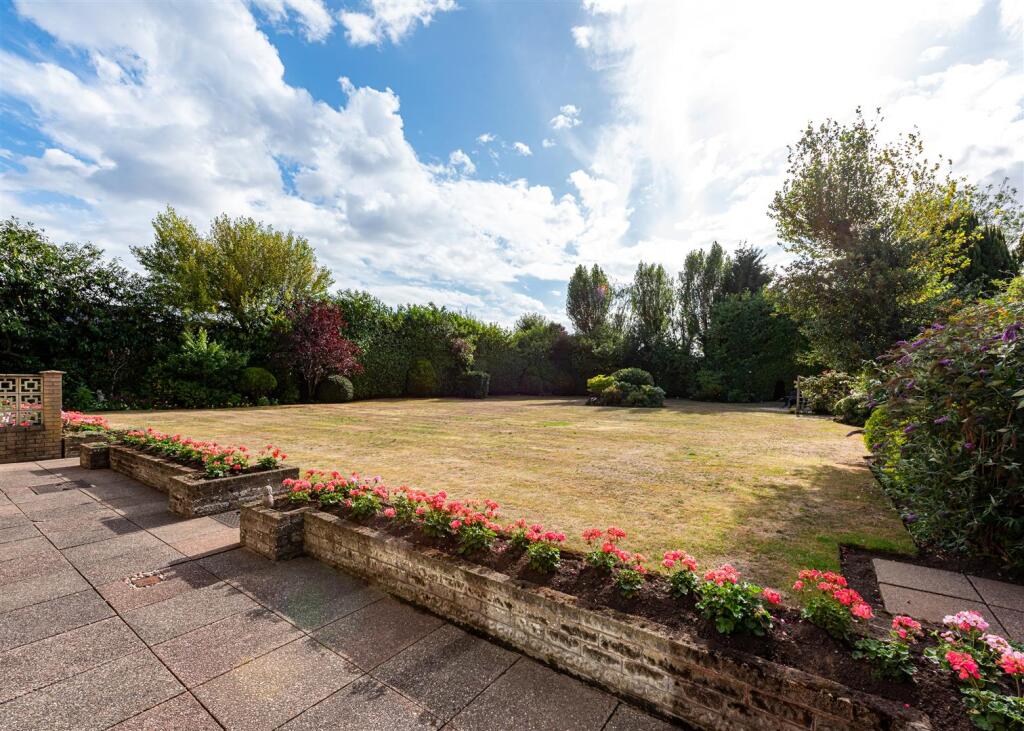
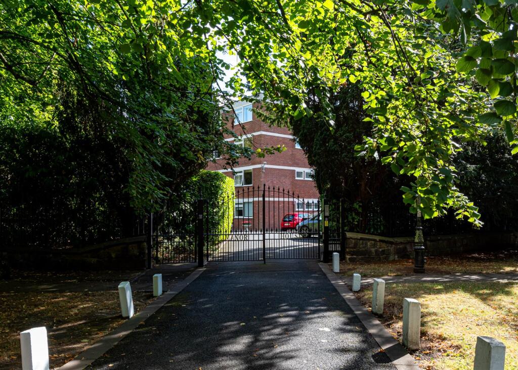
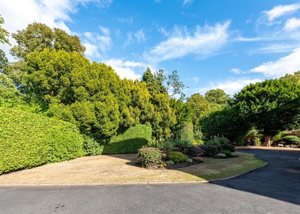
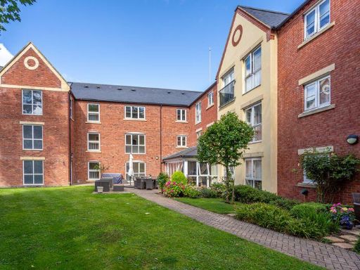
- Purpose-built, mid-20th century 3–4 storey brick apartment block set in mature communal grounds. The subject is a first/upper floor flat (Flat 6) within a rectangular, low-rise block with banded concrete detailing. Exterior shows communal entrance core and on-site parking for residents, well-kept lawns, shrub beds and private communal garden to the rear. Setting appears suburban with tree-lined boundaries providing privacy and pleasant green outlooks. Overall site footprint and grounds are modest/average for a small apartment development; the individual flat is likely small-to-average in size for a one- or two-bedroom unit given building scale.
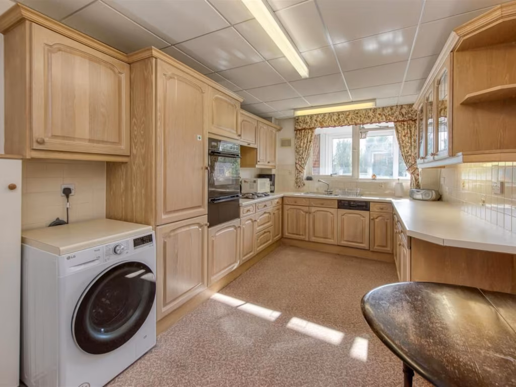
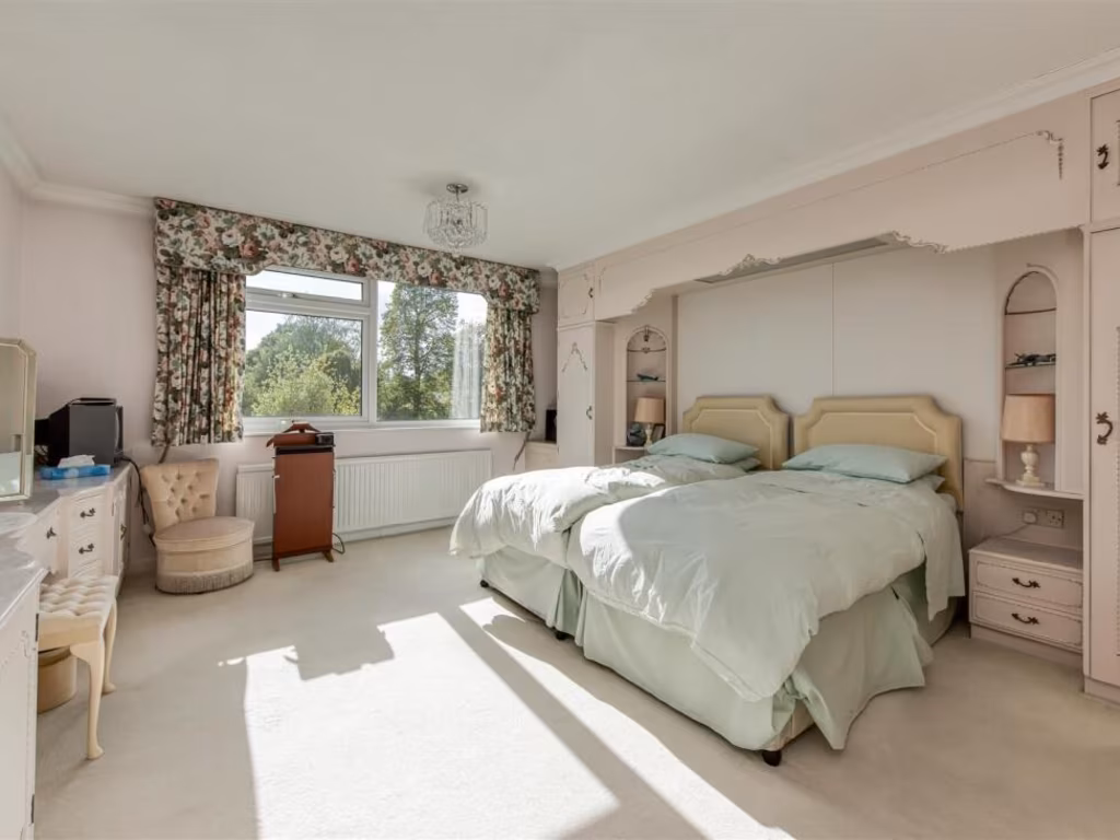
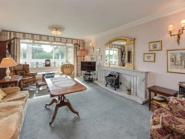
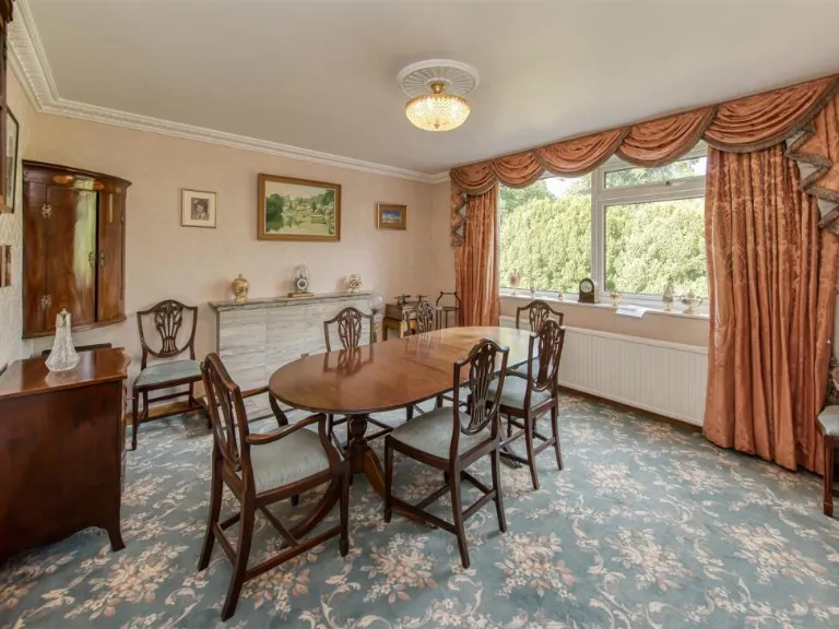
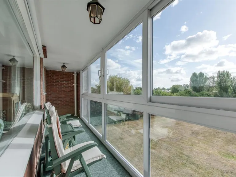
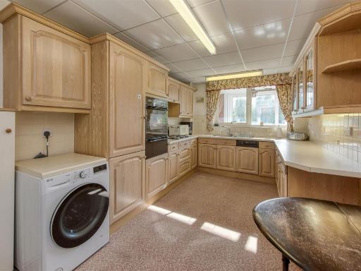
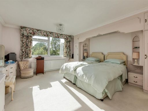
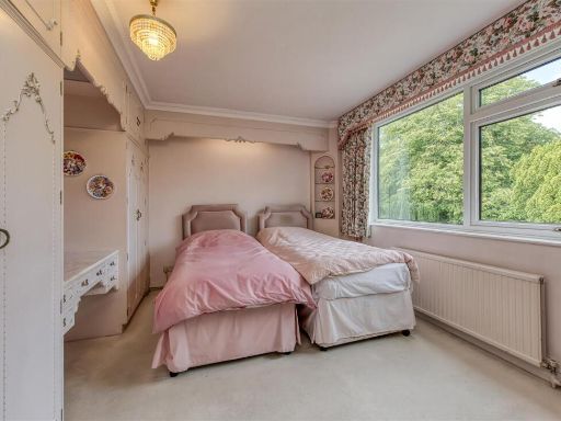
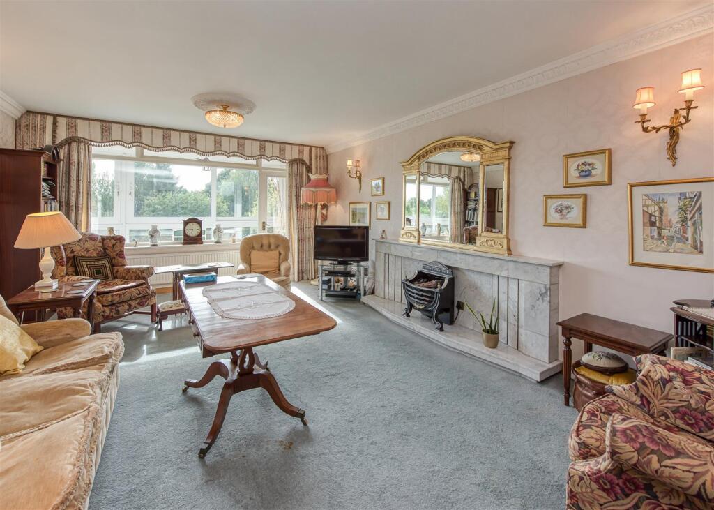
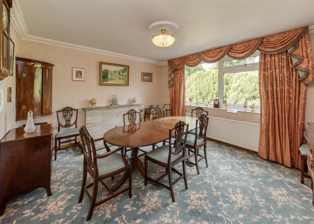
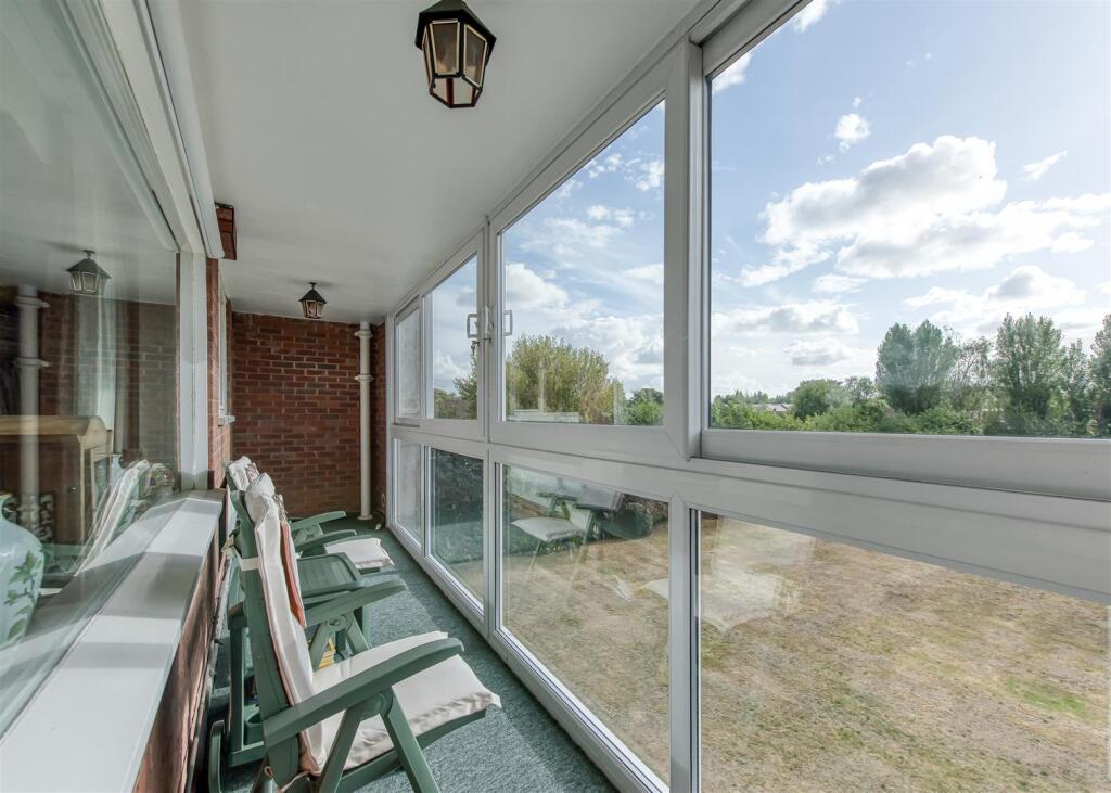
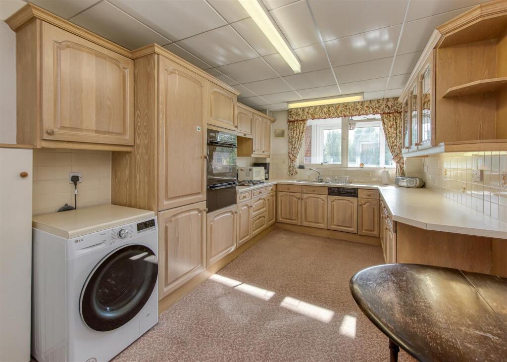
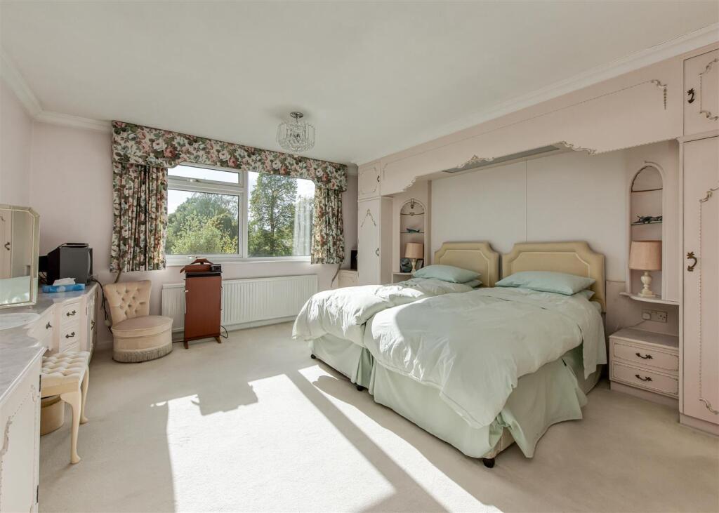
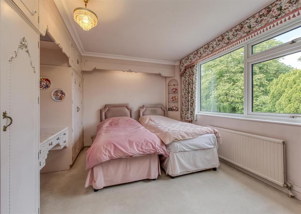
- Well-proportioned, traditionally finished apartment/flat occupying a single level (likely upper ground or first floor) with generous reception accommodation. The layout includes a large front living room with fireplace, a separate formal dining room, a fitted kitchen with integrated ovens and provision for laundry appliances, and a full-width glazed balcony/sunroom overlooking communal lawns and mature treelines. Decorative features are traditional — patterned carpeting, full-height drapery, plaster ceiling details and built-in storage. Light levels are good with large windows to front and rear elevations providing pleasant, private green outlooks. Garden/grounds visible from the balcony appear to be communal and of average size; overall the accommodation reads as spacious for an apartment and suitable for an older-style family or downsizer market. No precise floor area is shown.
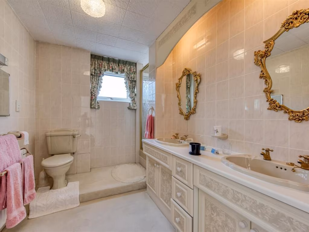
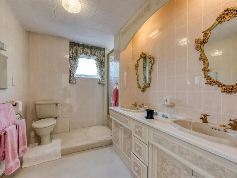
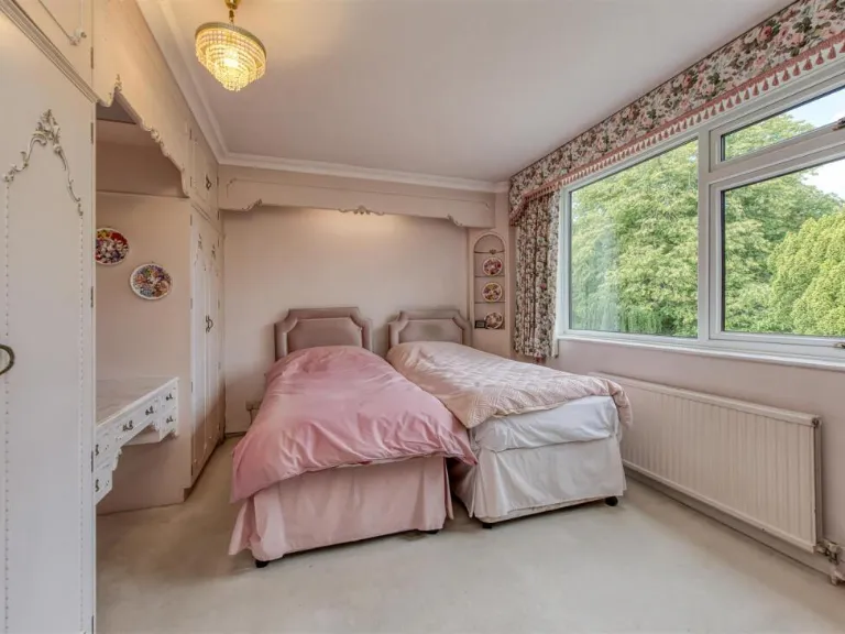
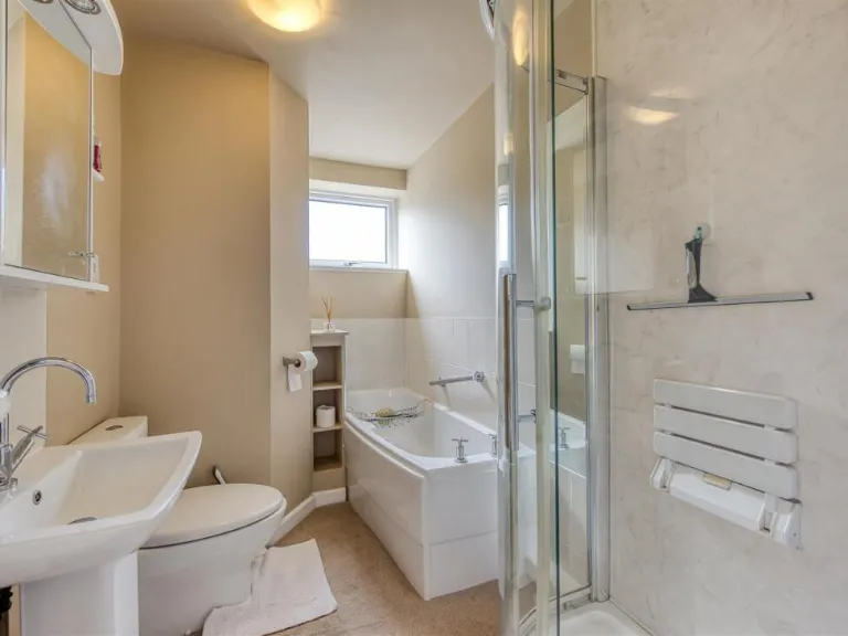
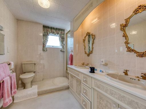
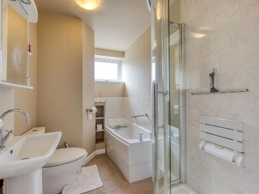
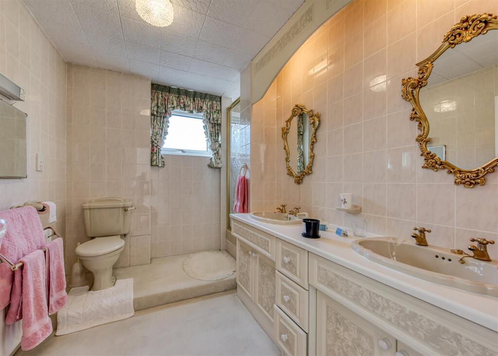
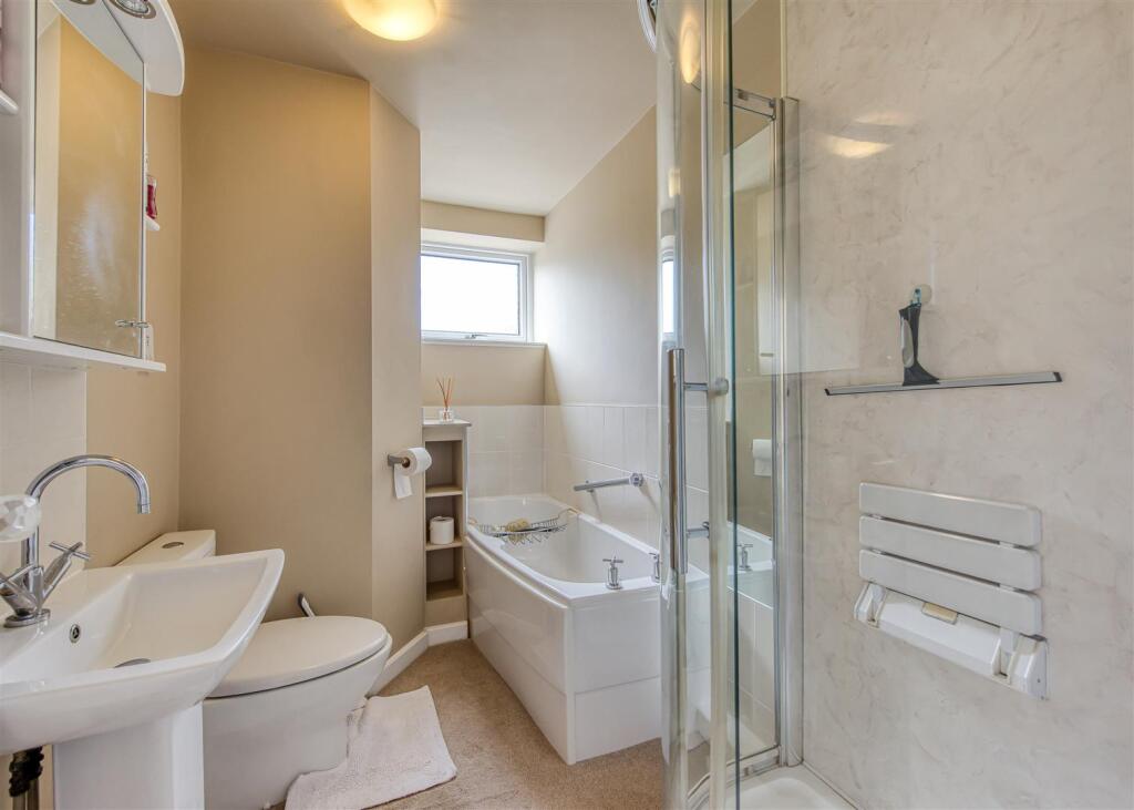
- Second-floor apartment in a purpose-built, gated development set within substantial, well‑stocked communal grounds. The property sits on a large, mature plot with private gardens and secure gated access. Accommodation (as described) comprises a principal double bedroom with en-suite, a second bedroom, a sitting/reception area, a dining/breakfast kitchen and ancillary rooms including storage and a utility/boiler cupboard. The apartment benefits from double glazing, secure off-street parking, garage parking and communal gardens. Layout and specification are consistent with a well-maintained, traditionally constructed apartment of average internal size for a two-bedroom flat. Overall condition appears good with scope for modest modernisation to personalise. Leasehold with a long lease (999 years from 24th June 1968), service charge circa £300 pcm and a nominal ground rent (£1 per annum).
Image Descriptions
- apartment block or flats Mid-20th Century Modernist
- residential apartment building Mid-century Modern
Floorplan Description
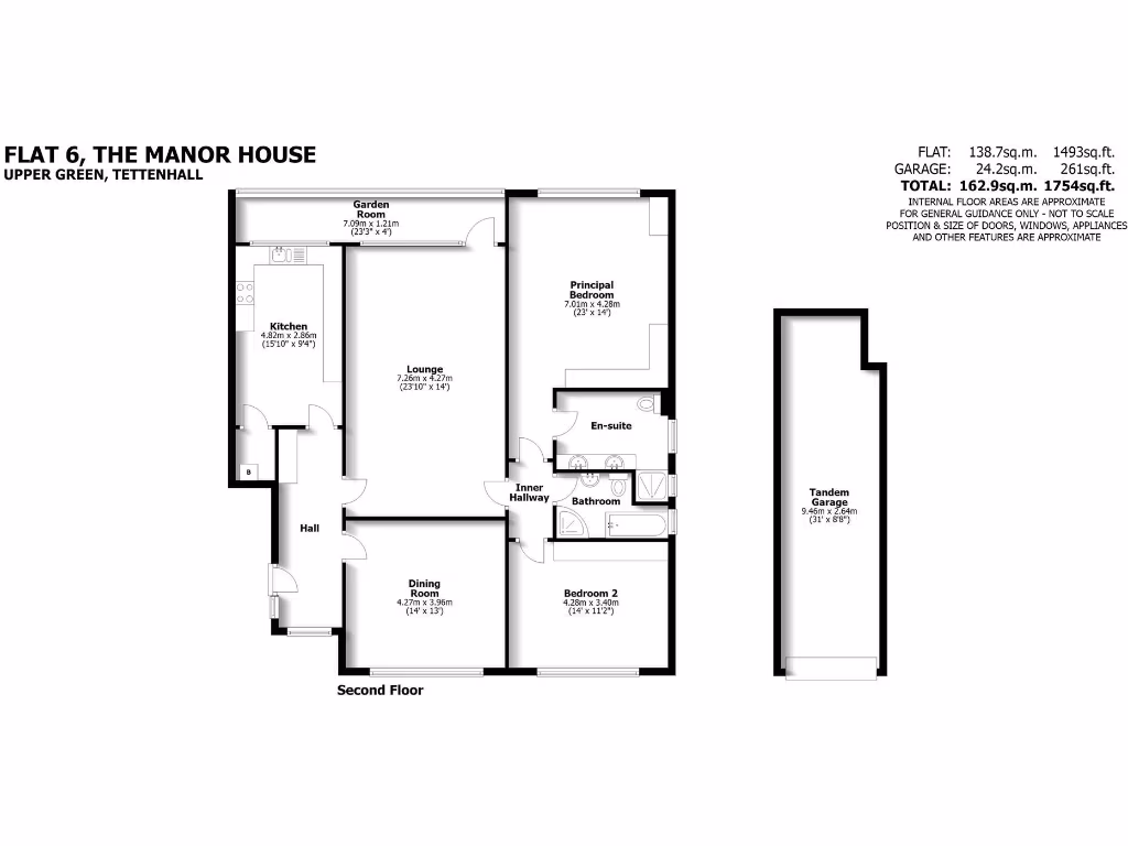
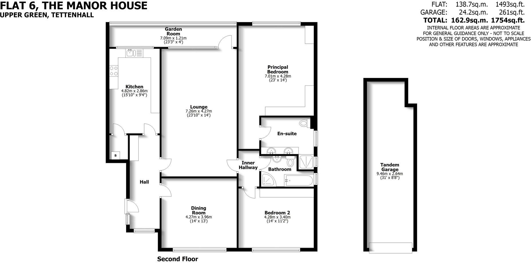
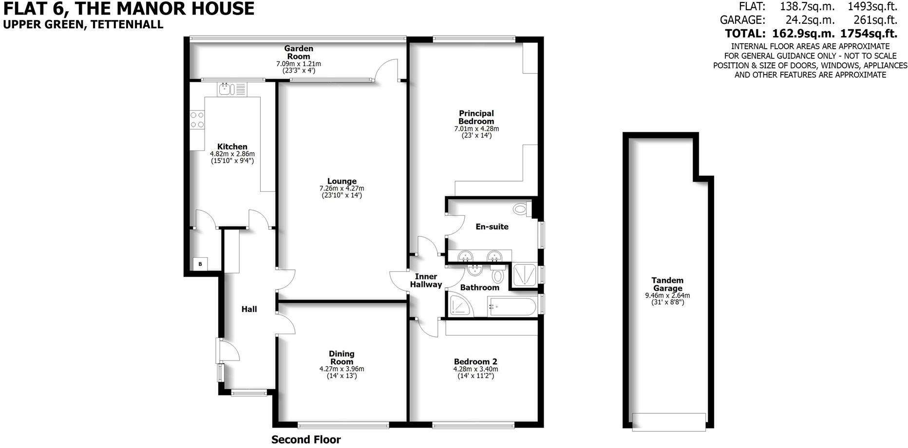
- Flat on Second Floor
- Flat on the Second Floor with lounge, kitchen, dining room, two bedrooms, garden room and bathrooms.
Rooms
- Garden Room:
- Kitchen:
- Lounge:
- Principal Bedroom:
- Dining Room:
- Bedroom 2:
- Garden Room:
- Kitchen:
- Lounge:
- Principal Bedroom:
- Dining Room:
- Bedroom 2:
Textual Property Features
Detected Visual Features
- apartment block
- modernist architecture
- brick building
- flat roof
- urban residential
- communal garden
- low-rise building
- apartment
- residential building
- brick facade
- mid-century modern
- flat units
- four floors
EPC Details
- Fully double glazed
- Cavity wall, filled cavity
- Boiler and radiators, mains gas
- Low energy lighting in 23% of fixed outlets
- (another dwelling below)
Nearby Schools
- Smestow Academy
- Wolverhampton Girls' High School
- Tettenhall College Incorporated
- SS Peter and Paul Catholic Primary Academy & Nursery
- Bhylls Acre Primary School
- Westacre Infant School
- St Peter's Collegiate Academy
- St Jude's Church of England Primary Academy
- Christ Church (Church of England) Infant and Nursery School
- St Edmund's Catholic Academy
- St Regis Church of England Academy
- St Michael's Church of England Aided Primary School
- Birches First School
- Castlecroft Primary School
- Wolverhampton Grammar School
- Newbridge Preparatory School
- Evergreen Academy
- Claregate Primary School
- Palmers Cross Primary School
- Dovecotes Primary School
- St Michael's Catholic Primary Academy and Nursery
- Uplands Junior School
- Christ Church (Church of England) Junior School
- St Andrew's Church of England Primary School
- Woodthorne Primary School
- Perton Middle School
- Aldersley High School
Nearest Bars And Restaurants
- Id: 969854125
- Tags:
- Amenity: restaurant
- Building: yes
- Cuisine: chinese
- Name: Minhs
- TagsNormalized:
- Lat: 52.5981253
- Lon: -2.1678176
- FullGeoHash: gcq7nxjqq1nn
- PartitionGeoHash: gcq7
- Images:
- FoodStandards: null
- Distance: 154.5
,- Id: 297321635
- Tags:
- Amenity: fast_food
- Building: yes
- Cuisine: fish_and_chips
- Name: The Village Plaice Fish & Chips
- Source: visual survey;bing
- TagsNormalized:
- Lat: 52.5980929
- Lon: -2.1678613
- FullGeoHash: gcq7nxjqj5jm
- PartitionGeoHash: gcq7
- Images:
- FoodStandards: null
- Distance: 153.4
,- Id: 558442978
- Tags:
- Addr:
- City: Wolverhampton
- Housenumber: 18
- Postcode: WV6 8QH
- Street: Upper Green
- Amenity: cafe
- Building: retail
- Name: Lime Tree Coffee
- Opening_hours: 09:00-17:00
- Source: survey
- TagsNormalized:
- Lat: 52.5989199
- Lon: -2.1677688
- FullGeoHash: gcq7nxm6zm66
- PartitionGeoHash: gcq7
- Images:
- FoodStandards: null
- Distance: 145.5
,- Id: 558440211
- Tags:
- Addr:
- City: Wolverhampton
- Housenumber: 4a
- Postcode: WV6 8QQ
- Street: Upper Green
- Amenity: restaurant
- Building: retail
- Level: 1
- Name: Monsoon
- Source: bing
- Website: http://www.monsoon.restaurant/home/
- TagsNormalized:
- Lat: 52.5980063
- Lon: -2.16887
- FullGeoHash: gcq7nxhttej3
- PartitionGeoHash: gcq7
- Images:
- FoodStandards: null
- Distance: 104.3
,- Id: 558435667
- Tags:
- Addr:
- City: Wolverhampton
- Housenumber: 2
- Postcode: WV6 8QQ
- Street: Upper Green
- Amenity: restaurant
- Building: retail
- Cuisine: italian
- Name: Cataldos Italian
- TagsNormalized:
- Lat: 52.5980304
- Lon: -2.1690134
- FullGeoHash: gcq7nxhtdrd2
- PartitionGeoHash: gcq7
- Images:
- FoodStandards: null
- Distance: 96
}
Nearest General Shops
- Id: 558440208
- Tags:
- Addr:
- City: Wolverhampton
- Housenumber: 5
- Postcode: WV6 8QQ
- Street: Upper Green
- Amenity: pharmacy
- Building: shop
- Healthcare: pharmacy
- Name: Upper Green Pharmacy
- TagsNormalized:
- pharmacy
- shop
- health
- healthcare
- Lat: 52.5981285
- Lon: -2.1687398
- FullGeoHash: gcq7nxhy29y3
- PartitionGeoHash: gcq7
- Images:
- FoodStandards: null
- Distance: 101.2
,- Id: 558327718
- Tags:
- Addr:
- City: Wolverhampton
- Housenumber: 23
- Postcode: WV6 8QZ
- Street: Limes Road
- Suburb: Tettenhall
- Building: office
- Name: Cabelo
- Shop: hairdresser
- Source: bing
- TagsNormalized:
- Lat: 52.5978343
- Lon: -2.1699425
- FullGeoHash: gcq7nx5usdvw
- PartitionGeoHash: gcq7
- Images:
- FoodStandards: null
- Distance: 97.2
,- Id: 558435665
- Tags:
- Addr:
- City: Wolverhampton
- Housenumber: 1
- Postcode: WV6 8QQ
- Street: Upper Green
- Building: retail
- Name: Baked in Tettenhall
- Shop: bakery
- Website: https://bakedit.co.uk
- TagsNormalized:
- Lat: 52.5980053
- Lon: -2.1691567
- FullGeoHash: gcq7nxhmwfze
- PartitionGeoHash: gcq7
- Images:
- FoodStandards: null
- Distance: 92.7
}
Nearest Grocery shops
- Id: 969854124
- Tags:
- Building: yes
- Name: Loco
- Shop: convenience
- TagsNormalized:
- Lat: 52.5980476
- Lon: -2.1678642
- FullGeoHash: gcq7nxjmv4er
- PartitionGeoHash: gcq7
- Images:
- FoodStandards: null
- Distance: 155.6
,- Id: 297321616
- Tags:
- Addr:
- City: Wolverhampton
- Housenumber: 8-9
- Postcode: WV6 8QQ
- Street: Upper Green
- Building: retail
- Description: Greengrocer and fresh fish
- Name: Jim Gough - Greengrocers
- Shop: greengrocer
- Source: visual survey; bing
- TagsNormalized:
- retail
- greengrocer
- grocer
- shop
- Lat: 52.5981742
- Lon: -2.1683939
- FullGeoHash: gcq7nxjn8f26
- PartitionGeoHash: gcq7
- Images:
- FoodStandards: null
- Distance: 117.5
,- Id: 558327719
- Tags:
- Addr:
- City: Wolverhampton
- Housenumber: 22
- Postcode: WV6 8QZ
- Street: Limes Road
- Suburb: Tettenhall
- Amenity: fast_food
- Building: shop
- Cuisine: fish_and_chips
- Name: Popin Fish & Chips
- Source: bing
- TagsNormalized:
- Lat: 52.5979297
- Lon: -2.1703583
- FullGeoHash: gcq7nx5t4uz8
- PartitionGeoHash: gcq7
- Images:
- FoodStandards: null
- Distance: 92
}
Nearest Supermarkets
- Id: 149004364
- Tags:
- Brand: Asda
- Brand:wikidata: Q297410
- Brand:wikipedia: en:Asda
- Building: yes
- Contact:
- Facebook: https://www.facebook.com/asda/
- Twitter: @asda
- Website: https://storelocator.asda.com/west-midlands/wolverhampton/molineux-way-waterloo-road
- Name: Asda
- Operator: Asda Stores Ltd
- Shop: supermarket
- Source: visual survey; bing
- Wheelchair: yes
- TagsNormalized:
- Lat: 52.5925328
- Lon: -2.1286558
- FullGeoHash: gcq7pw1vwwxn
- PartitionGeoHash: gcq7
- Images:
- FoodStandards: null
- Distance: 2868.8
,- Id: 85948546
- Tags:
- Brand: Sainsbury's
- Brand:wikidata: Q152096
- Brand:wikipedia: en:Sainsbury's
- Building: retail
- Name: Sainsbury's
- Shop: supermarket
- TagsNormalized:
- sainsburys
- retail
- supermarket
- shop
- Lat: 52.5951443
- Lon: -2.2020921
- FullGeoHash: gcq7jyskzt90
- PartitionGeoHash: gcq7
- Images:
- FoodStandards: null
- Distance: 2210.5
,- Id: 297417224
- Tags:
- Addr:
- Country: GB
- Postcode: WV3 9EN
- Street: Finchfield Hill
- Brand: Lidl
- Brand:wikidata: Q151954
- Brand:wikipedia: en:Lidl
- Building: retail
- Fhrs:
- Name: Lidl
- Shop: supermarket
- Source: bing
- TagsNormalized:
- lidl
- retail
- supermarket
- shop
- Lat: 52.5809201
- Lon: -2.1725114
- FullGeoHash: gcq7ns440cfj
- PartitionGeoHash: gcq7
- Images:
- FoodStandards:
- Id: 784446
- FHRSID: 784446
- LocalAuthorityBusinessID: 30035
- BusinessName: Lidl
- BusinessType: Retailers - supermarkets/hypermarkets
- BusinessTypeID: 7840
- AddressLine1: Finchfield Hill
- AddressLine2: Wolverhampton
- AddressLine3: West Midlands
- AddressLine4: null
- PostCode: WV3 9EN
- RatingValue: 5
- RatingKey: fhrs_5_en-GB
- RatingDate: 2018-12-04
- LocalAuthorityCode: 436
- LocalAuthorityName: Wolverhampton
- LocalAuthorityWebSite: http://www.wolverhampton.gov.uk/
- LocalAuthorityEmailAddress: customer.services@wolverhampton.gov.uk
- Scores:
- Hygiene: 0
- Structural: 5
- ConfidenceInManagement: 0
- NewRatingPending: false
- Geocode:
- Longitude: -2.17217000000000
- Latitude: 52.58201500000000
- Distance: 1985.8
}
Nearest Religious buildings
- Id: 43157347
- Tags:
- Addr:
- City: Tettenhall
- Housename: St. Michael's School
- Postcode: WV6 9AF
- Street: Lower Street
- Amenity: school
- Capacity: 210
- Denomination: anglican
- Diocese: Diocese of Lichfield
- Isced:
- Max_age: 11
- Min_age: 5
- Name: St Michael's Church of England Aided Primary School
- Phone: +44 1902 558845
- Ref:
- Religion: christian
- School:
- Boarding: no
- Gender: mixed
- Selective: no
- Trust: no
- Type: voluntary_aided
- Website: https://www.stmichaelscofeprimary.co.uk/
- TagsNormalized:
- school
- anglican
- church
- christian
- Lat: 52.598001
- Lon: -2.1607366
- FullGeoHash: gcq7nz4te4n1
- PartitionGeoHash: gcq7
- Images:
- FoodStandards: null
- Distance: 623.5
,- Id: 207483033
- Tags:
- Amenity: place_of_worship
- Building: church
- Denomination: anglican
- Heritage: 2
- Heritage:operator: Historic England
- Listed_status: Grade II
- Name: Saint Michael and All Angels
- Religion: christian
- Wikidata: Q26497493
- TagsNormalized:
- place of worship
- church
- anglican
- christian
- Lat: 52.6003456
- Lon: -2.1619595
- FullGeoHash: gcq7nz9enxn5
- PartitionGeoHash: gcq7
- Images:
- FoodStandards: null
- Distance: 566
,- Id: 297315043
- Tags:
- Amenity: place_of_worship
- Building: church
- Denomination: catholic
- Name: St Thomas of Canterbury Catholic Church
- Religion: christian
- TagsNormalized:
- place of worship
- church
- catholic
- christian
- Lat: 52.5960858
- Lon: -2.1698887
- FullGeoHash: gcq7nwgfmvj8
- PartitionGeoHash: gcq7
- Images:
- FoodStandards: null
- Distance: 291.5
}
Nearest Medical buildings
- Id: 880536839
- Tags:
- Addr:
- Housenumber: 12
- Street: School Road
- Amenity: pharmacy
- Building: yes
- Dispensing: yes
- Healthcare: pharmacy
- Name: Tettenhall Wood Pharmacy
- TagsNormalized:
- pharmacy
- health
- healthcare
- wood
- Lat: 52.5908127
- Lon: -2.1821385
- FullGeoHash: gcq7nmg58qp9
- PartitionGeoHash: gcq7
- Images:
- FoodStandards: null
- Distance: 1206.1
,- Id: 297323970
- Tags:
- Addr:
- City: Wolverhampton
- Housenumber: 255
- Postcode: WV6 0DE
- Street: Tettenhall Road
- Amenity: doctors
- Building: yes
- Healthcare: doctor
- Name: Newbridge Surgery
- Source: bing
- TagsNormalized:
- doctor
- doctors
- health
- healthcare
- surgery
- Lat: 52.5942563
- Lon: -2.1561136
- FullGeoHash: gcq7nymzwzvp
- PartitionGeoHash: gcq7
- Images:
- FoodStandards: null
- Distance: 1054.2
,- Id: 209816607
- Tags:
- Amenity: doctors
- Building: yes
- Healthcare: doctor
- Name: Lower Green Medical Practice
- TagsNormalized:
- doctor
- doctors
- health
- healthcare
- Lat: 52.6007045
- Lon: -2.1596319
- FullGeoHash: gcq7nzemkfj8
- PartitionGeoHash: gcq7
- Images:
- FoodStandards: null
- Distance: 727.8
,- Id: 207500419
- Tags:
- Addr:
- City: Tettenhall
- Housename: Rock House
- Postcode: WV6 8QA
- Street: The Rock
- Amenity: dentist
- Building: yes
- Healthcare: dentist
- Name: Rock House Dental Practice
- TagsNormalized:
- dentist
- health
- healthcare
- dental
- Lat: 52.5985462
- Lon: -2.1643208
- FullGeoHash: gcq7nxrbxxtm
- PartitionGeoHash: gcq7
- Images:
- FoodStandards: null
- Distance: 376.9
}
Nearest Leisure Facilities
- Id: 868882870
- Tags:
- Leisure: pitch
- Sport: tennis
- TagsNormalized:
- Lat: 52.6028283
- Lon: -2.1695892
- FullGeoHash: gcq7q8h1svvj
- PartitionGeoHash: gcq7
- Images:
- FoodStandards: null
- Distance: 458.7
,- Id: 112677795
- Tags:
- TagsNormalized:
- Lat: 52.5957895
- Lon: -2.1651144
- FullGeoHash: gcq7nwz2tjv9
- PartitionGeoHash: gcq7
- Images:
- FoodStandards: null
- Distance: 457.8
,- Id: 868882866
- Tags:
- Leisure: pitch
- Sport: cricket
- TagsNormalized:
- pitch
- leisure
- cricket
- sports
- Lat: 52.6025488
- Lon: -2.1712487
- FullGeoHash: gcq7q84bn1zd
- PartitionGeoHash: gcq7
- Images:
- FoodStandards: null
- Distance: 436.8
,- Id: 129110434
- Tags:
- Leisure: park
- Name: Tettenhall Green
- TagsNormalized:
- Lat: 52.6010774
- Lon: -2.1700667
- FullGeoHash: gcq7nxez3z8b
- PartitionGeoHash: gcq7
- Images:
- FoodStandards: null
- Distance: 263.8
,- Id: 709828932
- Tags:
- Leisure: pitch
- Name: Tettenhall
- Sport: bowls
- TagsNormalized:
- Lat: 52.5977955
- Lon: -2.1714899
- FullGeoHash: gcq7nx4u2eez
- PartitionGeoHash: gcq7
- Images:
- FoodStandards: null
- Distance: 148
}
Nearest Tourist attractions
- Id: 296216299
- Tags:
- Addr:
- City: Wolverhampton
- Housename: Revelstoke
- Housenumber: 124
- Postcode: WV6 0BL
- Street: Tettenhall Road
- Building: residential
- Name: Revelstoke Guest House
- Source: bing
- Tourism: guest_house
- TagsNormalized:
- residential
- guest house
- tourism
- Lat: 52.5936736
- Lon: -2.1542505
- FullGeoHash: gcq7nyrk6767
- PartitionGeoHash: gcq7
- Images:
- FoodStandards: null
- Distance: 1195.8
,- Id: 405379954
- Tags:
- Addr:
- Building: yes
- Name: Tettenhall Transport Heritage Museum
- Tourism: museum
- TagsNormalized:
- Lat: 52.5966433
- Lon: -2.1623822
- FullGeoHash: gcq7nycmsufy
- PartitionGeoHash: gcq7
- Images:
- FoodStandards: null
- Distance: 556.9
,- Id: 129109140
- Tags:
- Name: Tettenhall Paddling Pool
- Natural: water
- Tourism: attraction
- TagsNormalized:
- paddling pool
- pool
- water
- attraction
- tourism
- Lat: 52.5998064
- Lon: -2.1685086
- FullGeoHash: gcq7nxsbn4dg
- PartitionGeoHash: gcq7
- Images:
- FoodStandards: null
- Distance: 153.9
}
Nearest Train stations
- Id: 8183358952
- Tags:
- Name: Coseley
- Naptan:
- Network: National Rail
- Public_transport: station
- Railway: station
- Ref:
- West_midlands_fare_zone: 5
- Wikidata: Q2239840
- Wikipedia: en:Coseley railway station
- TagsNormalized:
- Lat: 52.5453191
- Lon: -2.0858098
- FullGeoHash: gcqdbt94tj7m
- PartitionGeoHash: gcqd
- Images:
- FoodStandards: null
- Distance: 8217.9
,- Id: 3711941416
- Tags:
- Name: Albrighton
- Naptan:
- Network: National Rail
- Public_transport: station
- Railway: station
- Ref:
- Wikidata: Q2943712
- Wikipedia: en:Albrighton railway station
- TagsNormalized:
- Lat: 52.6382346
- Lon: -2.2692137
- FullGeoHash: gcq7kq7xgqps
- PartitionGeoHash: gcq7
- Images:
- FoodStandards: null
- Distance: 8017.1
,- Id: 3711941418
- Tags:
- Name: Codsall
- Naptan:
- Network: National Rail
- Public_transport: station
- Railway: station
- Ref:
- Wikidata: Q2455479
- Wikipedia: en:Codsall railway station
- TagsNormalized:
- Lat: 52.6274199
- Lon: -2.2016755
- FullGeoHash: gcq7musbcnpg
- PartitionGeoHash: gcq7
- Images:
- FoodStandards: null
- Distance: 3846.7
,- Id: 6634567442
- Tags:
- Name: Wolverhampton
- Naptan:
- Network: National Rail
- Old_name: Wolverhampton High Level
- Public_transport: station
- Railway: station
- Ref:
- West_midlands_fare_zone: 5
- Wheelchair: yes
- Wikidata: Q2361188
- Wikipedia: en:Wolverhampton railway station
- TagsNormalized:
- Lat: 52.5879884
- Lon: -2.120242
- FullGeoHash: gcq7pv254z8c
- PartitionGeoHash: gcq7
- Images:
- FoodStandards: null
- Distance: 3559.4
,- Id: 3711941417
- Tags:
- Name: Bilbrook
- Naptan:
- Network: National Rail
- Public_transport: station
- Railway: station
- Ref:
- Wikidata: Q2786231
- Wikipedia: en:Bilbrook railway station
- TagsNormalized:
- Lat: 52.6239645
- Lon: -2.1873052
- FullGeoHash: gcq7q5zkb1gp
- PartitionGeoHash: gcq7
- Images:
- FoodStandards: null
- Distance: 3044.5
}
Nearest Hotels
- Id: 559226584
- Tags:
- Addr:
- City: Wolverhampton
- Housenumber: 77-79
- Postcode: WV6 0AG
- Street: Albert Road
- Name: Queen Victoria Hotel
- Tourism: hotel
- Website: https://www.thequeenvictoriahotel.co.uk
- TagsNormalized:
- Lat: 52.5908181
- Lon: -2.1502067
- FullGeoHash: gcq7pjf78x19
- PartitionGeoHash: gcq7
- Images:
- FoodStandards: null
- Distance: 1593.1
,- Id: 10591430705
- Tags:
- Name: Harwin Hotel
- Tourism: hotel
- TagsNormalized:
- Lat: 52.6066084
- Lon: -2.1527101
- FullGeoHash: gcq7r08rwnx4
- PartitionGeoHash: gcq7
- Images:
- FoodStandards: null
- Distance: 1455.6
,- Id: 296216290
- Tags:
- Addr:
- City: Wolverhampton
- Housenumber: 138
- Postcode: WV6 0BQ
- Street: Tettenhall Road
- Bar: yes
- Building: yes
- Name: The York Hotel
- Restaurant: yes
- Source: bing
- Tourism: hotel
- Website: http://theyorkhotel.com
- TagsNormalized:
- Lat: 52.5946157
- Lon: -2.1553424
- FullGeoHash: gcq7nyw9bfup
- PartitionGeoHash: gcq7
- Images:
- FoodStandards: null
- Distance: 1083.1
}
Tags
- apartment block
- modernist architecture
- brick building
- flat roof
- urban residential
- communal garden
- low-rise building
- apartment
- residential building
- brick facade
- mid-century modern
- flat units
- communal garden
- four floors
Local Market Stats
- Average Price/sqft: £253
- Avg Income: £43000
- Rental Yield: 3.7%
- Social Housing: 5%
- Planning Success Rate: 89%
AirBnB Data
- 1km average: £76/night
- Listings in 1km: 2
Similar Properties
 2 bedroom apartment for sale in High Street, Tettenhall, Wolverhampton, WV6 — £325,000 • 2 bed • 2 bath • 924 ft²
 3 bedroom flat for sale in Lower Green, Tettenhall, Wolverhampton, WV6 — £345,000 • 3 bed • 2 bath • 910 ft²
 2 bedroom maisonette for sale in Clifton Road STOCKWELL END, WV6 — £275,000 • 2 bed • 1 bath • 826 ft²
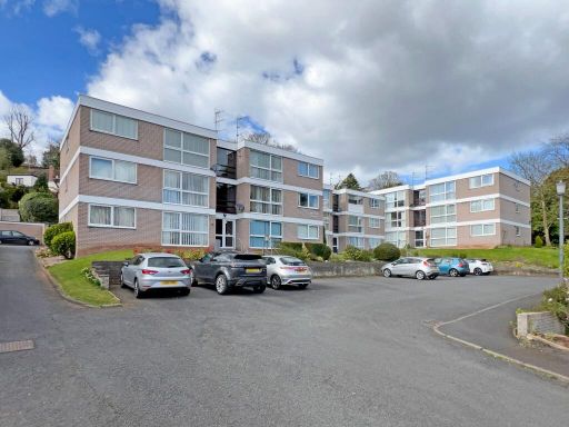 2 bedroom flat for sale in Woodfield Heights, Tettenhall, WV6 — £175,000 • 2 bed • 1 bath • 531 ft²
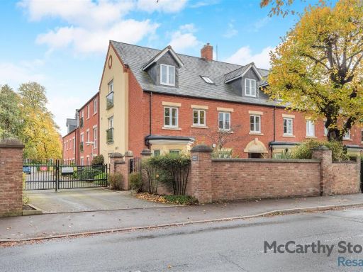 2 bedroom apartment for sale in Bluebell Court, High Street, Tettenhall, Wolverhampton, WV6 — £285,000 • 2 bed • 2 bath • 883 ft²
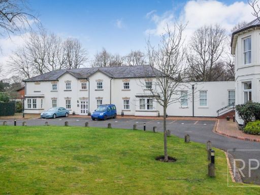 2 bedroom flat for sale in Edward Lisle Gardens, Tettenhall, Wolverhampton, WV6 — £239,950 • 2 bed • 1 bath
Meta
- {
"@context": "https://schema.org",
"@type": "Residence",
"name": "2 bedroom flat for sale in Flat 6, The Manor House, Upper G…",
"description": "",
"url": "https://propertypiper.co.uk/property/4ae3894e-ff65-4fd1-88b3-dcca96e5d56d",
"image": "https://image-a.propertypiper.co.uk/a41f044f-fcd6-4122-bddc-17a2fbe10423-1024.jpeg",
"address": {
"@type": "PostalAddress",
"streetAddress": "THE MANOR HOUSE 6 UPPER GREEN WOLVERHAMPTON ",
"postalCode": "WV6 8QJ",
"addressLocality": "Wolverhampton",
"addressRegion": "Wolverhampton South West",
"addressCountry": "England"
},
"geo": {
"@type": "GeoCoordinates",
"latitude": 52.5987076,
"longitude": -2.1698949
},
"numberOfRooms": 2,
"numberOfBathroomsTotal": 2,
"floorSize": {
"@type": "QuantitativeValue",
"value": 1493,
"unitCode": "FTK"
},
"offers": {
"@type": "Offer",
"price": 499950,
"priceCurrency": "GBP",
"availability": "https://schema.org/InStock"
},
"additionalProperty": [
{
"@type": "PropertyValue",
"name": "Feature",
"value": "apartment block"
},
{
"@type": "PropertyValue",
"name": "Feature",
"value": "modernist architecture"
},
{
"@type": "PropertyValue",
"name": "Feature",
"value": "brick building"
},
{
"@type": "PropertyValue",
"name": "Feature",
"value": "flat roof"
},
{
"@type": "PropertyValue",
"name": "Feature",
"value": "urban residential"
},
{
"@type": "PropertyValue",
"name": "Feature",
"value": "communal garden"
},
{
"@type": "PropertyValue",
"name": "Feature",
"value": "low-rise building"
},
{
"@type": "PropertyValue",
"name": "Feature",
"value": "apartment"
},
{
"@type": "PropertyValue",
"name": "Feature",
"value": "residential building"
},
{
"@type": "PropertyValue",
"name": "Feature",
"value": "brick facade"
},
{
"@type": "PropertyValue",
"name": "Feature",
"value": "mid-century modern"
},
{
"@type": "PropertyValue",
"name": "Feature",
"value": "flat units"
},
{
"@type": "PropertyValue",
"name": "Feature",
"value": "communal garden"
},
{
"@type": "PropertyValue",
"name": "Feature",
"value": "four floors"
}
]
}
High Res Floorplan Images
Compatible Floorplan Images
FloorplanImages Thumbnail