N19 3RR - 1 bedroom flat for sale in St. John's Way, London, N19
View on Property Piper
1 bedroom flat for sale in St. John's Way, London, N19
Property Details
- Price: £400000
- Bedrooms: 1
- Bathrooms: 1
- Property Type: undefined
- Property SubType: undefined
Brochure Descriptions
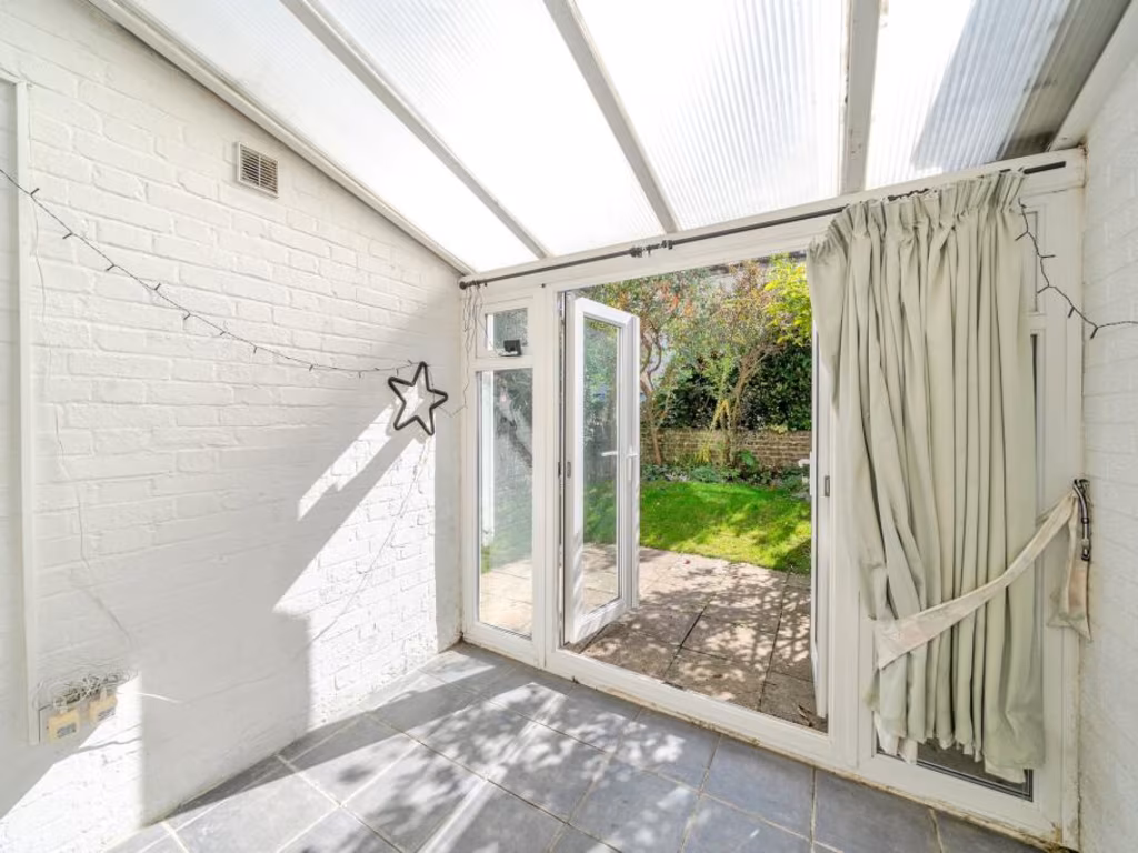
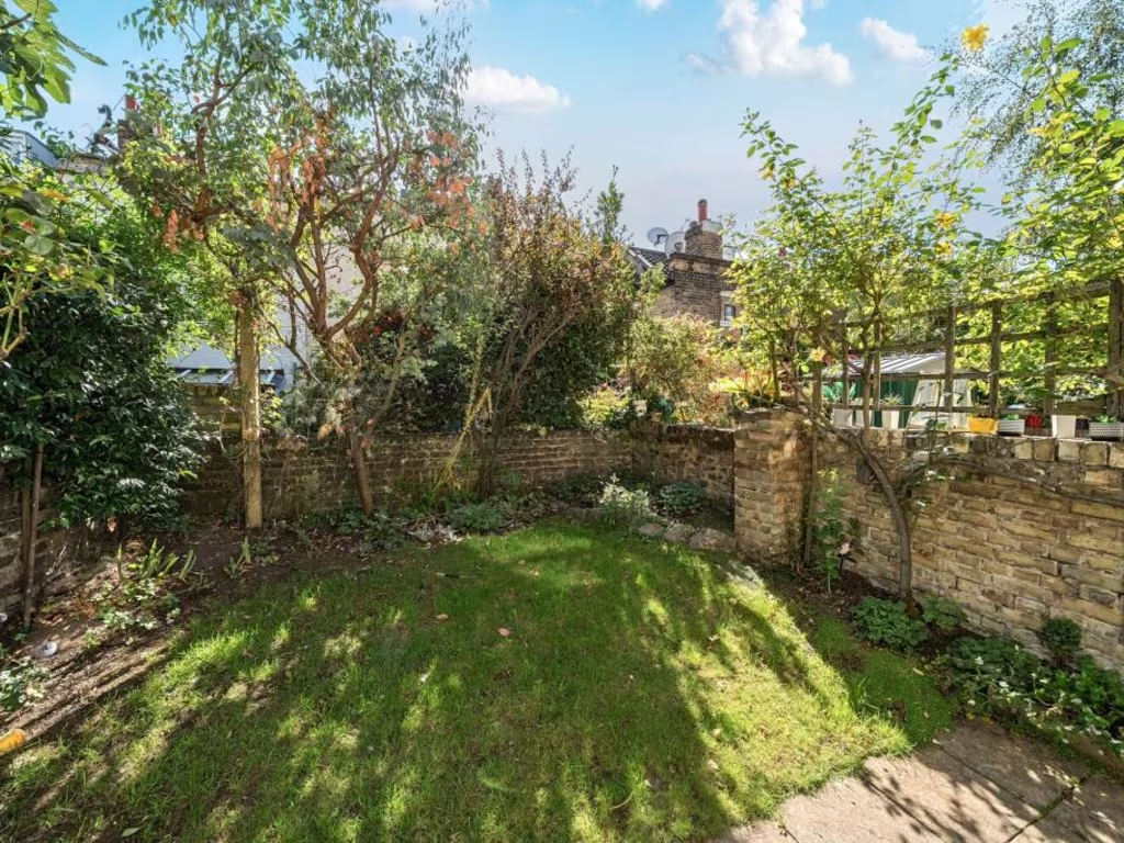
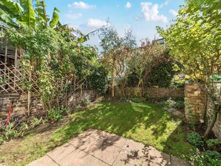
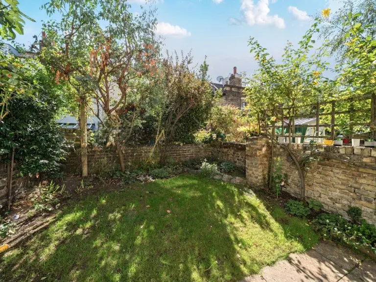
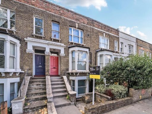
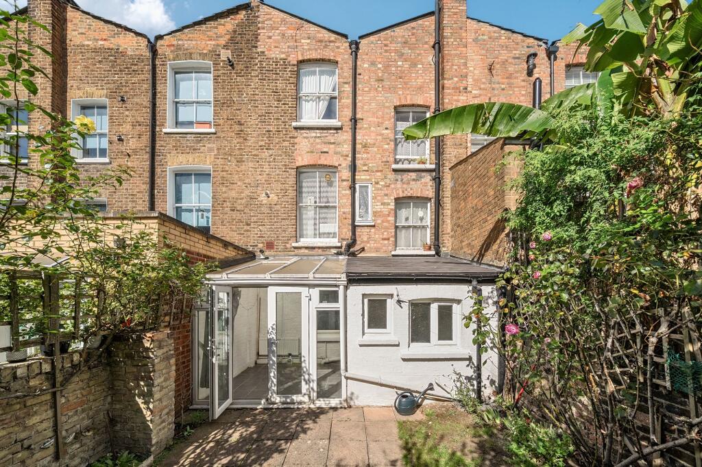
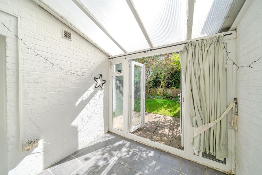
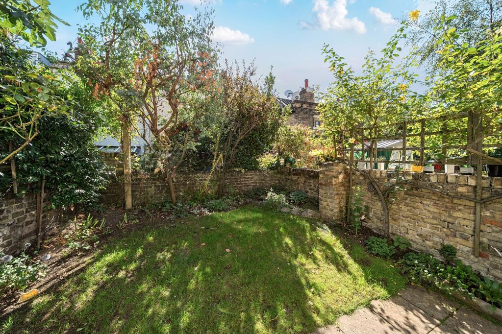
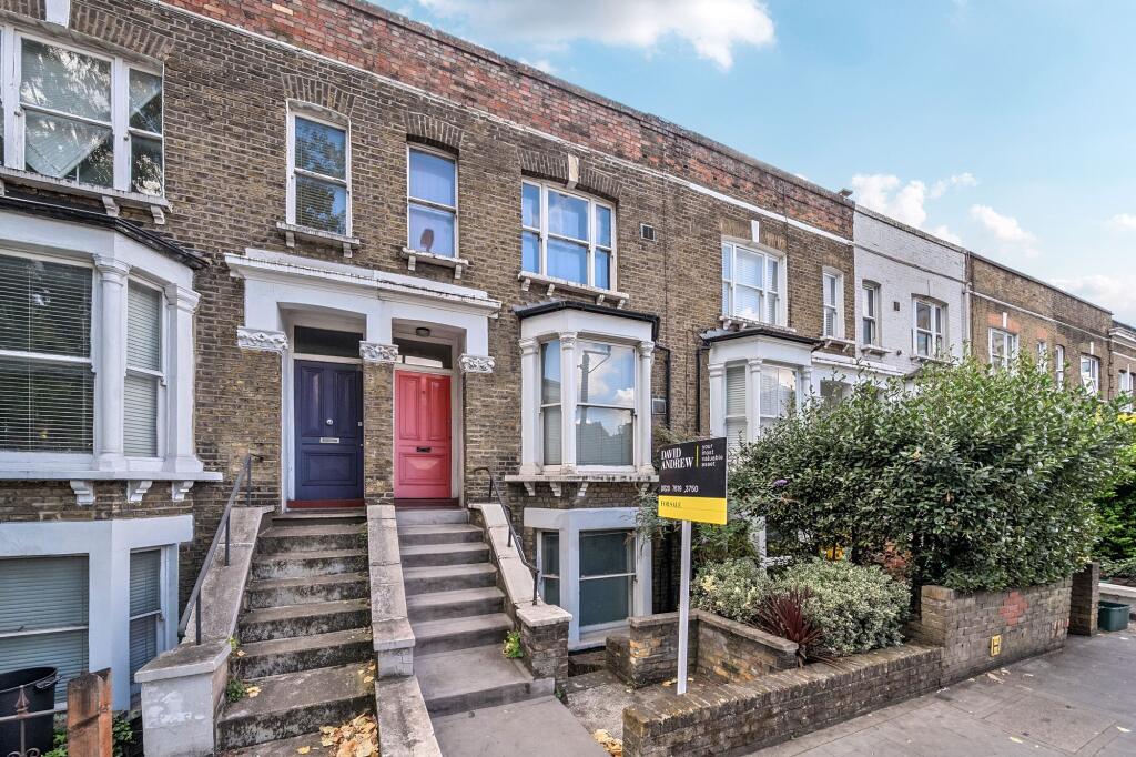
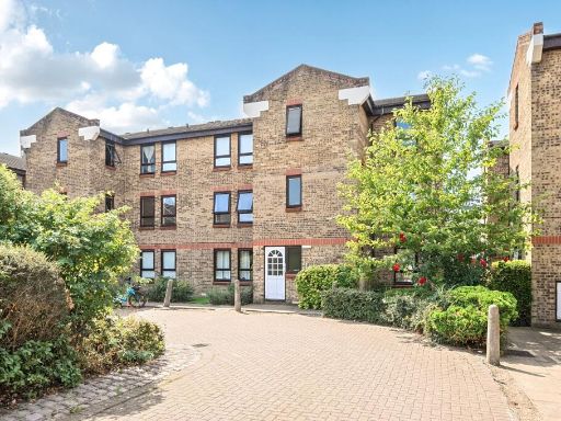
- Rear elevation of a basement floor flat within a Victorian/Georgian style terraced brick building. The property has a single-storey rear extension with glazed doors (conservatory/lean-to) leading onto a small paved courtyard garden with planted borders and trellis — a compact outdoor space typical for a central-London terrace. Windows indicate a lower-ground accommodation level with access up to the main garden level. Construction and period features suggest solid brick party walls and sash-style openings above. Overall the flat appears to be small to average in internal footprint (typical basement one- to two-bedroom city flat) with a small private garden; a practical central-London property suitable for first-time buyers or investors. No internal condition beyond the visible rear extension can be confirmed from the image.
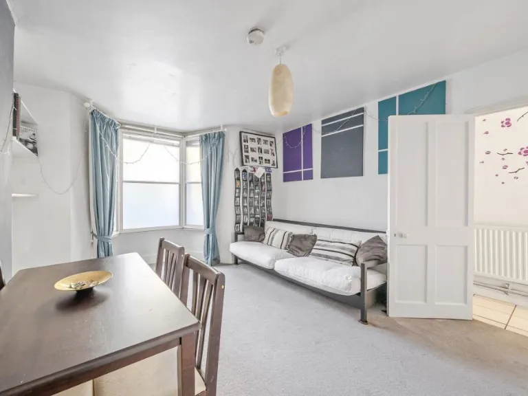
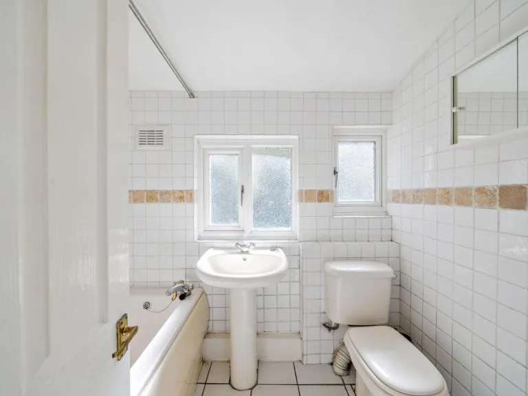
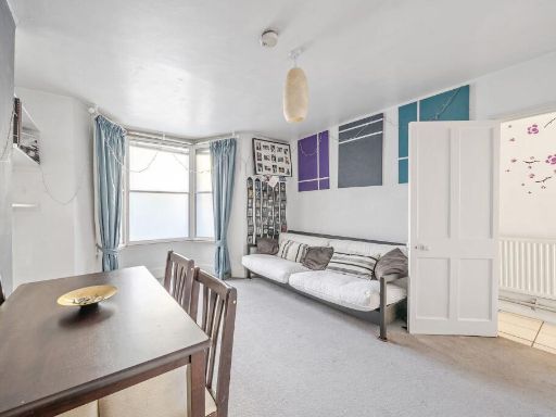
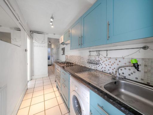
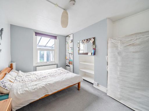
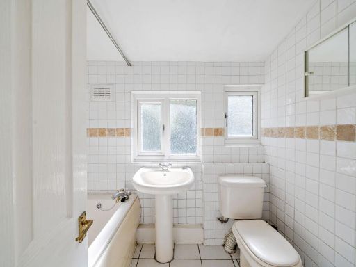
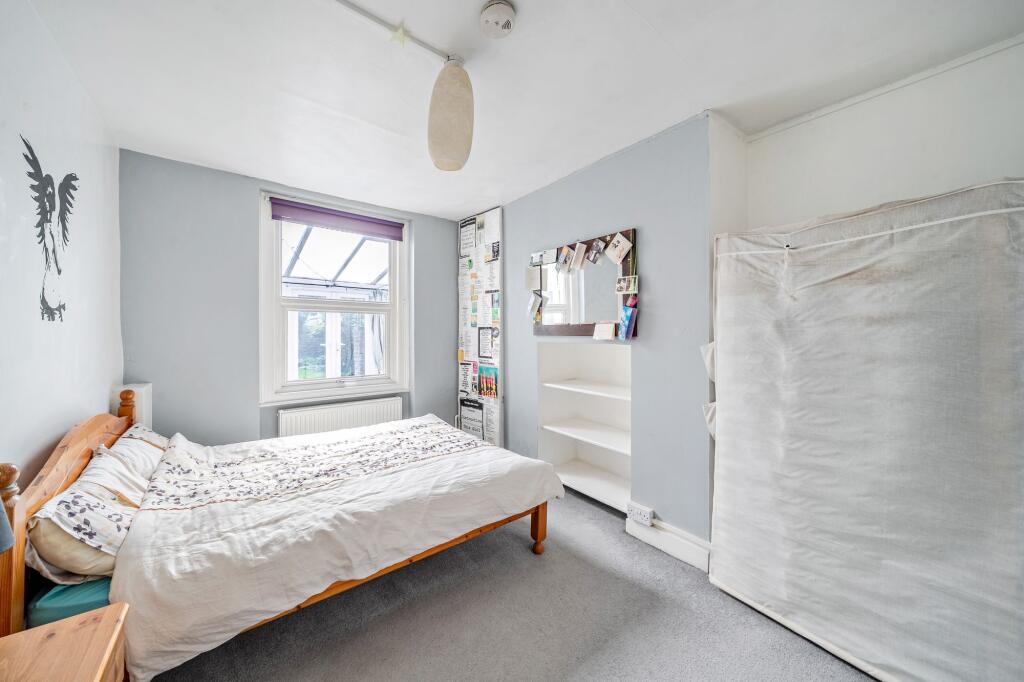
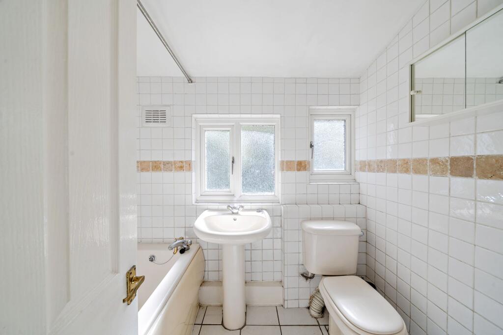
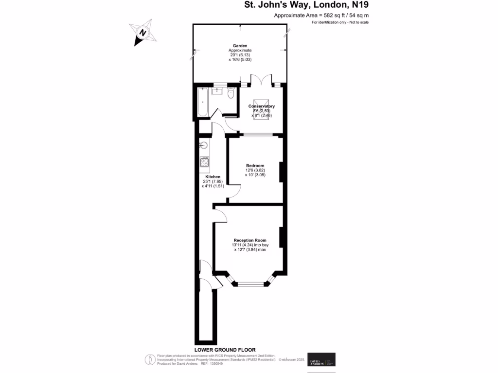
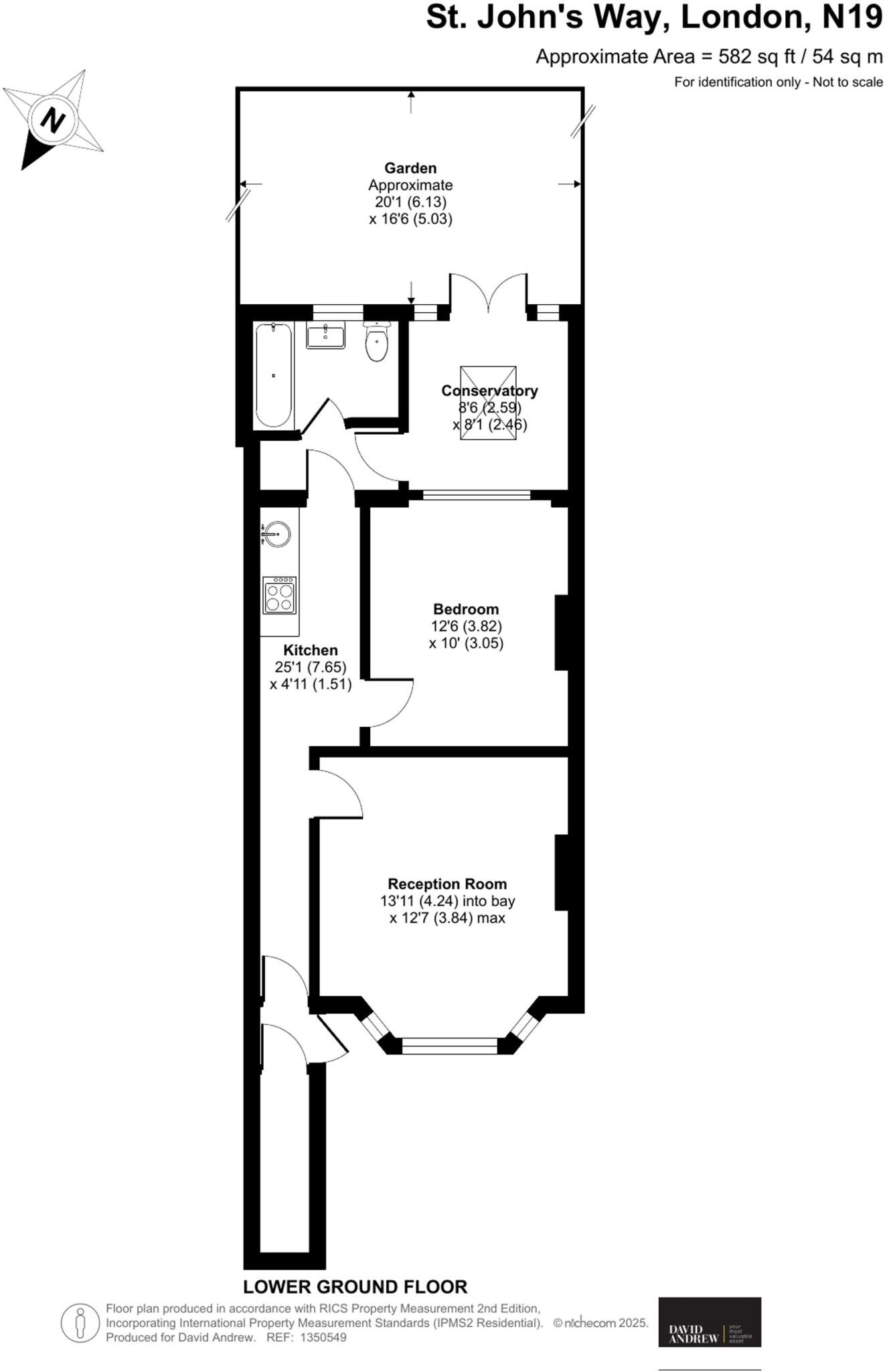
- Lower-ground flat arranged over approximately 582 sq ft (54 sq m) with a private garden. The accommodation comprises a front reception room with bay, one double bedroom, a fitted kitchen, bathroom and a rear conservatory leading to a garden (approx 20'1" x 16'6"). Overall the property is a compact, well-proportioned one-bedroom unit suited to a single occupant or couple. Garden is a notable asset for this level of stock. The layout and footprint suggest average internal room sizes for an inner-London lower-ground conversion; overall plot and living area are small-to-average for family use but attractive for rental/investment given outside space and location in N19.
- Lower-ground (basement) floor period flat presented chain-free. Approximately 582 sq ft (54 sqm) offering one spacious double bedroom, bright reception room, separate kitchen, bathroom, a large conservatory and a generous private rear garden. Property benefits from its own private entrance and good natural light to principal rooms. Located a short walk from Archway Underground (Northern line) and Upper Holloway Overground with close access to green spaces including Whittington Park and Waterlow Park. Overall the flat is well-proportioned for its size with good storage, strong rental/owner-occupier appeal for buyers seeking a garden and transport links; condition appears clean and lettable though modernisation to kitchen/bathroom or cosmetic updating could increase value.
Image Descriptions
- Victorian terraced house Victorian
- garden
Floorplan Description
- Lower ground floor flat with reception room, bedroom, kitchen and conservatory (garden excluded).
Rooms
- Reception Room:
- Bedroom:
- Kitchen:
- Conservatory:
Textual Property Features
- Has Garden
- Chain Free
- Success
Detected Visual Features
- Victorian
- terraced house
- brickwork
- period
- high ceilings
- garden
- outdoor space
- landscaped
- greenery
- privacy
- trees
- stone paving
- lawn
Nearby Schools
- Beacon High
- St John's Upper Holloway CofE Primary School
- Arts and Media School Islington
- Channing School
- Coleridge Primary School
- Torriano Primary School
- Kentish Town Church of England Primary School
- Tufnell Park Primary School
- Eleanor Palmer Primary School
- Acland Burghley School
- City of London Academy, Highgate Hill
- The Avenue Pre-Preparatory School and Nursery
- Highgate Wood Secondary School
- Grafton Primary School
- Wildwood Nature School
- Yerbury Primary School
- St Mark's CofE Primary School
- St Joseph's Catholic Primary School
- Whitehall Park School
- St Peter-in-Chains RC Infant School
- La Sainte Union Catholic Secondary School
- Brookfield Primary School
- Hargrave Park Primary School
- Duncombe Primary School
- St Aloysius RC College
- Highgate School
- Ashmount Primary School
- St Gildas' Catholic Junior School
Nearest Bars And Restaurants
- Id: 76586528
- Tags:
- Addr:
- Housenumber: 1
- Postcode: N19 5QT
- Street: Junction Road
- Amenity: cafe
- Brand: Starbucks
- Brand:wikidata: Q37158
- Building: yes
- Former_name: The Lion
- Name: Starbucks
- TagsNormalized:
- Lat: 51.5653226
- Lon: -0.1343243
- FullGeoHash: gcpvkgnjy0bd
- PartitionGeoHash: gcpv
- Images:
- FoodStandards: null
- Distance: 121.7
,- Id: 153084925
- Tags:
- Amenity: fast_food
- Building: yes
- Cuisine: kebab
- Name: Archway Kebab Centre
- TagsNormalized:
- Lat: 51.5651618
- Lon: -0.1331005
- FullGeoHash: gcpvkgphfdc5
- PartitionGeoHash: gcpv
- Images:
- FoodStandards: null
- Distance: 117
,- Id: 153084827
- Tags:
- Addr:
- Amenity: fast_food
- Building: yes
- Cuisine: chicken
- Name: Tasty Chicken
- TagsNormalized:
- Lat: 51.5651867
- Lon: -0.132898
- FullGeoHash: gcpvkgphzr80
- PartitionGeoHash: gcpv
- Images:
- FoodStandards: null
- Distance: 116.7
,- Id: 4959104821
- Tags:
- Addr:
- Housenumber: 10
- Street: Navigator Square
- Amenity: restaurant
- Cuisine: italian
- Name: Crudough
- TagsNormalized:
- Lat: 51.5661808
- Lon: -0.1346844
- FullGeoHash: gcpvkgmfv8u4
- PartitionGeoHash: gcpv
- Images:
- FoodStandards: null
- Distance: 96.5
,- Id: 2659475653
- Tags:
- Addr:
- City: London
- Housenumber: 6
- Postcode: N19 3TD
- Street: Navigator Square
- Amenity: cafe
- Fhrs:
- Name: Ally's Kitchen
- Source:
- Twitter: Allys_KitchenL
- TagsNormalized:
- Lat: 51.566087
- Lon: -0.134613
- FullGeoHash: gcpvkgmfpr36
- PartitionGeoHash: gcpv
- Images:
- FoodStandards: null
- Distance: 92.5
}
Nearest General Shops
- Id: 1149900499
- Tags:
- Addr:
- Name: just4specs
- Shop: optician
- TagsNormalized:
- Lat: 51.565815
- Lon: -0.1341877
- FullGeoHash: gcpvkgq29hwk
- PartitionGeoHash: gcpv
- Images:
- FoodStandards: null
- Distance: 75.9
,- Id: 1149900834
- Tags:
- Name: Archway Cuts
- Shop: hairdresser
- TagsNormalized:
- Lat: 51.5658495
- Lon: -0.134152
- FullGeoHash: gcpvkgq2f511
- PartitionGeoHash: gcpv
- Images:
- FoodStandards: null
- Distance: 71.7
,- Id: 1149829556
- Tags:
- Addr:
- Housenumber: 7-9
- Street: St John's Way
- Description: The Charity Shop of Archway Methodist Church
- Name: Second Chance
- Phone: +44 20 7281 5449
- Shop: charity
- TagsNormalized:
- Lat: 51.5658867
- Lon: -0.1341037
- FullGeoHash: gcpvkgq351vp
- PartitionGeoHash: gcpv
- Images:
- FoodStandards: null
- Distance: 66.7
}
Nearest Grocery shops
- Id: 2429746323
- Tags:
- Addr:
- Housenumber: 786
- Street: Holloway Road
- Diet:
- Name: Holloway Road Fruit & Veg
- Organic: only
- Shop: greengrocer
- Website: http://hrfruitandveg.com
- TagsNormalized:
- Lat: 51.5650405
- Lon: -0.1328447
- FullGeoHash: gcpvkgpk0krb
- PartitionGeoHash: gcpv
- Images:
- FoodStandards: null
- Distance: 133.3
,- Id: 76586545
- Tags:
- Addr:
- Housenumber: 691
- Postcode: N19 5SE
- Street: Holloway Road
- Building: yes
- Name: Aksu Supermarket
- Shop: convenience
- TagsNormalized:
- Lat: 51.5652581
- Lon: -0.1341254
- FullGeoHash: gcpvkgnm6suf
- PartitionGeoHash: gcpv
- Images:
- FoodStandards: null
- Distance: 120.4
,- Id: 984924851
- Tags:
- Addr:
- City: Islington
- Country: GB
- Housenumber: 800
- Postcode: N19 3JH
- Street: Holloway Road
- Unit: A
- Brand: Swift
- Brand:wikidata: Q106824114
- Contact:
- Website: https://www.swiftstores.co.uk/swift-stores-archway/
- Fhrs:
- Name: Swift
- Old_name: Thomas Brothers
- Shop: convenience
- TagsNormalized:
- Lat: 51.565261
- Lon: -0.1332868
- FullGeoHash: gcpvkgnvqjq5
- PartitionGeoHash: gcpv
- Images:
- FoodStandards:
- Id: 1439861
- FHRSID: 1439861
- LocalAuthorityBusinessID: PI/000290779
- BusinessName: Swift
- BusinessType: Retailers - other
- BusinessTypeID: 4613
- AddressLine1: Swift
- AddressLine2: Unit A
- AddressLine3: 800 Holloway Road
- AddressLine4: Islington
- PostCode: N19 3JH
- RatingValue: 5
- RatingKey: fhrs_5_en-GB
- RatingDate: 2022-06-23
- LocalAuthorityCode: 519
- LocalAuthorityName: Islington
- LocalAuthorityWebSite: http://www.islington.gov.uk
- LocalAuthorityEmailAddress: Commercial.Envh@islington.gov.uk
- Scores:
- Hygiene: 0
- Structural: 0
- ConfidenceInManagement: 0
- NewRatingPending: false
- Geocode:
- Longitude: -0.13331450000000
- Latitude: 51.56529390000000
- Distance: 105.3
}
Nearest Supermarkets
- Id: 842436325
- Tags:
- Brand: M&S Foodhall
- Brand:wikidata: Q714491
- Contact:
- Website: https://www.marksandspencer.com/stores/archway-foodhall-980
- Name: M&S Food
- Shop: supermarket
- TagsNormalized:
- m&s foodhall
- food
- supermarket
- shop
- Lat: 51.5651738
- Lon: -0.1354683
- FullGeoHash: gcpvkgjkgm5e
- PartitionGeoHash: gcpv
- Images:
- FoodStandards: null
- Distance: 189.5
,- Id: 76586543
- Tags:
- Addr:
- Housenumber: 15-19
- Postcode: N19 5QT
- Street: Junction Road
- Brand: Co-op Food
- Brand:wikidata: Q3277439
- Building: yes
- Name: Co-op Food
- Opening_hours: Mo-Sa 06:00-23:00, Su 11:00-17:00
- Operator: The Co-operative Group
- Shop: supermarket
- Wheelchair: yes
- TagsNormalized:
- co-op
- co-op food
- food
- supermarket
- shop
- Lat: 51.564915
- Lon: -0.1344671
- FullGeoHash: gcpvkgn56sy5
- PartitionGeoHash: gcpv
- Images:
- FoodStandards: null
- Distance: 165.2
,- Id: 76586535
- Tags:
- Brand: ALDI
- Brand:wikidata: Q41171672
- Brand:wikipedia: en:Aldi
- Building: yes
- Building:levels: 2
- Contact:
- Website: https://stores.aldi.co.uk/archway/unit-681-689-holloway-rd
- Level: 0
- Name: ALDI
- Name:fa: آلدی
- Shop: supermarket
- TagsNormalized:
- Lat: 51.5651061
- Lon: -0.133968
- FullGeoHash: gcpvkgnkw26p
- PartitionGeoHash: gcpv
- Images:
- FoodStandards: null
- Distance: 131.2
}
Nearest Religious buildings
- Id: 77339756
- Tags:
- Amenity: place_of_worship
- Building: yes
- Name: St Gabriel's Catholic Church
- Religion: christian
- TagsNormalized:
- place of worship
- catholic
- church
- christian
- Lat: 51.5646936
- Lon: -0.1314646
- FullGeoHash: gcpvm5060esf
- PartitionGeoHash: gcpv
- Images:
- FoodStandards: null
- Distance: 210.3
,- Id: 4858647540
- Tags:
- Amenity: place_of_worship
- Name: City of Truth Christian Cetnre
- Religion: christian
- TagsNormalized:
- place of worship
- christian
- church
- Lat: 51.5656962
- Lon: -0.1316259
- FullGeoHash: gcpvm50puykx
- PartitionGeoHash: gcpv
- Images:
- FoodStandards: null
- Distance: 128.2
,- Id: 1149900668
- Tags:
- Amenity: place_of_worship
- Denomination: methodist
- Name: Archway Methodist Church
- Religion: christian
- TagsNormalized:
- place of worship
- methodist
- church
- christian
- Lat: 51.5658697
- Lon: -0.1343913
- FullGeoHash: gcpvkgq0uqyd
- PartitionGeoHash: gcpv
- Images:
- FoodStandards: null
- Distance: 85
}
Nearest Medical buildings
- Id: 202444
- Tags:
- Name: Whittington Hospital
- Naptan:
- StopAreaCode: 490G00014625
- StopAreaType: GCLS
- Verified: no
- Network: London Buses
- Operator: Transport for London
- Public_transport: stop_area
- Public_transport:version: 2
- Type: public_transport
- TagsNormalized:
- Lat: 51.5664898
- Lon: -0.1373669
- FullGeoHash: gcpvkg7ux47v
- PartitionGeoHash: gcpv
- Images:
- FoodStandards: null
- Distance: 283.6
,- Id: 153088442
- Tags:
- Amenity: doctors
- Building: yes
- Building:levels: 3
- Name: St John's Way Medical Centre
- Website: http://www.stjohnsway.nhs.uk
- Wheelchair: yes
- TagsNormalized:
- Lat: 51.5678919
- Lon: -0.1311211
- FullGeoHash: gcpvm58s8xv1
- PartitionGeoHash: gcpv
- Images:
- FoodStandards: null
- Distance: 239.8
,- Id: 70609470
- Tags:
- Addr:
- Housenumber: 39
- Postcode: N19 5QU
- Street: Junction Road
- Amenity: pharmacy
- Building: yes
- Contact:
- Dispensing: yes
- TagsNormalized:
- Lat: 51.5643116
- Lon: -0.1349208
- FullGeoHash: gcpvkfvzbh7g
- PartitionGeoHash: gcpv
- Images:
- FoodStandards: null
- Distance: 239.1
,- Id: 76586550
- Tags:
- Addr:
- Housenumber: 11-13
- Postcode: N19 5QT
- Street: Junction Road
- Amenity: pharmacy
- Brand: Well Pharmacy
- Brand:wikidata: Q7726524
- Building: yes
- Healthcare: pharmacy
- Name: Well Pharmacy
- Opening_hours: Mo-Fr 09:00-19:00, Sa 09:00-17:00
- Wheelchair: yes
- TagsNormalized:
- pharmacy
- well pharmacy
- health
- healthcare
- Lat: 51.5650563
- Lon: -0.1344287
- FullGeoHash: gcpvkgnh5x4w
- PartitionGeoHash: gcpv
- Images:
- FoodStandards: null
- Distance: 150.3
}
Nearest Airports
- Id: 121158889
- Tags:
- Aerodrome: continental
- Aeroway: aerodrome
- Fhrs:
- Authority: City of London Corporation
- Iata: LCY
- Icao: EGLC
- Name: London City Airport
- Operator: London City Airport Limited
- Ref: LCY
- Website: https://www.londoncityairport.com/
- Wikidata: Q8982
- Wikipedia: en:London City Airport
- TagsNormalized:
- airport
- continental airport
- Lat: 51.5042658
- Lon: 0.0539987
- FullGeoHash: u10j10p64702
- PartitionGeoHash: u10j
- Images:
- FoodStandards: null
- Distance: 14671.3
,- Id: 14001268
- Tags:
- Access: yes
- Aerodrome: international
- Aerodrome:type: public
- Aeroway: aerodrome
- Alt_name: London Heathrow
- Alt_name_2: London Heathrow Airport
- Ele: 25
- Iata: LHR
- Icao: EGLL
- Int_name: Heathrow Airport
- Name: London Heathrow Airport
- Note: area still approx
- Old_name: London Airport
- Operator: Heathrow Airport Limited
- Rank_aci:
- Ref: LHR
- Short_name: Heathrow
- Type: multipolygon
- Website: https://www.heathrow.com/
- Wikidata: Q8691
- Wikipedia: en:Heathrow Airport
- TagsNormalized:
- airport
- international airport
- Lat: 51.4677522
- Lon: -0.4547736
- FullGeoHash: gcpsv9kv7h2h
- PartitionGeoHash: gcps
- Images:
- FoodStandards: null
- Distance: 24793
}
Nearest Leisure Facilities
- Id: 99426479
- Tags:
- Leisure: pitch
- Sport: basketball
- Surface: tarmac
- TagsNormalized:
- pitch
- leisure
- basketball
- sports
- Lat: 51.5669211
- Lon: -0.1342447
- FullGeoHash: gcpvkgqppfgf
- PartitionGeoHash: gcpv
- Images:
- FoodStandards: null
- Distance: 103.3
,- Id: 322701864
- Tags:
- Access: private
- Leisure: garden
- TagsNormalized:
- Lat: 51.5666249
- Lon: -0.1323388
- FullGeoHash: gcpvkgrtk795
- PartitionGeoHash: gcpv
- Images:
- FoodStandards: null
- Distance: 80.4
,- Id: 99426469
- Tags:
- TagsNormalized:
- Lat: 51.5666906
- Lon: -0.1339326
- FullGeoHash: gcpvkgqmxpue
- PartitionGeoHash: gcpv
- Images:
- FoodStandards: null
- Distance: 69.8
,- Id: 198731130
- Tags:
- Leisure: park
- Name: Giesbach Road Open Space
- TagsNormalized:
- Lat: 51.5660479
- Lon: -0.1323703
- FullGeoHash: gcpvkgrd5819
- PartitionGeoHash: gcpv
- Images:
- FoodStandards: null
- Distance: 65.9
,- Id: 99420330
- Tags:
- Leisure: park
- Name: Archway Corner
- TagsNormalized:
- Lat: 51.5656625
- Lon: -0.1336054
- FullGeoHash: gcpvkgnxyb0w
- PartitionGeoHash: gcpv
- Images:
- FoodStandards: null
- Distance: 64.4
}
Nearest Tourist attractions
- Id: 4008243799
- Tags:
- Addr:
- City: London
- Housename: Highgate Cemetery
- Postcode: N6 6PJ
- Street: Swain’s Lane
- Name: Highgate Cemetery Tours
- Operator: Friends of Highgate Cemetery Trust. Registered Charity No. 1058392
- Phone: +44 20 8340 1834
- Tourism: attraction
- Website: https://highgatecemetery.org/
- TagsNormalized:
- cemetery
- attraction
- tourism
- Lat: 51.5668649
- Lon: -0.1464251
- FullGeoHash: gcpvkemqu03d
- PartitionGeoHash: gcpv
- Images:
- FoodStandards: null
- Distance: 910.9
,- Id: 7812111085
- Tags:
- Addr:
- Housenumber: 89
- Postcode: NW5 1EY
- Street: Croftdown Road
- Tourism: apartment
- TagsNormalized:
- Lat: 51.5629404
- Lon: -0.1446767
- FullGeoHash: gcpvkdwxuuc0
- PartitionGeoHash: gcpv
- Images:
- FoodStandards: null
- Distance: 867
,- Id: 30210621
- Tags:
- Building: yes
- Name: Lauderdale House
- Tourism: attraction
- Website: https://www.lauderdalehouse.org.uk/
- Wikidata: Q6497862
- TagsNormalized:
- Lat: 51.5693201
- Lon: -0.1434151
- FullGeoHash: gcpvkezt44jb
- PartitionGeoHash: gcpv
- Images:
- FoodStandards: null
- Distance: 780.8
}
Nearest Hotels
- Id: 8015000862
- Tags:
- Name: Mondrian Apartments & Hotel
- Phone: +44 20 7561 1871
- Tourism: hotel
- TagsNormalized:
- Lat: 51.5608584
- Lon: -0.1140809
- FullGeoHash: gcpvm6kgv8xh
- PartitionGeoHash: gcpv
- Images:
- FoodStandards: null
- Distance: 1454.9
,- Id: 9139073340
- Tags:
- Name: St George Hotel
- Tourism: hotel
- TagsNormalized:
- Lat: 51.5682858
- Lon: -0.1200262
- FullGeoHash: gcpvm78x51jy
- PartitionGeoHash: gcpv
- Images:
- FoodStandards: null
- Distance: 945.4
,- Id: 4306818845
- Tags:
- Addr:
- City: London
- Housenumber: 19
- Postcode: N19 5LS
- Street: Highgate Hill
- Alt_name: Premier Inn London Archway
- Branch: London Archway
- Brand: Premier Inn
- Brand:wikidata: Q2108626
- Brand:wikipedia: en:Premier Inn
- Description: Hamlyn House has been converted into a budget hotel of the chain Premier Inn. The lifts here are Schindler MRLs.
- Fhrs:
- Id: 874364
- Local_authority_id: PI/000263315
- Internet_access: wlan
- Internet_access:fee: customers
- Internet_access:operator: Virgin Media
- Internet_access:ssid: Premier Inn Free Wi-Fi
- Level: -1-9
- Name: Premier Inn
- Operator: Whitbread Hospitality
- Tourism: hotel
- Website: https://www.premierinn.com/gb/en/hotels/england/greater-london/london/london-archway.html
- Wheelchair: yes
- TagsNormalized:
- Lat: 51.5656761
- Lon: -0.1357821
- FullGeoHash: gcpvkgjpu49x
- PartitionGeoHash: gcpv
- Images:
- FoodStandards: null
- Distance: 182.2
}
Tags
- Victorian
- terraced house
- brickwork
- period
- high ceilings
- garden
- garden
- outdoor space
- landscaped
- greenery
- privacy
- trees
- stone paving
- lawn
Local Market Stats
- Average Price/sqft: £773
- Avg Income: £59500
- Rental Yield: 4.9%
- Social Housing: 38%
- Planning Success Rate: 81%
AirBnB Data
- 1km average: £133/night
- Listings in 1km: 46
Similar Properties
 1 bedroom flat for sale in Wedmore Gardens, London, N19 — £365,000 • 1 bed • 1 bath • 418 ft²
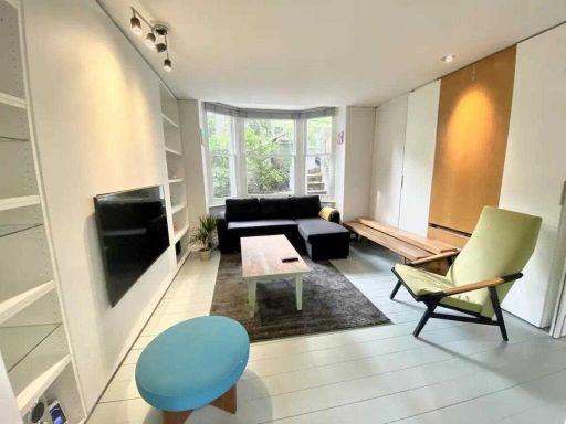 1 bedroom flat for sale in A, Southcote Road, London, N19 — £400,000 • 1 bed • 1 bath • 559 ft²
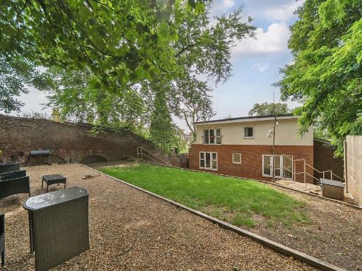 2 bedroom flat for sale in Archway Road, London, N19 — £350,000 • 2 bed • 1 bath • 714 ft²
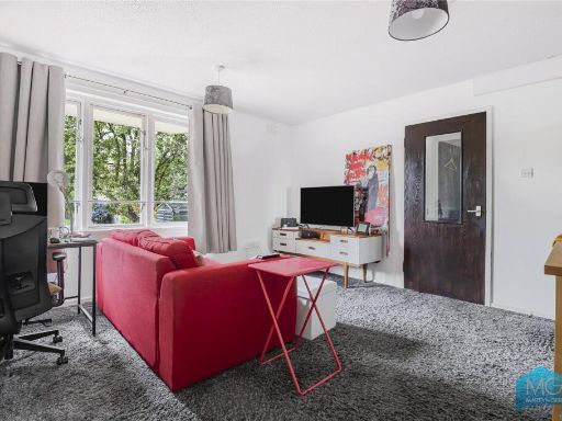 1 bedroom apartment for sale in Bredgar Road, Archway, N19 — £325,000 • 1 bed • 1 bath • 504 ft²
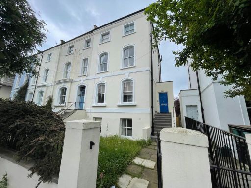 3 bedroom flat for sale in Miranda Road, London, N19 — £695,000 • 3 bed • 1 bath • 818 ft²
 1 bedroom flat for sale in Rowan Walk, Archway, London, N19 — £450,000 • 1 bed • 1 bath • 521 ft²
Meta
- {
"@context": "https://schema.org",
"@type": "Residence",
"name": "1 bedroom flat for sale in St. John's Way, London, N19",
"description": "",
"url": "https://propertypiper.co.uk/property/250e8df3-eb55-4ff7-8afe-0ca41ac88e0c",
"image": "https://image-a.propertypiper.co.uk/af74851d-42dd-4aab-8a2c-e29a8a0718ad-1024.jpeg",
"address": {
"@type": "PostalAddress",
"streetAddress": "FLAT A, 30, ST JOHN'S WAY",
"postalCode": "N19 3RR",
"addressLocality": "Islington",
"addressRegion": "Islington North",
"addressCountry": "England"
},
"geo": {
"@type": "GeoCoordinates",
"latitude": 51.566207542019846,
"longitude": -0.13328862478940737
},
"numberOfRooms": 1,
"numberOfBathroomsTotal": 1,
"floorSize": {
"@type": "QuantitativeValue",
"value": 581,
"unitCode": "FTK"
},
"offers": {
"@type": "Offer",
"price": 400000,
"priceCurrency": "GBP",
"availability": "https://schema.org/InStock"
},
"additionalProperty": [
{
"@type": "PropertyValue",
"name": "Feature",
"value": "Victorian"
},
{
"@type": "PropertyValue",
"name": "Feature",
"value": "terraced house"
},
{
"@type": "PropertyValue",
"name": "Feature",
"value": "brickwork"
},
{
"@type": "PropertyValue",
"name": "Feature",
"value": "period"
},
{
"@type": "PropertyValue",
"name": "Feature",
"value": "high ceilings"
},
{
"@type": "PropertyValue",
"name": "Feature",
"value": "garden"
},
{
"@type": "PropertyValue",
"name": "Feature",
"value": "garden"
},
{
"@type": "PropertyValue",
"name": "Feature",
"value": "outdoor space"
},
{
"@type": "PropertyValue",
"name": "Feature",
"value": "landscaped"
},
{
"@type": "PropertyValue",
"name": "Feature",
"value": "greenery"
},
{
"@type": "PropertyValue",
"name": "Feature",
"value": "privacy"
},
{
"@type": "PropertyValue",
"name": "Feature",
"value": "trees"
},
{
"@type": "PropertyValue",
"name": "Feature",
"value": "stone paving"
},
{
"@type": "PropertyValue",
"name": "Feature",
"value": "lawn"
}
]
}
High Res Floorplan Images
Compatible Floorplan Images
FloorplanImages Thumbnail