IP19 0LQ - Land for sale in Linstead, Near Halesworth, Suffolk, IP19
View on Property Piper
Land for sale in Linstead, Near Halesworth, Suffolk, IP19
Property Details
- Price: £350000
- Bedrooms: 1
- Bathrooms: 1
- Property Type: undefined
- Property SubType: undefined
Brochure Descriptions
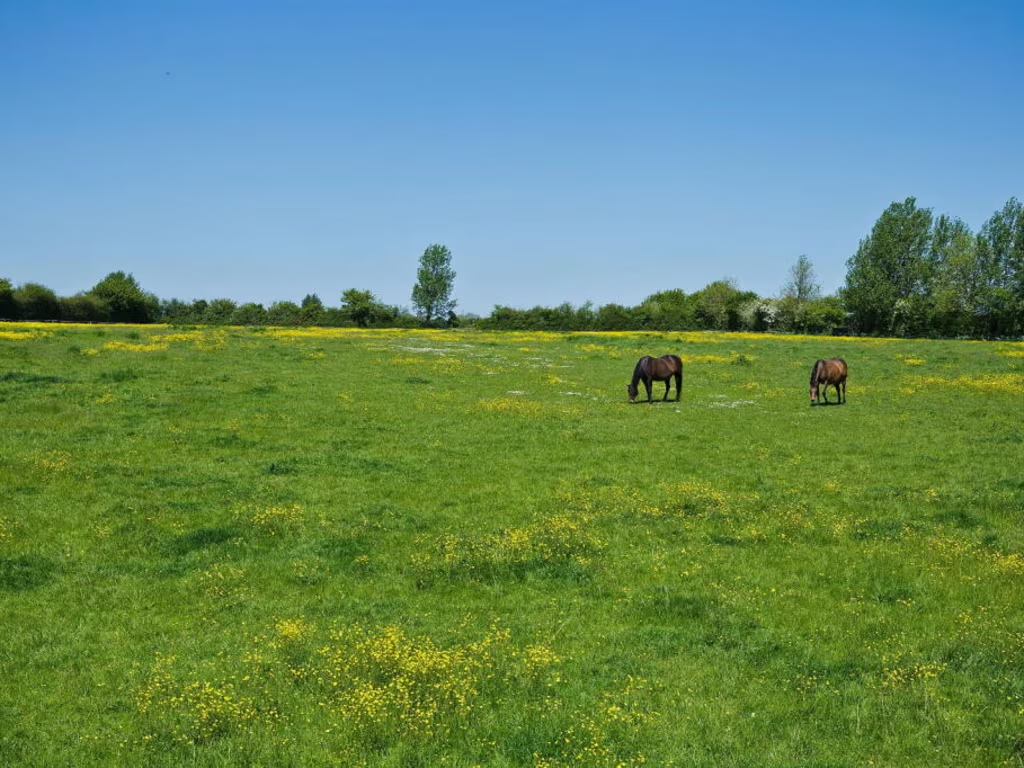
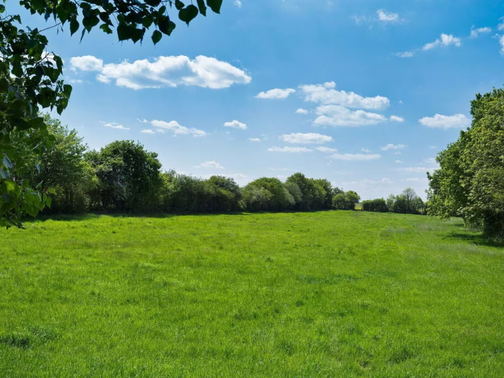
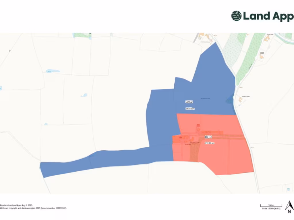
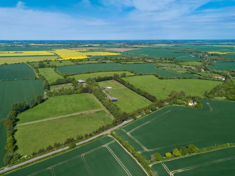
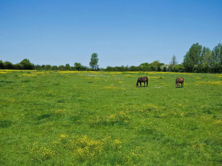
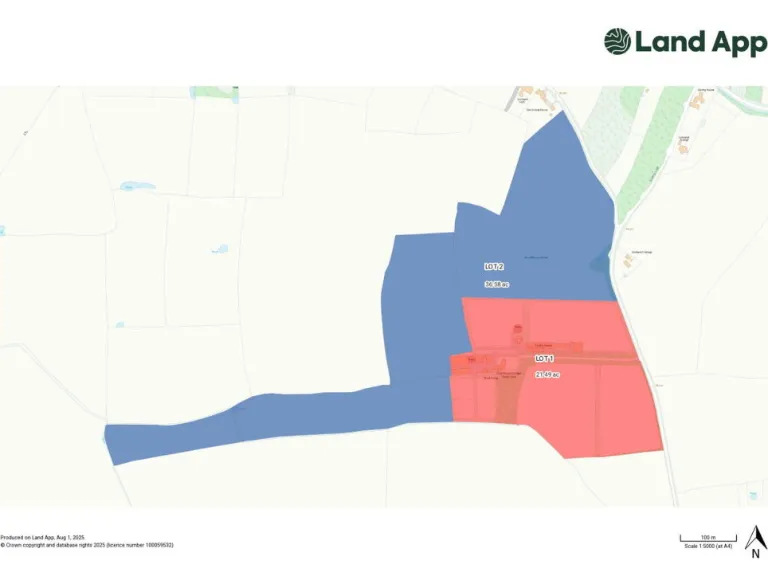
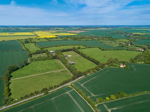
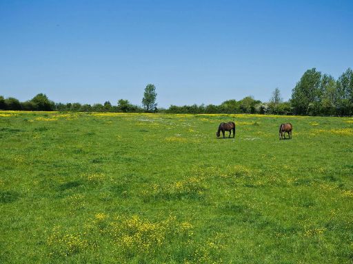
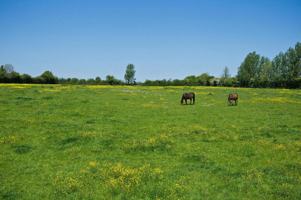
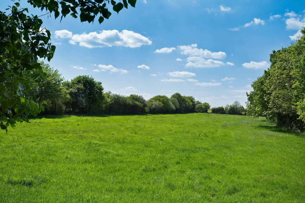
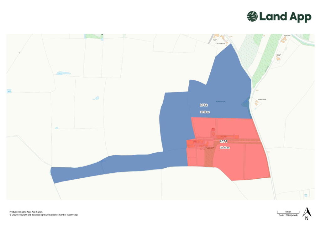
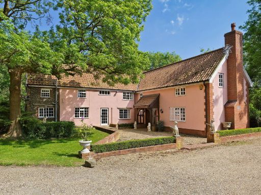
- Abbey Farm is a substantial small farm property comprising an attractive detached farmhouse with annex accommodation. The property includes a number of significant, historical and modern outbuildings, set amidst extensive paddocks and meadows. The grounds extend up to 58 acres overall, combining both pastures and grassland. The farmhouse is set in a large, mature garden with open views over adjoining countryside, ideal for equestrian or agricultural use. The overall scale is large, and the property offers substantial land and buildings, indicative of a significant rural estate.
Image Descriptions
- agricultural land
- open land or field rural
Textual Property Features
Detected Visual Features
- land
- agriculture
- development potential
- rural
- fields
- farming
- expansive
- green
- plots
- country
- pasture
- agricultural
- field
- horses
- nature
- estate
- grassland
Nearby Schools
- All Saints Church of England Primary School, Laxfield
- Holton St Peter Community Primary School
- Fressingfield Church of England Primary School
- Mendham Primary School
- Bramfield Church of England Primary School
- Edgar Sewter Community Primary School
- Ilketshall St Lawrence School
Nearest General Shops
- Id: 8109787655
- Tags:
- Name: Halesworth Toy Shop
- Shop: toys
- TagsNormalized:
- Lat: 52.3447804
- Lon: 1.5020618
- FullGeoHash: u131f1jf2w63
- PartitionGeoHash: u131
- Images:
- FoodStandards: null
- Distance: 5086.2
,- Id: 4227174292
- Tags:
- Addr:
- Housenumber: 56
- Postcode: IP19 8AR
- Street: Thoroughfare
- Village: Halesworth
- Name: Farmhouse Bakery
- Shop: bakery
- Url: http://www.breadfilledrolls-suffolk.co.uk/
- TagsNormalized:
- Lat: 52.3438792
- Lon: 1.5019519
- FullGeoHash: u131f0vtnn29
- PartitionGeoHash: u131
- Images:
- FoodStandards: null
- Distance: 5079.4
,- Id: 107201815
- Tags:
- Building: yes
- Name: Kerridges
- Shop: car
- Source: bing
- TagsNormalized:
- Lat: 52.3381338
- Lon: 1.4983906
- FullGeoHash: u131dpg5ep31
- PartitionGeoHash: u131
- Images:
- FoodStandards: null
- Distance: 4890.7
}
Nearest Religious buildings
- Id: 494914145
- Tags:
- Amenity: place_of_worship
- Building: church
- Denomination: anglican
- Name: St Michael
- Religion: christian
- Source:
- Wikidata: Q17527013
- Wikipedia: en:St Michael and All Angels' Church, Cookley
- TagsNormalized:
- place of worship
- church
- anglican
- christian
- Lat: 52.325883
- Lon: 1.4466081
- FullGeoHash: u1318vtkk7t4
- PartitionGeoHash: u131
- Images:
- FoodStandards: null
- Distance: 2466.7
,- Id: 190107501
- Tags:
- Amenity: place_of_worship
- Denomination: anglican
- Name: St Mary, Chediston
- Religion: christian
- Wikidata: Q17527008
- TagsNormalized:
- place of worship
- anglican
- christian
- church
- Lat: 52.3473938
- Lon: 1.4612295
- FullGeoHash: u131c3819j7x
- PartitionGeoHash: u131
- Images:
- FoodStandards: null
- Distance: 2332.7
,- Id: 151555294
- Tags:
- Amenity: place_of_worship
- Denomination: anglican
- Name: St Margaret of Antioch, Linstead Parva
- Religion: christian
- Wikidata: Q17527004
- TagsNormalized:
- place of worship
- anglican
- christian
- church
- Lat: 52.3477748
- Lon: 1.4302808
- FullGeoHash: u131b997zuqx
- PartitionGeoHash: u131
- Images:
- FoodStandards: null
- Distance: 408.3
}
Nearest Medical buildings
- Id: 1211901505
- Tags:
- Amenity: pharmacy
- Healthcare: pharmacy
- Name: Cutlers Hill Surgery Pharmacy
- TagsNormalized:
- pharmacy
- health
- healthcare
- surgery
- Lat: 52.3476261
- Lon: 1.5079084
- FullGeoHash: u131f3d50bcb
- PartitionGeoHash: u131
- Images:
- FoodStandards: null
- Distance: 5493.3
,- Id: 870579713
- Tags:
- Amenity: hospital
- Healthcare: hospital
- TagsNormalized:
- Lat: 52.3478365
- Lon: 1.5077096
- FullGeoHash: u131f39uk0jb
- PartitionGeoHash: u131
- Images:
- FoodStandards: null
- Distance: 5481.3
,- Id: 9457768869
- Tags:
- Amenity: dentist
- Healthcare: dentist
- Name: Daniel Evans & Associates
- TagsNormalized:
- Lat: 52.345305
- Lon: 1.5031272
- FullGeoHash: u131f1nt92hg
- PartitionGeoHash: u131
- Images:
- FoodStandards: null
- Distance: 5159.1
,- Id: 994750485
- Tags:
- Addr:
- City: Halesworth
- Housenumber: 26
- Postcode: IP19 8AY
- Street: Market Place
- Amenity: pharmacy
- Brand: Boots
- Brand:wikidata: Q6123139
- Brand:wikipedia: en:Boots UK
- Fhrs:
- Healthcare: pharmacy
- Name: Boots
- Source:
- TagsNormalized:
- pharmacy
- boots
- health
- healthcare
- Lat: 52.3430125
- Lon: 1.5015772
- FullGeoHash: u131f0v2jk9p
- PartitionGeoHash: u131
- Images:
- FoodStandards:
- Id: 1074403
- FHRSID: 1074403
- LocalAuthorityBusinessID: 06/01466/CP
- BusinessName: Boots UK Ltd
- BusinessType: Retailers - other
- BusinessTypeID: 4613
- AddressLine1: 26 Market Place
- AddressLine2: Halesworth
- AddressLine3: Suffolk
- AddressLine4: null
- PostCode: IP19 8AY
- RatingValue: Exempt
- RatingKey: fhrs_exempt_en-GB
- RatingDate: 2012-05-29
- LocalAuthorityCode: 302
- LocalAuthorityName: East Suffolk
- LocalAuthorityWebSite: http://www.eastsuffolk.gov.uk
- LocalAuthorityEmailAddress: environment@eastsuffolk.gov.uk
- Scores:
- Hygiene: null
- Structural: null
- ConfidenceInManagement: null
- NewRatingPending: false
- Geocode:
- Longitude: 1.50132800000000
- Latitude: 52.34301500000000
- Distance: 5056.5
}
Nearest Leisure Facilities
- Id: 415610950
- Tags:
- Barrier: hedge
- Landuse: meadow
- Leisure: nature_reserve
- Name: Winks Meadow
- Operator: Suffolk Wildlife Trust
- Wikidata: Q8025496
- TagsNormalized:
- meadow
- nature reserve
- leisure
- Lat: 52.3682209
- Lon: 1.3822204
- FullGeoHash: u12czmqdbpfj
- PartitionGeoHash: u12c
- Images:
- FoodStandards: null
- Distance: 4026.1
,- Id: 913272086
- Tags:
- TagsNormalized:
- Lat: 52.3752602
- Lon: 1.4497961
- FullGeoHash: u131byxsn8nk
- PartitionGeoHash: u131
- Images:
- FoodStandards: null
- Distance: 3736.3
,- Id: 322854490
- Tags:
- Designation: millennium_green
- Leisure: park
- Name: Huntingfield (Millennium Green)
- Note: V1 as per the Natural England dataset.
- Source: Natural England
- TagsNormalized:
- Lat: 52.311954
- Lon: 1.4342662
- FullGeoHash: u1318eh7hz42
- PartitionGeoHash: u131
- Images:
- FoodStandards: null
- Distance: 3664.7
,- Id: 974135601
- Tags:
- TagsNormalized:
- Lat: 52.3248929
- Lon: 1.3948553
- FullGeoHash: u12cxtrww7p2
- PartitionGeoHash: u12c
- Images:
- FoodStandards: null
- Distance: 3105
,- Id: 9071657271
- Tags:
- TagsNormalized:
- miniature golf
- golf
- leisure
- Lat: 52.352405
- Lon: 1.3880157
- FullGeoHash: u12czd6wz5es
- PartitionGeoHash: u12c
- Images:
- FoodStandards: null
- Distance: 2797.8
}
Nearest Tourist attractions
- Id: 994395743
- Tags:
- Name: Halesworth Museum
- Tourism: museum
- Website: https://halesworthmuseum.org.uk/
- Wikidata: Q113310214
- TagsNormalized:
- Lat: 52.346892
- Lon: 1.5057064
- FullGeoHash: u131f32qtxbj
- PartitionGeoHash: u131
- Images:
- FoodStandards: null
- Distance: 5339.6
,- Id: 471496349
- Tags:
- Addr:
- City: Metfield
- Postcode: IP20 0LB
- Street: The Street
- Guest_house: bed_and_breakfast
- Name: Duke William B&B
- Phone: +44 1379 586 371
- Tourism: guest_house
- Website: http://www.dukewilliammetfield.co.uk
- TagsNormalized:
- Lat: 52.3716634
- Lon: 1.370249
- FullGeoHash: u12czjvz11et
- PartitionGeoHash: u12c
- Images:
- FoodStandards: null
- Distance: 4897.9
,- Id: 980706066
- Tags:
- Addr:
- City: Linstead
- Housename: The Camel Park Oasis
- Postcode: IP19 0DT
- Street: Orchard Farm
- Email: info@oasiscamelpark.co.uk
- Name: Oasis Camel Park
- Phone: +44 7836 734748
- Tourism: zoo
- Website: https://www.oasiscamelpark.co.uk
- TagsNormalized:
- Lat: 52.352636
- Lon: 1.3870461
- FullGeoHash: u12czdd00w8w
- PartitionGeoHash: u12c
- Images:
- FoodStandards: null
- Distance: 2868.4
}
Nearest Train stations
- Id: 252746160
- Tags:
- Name: Beccles
- Naptan:
- Network: National Rail
- Public_transport: station
- Railway: station
- Ref:
- Source: NPE
- Wikidata: Q2659206
- Wikipedia: en:Beccles railway station
- TagsNormalized:
- Lat: 52.4588262
- Lon: 1.5696314
- FullGeoHash: u1347tyfz1fp
- PartitionGeoHash: u134
- Images:
- FoodStandards: null
- Distance: 15957.4
,- Id: 310588000
- Tags:
- Name: Saxmundham
- Naptan:
- Network: National Rail
- Public_transport: station
- Railway: station
- Ref:
- Wheelchair: yes
- Wikidata: Q763638
- Wikipedia: en:Saxmundham railway station
- TagsNormalized:
- Lat: 52.2152245
- Lon: 1.4902723
- FullGeoHash: u1311cmptz7d
- PartitionGeoHash: u131
- Images:
- FoodStandards: null
- Distance: 15015.2
,- Id: 252754155
- Tags:
- Name: Darsham
- Naptan:
- Network: National Rail
- Public_transport: station
- Railway: station
- Ref:
- Source: Bing
- Train: yes
- Wikidata: Q2998721
- Wikipedia: en:Darsham railway station
- TagsNormalized:
- Lat: 52.2730379
- Lon: 1.5235658
- FullGeoHash: u1316sj2t8t1
- PartitionGeoHash: u131
- Images:
- FoodStandards: null
- Distance: 10310.1
,- Id: 256709377
- Tags:
- Name: Brampton
- Naptan:
- Network: National Rail
- Public_transport: station
- Railway: station
- Ref:
- Request_stop: yes
- Wikidata: Q2599812
- Wikipedia: en:Brampton railway station (Suffolk)
- TagsNormalized:
- Lat: 52.3955079
- Lon: 1.5438215
- FullGeoHash: u13454k1vwse
- PartitionGeoHash: u134
- Images:
- FoodStandards: null
- Distance: 9732
,- Id: 1080701323
- Tags:
- Name: Halesworth
- Naptan:
- Network: National Rail
- Public_transport: station
- Railway: station
- Ref:
- Wikidata: Q2406246
- Wikipedia: en:Halesworth railway station
- TagsNormalized:
- Lat: 52.3469592
- Lon: 1.5057452
- FullGeoHash: u131f32rnkky
- PartitionGeoHash: u131
- Images:
- FoodStandards: null
- Distance: 5342.6
}
Nearest Hotels
- Id: 131644029
- Tags:
- Amenity: parking
- Capacity: 118
- Name: Angel Hotel Carpark
- Source: bing
- TagsNormalized:
- Lat: 52.342955
- Lon: 1.5037563
- FullGeoHash: u131f0xpb41b
- PartitionGeoHash: u131
- Images:
- FoodStandards: null
- Distance: 5204.7
,- Id: 131644030
- Tags:
- Amenity: parking
- Capacity: 118
- Name: Angel Hotel Carpark
- Source: bing
- TagsNormalized:
- Lat: 52.3428388
- Lon: 1.5031427
- FullGeoHash: u131f0wx1u27
- PartitionGeoHash: u131
- Images:
- FoodStandards: null
- Distance: 5163.5
,- Id: 994750472
- Tags:
- Amenity: pub
- Name: The Angel Hotel
- Wikidata: Q26557508
- TagsNormalized:
- Lat: 52.3431436
- Lon: 1.5026769
- FullGeoHash: u131f0y0yvjj
- PartitionGeoHash: u131
- Images:
- FoodStandards: null
- Distance: 5130.7
}
Tags
- land
- agriculture
- development potential
- rural
- fields
- farming
- expansive
- green
- plots
- country
- pasture
- agricultural
- land
- field
- rural
- horses
- nature
- estate
- grassland
Local Market Stats
- Average Price/sqft: £318
- Avg Income: £39500
- Social Housing: 8%
- Planning Success Rate: 91%
Similar Properties
 5 bedroom detached house for sale in Linstead, Near Halesworth, Suffolk, IP19 — £1,100,000 • 5 bed • 3 bath • 2813 ft²
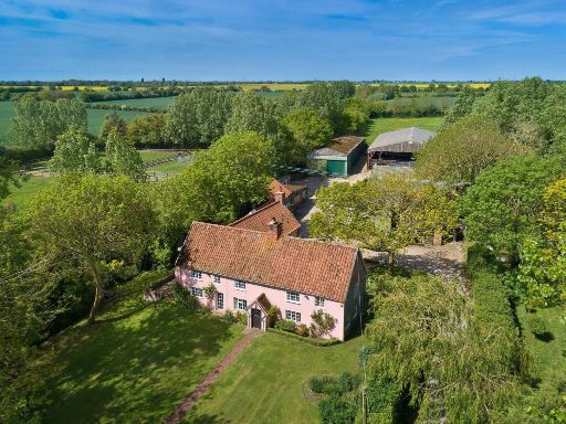 5 bedroom detached house for sale in Linstead, Near Halesworth, Suffolk, IP19 — £1,450,000 • 5 bed • 3 bath • 2813 ft²
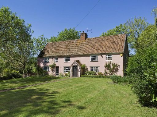 5 bedroom detached house for sale in Linstead, Halesworth, Suffolk, IP19 — £950,000 • 5 bed • 3 bath • 2813 ft²
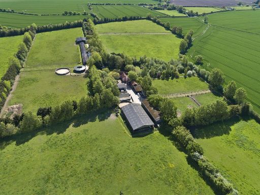 Equestrian facility for sale in Linstead, Halesworth, Suffolk, IP19 — £1,450,000 • 5 bed • 3 bath • 2813 ft²
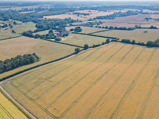 Equestrian facility for sale in Cookley, Halesworth, Suffolk, IP19 — £400,000 • 1 bed • 1 bath • 2999 ft²
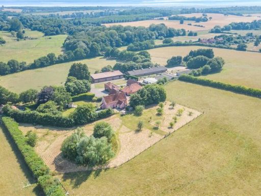 Detached house for sale in Cookley, Halesworth, Suffolk, IP19 — £2,100,000 • 1 bed • 1 bath • 2999 ft²
Meta
- {
"@context": "https://schema.org",
"@type": "Residence",
"name": "Land for sale in Linstead, Near Halesworth, Suffolk, IP19",
"description": "",
"url": "https://propertypiper.co.uk/property/2246fef3-80f8-492b-bc3d-5f8ade74bb17",
"image": "https://image-a.propertypiper.co.uk/8af7376a-ddc2-46a4-b2b6-a8a418782834-1024.jpeg",
"address": {
"@type": "PostalAddress",
"streetAddress": "Linstead, Near Halesworth, Suffolk",
"postalCode": "IP19 0LQ",
"addressLocality": "East Suffolk",
"addressRegion": "Suffolk Coastal",
"addressCountry": "England"
},
"geo": {
"@type": "GeoCoordinates",
"latitude": 52.3446262,
"longitude": 1.4271882
},
"numberOfRooms": 1,
"numberOfBathroomsTotal": 1,
"offers": {
"@type": "Offer",
"price": 350000,
"priceCurrency": "GBP",
"availability": "https://schema.org/InStock"
},
"additionalProperty": [
{
"@type": "PropertyValue",
"name": "Feature",
"value": "land"
},
{
"@type": "PropertyValue",
"name": "Feature",
"value": "agriculture"
},
{
"@type": "PropertyValue",
"name": "Feature",
"value": "development potential"
},
{
"@type": "PropertyValue",
"name": "Feature",
"value": "rural"
},
{
"@type": "PropertyValue",
"name": "Feature",
"value": "fields"
},
{
"@type": "PropertyValue",
"name": "Feature",
"value": "farming"
},
{
"@type": "PropertyValue",
"name": "Feature",
"value": "expansive"
},
{
"@type": "PropertyValue",
"name": "Feature",
"value": "green"
},
{
"@type": "PropertyValue",
"name": "Feature",
"value": "plots"
},
{
"@type": "PropertyValue",
"name": "Feature",
"value": "country"
},
{
"@type": "PropertyValue",
"name": "Feature",
"value": "pasture"
},
{
"@type": "PropertyValue",
"name": "Feature",
"value": "agricultural"
},
{
"@type": "PropertyValue",
"name": "Feature",
"value": "land"
},
{
"@type": "PropertyValue",
"name": "Feature",
"value": "field"
},
{
"@type": "PropertyValue",
"name": "Feature",
"value": "rural"
},
{
"@type": "PropertyValue",
"name": "Feature",
"value": "horses"
},
{
"@type": "PropertyValue",
"name": "Feature",
"value": "nature"
},
{
"@type": "PropertyValue",
"name": "Feature",
"value": "estate"
},
{
"@type": "PropertyValue",
"name": "Feature",
"value": "grassland"
}
]
}