CA23 3EX - 3 bedroom bungalow for sale in Black How Farm, (Dawn View),…
View on Property Piper
3 bedroom bungalow for sale in Black How Farm, (Dawn View), Cleator CA23 3EX, CA23
Property Details
- Price: £695000
- Bedrooms: 3
- Bathrooms: 2
- Property Type: undefined
- Property SubType: undefined
Brochure Descriptions
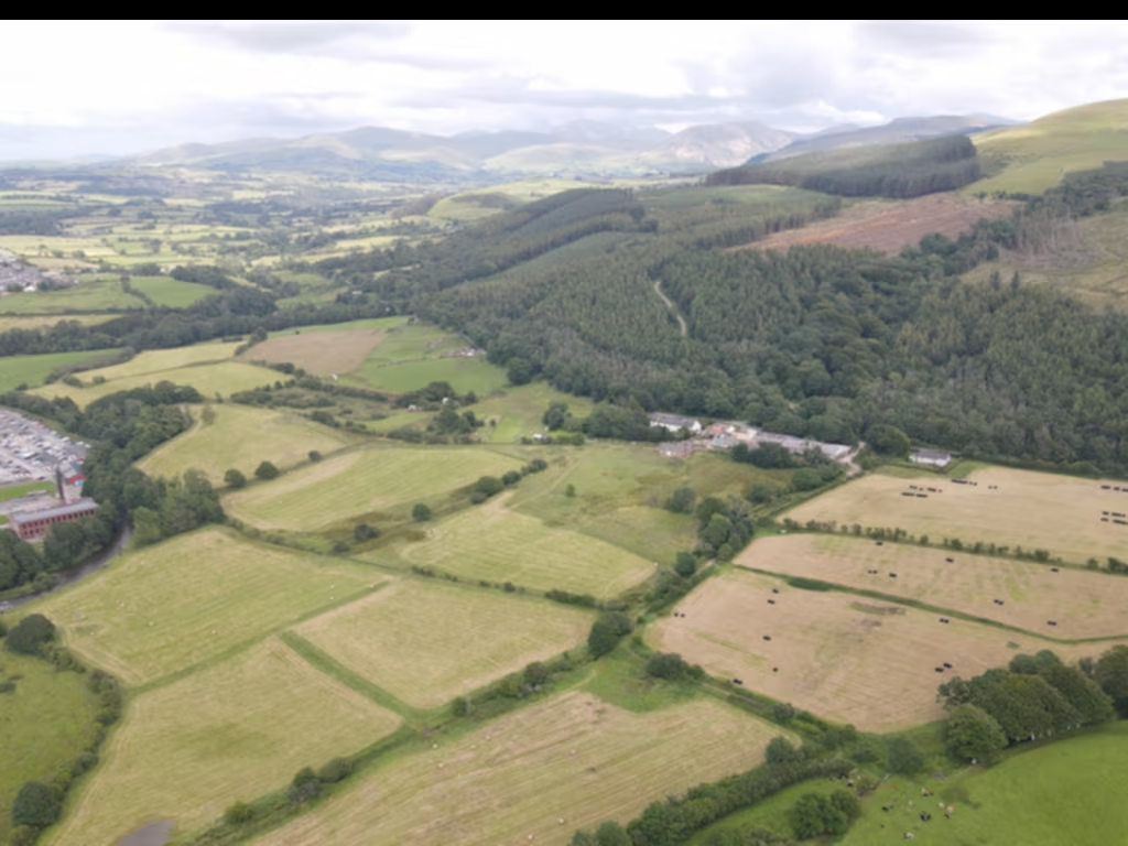
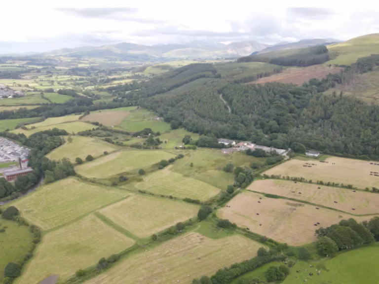
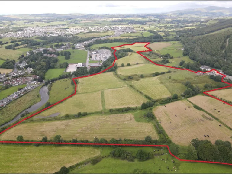
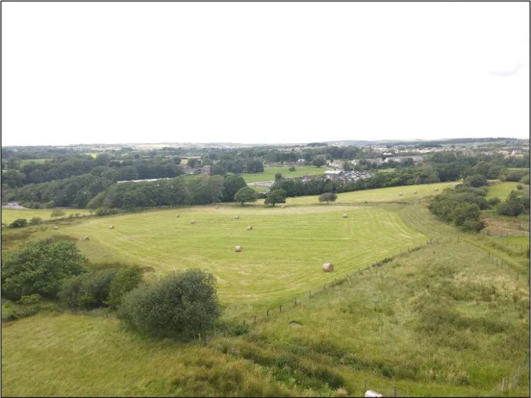
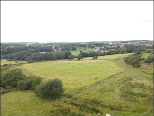
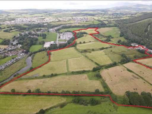
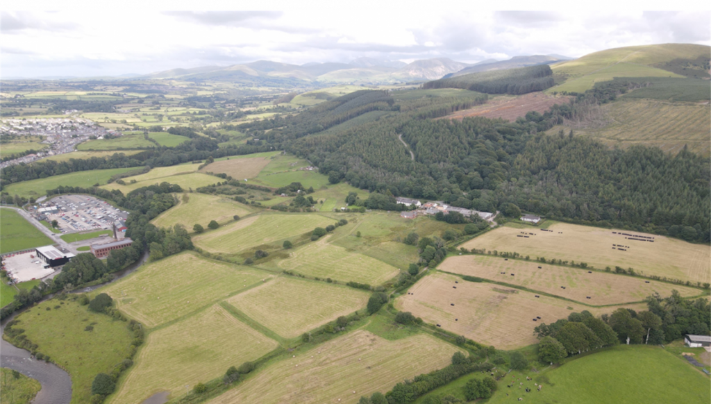
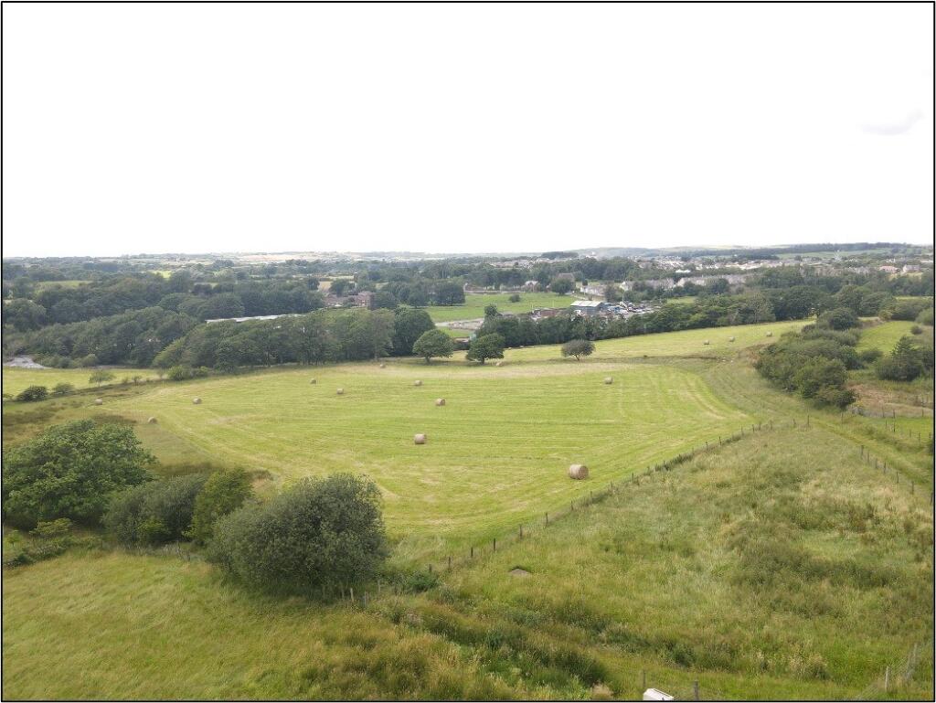
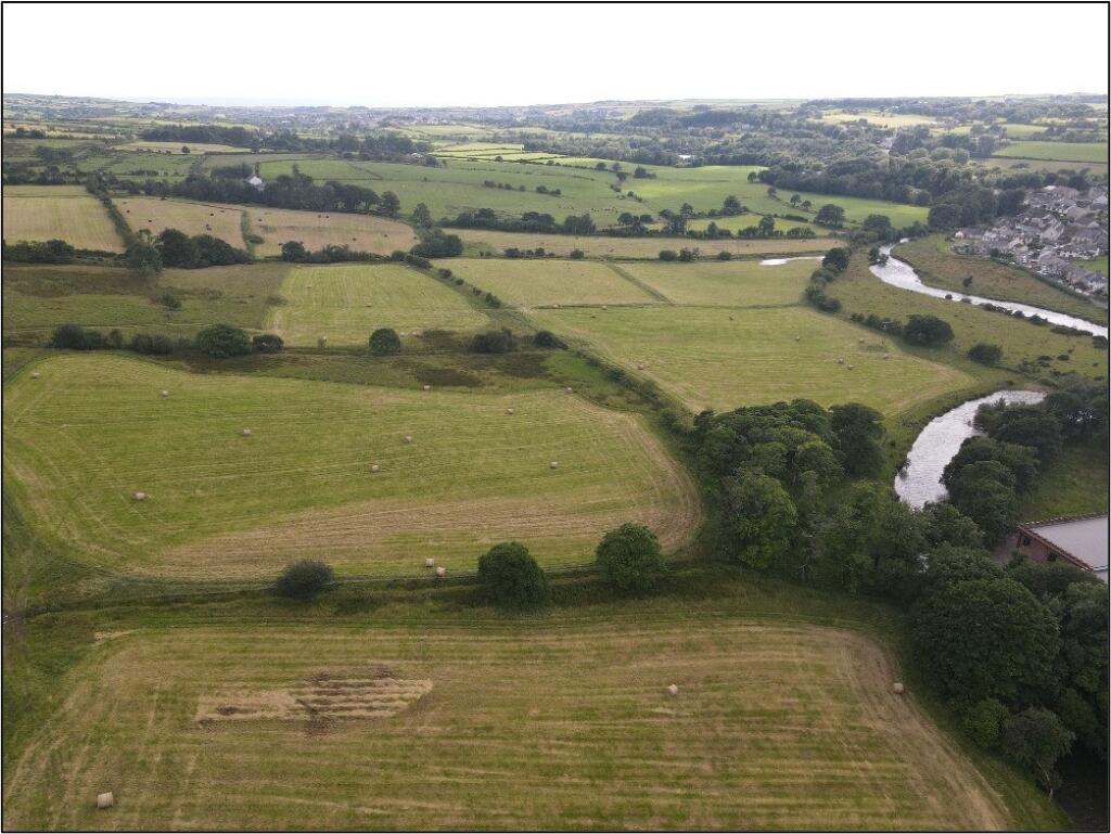
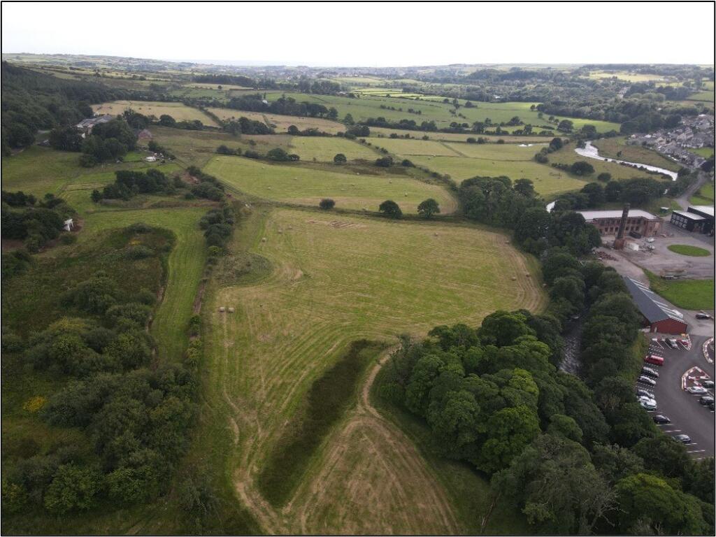
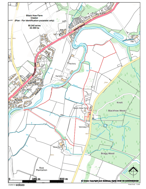
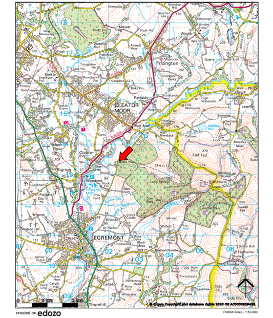
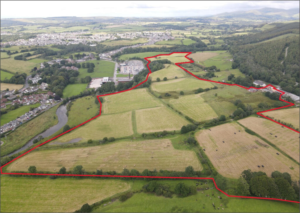
- The property for sale is an agricultural farm estate situated in a scenic rural setting, surrounded by expansive fields and rolling hills. The estate covers a very large area, comprising multiple fields suitable for grazing or cultivation, with well-defined boundaries and some wooded areas in the background. No residential buildings are clearly visible, but the property clearly includes vast open land, ideal for agricultural or equestrian use. The views are exceptional, overlooking countryside, woodland, and distant hills, ensuring privacy and tranquility. The overall size of the property is very large, indicative of a substantial farm holding.
Image Descriptions
- rural farmland
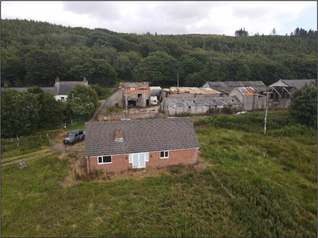
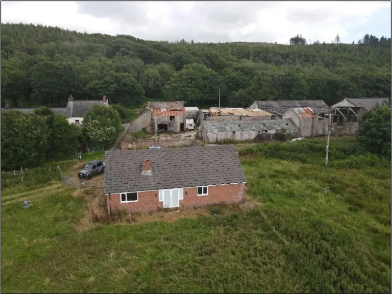
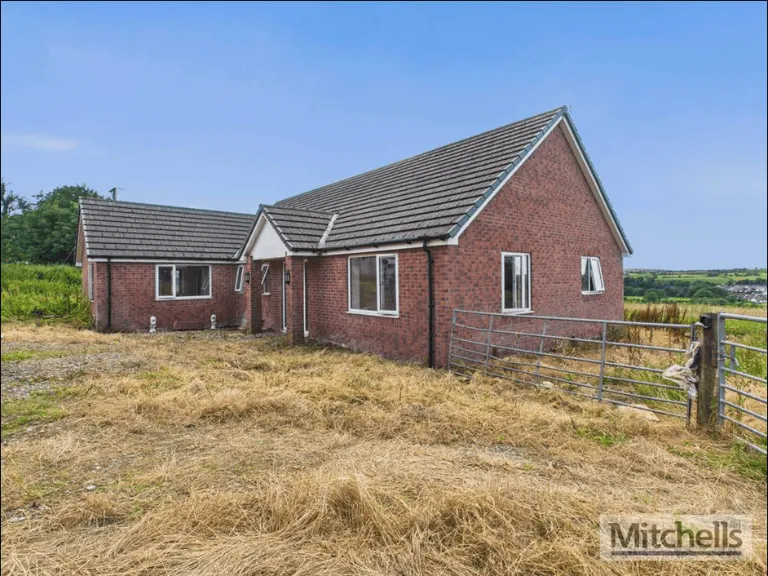
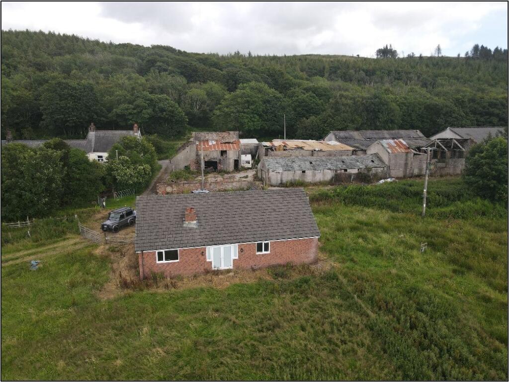
- single-storey bungalow modern
Floorplan Description
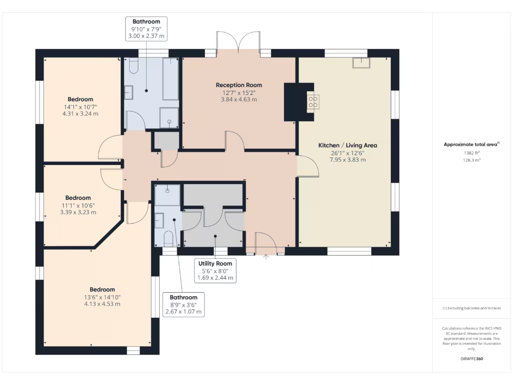
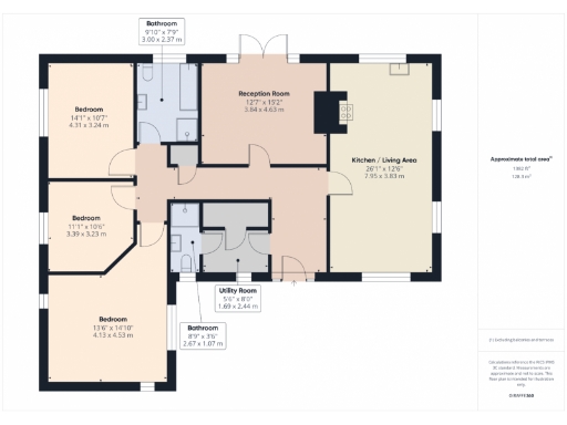
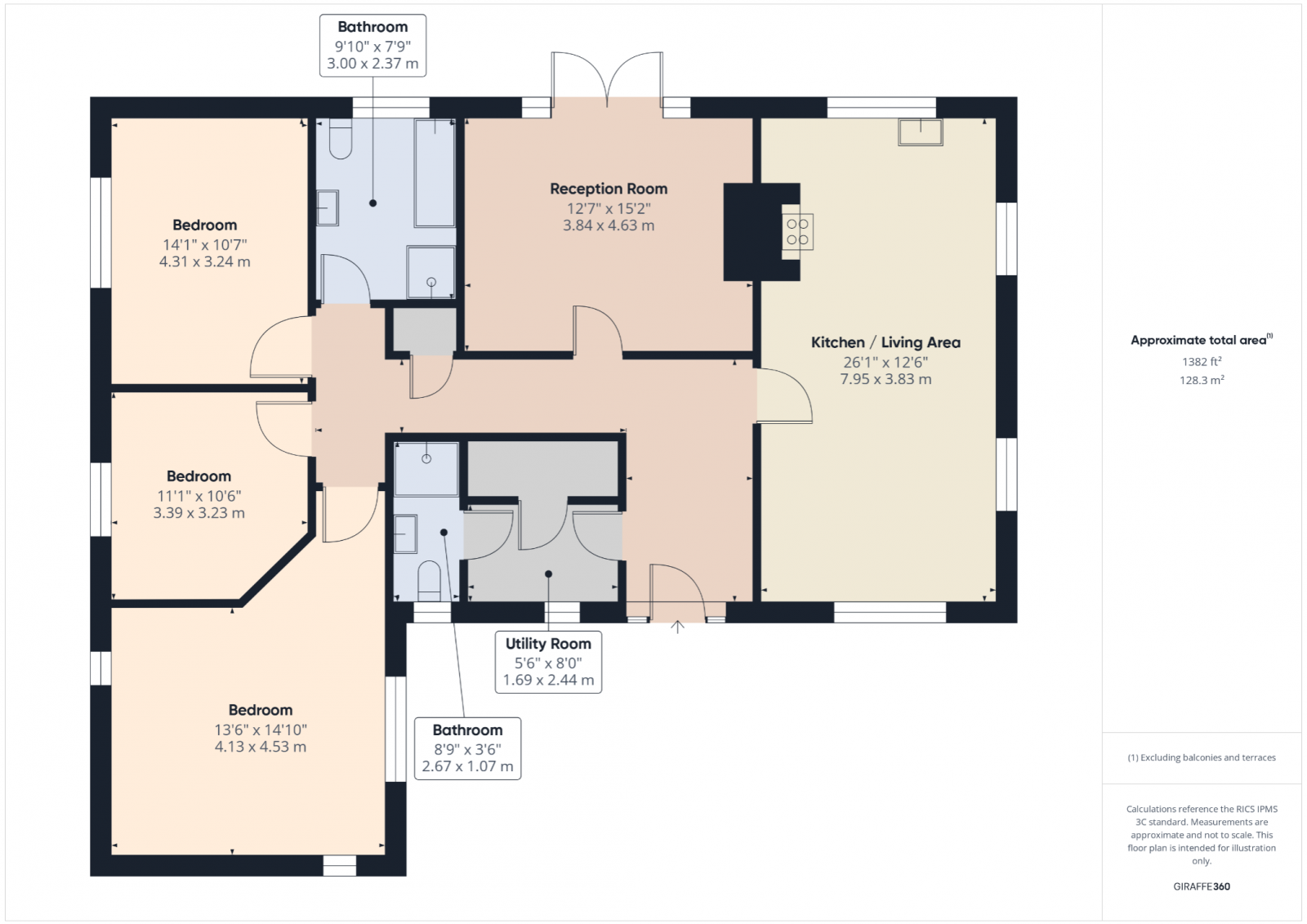
- A spacious property with three bedrooms, a large kitchen/living area, and two bathrooms.
Rooms
- Bedroom: Large
- Bedroom: Average
- Bedroom: Large
- Bathroom: Average
- Bathroom: Small
- Reception Room: Large
- Kitchen / Living Area: Large
- Utility Room: Small
Textual Property Features
- Is Auction
- Probate Detected
- Success
Detected Visual Features
- rural
- farmland
- countryside
- fields
- agricultural
- pasture
- trees
- scenic
- rolling hills
- open space
- land
- bungalow
- single-storey
- modern
- brick exterior
- pitch roof
- rural location
- fixer-upper
- neglected
EPC Details
- Fully double glazed
- Sandstone or limestone, as built, no insulation (assumed)
- Boiler and radiators, oil
- Low energy lighting in 8% of fixed outlets
- Solid, no insulation (assumed)
Nearby Schools
- Beckermet CofE School
- Thornhill Primary School
- St Bridget's Catholic Primary School
- St Bees School
- St Patrick's Catholic Primary School
- The Whitehaven Academy
- Kirkland Church of England Academy
- Bransty Primary School
- Valley Primary School and Nursery
- Kells Infant School
- Monkwray Junior School
- St Joseph's Catholic Primary School
- St James' CofE Infant and Nursery School
- St James' CofE Junior School
- Bookwell Primary School
- Orgill Primary School
- West Lakes Academy
- Hensingham Primary School
- Jericho Primary School
- Frizington Community Primary School
- Arlecdon Primary School
- St Bees Village Primary School
- Moor Row Community Primary School
- Montreal CofE Primary School
- Ennerdale and Kinniside CofE Primary School
- St Gregory and St Patrick's Catholic Infant School
- St Begh's Catholic Junior School
- St Benedict's Catholic High School
- Moresby Primary School
Nearest Bars And Restaurants
- Id: 331374906
- Tags:
- Addr:
- City: Cleator Moor
- Postcode: CA25 5LG
- Street: Ennerdale Road
- Amenity: pub
- Building: yes
- Name: Derby Arms
- Phone: +44 1946 815560
- TagsNormalized:
- Lat: 54.5202085
- Lon: -3.5127875
- FullGeoHash: gctw0j454p7z
- PartitionGeoHash: gctw
- Images:
- FoodStandards: null
- Distance: 1692.7
,- Id: 331374909
- Tags:
- Addr:
- City: Cleator Moor
- Postcode: CA25 5LD
- Street: Ennerdale Road
- Amenity: fast_food
- Building: yes
- Name: Sproaty's Chippy
- Phone: +44 1946 813786
- TagsNormalized:
- Lat: 54.5188192
- Lon: -3.5097604
- FullGeoHash: gctw0hu70ssb
- PartitionGeoHash: gctw
- Images:
- FoodStandards: null
- Distance: 1536
,- Id: 331385054
- Tags:
- Addr:
- City: Cleator Moor
- Housenumber: 85
- Postcode: CA23 3EH
- Street: Trumpet Road
- Amenity: pub
- Building: yes
- Name: Little Arms
- Phone: +44 1946 813988
- TagsNormalized:
- Lat: 54.5166685
- Lon: -3.5038255
- FullGeoHash: gctw0k2wdgw6
- PartitionGeoHash: gctw
- Images:
- FoodStandards: null
- Distance: 1374.2
,- Id: 340953303
- Tags:
- Addr:
- City: Cleator
- Housenumber: 93
- Postcode: CA23 3DX
- Street: Trumpet Terrace
- Amenity: pub
- Amenity_1: restaurant
- Building: yes
- Cuisine: international
- Name: The Brook Inn
- Opening_hours: Mo-Su 09:00-17:00
- Phone: +44 1946 811635
- Smoking: outside
- Source: http://www.thebrookinncleator.co.uk/
- Website: http://www.thebrookinncleator.co.uk/
- TagsNormalized:
- Lat: 54.5124141
- Lon: -3.5140122
- FullGeoHash: gctw059jvdd8
- PartitionGeoHash: gctw
- Images:
- FoodStandards: null
- Distance: 845.2
,- Id: 3481706449
- Tags:
- Amenity: pub
- Name: Three Tuns
- TagsNormalized:
- Lat: 54.506812
- Lon: -3.5224682
- FullGeoHash: gctqpfej0w1q
- PartitionGeoHash: gctq
- Images:
- FoodStandards: null
- Distance: 769.5
}
Nearest General Shops
- Id: 3693245403
- Tags:
- Addr:
- City: Cleator Moor
- Housenumber: 2
- Postcode: CA25 5AR
- Street: Market Street
- Name: The Candy Shop
- Phone: +44 1946 813821
- Shop: hairdresser
- TagsNormalized:
- Lat: 54.5209998
- Lon: -3.5155244
- FullGeoHash: gctw0j0pf750
- PartitionGeoHash: gctw
- Images:
- FoodStandards: null
- Distance: 1800.8
,- Id: 331385055
- Tags:
- Addr:
- City: Cleator Moor
- Housenumber: 1
- Postcode: CA25 5LD
- Street: Ennerdale Road
- Building: yes
- Name: Kirkland Carpets
- Shop: carpet
- TagsNormalized:
- Lat: 54.5210814
- Lon: -3.5136185
- FullGeoHash: gctw0j32qf0n
- PartitionGeoHash: gctw
- Images:
- FoodStandards: null
- Distance: 1793.8
,- Id: 8866730517
- Tags:
- Name: Whitehouse Boarding Kennels
- Shop: pet
- TagsNormalized:
- Lat: 54.5142277
- Lon: -3.4909284
- FullGeoHash: gctw0s1brkx4
- PartitionGeoHash: gctw
- Images:
- FoodStandards: null
- Distance: 1648.9
}
Nearest Grocery shops
- Id: 331374910
- Tags:
- Building: yes
- Name: Lifestyle
- Shop: convenience
- TagsNormalized:
- Lat: 54.5187472
- Lon: -3.5096735
- FullGeoHash: gctw0hu6dxjf
- PartitionGeoHash: gctw
- Images:
- FoodStandards: null
- Distance: 1528.3
,- Id: 331374914
- Tags:
- Addr:
- City: Cleator Moor
- Postcode: CA25 5LP
- Street: Ennerdale Road
- Building: yes
- Name: Premier - Paul's
- Phone: +44 1946 810 446
- Shop: convenience
- TagsNormalized:
- Lat: 54.5177511
- Lon: -3.5065805
- FullGeoHash: gctw0hwsfv2h
- PartitionGeoHash: gctw
- Images:
- FoodStandards: null
- Distance: 1443.2
,- Id: 3384440208
- Tags:
- Amenity: fast_food
- Cuisine: fish_and_chips
- Name: Wath Brow Fish & Chip Shop
- TagsNormalized:
- fast food
- food
- fish
- chip
- shop
- Lat: 54.5170886
- Lon: -3.5049549
- FullGeoHash: gctw0hxc09uh
- PartitionGeoHash: gctw
- Images:
- FoodStandards: null
- Distance: 1396.4
}
Nearest Supermarkets
- Id: 294800606
- Tags:
- Addr:
- Postcode: CA28 9DL
- Street: Preston Street
- Alt_name: ALDI Whitehaven
- Brand: ALDI
- Brand:wikidata: Q41171672
- Brand:wikipedia: en:Aldi
- Building: yes
- Contact:
- Website: https://stores.aldi.co.uk/whitehaven/preston-street
- Name: ALDI
- Shop: supermarket
- TagsNormalized:
- Lat: 54.5444379
- Lon: -3.5900736
- FullGeoHash: gctqq39b3hpj
- PartitionGeoHash: gctq
- Images:
- FoodStandards: null
- Distance: 6728.8
,- Id: 294800597
- Tags:
- Addr:
- City: Whitehaven
- Country: GB
- Postcode: CA28 9DL
- Street: Preston Street
- Alt_name: ASDA Whitehaven Supermarket
- Brand: Asda
- Brand:wikidata: Q297410
- Brand:wikipedia: en:Asda
- Building: yes
- Contact:
- Website: https://storelocator.asda.com/north-west/whitehaven/preston-street
- Fhrs:
- Name: Asda
- Old_name: Netto
- Operator: Asda Stores Ltd
- Shop: supermarket
- TagsNormalized:
- Lat: 54.5427481
- Lon: -3.5904279
- FullGeoHash: gctqq31w8cnv
- PartitionGeoHash: gctq
- Images:
- FoodStandards:
- Id: 230267
- FHRSID: 230267
- LocalAuthorityBusinessID: PI/000004649
- BusinessName: Asda
- BusinessType: Retailers - supermarkets/hypermarkets
- BusinessTypeID: 7840
- AddressLine1: Preston Street
- AddressLine2: Whitehaven
- AddressLine3: Cumbria
- AddressLine4: null
- PostCode: CA28 9DL
- RatingValue: 5
- RatingKey: fhrs_5_en-GB
- RatingDate: 2020-01-06
- LocalAuthorityCode: 058
- LocalAuthorityName: Copeland
- LocalAuthorityWebSite: http://www.copeland.gov.uk
- LocalAuthorityEmailAddress: envhealth@copeland.gov.uk
- Scores:
- Hygiene: 5
- Structural: 5
- ConfidenceInManagement: 0
- NewRatingPending: false
- Geocode:
- Longitude: -3.59072600000000
- Latitude: 54.54357800000000
- Distance: 6625.7
,- Id: 312148840
- Tags:
- Addr:
- City: Whitehaven
- Postcode: CA28 7RW
- Street: Flatt Walks
- Alt_name: Morrisons Whitehaven
- Brand: Morrisons
- Brand:wikidata: Q922344
- Brand:wikipedia: en:Morrisons
- Building: yes
- Contact:
- Website: https://my.morrisons.com/storefinder/221
- Name: Morrisons
- Shop: supermarket
- TagsNormalized:
- Lat: 54.5459383
- Lon: -3.5850034
- FullGeoHash: gctqq3v3p7gs
- PartitionGeoHash: gctq
- Images:
- FoodStandards: null
- Distance: 6597.8
}
Nearest Religious buildings
- Id: 331385053
- Tags:
- Amenity: place_of_worship
- Building: yes
- Religion: christian
- TagsNormalized:
- place of worship
- christian
- church
- Lat: 54.5169601
- Lon: -3.5032807
- FullGeoHash: gctw0k8br9uw
- PartitionGeoHash: gctw
- Images:
- FoodStandards: null
- Distance: 1416.8
,- Id: 317672318
- Tags:
- Amenity: place_of_worship
- Building: yes
- Name: St Mary's Catholic Church
- Religion: christian
- Wikidata: Q26672115
- TagsNormalized:
- place of worship
- catholic
- church
- christian
- Lat: 54.5126796
- Lon: -3.5145506
- FullGeoHash: gctw058z3h10
- PartitionGeoHash: gctw
- Images:
- FoodStandards: null
- Distance: 882.4
,- Id: 340953305
- Tags:
- Amenity: place_of_worship
- Building: yes
- Denomination: anglican
- Name: St Leonard
- Religion: christian
- Wikidata: Q26620563
- TagsNormalized:
- place of worship
- anglican
- christian
- church
- Lat: 54.5068518
- Lon: -3.5239543
- FullGeoHash: gctqpf9vmvt5
- PartitionGeoHash: gctq
- Images:
- FoodStandards: null
- Distance: 863.5
}
Nearest Medical buildings
- Id: 321492736
- Tags:
- Amenity: pharmacy
- Brand:
- Dispensing: yes
- Name: Boots
- TagsNormalized:
- Lat: 54.4832629
- Lon: -3.5285096
- FullGeoHash: gctmzwqs5b2d
- PartitionGeoHash: gctm
- Images:
- FoodStandards: null
- Distance: 2672.1
,- Id: 262558495
- Tags:
- Amenity: parking
- Name: Healthcare Centre Parking
- Parking: surface
- TagsNormalized:
- Lat: 54.5229106
- Lon: -3.5167169
- FullGeoHash: gctqpvx4yx1y
- PartitionGeoHash: gctq
- Images:
- FoodStandards: null
- Distance: 2023.5
,- Id: 5088265244
- Tags:
- TagsNormalized:
- Lat: 54.522786
- Lon: -3.5160192
- FullGeoHash: gctqpvxdnzfp
- PartitionGeoHash: gctq
- Images:
- FoodStandards: null
- Distance: 2002
,- Id: 262558494
- Tags:
- Amenity: doctors
- Building: yes
- Emergency: no
- Healthcare: doctor
- Name: Healthcare Centre
- TagsNormalized:
- doctor
- doctors
- health
- healthcare
- Lat: 54.5227586
- Lon: -3.5162356
- FullGeoHash: gctqpvxd1fbe
- PartitionGeoHash: gctq
- Images:
- FoodStandards: null
- Distance: 2001.3
}
Nearest Leisure Facilities
- Id: 331371602
- Tags:
- TagsNormalized:
- Lat: 54.5160184
- Lon: -3.508145
- FullGeoHash: gctw0hm6y63k
- PartitionGeoHash: gctw
- Images:
- FoodStandards: null
- Distance: 1236
,- Id: 187514867
- Tags:
- Designation: millennium_green
- Leisure: park
- Name: Bighill Community Park (Millennium Green)
- Note: V1 as per Natural England dataset
- Source: Natural England
- TagsNormalized:
- Lat: 54.5152143
- Lon: -3.5153492
- FullGeoHash: gctw0h0nnkt8
- PartitionGeoHash: gctw
- Images:
- FoodStandards: null
- Distance: 1168.2
,- Id: 249112847
- Tags:
- Leisure: pitch
- Sport: soccer
- TagsNormalized:
- Lat: 54.5061576
- Lon: -3.5268966
- FullGeoHash: gctqpdxc3k5q
- PartitionGeoHash: gctq
- Images:
- FoodStandards: null
- Distance: 1036.9
,- Id: 249110173
- Tags:
- Leisure: sports_centre
- Name: Cleator Playgrounds
- Surface: grass
- TagsNormalized:
- sports
- sports centre
- leisure
- playground
- Lat: 54.5064339
- Lon: -3.5267974
- FullGeoHash: gctqpdxfgxtr
- PartitionGeoHash: gctq
- Images:
- FoodStandards: null
- Distance: 1034.8
,- Id: 340953308
- Tags:
- TagsNormalized:
- Lat: 54.5078681
- Lon: -3.5223746
- FullGeoHash: gctqpfg56ep4
- PartitionGeoHash: gctq
- Images:
- FoodStandards: null
- Distance: 802.3
}
Nearest Tourist attractions
- Id: 3625196866
- Tags:
- Name: Low Cock How
- Tourism: guest_house
- TagsNormalized:
- Lat: 54.5153066
- Lon: -3.458473
- FullGeoHash: gctw1k1wetxw
- PartitionGeoHash: gctw
- Images:
- FoodStandards: null
- Distance: 3575.7
,- Id: 4184088340
- Tags:
- Addr:
- City: Egremont
- Housename: Florence Mine
- Postcode: CA22 2NR
- Email: office@florencemine.com
- Name: Florence Art Centre
- Phone: +44 1946 824946
- Tourism: gallery
- Website: http://www.florencemine.com/
- TagsNormalized:
- Lat: 54.4785222
- Lon: -3.5182762
- FullGeoHash: gctmzvw06hx5
- PartitionGeoHash: gctm
- Images:
- FoodStandards: null
- Distance: 2984.5
,- Id: 3680138651
- Tags:
- Name: Jasmine House B&B
- Tourism: guest_house
- TagsNormalized:
- Lat: 54.5143694
- Lon: -3.5365221
- FullGeoHash: gctqps0c1p1b
- PartitionGeoHash: gctq
- Images:
- FoodStandards: null
- Distance: 1950.4
}
Nearest Hotels
- Id: 3851864550
- Tags:
- Name: Albert Hotel
- Tourism: hotel
- TagsNormalized:
- Lat: 54.4922435
- Lon: -3.5901445
- FullGeoHash: gctqn218rd6n
- PartitionGeoHash: gctq
- Images:
- FoodStandards: null
- Distance: 5307.3
,- Id: 1929754918
- Tags:
- Addr:
- City: St Bees
- Housenumber: 11-12
- Postcode: CA27 0DE
- Street: Main Street
- Name: Manor House
- Phone: +44 1946 820587
- Tourism: hotel
- Website: www.manorhousestbees.co.uk
- TagsNormalized:
- Lat: 54.4914467
- Lon: -3.5896319
- FullGeoHash: gctmyrf5etbk
- PartitionGeoHash: gctm
- Images:
- FoodStandards: null
- Distance: 5300
,- Id: 321492727
- Tags:
- Addr:
- City: Egremont
- Street: Main Street
- Amenity: pub
- Name: Red Lion Hotel
- TagsNormalized:
- Lat: 54.4813955
- Lon: -3.528482
- FullGeoHash: gctmzwn9hkjp
- PartitionGeoHash: gctm
- Images:
- FoodStandards: null
- Distance: 2860.8
}
Tags
- rural
- farmland
- countryside
- fields
- agricultural
- pasture
- trees
- scenic
- rolling hills
- open space
- land
- bungalow
- single-storey
- modern
- brick exterior
- pitch roof
- rural location
- fixer-upper
- neglected
Local Market Stats
- Average Price/sqft: £107
- Avg Income: £37600
- Social Housing: 3%
- Planning Success Rate: 88%
AirBnB Data
- 1km average: £85/night
- Listings in 1km: 1
Similar Properties
 Farm for sale in Black How Farm, Cleator, CA23 — £695,000 • 3 bed • 2 bath • 1382 ft²
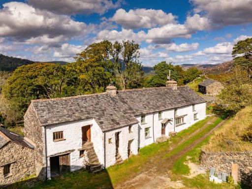 3 bedroom detached house for sale in Low Whineray Ground, Broughton-In-Furness, The Lake District, LA20 6DS, LA20 — £750,000 • 3 bed • 2 bath • 4283 ft²
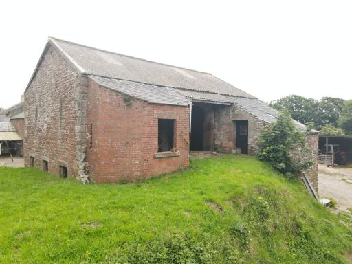 Barn conversion for sale in BANK BARN WITH DEVELOPMENT POTENTIAL At Kirklands Farm, Irton, Holmrook, CA19 — £120,000 • 1 bed • 1 bath • 1301 ft²
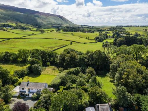 6 bedroom detached house for sale in Beckside Croft, Bootle, Lake District, Cumbria, LA19 5UQ, LA19 — £500,000 • 6 bed • 2 bath • 1960 ft²
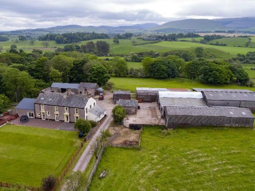 Farm for sale in Kidburngill Farm, Lamplugh, Cockermouth CA14 4RL, CA14 — £1,200,000 • 3 bed • 1 bath • 2979 ft²
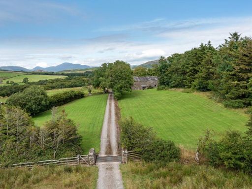 4 bedroom farm house for sale in Woodside House, Near Ravenglass, Cumbria, LA19 — £595,000 • 4 bed • 2 bath • 4494 ft²
Meta
- {
"@context": "https://schema.org",
"@type": "Residence",
"name": "3 bedroom bungalow for sale in Black How Farm, (Dawn View),…",
"description": "",
"url": "https://propertypiper.co.uk/property/20232845-921b-44dc-9ba3-d415ad2cee6a",
"image": "https://image-a.propertypiper.co.uk/a262210f-20a1-4008-aa6a-9b84b802e984-1024.jpeg",
"address": {
"@type": "PostalAddress",
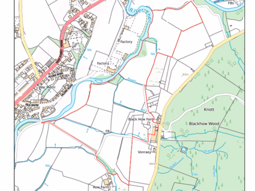
"streetAddress": "Row Farm",
"postalCode": "CA23 3EX",
"addressLocality": "Copeland",
"addressRegion": "Copeland",
"addressCountry": "England"
},
"geo": {
"@type": "GeoCoordinates",
"latitude": 54.5050233,
"longitude": -3.510955
},
"numberOfRooms": 3,
"numberOfBathroomsTotal": 2,
"floorSize": {
"@type": "QuantitativeValue",
"value": 1382,
"unitCode": "FTK"
},
"offers": {
"@type": "Offer",
"price": 695000,
"priceCurrency": "GBP",
"availability": "https://schema.org/InStock"
},
"additionalProperty": [
{
"@type": "PropertyValue",
"name": "Feature",
"value": "rural"
},
{
"@type": "PropertyValue",
"name": "Feature",
"value": "farmland"
},
{
"@type": "PropertyValue",
"name": "Feature",
"value": "countryside"
},
{
"@type": "PropertyValue",
"name": "Feature",
"value": "fields"
},
{
"@type": "PropertyValue",
"name": "Feature",
"value": "agricultural"
},
{
"@type": "PropertyValue",
"name": "Feature",
"value": "pasture"
},
{
"@type": "PropertyValue",
"name": "Feature",
"value": "trees"
},
{
"@type": "PropertyValue",
"name": "Feature",
"value": "scenic"
},
{
"@type": "PropertyValue",
"name": "Feature",
"value": "rolling hills"
},
{
"@type": "PropertyValue",
"name": "Feature",
"value": "open space"
},
{
"@type": "PropertyValue",
"name": "Feature",
"value": "land"
},
{
"@type": "PropertyValue",
"name": "Feature",
"value": " bungalow"
},
{
"@type": "PropertyValue",
"name": "Feature",
"value": "single-storey"
},
{
"@type": "PropertyValue",
"name": "Feature",
"value": "modern"
},
{
"@type": "PropertyValue",
"name": "Feature",
"value": "brick exterior"
},
{
"@type": "PropertyValue",
"name": "Feature",
"value": "pitch roof"
},
{
"@type": "PropertyValue",
"name": "Feature",
"value": "rural location"
},
{
"@type": "PropertyValue",
"name": "Feature",
"value": "fixer-upper"
},
{
"@type": "PropertyValue",
"name": "Feature",
"value": "neglected"
}
]
}
High Res Floorplan Images
Compatible Floorplan Images
FloorplanImages Thumbnail