M5 5AB - 2 bedroom flat for sale in Canterbury Gardens, Salford, M5
View on Property Piper
2 bedroom flat for sale in Canterbury Gardens, Salford, M5
Property Details
- Price: £129000
- Bedrooms: 2
- Bathrooms: 1
- Property Type: undefined
- Property SubType: undefined
Brochure Descriptions
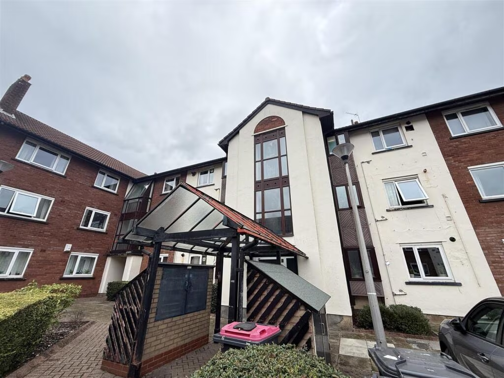
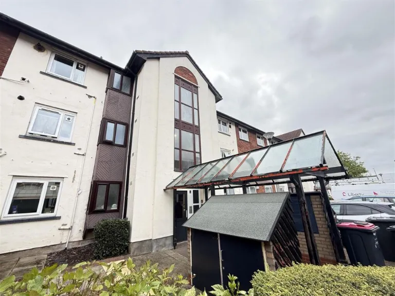
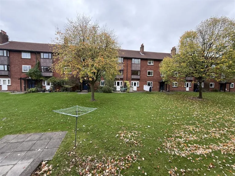
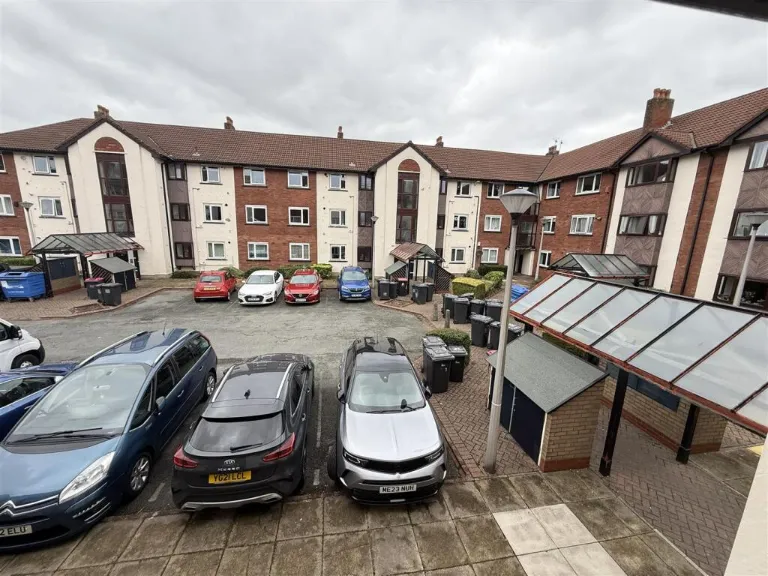
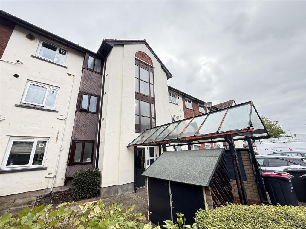
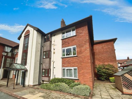
- Purpose‑built, mid‑height (3 storey) block of flats with communal entrance and covered entry canopy. The building has a rendered façade with some brick detailing and a glazed stair/light-well running up the centre. There is a small communal forecourt with bin/store and nearby on‑site/allocated parking visible to the front. The landscaped area is modest (small) and the property sits within a medium sized apartment development. Condition: external fabric appears generally sound but shows normal weathering and the glazed canopy and external joinery would benefit from cosmetic maintenance/repair. Likely accommodation type: an individual flat within a multi‑unit block (commonly one‑ or two‑bedroom flats in buildings of this style). No notable views (street/urban setting only) are visible from the images.
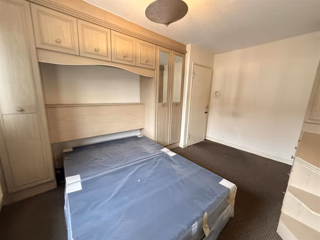
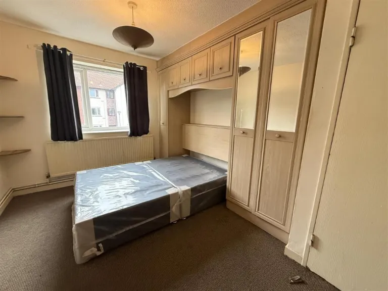
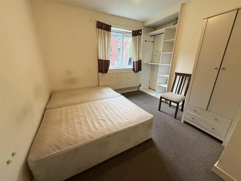
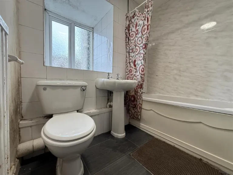
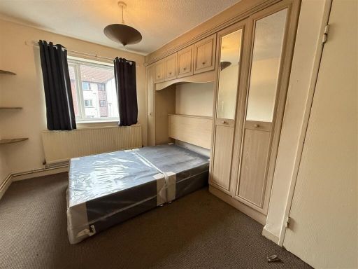
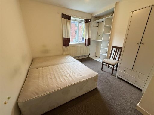
- Ground- or lower-floor flat within a red-brick purpose-built block, facing a communal landscaped lawn. Accommodation visible in images comprises two small double bedrooms (both with fitted/overbed storage in one room and freestanding wardrobes in the other), a small bathroom with bath, WC and pedestal basin, and likely a compact living/kitchen space (not pictured). Fixtures and finishes are dated but serviceable: carpeted bedrooms, older bathroom tiling and vinyl/dark floor covering in wet room. Rooms are modest in size (bedrooms = small; overall flat = small to average for a 1–2 bed flat). External communal grounds are spacious and well-kept, providing amenity value. From a valuer’s perspective the property offers reasonable rental/first‑time buyer appeal in a multi-unit block but will require modest cosmetic upgrading (new flooring, redecoration, updated bathroom fittings) to maximise market value. No exceptional views; setting is suburban with shared green space. Energy and structural condition not determinable from photos.
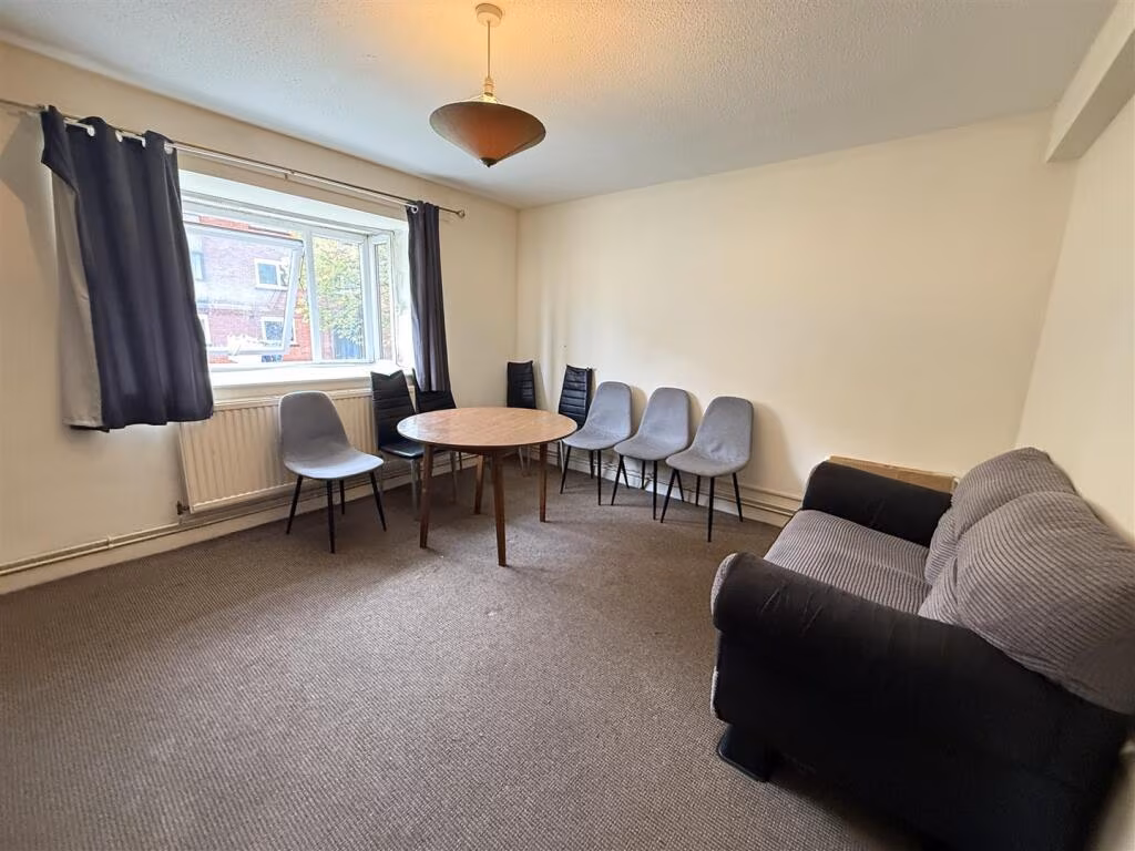
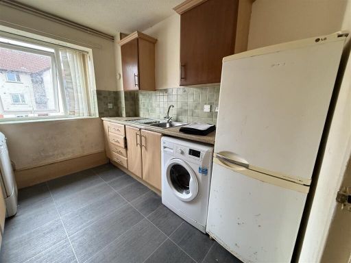
- First‑floor two‑bedroom flat in a purpose‑built block on Canterbury Gardens, Salford. The property offers a well‑sized reception room with views over the communal gardens, a fitted kitchen overlooking a courtyard, two generously proportioned bedrooms and a bathroom. Listed benefits include a communal garden, allocated parking space and a chain‑free sale. Accommodation and layout are typical of an urban apartment aimed at owner‑occupiers or landlords seeking an easy‑maintain city flat. Overall property footprint appears to be small‑to‑average for a two‑bedroom flat; communal outdoor space is of average size for a residential block and provides pleasant outlooks but no exceptional external amenity.
Image Descriptions
- apartment block 1980s apartment block
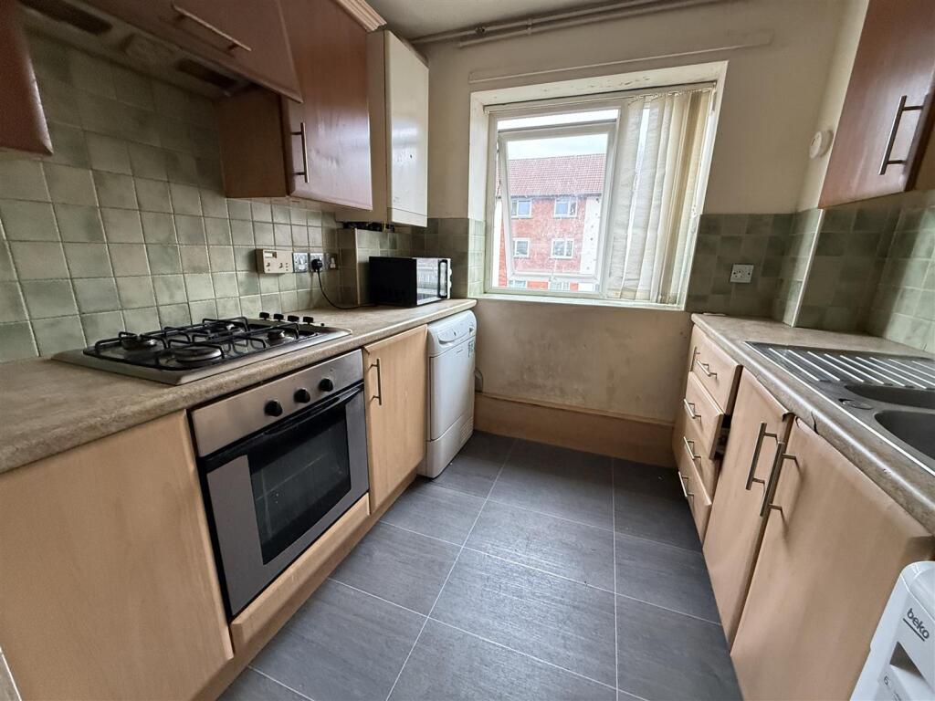
- kitchen Contemporary
Rooms
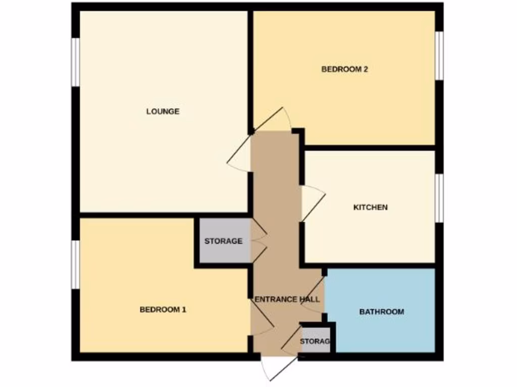
- LOUNGE:
- BEDROOM 2:
- KITCHEN:
- BEDROOM 1:
- STORAGE:
- ENTRANCE HALL:
- BATHROOM:
- STORAGE:
Textual Property Features
- Has Garden
- Chain Free
- Success
Detected Visual Features
- apartment
- block
- 1980s
- communal entrance
- multi-story
- investment
- exterior
- potential income
- urban
- apartment complex
- kitchen
- contemporary
- compact
- standard ceiling height
- gas stove
- tile flooring
- wall tiles
- needs modernization
- worn
- dated
EPC Details
- Fully double glazed
- Cavity wall, as built, partial insulation (assumed)
- Boiler and radiators, mains gas
- Low energy lighting in all fixed outlets
- (another dwelling below)
Nearby Schools
- St Augustine's CofE Primary School
- Lostock High School
- St Mary's RC Primary School
- King of Kings
- Branwood Preparatory School
- Light Oaks Junior School
- Summerville Primary School
- Grosvenor Road Primary School
- St Andrew's CofE Primary School
- St Luke's CofE Primary School
- All Hallows RC High School
- Ellesmere Park High School
- St John's CofE Primary School
- The Deans Primary School
- St Mary's RC Primary School
- Barton Clough Primary School
- Holy Family VA RC Primary School
- Monton Green Primary School
- Light Oaks Infant School
- St Luke's RC Primary School
- AldridgeUTC@MediaCityUK
- Willow Tree Primary School
- Clarendon Road Community Primary School
- Clarendon Cottage Preparatory School
Nearest General Shops
- Id: 9388736896
- Tags:
- Addr:
- Country: GB
- Housename: West One Retail Park
- Postcode: M50 1ZD
- Street: West One Way
- Unit: 9B
- Brand: Jollyes
- Brand:wikidata: Q45844955
- Name: Jollyes
- Shop: pet
- TagsNormalized:
- Lat: 53.4826718
- Lon: -2.3286992
- FullGeoHash: gcw2700r1ksh
- PartitionGeoHash: gcw2
- Images:
- FoodStandards: null
- Distance: 253.4
,- Id: 9388736897
- Tags:
- Addr:
- Country: GB
- Housename: West One Retail Park
- Postcode: M50 1ZD
- Street: West One Way
- Unit: 6
- Brand: Smyths
- Brand:wikidata: Q7546779
- Brand:wikipedia: en:Smyths
- Name: Smyths
- Shop: toys
- TagsNormalized:
- Lat: 53.4831539
- Lon: -2.3285034
- FullGeoHash: gcw27023vyw0
- PartitionGeoHash: gcw2
- Images:
- FoodStandards: null
- Distance: 200.5
,- Id: 67157525
- Tags:
- Addr:
- City: Salford
- Country: GB
- Housename: West One Retail Park
- Postcode: M50 1ZD
- Street: Eccles New Road
- Unit: 1-5
- Brand: The Range
- Brand:wikidata: Q7759409
- Brand:wikipedia: en:The Range (retailer)
- Building: retail
- Name: The Range
- Shop: houseware
- Website: https://www.therange.co.uk/
- TagsNormalized:
- the range
- retail
- houseware
- shop
- Lat: 53.4835337
- Lon: -2.329235
- FullGeoHash: gcw26bruhvk9
- PartitionGeoHash: gcw2
- Images:
- FoodStandards: null
- Distance: 160.5
}
Nearest Grocery shops
- Id: 4713185968
- Tags:
- Addr:
- City: Salford
- Housenumber: 215
- Postcode: M6 8HA
- Street: Eccles Old Road
- Brand: Premier
- Brand:wikidata: Q7240340
- Brand:wikipedia: en:Premier Stores
- Fhrs:
- Name: Premier
- Opening_hours: Mo-Su 07:00-22:00
- Shop: convenience
- Source:
- TagsNormalized:
- Lat: 53.4888124
- Lon: -2.3268004
- FullGeoHash: gcw2713dvt7f
- PartitionGeoHash: gcw2
- Images:
- FoodStandards:
- Id: 94732
- FHRSID: 94732
- LocalAuthorityBusinessID: 279
- BusinessName: Premier Stores
- BusinessType: Retailers - other
- BusinessTypeID: 4613
- AddressLine1: null
- AddressLine2: 215 Eccles Old Road
- AddressLine3: Salford
- AddressLine4: null
- PostCode: M6 8HA
- RatingValue: 5
- RatingKey: fhrs_5_en-GB
- RatingDate: 2023-01-31
- LocalAuthorityCode: 422
- LocalAuthorityName: Salford
- LocalAuthorityWebSite: http://www.salford.gov.uk/envhealth.htm
- LocalAuthorityEmailAddress: environmentalhealth@salford.gov.uk
- Scores:
- Hygiene: 5
- Structural: 5
- ConfidenceInManagement: 5
- NewRatingPending: false
- Geocode:
- Longitude: -2.32623700000000
- Latitude: 53.48880400000000
- Distance: 448.8
,- Id: 9378697531
- Tags:
- Brand: Sainsbury's Local
- Brand:wikidata: Q13218434
- Brand:wikipedia: en:Sainsbury's Local
- Name: Sainsbury's Local
- Shop: convenience
- TagsNormalized:
- sainsburys
- sainsburys local
- convenience
- shop
- Lat: 53.488033
- Lon: -2.3293129
- FullGeoHash: gcw26cpy7h43
- PartitionGeoHash: gcw2
- Images:
- FoodStandards: null
- Distance: 344.6
,- Id: 9388736895
- Tags:
- Addr:
- Country: GB
- Housename: West One Retail Park
- Postcode: M50 1ZD
- Street: West One Way
- Unit: 10
- Brand: The Food Warehouse
- Brand:wikidata: Q87263899
- Brand:wikipedia: en:The Food Warehouse
- Name: The Food Warehouse
- Shop: supermarket
- TagsNormalized:
- food
- the food warehouse
- warehouse
- shop
- Lat: 53.4824691
- Lon: -2.328718
- FullGeoHash: gcw2700mbyy5
- PartitionGeoHash: gcw2
- Images:
- FoodStandards: null
- Distance: 275.9
}
Nearest Religious buildings
- Id: 256755021
- Tags:
- Amenity: place_of_worship
- Building: church
- Denomination: anglican
- Name: St James, Hope
- Religion: christian
- Wikidata: Q26665877
- TagsNormalized:
- place of worship
- church
- anglican
- christian
- Lat: 53.4889428
- Lon: -2.3200427
- FullGeoHash: gcw271qeejdu
- PartitionGeoHash: gcw2
- Images:
- FoodStandards: null
- Distance: 728.3
,- Id: 4713185972
- Tags:
- Amenity: place_of_worship
- Name: Elmwood Church
- Node_id: 4713185972
- Religion: christian
- Source:
- Name: OS Open Local Important Buildings Layer
- TagsNormalized:
- place of worship
- church
- christian
- Lat: 53.4895723
- Lon: -2.3227012
- FullGeoHash: gcw271kxm4ur
- PartitionGeoHash: gcw2
- Images:
- FoodStandards: null
- Distance: 652.2
,- Id: 94366374
- Tags:
- Amenity: place_of_worship
- Building: church;yes
- Denomination: anglican
- Name: Eccles Parish, St Mary the Virgin;St Mary The Virgin
- Religion: christian
- Wikidata: Q5117592
- Wikipedia: en:Church of St Mary the Virgin, Eccles
- TagsNormalized:
- place of worship
- church
- anglican
- parish
- christian
- Lat: 53.4844289
- Lon: -2.3346537
- FullGeoHash: gcw26becqshj
- PartitionGeoHash: gcw2
- Images:
- FoodStandards: null
- Distance: 393.6
}
Nearest Medical buildings
- Id: 9032789350
- Tags:
- Amenity: pharmacy
- Brand: Lloyds Pharmacy
- Brand:wikidata: Q6662870
- Brand:wikipedia: en:LloydsPharmacy
- Dispensing: yes
- Healthcare: pharmacy
- Name: Lloyds Pharmacy
- TagsNormalized:
- pharmacy
- lloyds pharmacy
- health
- healthcare
- Lat: 53.488433
- Lon: -2.3238853
- FullGeoHash: gcw2717b9w9e
- PartitionGeoHash: gcw2
- Images:
- FoodStandards: null
- Distance: 504.4
,- Id: 4713185973
- Tags:
- Amenity: pharmacy
- Brand: Well Pharmacy
- Brand:wikidata: Q7726524
- Healthcare: pharmacy
- Name: Well Pharmacy
- TagsNormalized:
- pharmacy
- well pharmacy
- health
- healthcare
- Lat: 53.4888409
- Lon: -2.3263041
- FullGeoHash: gcw2716514tu
- PartitionGeoHash: gcw2
- Images:
- FoodStandards: null
- Distance: 462.3
,- Id: 10696465868
- Tags:
- Amenity: restaurant
- Brand: Well Pharmacy
- Cuisine: chinese
- Name: Golden Kitchen
- TagsNormalized:
- restaurant
- pharmacy
- well pharmacy
- chinese
- kitchen
- Lat: 53.4888368
- Lon: -2.3263872
- FullGeoHash: gcw2713gp1zg
- PartitionGeoHash: gcw2
- Images:
- FoodStandards: null
- Distance: 460
,- Id: 502769634
- Tags:
- Addr:
- Postcode: M6 8HD
- Street: Stott Lane
- Alt_name: Hope Hospital
- Amenity: hospital
- Healthcare: hospital
- Name: Salford Royal Hospital
- Note: replacing nodes & buildings tagged hospital
- Phone: +44 161 789 7373
- Source: Bing
- Website: https://www.srft.nhs.uk/
- Wikidata: Q50575528
- Wikipedia: en:Salford Royal Hospital
- TagsNormalized:
- Lat: 53.4872813
- Lon: -2.3243147
- FullGeoHash: gcw27153zxcm
- PartitionGeoHash: gcw2
- Images:
- FoodStandards: null
- Distance: 392.5
}
Nearest Airports
- Id: 1224469
- Tags:
- Addr:
- City: Manchester
- Country: GB
- Postcode: M90 1QX
- Aerodrome: international
- Aeroway: aerodrome
- Arp: yes
- Atis: 128.175
- Iata: MAN
- Icao: EGCC
- Name: Manchester Airport
- Note: rough sketched outline referring to Yahoo imagery - true boundary is where?
- Old_name: Ringway
- Operator: Manchester Airport PLC
- Size: 18720000
- Source:
- Tower_frequency: 118.625,119.400
- Type: multipolygon
- Website: https://www.manchesterairport.co.uk/
- Wikidata: Q8694
- Wikipedia: en:Manchester Airport
- TagsNormalized:
- airport
- international airport
- Lat: 53.3503197
- Lon: -2.2798822
- FullGeoHash: gcqrs05u4ukt
- PartitionGeoHash: gcqr
- Images:
- FoodStandards: null
- Distance: 15316.8
}
Nearest Leisure Facilities
- Id: 185100086
- Tags:
- Addr:
- City: Salford
- Postcode: M30 0DD
- Street: Barton Lane
- Building: yes
- Email: ecclesleisurecentre@scll.co.uk
- Leisure: sports_centre
- Name: Eccles Leisure Centre
- Opening_hours: Mo-Th 06:15-22:00; Fr 06:15-20:15; Sa-Su 07:00-17:00
- Operator: Salford City Council
- Phone: +44 161 787 7107
- SccLeisureCentre:
- Source: data.gov.uk
- Sport: swimming;multi;fitness_centre
- Website: https://www.salfordcommunityleisure.co.uk/sport/locations/eccles-leisure-centre
- TagsNormalized:
- sports
- sports centre
- leisure
- swimming
- fitness
- fitness centre
- Lat: 53.4818948
- Lon: -2.3389589
- FullGeoHash: gcw26b0fd7cc
- PartitionGeoHash: gcw2
- Images:
- FoodStandards: null
- Distance: 755
,- Id: 479595466
- Tags:
- TagsNormalized:
- Lat: 53.4914584
- Lon: -2.3315006
- FullGeoHash: gcw26cy624e4
- PartitionGeoHash: gcw2
- Images:
- FoodStandards: null
- Distance: 745.9
,- Id: 27930364
- Tags:
- TagsNormalized:
- Lat: 53.4864613
- Lon: -2.3188657
- FullGeoHash: gcw270zmnx03
- PartitionGeoHash: gcw2
- Images:
- FoodStandards: null
- Distance: 676.5
,- Id: 976071926
- Tags:
- Access: permissive
- Leisure: garden
- TagsNormalized:
- Lat: 53.4873841
- Lon: -2.3239418
- FullGeoHash: gcw2715f85p6
- PartitionGeoHash: gcw2
- Images:
- FoodStandards: null
- Distance: 418.6
,- Id: 185112759
- Tags:
- TagsNormalized:
- Lat: 53.4842137
- Lon: -2.333991
- FullGeoHash: gcw26bs2nh44
- PartitionGeoHash: gcw2
- Images:
- FoodStandards: null
- Distance: 355.1
}
Nearest Tourist attractions
- Id: 961697213
- Tags:
- Addr:
- City: Manchester
- Postcode: M17 1TZ
- Street: Trafford Wharf Road
- Alt_name: IWM North
- Fee: no
- Landuse: commercial
- Name: Imperial War Museum North
- Opening_hours: Mo-Su 10:00-17:00
- Tourism: museum
- Website: https://www.iwm.org.uk/visits/iwm-north
- Wheelchair: yes
- Wikipedia: en:Imperial War Museum North
- TagsNormalized:
- Lat: 53.4697469
- Lon: -2.2990841
- FullGeoHash: gcw25tvgg7q8
- PartitionGeoHash: gcw2
- Images:
- FoodStandards: null
- Distance: 2591.7
,- Id: 1052332564
- Tags:
- Area: yes
- Name: LEGOLAND Discovery Centre
- Tourism: attraction
- TagsNormalized:
- Lat: 53.4673502
- Lon: -2.3416478
- FullGeoHash: gcw24tqvgskz
- PartitionGeoHash: gcw2
- Images:
- FoodStandards: null
- Distance: 2134.6
,- Id: 1052332562
- Tags:
- Name: Sea Life Manchester
- Tourism: aquarium
- TagsNormalized:
- Lat: 53.4677985
- Lon: -2.341026
- FullGeoHash: gcw24tx2d0h3
- PartitionGeoHash: gcw2
- Images:
- FoodStandards: null
- Distance: 2072.5
}
Nearest Hotels
- Id: 1515837549
- Tags:
- Amenity: pub
- Name: Park Hotel
- Opening_hours: Mo-Su 12:00-22:30
- Operator: Joseph Holt
- TagsNormalized:
- Lat: 53.490569
- Lon: -2.3500358
- FullGeoHash: gcw2698v0hy2
- PartitionGeoHash: gcw2
- Images:
- FoodStandards: null
- Distance: 1539.5
,- Id: 185097366
- Tags:
- Brand: Milton
- Building: yes
- Building:levels: 15
- Name: Milton Manchester
- Tourism: hotel
- TagsNormalized:
- Lat: 53.484309
- Lon: -2.3390038
- FullGeoHash: gcw26b8b9mb6
- PartitionGeoHash: gcw2
- Images:
- FoodStandards: null
- Distance: 680.9
,- Id: 196933227
- Tags:
- Addr:
- City: Salford
- Housenumber: 33
- Postcode: M30 0BP
- Street: Regent Street
- Amenity: pub
- Building: yes
- Fhrs:
- Name: Lamb Hotel
- Operator: Joseph Holt
- Source:
- Wikidata: Q18160491
- Wikipedia: en:Lamb Hotel, Eccles
- TagsNormalized:
- Lat: 53.4834596
- Lon: -2.3334427
- FullGeoHash: gcw26bkgdz7p
- PartitionGeoHash: gcw2
- Images:
- FoodStandards: null
- Distance: 350.8
}
Tags
- apartment
- block
- 1980s
- communal entrance
- multi-story
- investment
- exterior
- potential income
- urban
- apartment complex
- kitchen
- contemporary
- compact
- standard ceiling height
- gas stove
- tile flooring
- wall tiles
- needs modernization
- worn
- dated
Local Market Stats
- Average Price/sqft: £303
- Avg Income: £42400
- Rental Yield: 6.5%
- Social Housing: 31%
- Planning Success Rate: 88%
AirBnB Data
- 1km average: £70/night
- Listings in 1km: 4
Similar Properties
 2 bedroom flat for sale in Knights Court, Canterbury Gardens, Salford, M5 — £110,000 • 2 bed • 1 bath • 567 ft²
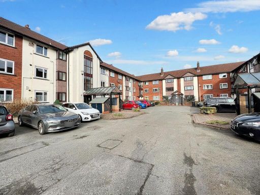 2 bedroom flat for sale in Canterbury Gardens, Reeves Court, M5 — £90,000 • 2 bed • 1 bath • 657 ft²
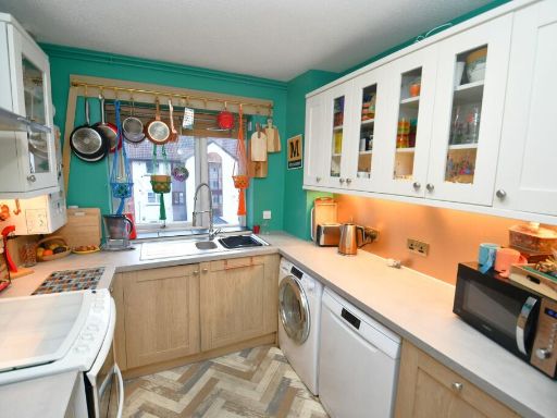 2 bedroom flat for sale in Canterbury Gardens, Squires Court, M5 — £110,000 • 2 bed • 1 bath • 571 ft²
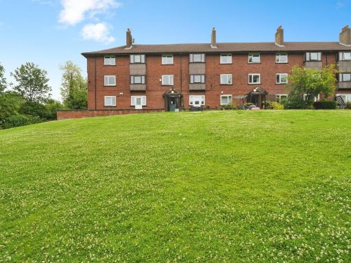 3 bedroom apartment for sale in Canterbury Gardens, Salford, M5 — £120,000 • 3 bed • 1 bath • 931 ft²
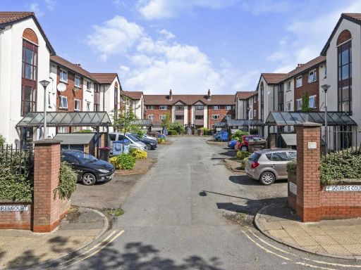 3 bedroom apartment for sale in Canterbury Gardens, Salford, Greater Manchester, M5 — £110,000 • 3 bed • 1 bath • 906 ft²
 2 bedroom flat for sale in Nevile Court, Salford, M7 — £125,000 • 2 bed • 1 bath • 695 ft²
Meta
- {
"@context": "https://schema.org",
"@type": "Residence",
"name": "2 bedroom flat for sale in Canterbury Gardens, Salford, M5",
"description": "",
"url": "https://propertypiper.co.uk/property/117c7267-c67c-4ea7-891f-4434be9cf2b0",
"image": "https://image-a.propertypiper.co.uk/5d9de265-9c4a-4760-823f-8e2f158341e9-1024.jpeg",
"address": {
"@type": "PostalAddress",
"streetAddress": "KNIGHTS COURT FLAT 40 CANTERBURY GARDENS SALFORD ",
"postalCode": "M5 5AB",
"addressLocality": "Salford",
"addressRegion": "Salford and Eccles",
"addressCountry": "England"
},
"geo": {
"@type": "GeoCoordinates",
"latitude": 53.48495040162755,
"longitude": -2.328769458471146
},
"numberOfRooms": 2,
"numberOfBathroomsTotal": 1,
"floorSize": {
"@type": "QuantitativeValue",
"value": 679,
"unitCode": "FTK"
},
"offers": {
"@type": "Offer",
"price": 129000,
"priceCurrency": "GBP",
"availability": "https://schema.org/InStock"
},
"additionalProperty": [
{
"@type": "PropertyValue",
"name": "Feature",
"value": "apartment"
},
{
"@type": "PropertyValue",
"name": "Feature",
"value": "block"
},
{
"@type": "PropertyValue",
"name": "Feature",
"value": "1980s"
},
{
"@type": "PropertyValue",
"name": "Feature",
"value": "communal entrance"
},
{
"@type": "PropertyValue",
"name": "Feature",
"value": "multi-story"
},
{
"@type": "PropertyValue",
"name": "Feature",
"value": "investment"
},
{
"@type": "PropertyValue",
"name": "Feature",
"value": "exterior"
},
{
"@type": "PropertyValue",
"name": "Feature",
"value": "potential income"
},
{
"@type": "PropertyValue",
"name": "Feature",
"value": "urban"
},
{
"@type": "PropertyValue",
"name": "Feature",
"value": "apartment complex"
},
{
"@type": "PropertyValue",
"name": "Feature",
"value": "kitchen"
},
{
"@type": "PropertyValue",
"name": "Feature",
"value": "contemporary"
},
{
"@type": "PropertyValue",
"name": "Feature",
"value": "compact"
},
{
"@type": "PropertyValue",
"name": "Feature",
"value": "standard ceiling height"
},
{
"@type": "PropertyValue",
"name": "Feature",
"value": "gas stove"
},
{
"@type": "PropertyValue",
"name": "Feature",
"value": "tile flooring"
},
{
"@type": "PropertyValue",
"name": "Feature",
"value": "wall tiles"
},
{
"@type": "PropertyValue",
"name": "Feature",
"value": "needs modernization"
},
{
"@type": "PropertyValue",
"name": "Feature",
"value": "worn"
},
{
"@type": "PropertyValue",
"name": "Feature",
"value": "dated"
}
]
}
High Res Floorplan Images
Compatible Floorplan Images
FloorplanImages Thumbnail