SK17 9AD - 3 bedroom semidetached house for sale in Macclesfield Road,…
View on Property Piper
3 bedroom semi-detached house for sale in Macclesfield Road, Buxton, SK17
Property Details
- Price: £350000
- Bedrooms: 3
- Bathrooms: 1
- Property Type: undefined
- Property SubType: undefined
Brochure Descriptions
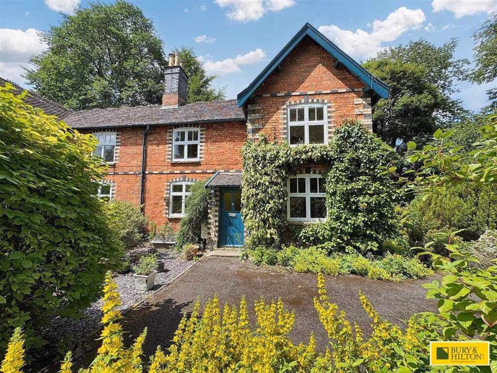
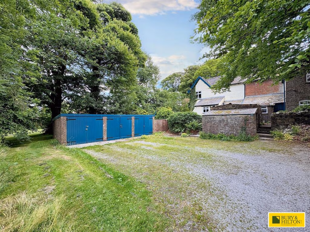
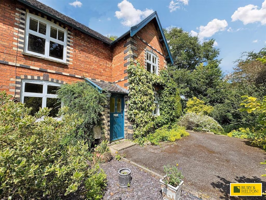
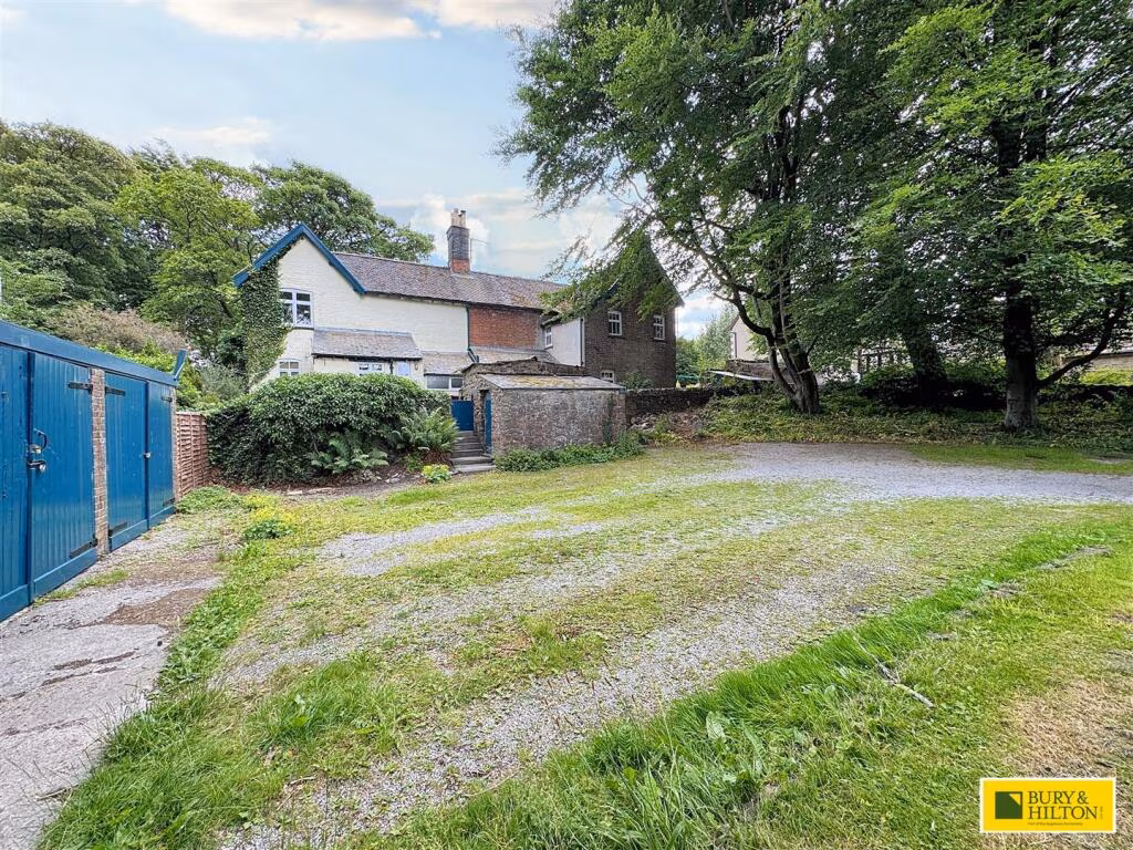
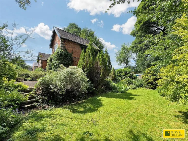
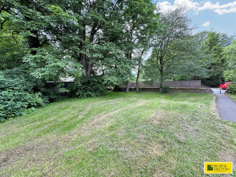
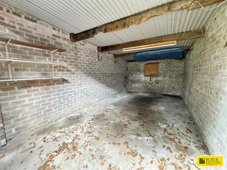
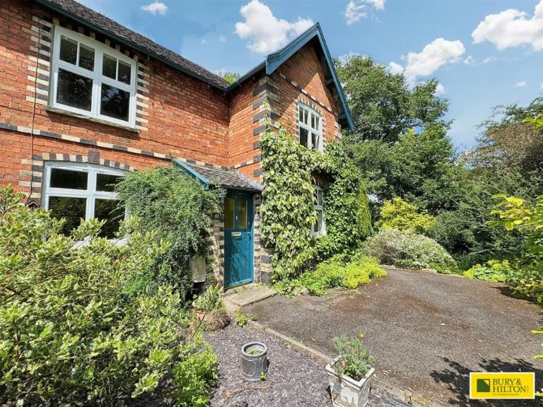
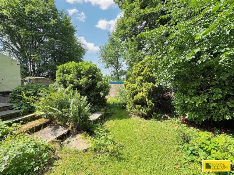
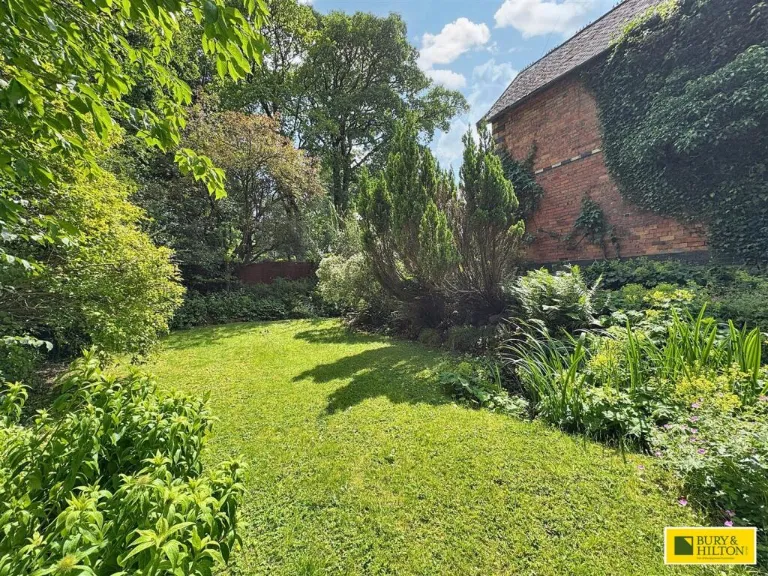
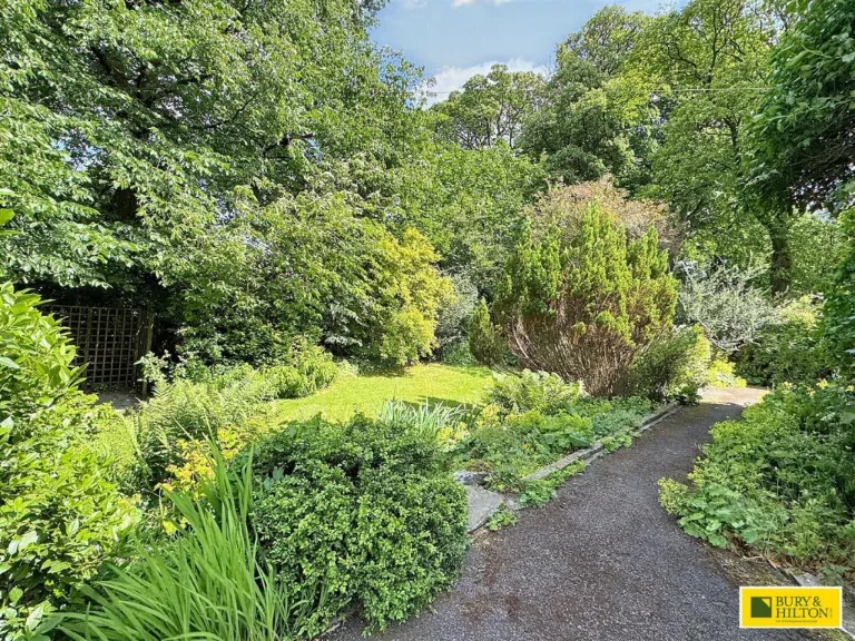
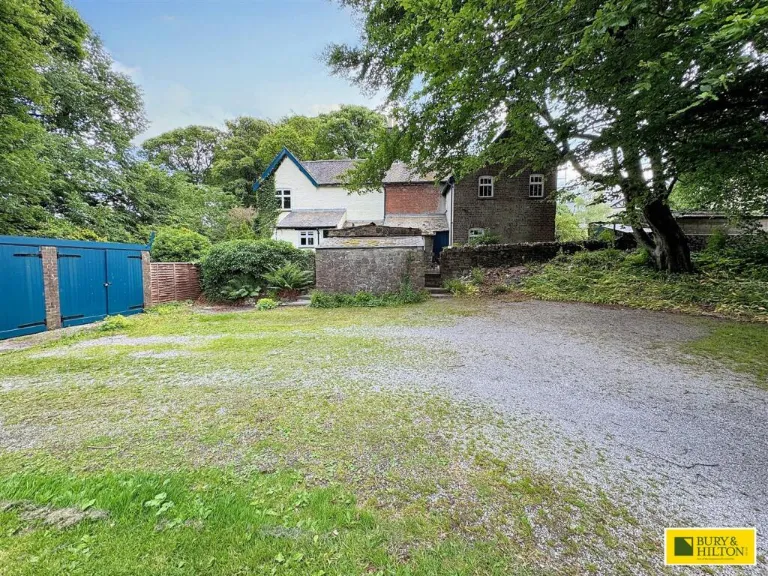
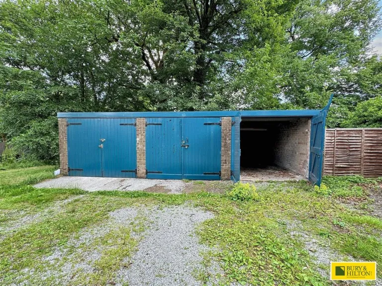
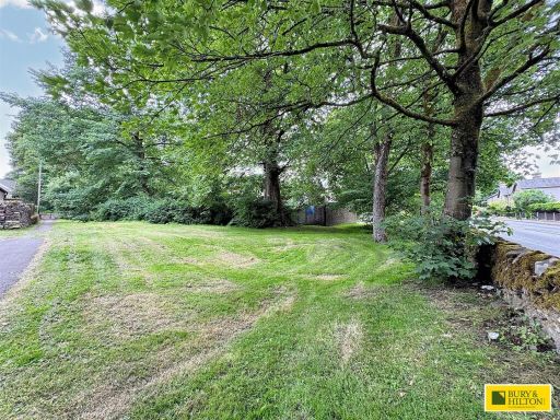
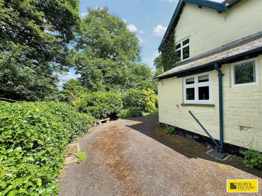
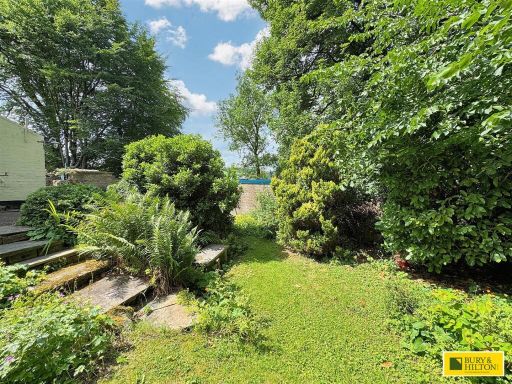
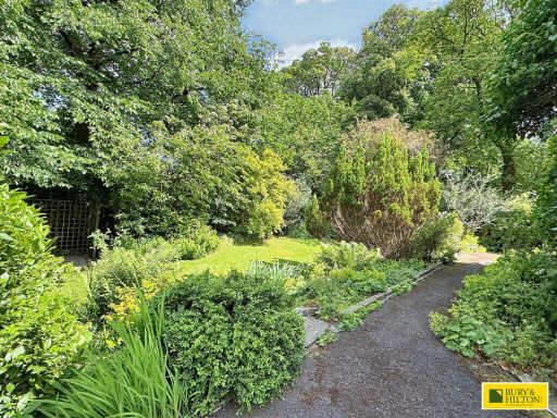
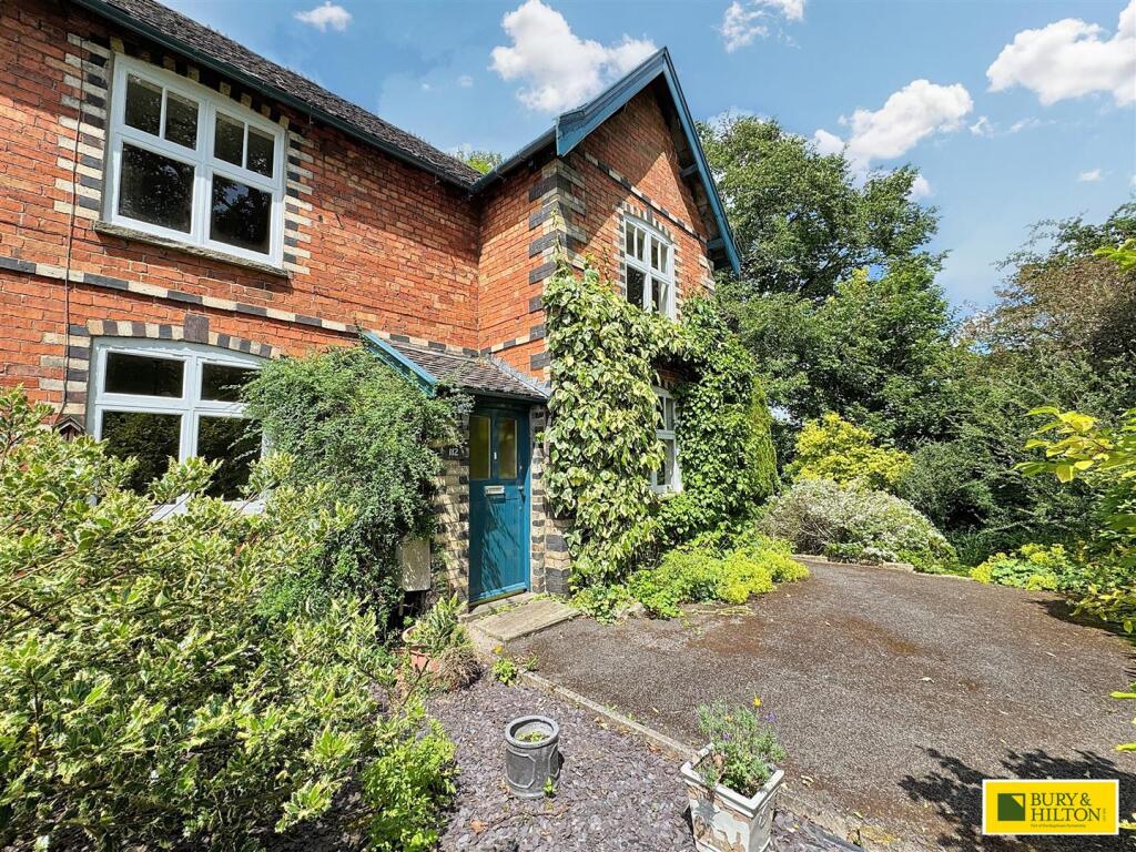
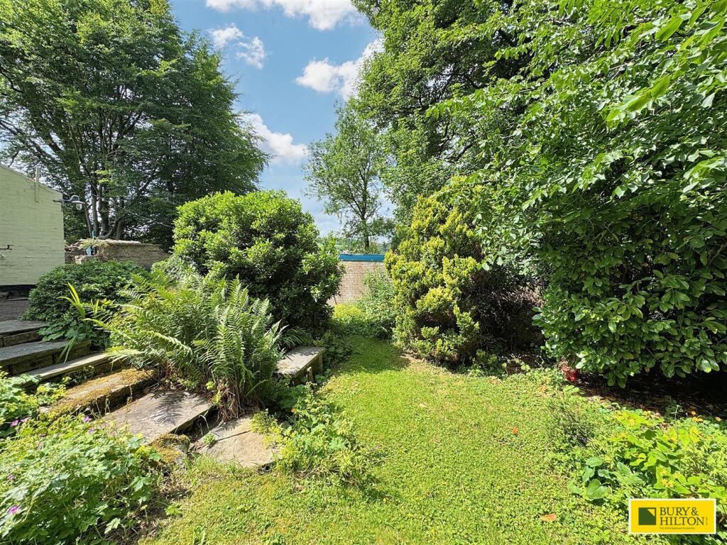
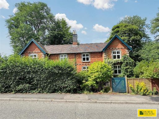
- Period red-brick semi-detached/terraced cottage style house (two storeys with gabled attic) set within mature grounds. The principal elevation shows traditional sash-style windows, an entrance porch and substantial ivy/climbing growth. The property sits behind a gravel/bitmac drive with an established front garden and well-stocked borders. Ancillary outbuildings include a range of single garages and a sizeable parking/turning forecourt. The site is bordered by mature trees and woodland giving private, sheltered and largely green outlooks — attractive for those seeking a rural/suburban setting close to Buxton. Garden size: large. Overall property footprint and internal size appear to be medium/large but exact internal floor area not stated.
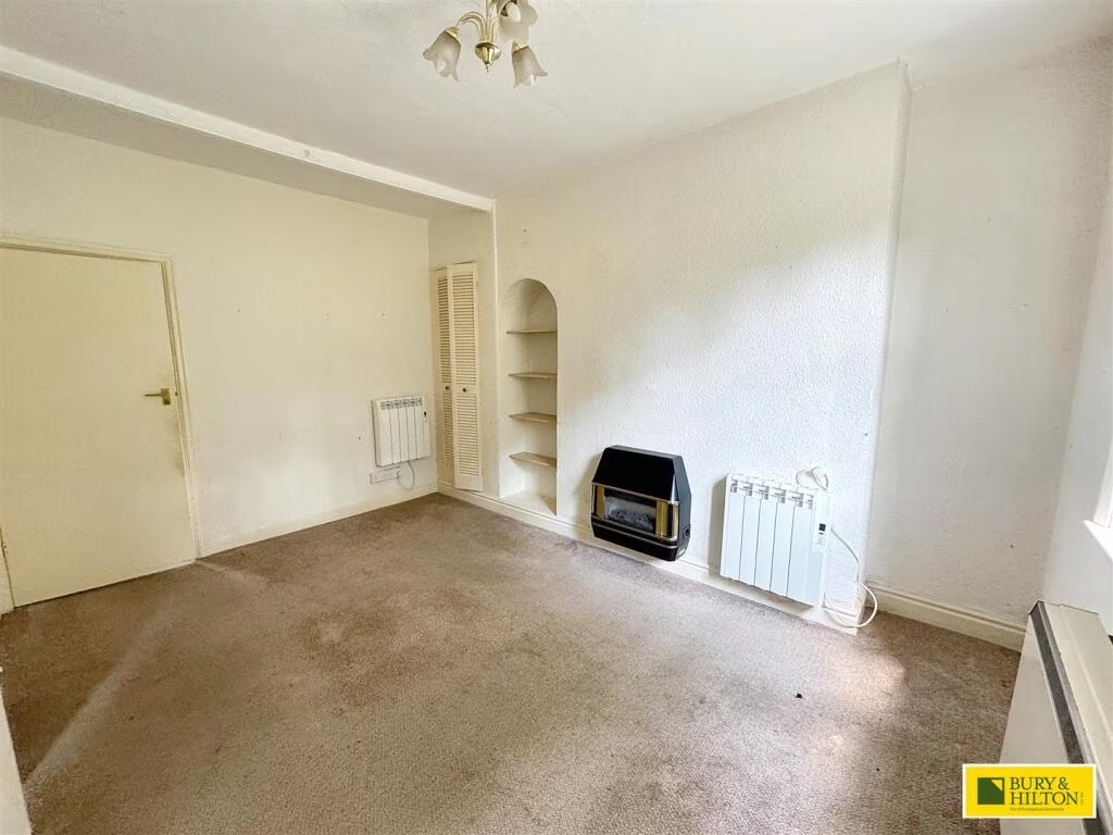
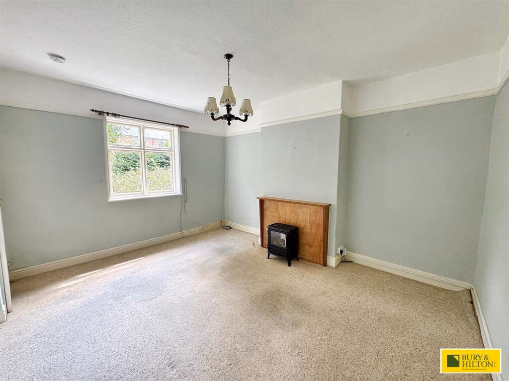
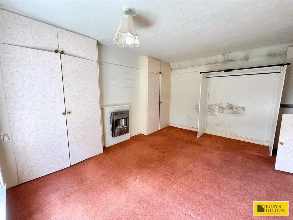
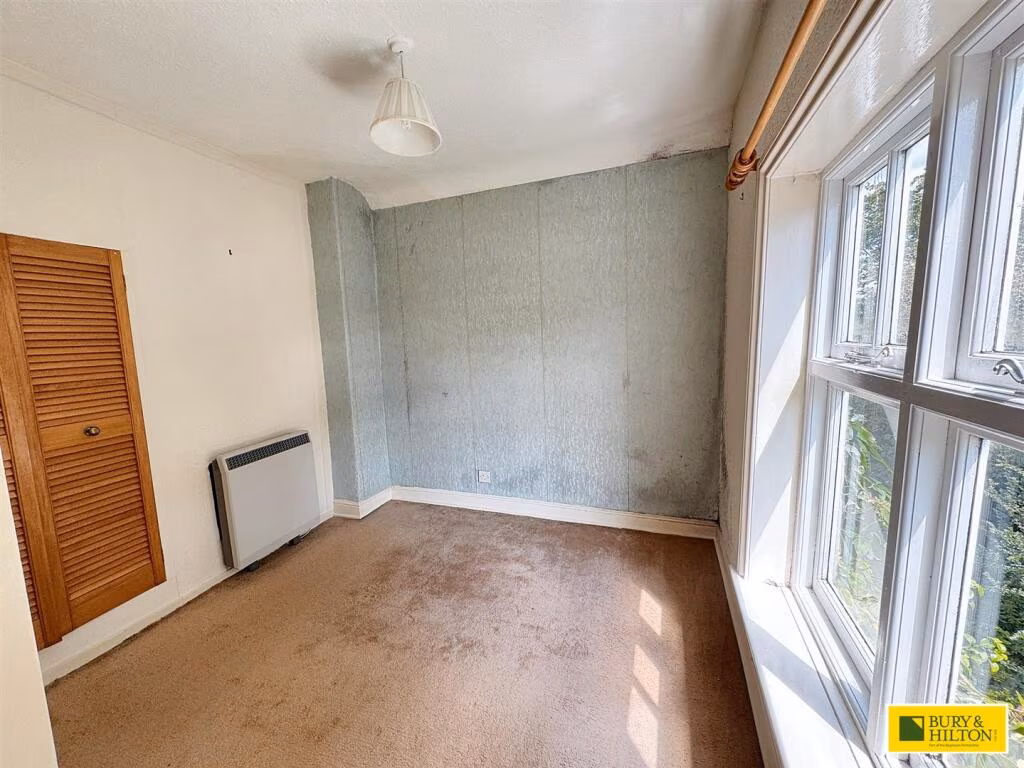
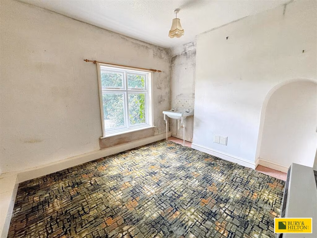
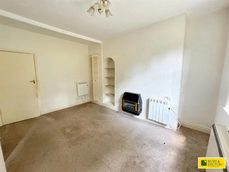
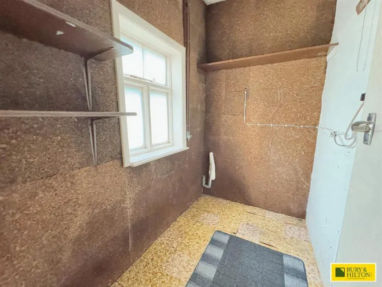
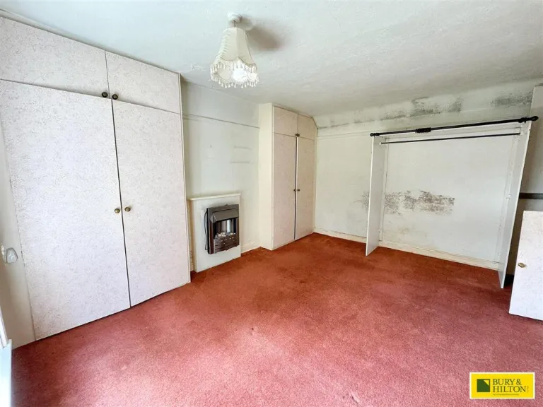
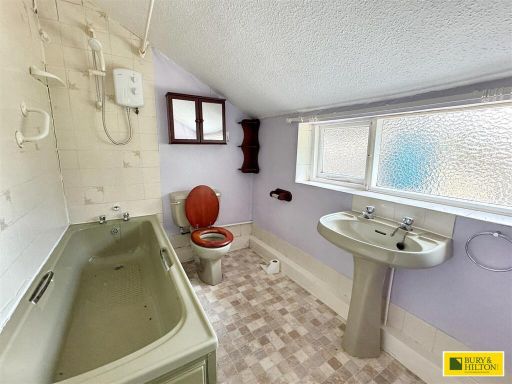
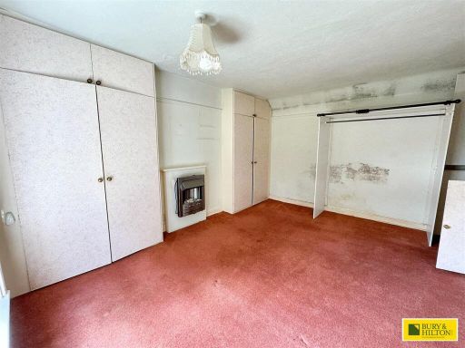
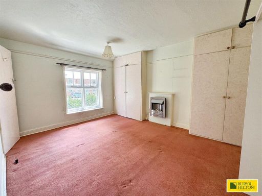
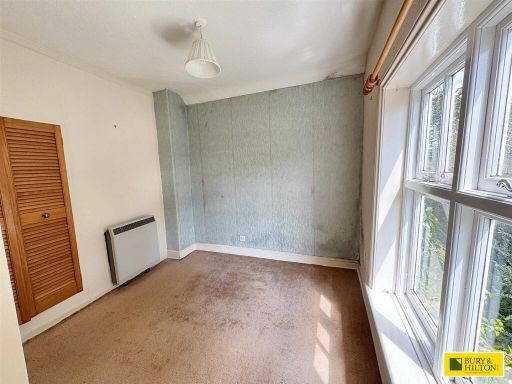
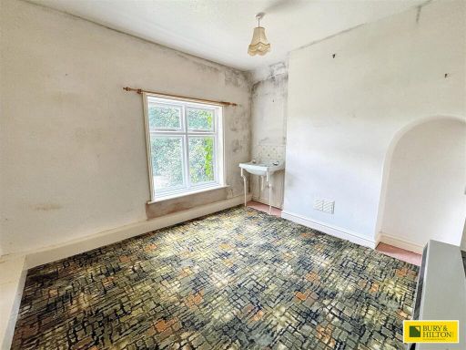
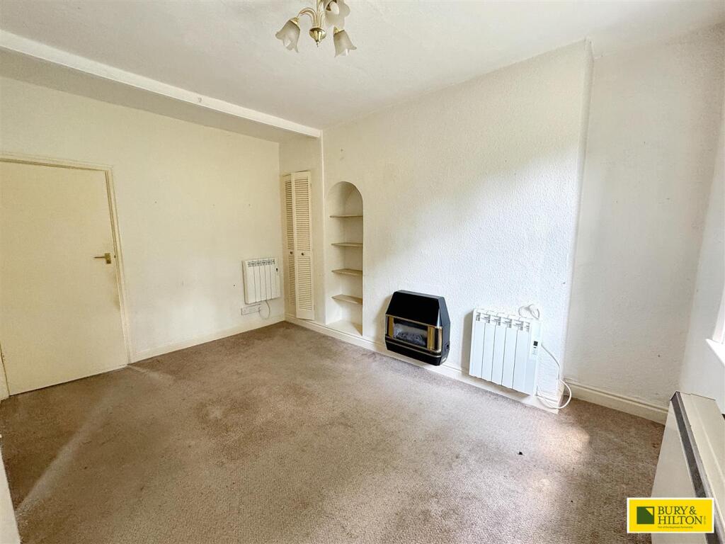
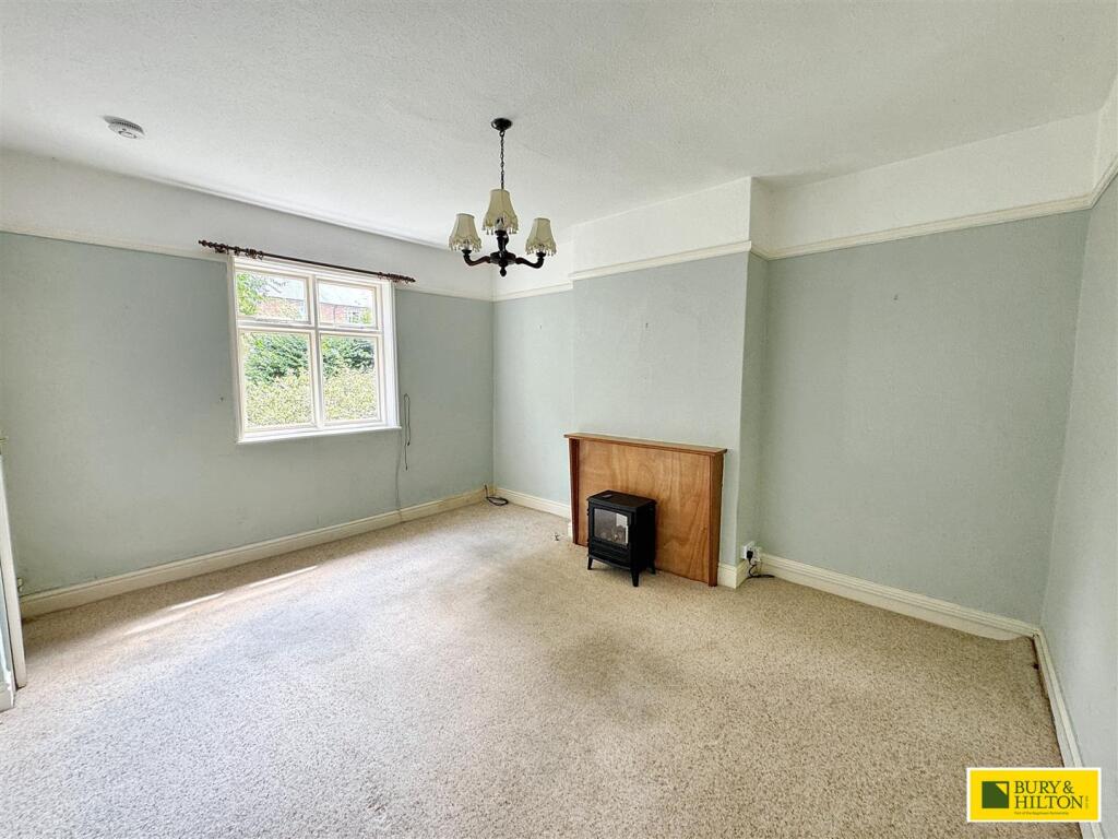
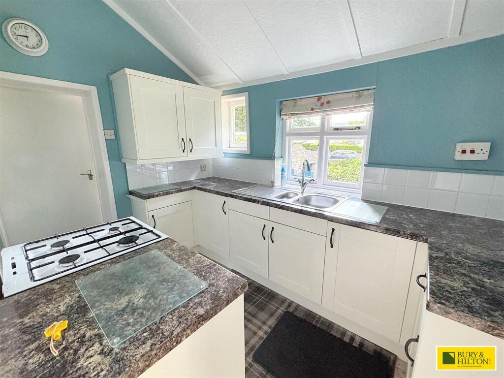
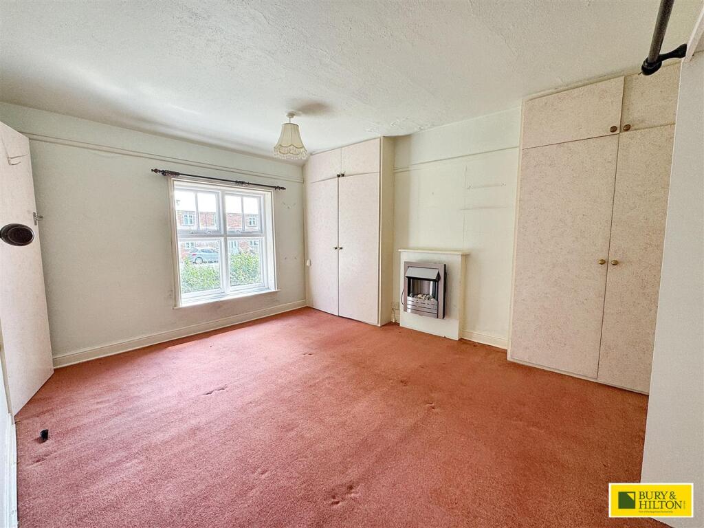
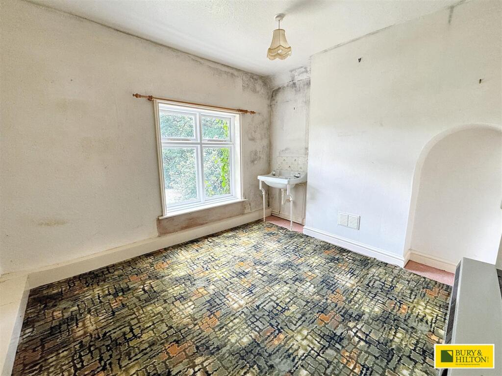
- Three-bedroom semi-detached house with land to the rear including a detached garage. The property offers two reception rooms, a kitchen, utility and a family bathroom, with first-floor landing and three bedrooms. Interior condition appears dated and in need of modernisation/decoration. Garden to the rear is average in size for a town plot. Overall property size is average for a three-bedroom semi in a suburban/town setting; views are typical street/urban views with neighbouring housing.
Image Descriptions
- A charming two-story cottage surrounded by greenery. Victorian
- exterior of a residential property Traditional
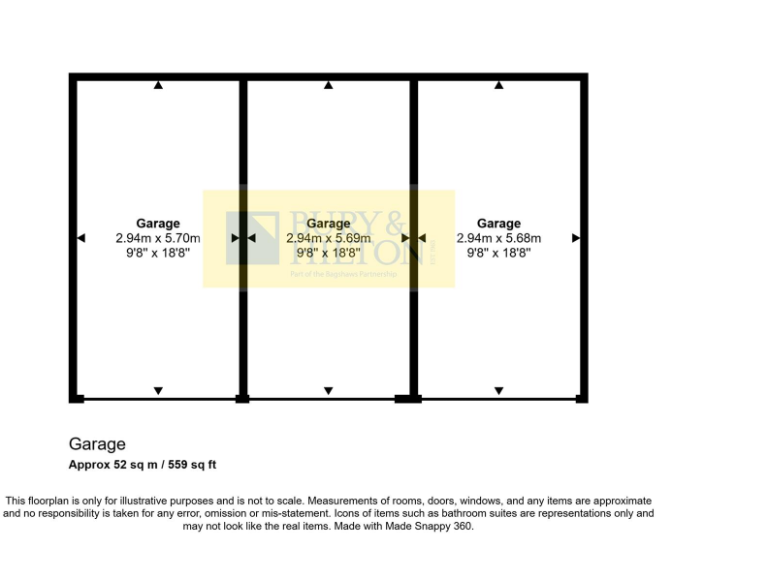
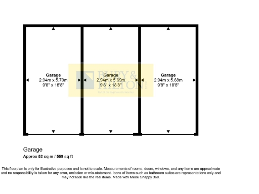
Floorplan Description
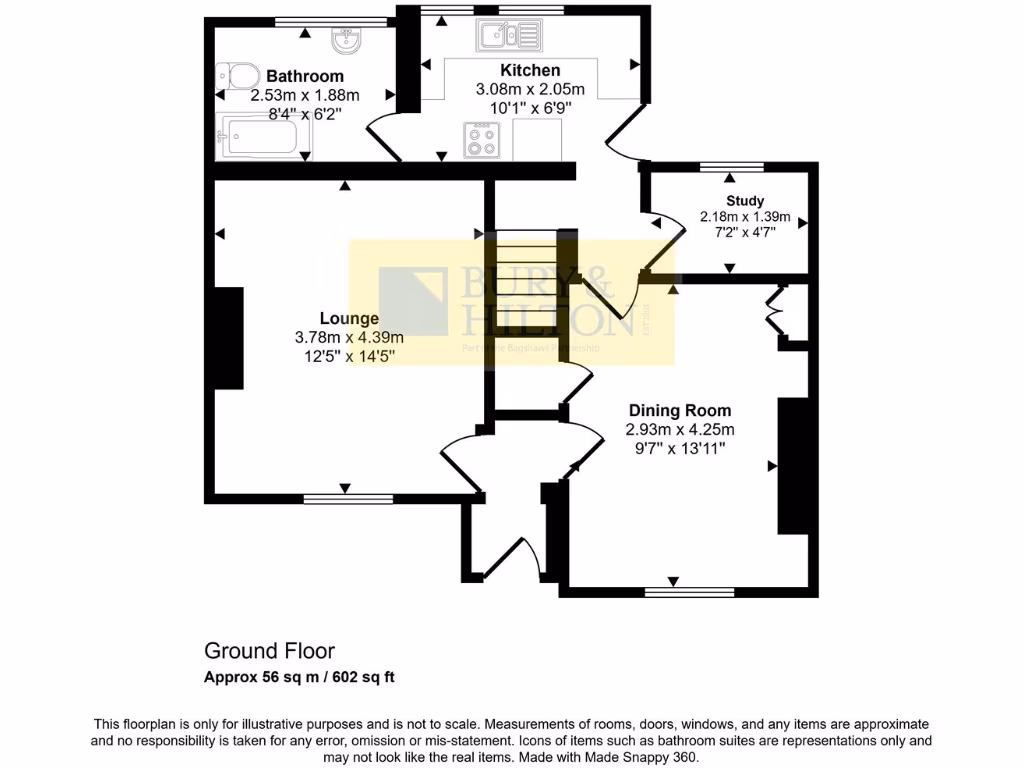
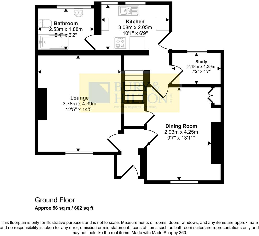
- Ground floor plan showing lounge, dining room, kitchen, bathroom and study.
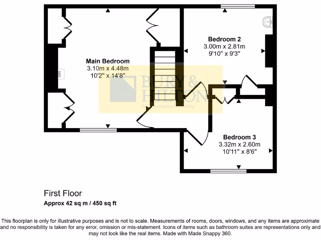
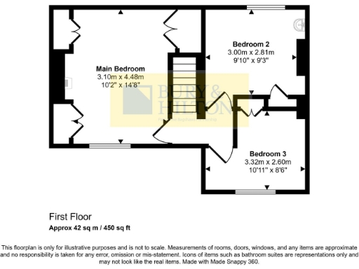
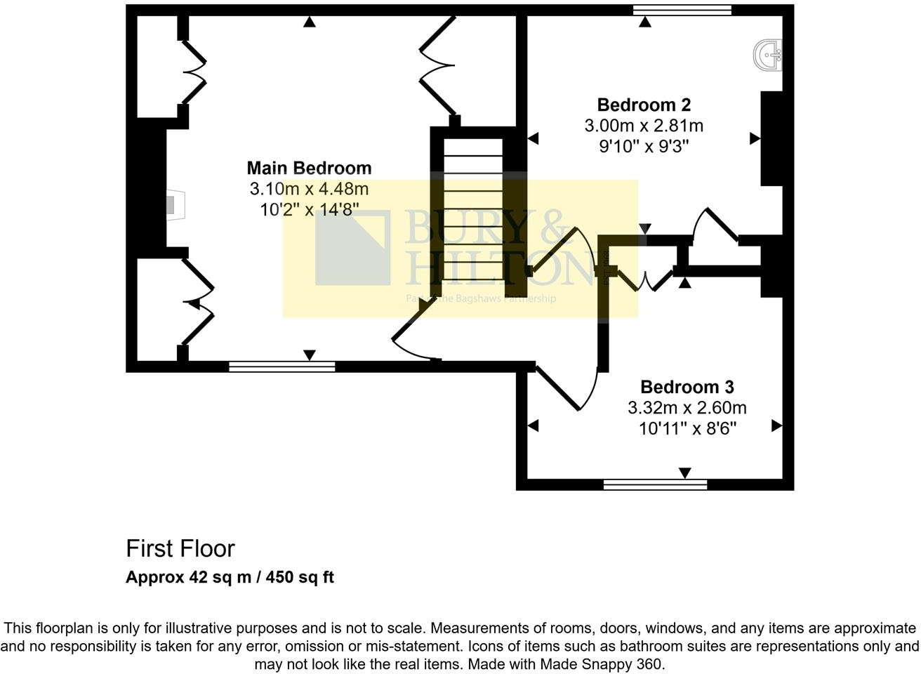
- First floor with three bedrooms.
Rooms
- Bathroom:
- Kitchen:
- Lounge:
- Dining Room:
- Study:
- Main Bedroom:
- Bedroom 2:
- Bedroom 3:
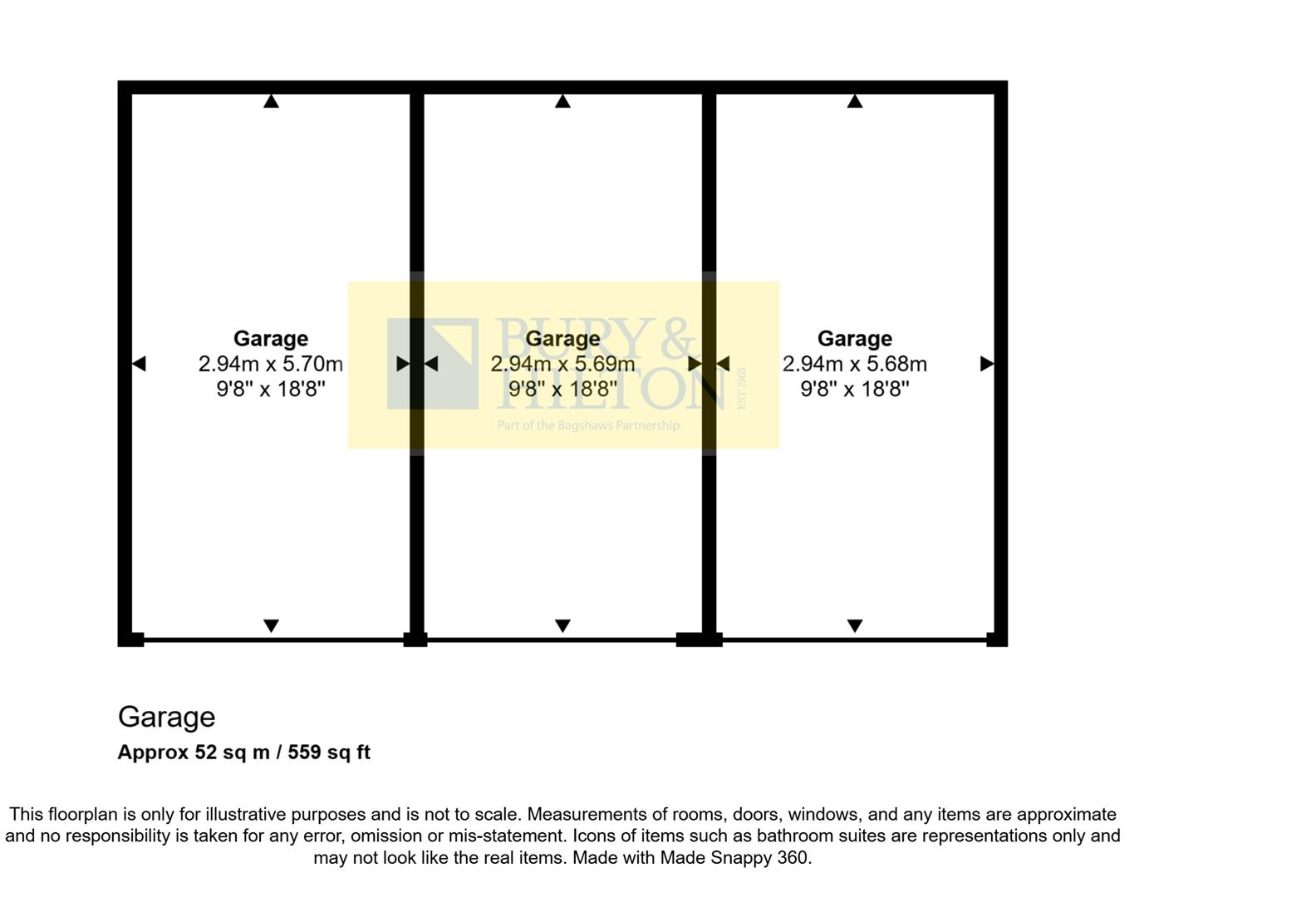
- Garage:
- Garage:
- Garage:
Textual Property Features
- Has Garden
- Chain Free
- Success
Detected Visual Features
- Victorian
- cottage
- brick exterior
- ivy-covered
- historic
- period home
- garden
- country living
- exterior
- traditional
- property
- garage
- trees
- greenery
- outdoor space
- gravel driveway
EPC Details
- Fully double glazed
- Cavity wall, as built, insulated (assumed)
- Boiler and radiators, mains gas
- Low energy lighting in 67% of fixed outlets
- Solid, no insulation (assumed)
Nearby Schools
- Combs Infant School
- Chapel-en-le-Frith High School
- Chapel-en-le-Frith CofE VC Primary School
- Taxal and Fernilee CofE Primary School
- Hollinsclough Church of England Academy
- Buxton Community School
- Buxton Infant School
- Fairfield Infant and Nursery School
- Kettleshulme St James CofE (VA) Primary School
- St Bartholomew's CofE (C) School
- Earl Sterndale CofE Primary School
- Buxton Junior School
- St Thomas More Catholic Voluntary Academy
- Dove Holes CofE Primary School
- Harpur Hill Primary School
- Burbage Primary School
- Fairfield Endowed CofE (C) Junior School
- St Anne's Catholic Voluntary Academy
- Peak Dale Primary School
Nearest General Shops
- Id: 1326954201
- Tags:
- Name: Jack's barbers
- Shop: hairdresser
- TagsNormalized:
- Lat: 53.2562131
- Lon: -1.9151701
- FullGeoHash: gcqwuqvrvm9t
- PartitionGeoHash: gcqw
- Images:
- FoodStandards: null
- Distance: 1242.3
,- Id: 1694044301
- Tags:
- Addr:
- City: Buxton
- Housenumber: 23-27
- Postcode: SK17 6ET
- Street: High Street
- Brand: Bargain Booze
- Brand:wikidata: Q16971315
- Brand:wikipedia: en:Bargain Booze
- Name: Bargain Booze
- Old_fhrs:
- Shop: alcohol
- TagsNormalized:
- Lat: 53.2546164
- Lon: -1.9152536
- FullGeoHash: gcqwuqtqek52
- PartitionGeoHash: gcqw
- Images:
- FoodStandards: null
- Distance: 1210.5
,- Id: 117850924
- Tags:
- Addr:
- City: Buxton
- Housenumber: 42
- Postcode: SK17 6HB
- Street: High Street
- Building: yes
- Name: Scrivener's Books
- Note: Second-hand bookshop, Open Monday-Saturday: 9:30am-5pm Sunday: 12 noon-4pm
- Phone: +44129873100
- Second_hand: only
- Shop: books
- Website: http://www.scrivenersbooks.co.uk
- TagsNormalized:
- Lat: 53.2539114
- Lon: -1.915236
- FullGeoHash: gcqwuqt6eb8e
- PartitionGeoHash: gcqw
- Images:
- FoodStandards: null
- Distance: 1208.1
}
Nearest Grocery shops
- Id: 5112592853
- Tags:
- Brand: Grape Tree
- Brand:wikidata: Q87071497
- Name: Grape Tree
- Shop: health_food
- Source: survey
- Website: https://www.grapetree.co.uk/stores/locator/store/l/buxton/spring-gardens/3423613
- TagsNormalized:
- grape tree
- health
- health food
- food
- shop
- Lat: 53.2596068
- Lon: -1.9120704
- FullGeoHash: gcqwurxetw2c
- PartitionGeoHash: gcqw
- Images:
- FoodStandards: null
- Distance: 1559.7
,- Id: 1325594387
- Tags:
- Addr:
- City: Buxton
- Housenumber: 11
- Postcode: SK17 6EF
- Street: Scarsdale Place
- Brand: McColl's
- Brand:wikidata: Q16997477
- Brand:wikipedia: en:McColl's
- Contact:
- Website: https://www.mccolls.co.uk/storelocator/buxton-11-scarsdale-place/
- Fhrs:
- Name: McColl's
- Shop: convenience
- Toilets:
- Wheelchair: yes
- TagsNormalized:
- Lat: 53.2556013
- Lon: -1.91458
- FullGeoHash: gcqwuqvu759e
- PartitionGeoHash: gcqw
- Images:
- FoodStandards:
- Id: 1258739
- FHRSID: 1258739
- LocalAuthorityBusinessID: 115470
- BusinessName: McColls
- BusinessType: Retailers - other
- BusinessTypeID: 4613
- AddressLine1: 11 Scarsdale Place
- AddressLine2: Buxton
- AddressLine3: Derbyshire
- AddressLine4: null
- PostCode: SK17 6EF
- RatingValue: 5
- RatingKey: fhrs_5_en-GB
- RatingDate: 2019-06-05
- LocalAuthorityCode: 067
- LocalAuthorityName: High Peak
- LocalAuthorityWebSite: http://www.highpeak.gov.uk
- LocalAuthorityEmailAddress: envhealth@highpeak.gov.uk
- Scores:
- Hygiene: 0
- Structural: 0
- ConfidenceInManagement: 0
- NewRatingPending: false
- Geocode:
- Longitude: -1.91444610000000
- Latitude: 53.25557750000000
- Distance: 1268
,- Id: 117846336
- Tags:
- Addr:
- City: Buxton
- Housenumber: 14
- Postcode: SK17 6EQ
- Street: Eagle Parade
- Brand: Sainsbury's Local
- Brand:wikidata: Q13218434
- Brand:wikipedia: en:Sainsbury's Local
- Building: yes
- Name: Sainsbury's Local
- Old_fhrs:
- Shop: convenience
- Wheelchair: yes
- TagsNormalized:
- sainsburys
- sainsburys local
- convenience
- shop
- Lat: 53.2559307
- Lon: -1.9156112
- FullGeoHash: gcqwuqvn710b
- PartitionGeoHash: gcqw
- Images:
- FoodStandards: null
- Distance: 1207.1
}
Nearest Religious buildings
- Id: 117889201
- Tags:
- Amenity: place_of_worship
- Building: yes
- Denomination: anglican
- Name: St Anne
- Religion: christian
- Source: Bing
- Wikidata: Q17546262
- TagsNormalized:
- place of worship
- anglican
- christian
- church
- Lat: 53.2537466
- Lon: -1.9157233
- FullGeoHash: gcqwuqt183vh
- PartitionGeoHash: gcqw
- Images:
- FoodStandards: null
- Distance: 1175.6
,- Id: 117820773
- Tags:
- Addr:
- City: Buxton
- Postcode: SK17 6HX
- Street: Chapel Street
- Amenity: place_of_worship
- Building: yes
- Denomination: methodist
- Fhrs:
- Name: Buxton Methodist Church
- Religion: christian
- Source: OS_OpenData_StreetView;survey
- Website: https://www.buxtonmethodistchurch.org.uk/
- Wheelchair: yes
- TagsNormalized:
- place of worship
- methodist
- church
- christian
- Lat: 53.2554596
- Lon: -1.915965
- FullGeoHash: gcqwuqugdc0y
- PartitionGeoHash: gcqw
- Images:
- FoodStandards:
- Id: 1259034
- FHRSID: 1259034
- LocalAuthorityBusinessID: 2959
- BusinessName: Buxton Methodist Church Luncheon Club
- BusinessType: Restaurant/Cafe/Canteen
- BusinessTypeID: 1
- AddressLine1: Chapel Street
- AddressLine2: Buxton
- AddressLine3: Derbyshire
- AddressLine4: null
- PostCode: SK17 6HX
- RatingValue: 5
- RatingKey: fhrs_5_en-GB
- RatingDate: 2022-03-18
- LocalAuthorityCode: 067
- LocalAuthorityName: High Peak
- LocalAuthorityWebSite: http://www.highpeak.gov.uk
- LocalAuthorityEmailAddress: envhealth@highpeak.gov.uk
- Scores:
- Hygiene: 0
- Structural: 5
- ConfidenceInManagement: 0
- NewRatingPending: false
- Geocode:
- Longitude: -1.91567802429199
- Latitude: 53.25518417358400
- Distance: 1174.5
,- Id: 148061432
- Tags:
- Amenity: place_of_worship
- Building: church
- Denomination: anglican
- Name: Christ Church Burbage
- Religion: christian
- Source: bing
- Wikidata: Q26550324
- TagsNormalized:
- place of worship
- church
- anglican
- christian
- Lat: 53.2529043
- Lon: -1.9358036
- FullGeoHash: gcqwgyqkssb5
- PartitionGeoHash: gcqw
- Images:
- FoodStandards: null
- Distance: 187.2
}
Nearest Medical buildings
- Id: 660617029
- Tags:
- Addr:
- City: Buxton
- Housenumber: 24
- Postcode: SK17 6TE
- Street: Manchester Road
- Amenity: hospital
- Emergency: no
- Fhrs:
- Healthcare: hospital
- Name: Cavendish Hospital
- Toilets:
- Wheelchair: yes
- Wikidata: Q30293222
- TagsNormalized:
- Lat: 53.2623124
- Lon: -1.9207237
- FullGeoHash: gcqxh2177yst
- PartitionGeoHash: gcqx
- Images:
- FoodStandards:
- Id: 1258993
- FHRSID: 1258993
- LocalAuthorityBusinessID: 2080
- BusinessName: Cavendish Hospital (Trust)
- BusinessType: Restaurant/Cafe/Canteen
- BusinessTypeID: 1
- AddressLine1: 24 Manchester Road
- AddressLine2: Buxton
- AddressLine3: Derbyshire
- AddressLine4: null
- PostCode: SK17 6TE
- RatingValue: 5
- RatingKey: fhrs_5_en-GB
- RatingDate: 2022-04-27
- LocalAuthorityCode: 067
- LocalAuthorityName: High Peak
- LocalAuthorityWebSite: http://www.highpeak.gov.uk
- LocalAuthorityEmailAddress: envhealth@highpeak.gov.uk
- Scores:
- Hygiene: 0
- Structural: 0
- ConfidenceInManagement: 0
- NewRatingPending: false
- Geocode:
- Longitude: -1.92125499248505
- Latitude: 53.26244354248050
- Distance: 1269.6
,- Id: 117820774
- Tags:
- Amenity: dentist
- Building: yes
- Healthcare: dentist
- Source: bing
- TagsNormalized:
- Lat: 53.2556032
- Lon: -1.916834
- FullGeoHash: gcqwuquhqebz
- PartitionGeoHash: gcqw
- Images:
- FoodStandards: null
- Distance: 1120.3
,- Id: 117858050
- Tags:
- Amenity: hospital
- Building: yes
- Healthcare: hospital
- Wheelchair: yes
- TagsNormalized:
- Lat: 53.2541476
- Lon: -1.9174624
- FullGeoHash: gcqwuqeezusk
- PartitionGeoHash: gcqw
- Images:
- FoodStandards: null
- Distance: 1060.7
,- Id: 117858033
- Tags:
- Amenity: doctors
- Building: yes
- Healthcare: doctor
- Name: Stewart Medical Centre
- Source: Bing
- Toilets:
- Wheelchair: yes
- TagsNormalized:
- doctor
- doctors
- health
- healthcare
- Lat: 53.253997
- Lon: -1.9180728
- FullGeoHash: gcqwuqe718t3
- PartitionGeoHash: gcqw
- Images:
- FoodStandards: null
- Distance: 1019.6
}
Nearest Airports
- Id: 1224469
- Tags:
- Addr:
- City: Manchester
- Country: GB
- Postcode: M90 1QX
- Aerodrome: international
- Aeroway: aerodrome
- Arp: yes
- Atis: 128.175
- Iata: MAN
- Icao: EGCC
- Name: Manchester Airport
- Note: rough sketched outline referring to Yahoo imagery - true boundary is where?
- Old_name: Ringway
- Operator: Manchester Airport PLC
- Size: 18720000
- Source:
- Tower_frequency: 118.625,119.400
- Type: multipolygon
- Website: https://www.manchesterairport.co.uk/
- Wikidata: Q8694
- Wikipedia: en:Manchester Airport
- TagsNormalized:
- airport
- international airport
- Lat: 53.3503197
- Lon: -2.2798822
- FullGeoHash: gcqrs05u4ukt
- PartitionGeoHash: gcqr
- Images:
- FoodStandards: null
- Distance: 25403.8
}
Nearest Leisure Facilities
- Id: 185123854
- Tags:
- Leisure: garden
- Source: Bing
- TagsNormalized:
- Lat: 53.2575389
- Lon: -1.9213058
- FullGeoHash: gcqwur0zwkfd
- PartitionGeoHash: gcqw
- Images:
- FoodStandards: null
- Distance: 906.6
,- Id: 56130400
- Tags:
- Leisure: park
- Name: Serpentine Park
- Operator: High Peak Borough Council
- TagsNormalized:
- Lat: 53.256868
- Lon: -1.9237781
- FullGeoHash: gcqwupp5sxz0
- PartitionGeoHash: gcqw
- Images:
- FoodStandards: null
- Distance: 726.4
,- Id: 148006188
- Tags:
- Leisure: golf_course
- Name: Cavendish Golf Club
- Source: bing
- TagsNormalized:
- golf
- golf course
- leisure
- club
- Lat: 53.2599537
- Lon: -1.9348702
- FullGeoHash: gcqwgzxjdqbp
- PartitionGeoHash: gcqw
- Images:
- FoodStandards: null
- Distance: 694.1
,- Id: 1009707883
- Tags:
- TagsNormalized:
- outdoor
- outdoor seating
- leisure
- Lat: 53.2500338
- Lon: -1.9260398
- FullGeoHash: gcqwujvebjb8
- PartitionGeoHash: gcqw
- Images:
- FoodStandards: null
- Distance: 642.2
,- Id: 148059356
- Tags:
- Leisure: pitch
- Name: Burbage Crown Green Bowls Club
- Source: survey and bing
- Sport: bowls
- TagsNormalized:
- pitch
- leisure
- bowls
- club
- sports
- Lat: 53.2537886
- Lon: -1.9355791
- FullGeoHash: gcqwgyw9c9xw
- PartitionGeoHash: gcqw
- Images:
- FoodStandards: null
- Distance: 145.3
}
Nearest Tourist attractions
- Id: 740505907
- Tags:
- Name: Buxton Caravan and Motorhome Club
- Tourism: caravan_site
- TagsNormalized:
- Lat: 53.2460244
- Lon: -1.9294152
- FullGeoHash: gcqwuj5h967g
- PartitionGeoHash: gcqw
- Images:
- FoodStandards: null
- Distance: 901.5
,- Id: 740509862
- Tags:
- Name: 72
- Ref: 72
- Tourism: camp_pitch
- TagsNormalized:
- Lat: 53.2462539
- Lon: -1.9305118
- FullGeoHash: gcqwuj4jzv4h
- PartitionGeoHash: gcqw
- Images:
- FoodStandards: null
- Distance: 857.9
,- Id: 361061810
- Tags:
- Name: Poole's Cavern
- Natural: cave_entrance
- Toilets:
- Tourism: attraction
- Wheelchair: limited
- Wikidata: Q15267449
- TagsNormalized:
- Lat: 53.2501141
- Lon: -1.9263169
- FullGeoHash: gcqwujvk3sdp
- PartitionGeoHash: gcqw
- Images:
- FoodStandards: null
- Distance: 622.4
}
Nearest Train stations
- Id: 7154317764
- Tags:
- Addr:
- Postcode: SK23 7AA
- Street: Market Street
- Name: Whaley Bridge
- Naptan:
- Network: National Rail
- Public_transport: station
- Railway: station
- Ref:
- Start_date: 1857
- Train: yes
- Wikidata: Q2111822
- Wikipedia: en:Whaley Bridge railway station
- TagsNormalized:
- Lat: 53.3302649
- Lon: -1.9847378
- FullGeoHash: gcqx6u6z23bj
- PartitionGeoHash: gcqx
- Images:
- FoodStandards: null
- Distance: 9164.5
,- Id: 6439021768
- Tags:
- Name: Chapel-en-le-Frith
- Naptan:
- Network: National Rail
- Public_transport: station
- Railway: station
- Ref:
- Wikidata: Q1839026
- Wikipedia: en:Chapel-en-le-Frith railway station
- TagsNormalized:
- Lat: 53.3120572
- Lon: -1.9183726
- FullGeoHash: gcqxk35j4xv8
- PartitionGeoHash: gcqx
- Images:
- FoodStandards: null
- Distance: 6557.3
,- Id: 6439021769
- Tags:
- Name: Dove Holes
- Naptan:
- Network: National Rail
- Public_transport: station
- Railway: station
- Ref:
- Wikidata: Q2280131
- Wikipedia: en:Dove Holes railway station
- TagsNormalized:
- Lat: 53.3001375
- Lon: -1.8897118
- FullGeoHash: gcqxhyzzy9bb
- PartitionGeoHash: gcqx
- Images:
- FoodStandards: null
- Distance: 5917.2
,- Id: 5060042354
- Tags:
- Name: Buxton
- Naptan:
- Network: National Rail
- Operator: Northern
- Public_transport: station
- Railway: station
- Ref:
- Wheelchair: yes
- Wikidata: Q2932479
- Wikipedia: en:Buxton railway station
- TagsNormalized:
- Lat: 53.2607853
- Lon: -1.9131016
- FullGeoHash: gcqwuryft9bp
- PartitionGeoHash: gcqw
- Images:
- FoodStandards: null
- Distance: 1558.8
,- Id: 1127746349
- Tags:
- Name: Buxton Miniature Railway
- Public_transport: station
- Railway: station
- Usage: tourism
- TagsNormalized:
- Lat: 53.2566395
- Lon: -1.9185882
- FullGeoHash: gcqwur4fmthv
- PartitionGeoHash: gcqw
- Images:
- FoodStandards: null
- Distance: 1035.2
}
Nearest Bus stations and stops
- Id: 9193801869
- Tags:
- Bus: yes
- Highway: bus_stop
- Name: Buxton, Terrace Road / Market Place (Stop A)
- Network: Derbyshire County Council
- Operator: Derbyshire County Council
- Public_transport: platform
- Ref: A
- TagsNormalized:
- Lat: 53.2563879
- Lon: -1.9141585
- FullGeoHash: gcqwurn0uy7b
- PartitionGeoHash: gcqw
- Images:
- FoodStandards: null
- Distance: 1312.2
,- Id: 9193801868
- Tags:
- Bus: yes
- Highway: bus_stop
- Name: Buxton, Terrace Road / Market Place (Stop B)
- Network: Derbyshire County Council
- Operator: Derbyshire County Council
- Public_transport: platform
- Ref: B
- TagsNormalized:
- Lat: 53.2562489
- Lon: -1.9143663
- FullGeoHash: gcqwurn00h35
- PartitionGeoHash: gcqw
- Images:
- FoodStandards: null
- Distance: 1295.4
,- Id: 9178203522
- Tags:
- Bench: yes
- Bin: no
- Bus: yes
- Highway: bus_stop
- Lit: no
- Name: Buxton, Terrace Road / Market Place (Stop E)
- Network: Derbyshire County Council
- Operator: Derbyshire County Council
- Public_transport: platform
- Ref: E
- Shelter: yes
- Tactile_paving: no
- TagsNormalized:
- Lat: 53.2560106
- Lon: -1.9143543
- FullGeoHash: gcqwuqyn8rcv
- PartitionGeoHash: gcqw
- Images:
- FoodStandards: null
- Distance: 1290.8
,- Id: 9193801866
- Tags:
- Bus: yes
- Highway: bus_stop
- Name: Buxton, Terrace Road / Market Place (Stop D)
- Network: Derbyshire County Council
- Operator: Derbyshire County Council
- Public_transport: platform
- Ref: D
- TagsNormalized:
- Lat: 53.2559346
- Lon: -1.914448
- FullGeoHash: gcqwuqvyq1u0
- PartitionGeoHash: gcqw
- Images:
- FoodStandards: null
- Distance: 1283.1
,- Id: 9193801867
- Tags:
- Bus: yes
- Highway: bus_stop
- Name: Buxton, Terrace Road / Market Place (Stop C)
- Network: Derbyshire County Council
- Operator: Derbyshire County Council
- Public_transport: platform
- Ref: C
- TagsNormalized:
- Lat: 53.2561176
- Lon: -1.9145344
- FullGeoHash: gcqwuqvzk5ge
- PartitionGeoHash: gcqw
- Images:
- FoodStandards: null
- Distance: 1281.4
}
Nearest Hotels
- Id: 794573910
- Tags:
- Addr:
- City: Buxton
- Housenumber: 32
- Postcode: SK17 6XQ
- Street: St John's Road
- Fhrs:
- Name: Portland Hotel
- Tourism: hotel
- TagsNormalized:
- Lat: 53.2579283
- Lon: -1.9210101
- FullGeoHash: gcqwur31vjrj
- PartitionGeoHash: gcqw
- Images:
- FoodStandards: null
- Distance: 944.5
,- Id: 185078125
- Tags:
- Source: Bing
- Tourism: hotel
- TagsNormalized:
- Lat: 53.2574657
- Lon: -1.9216301
- FullGeoHash: gcqwur0xnz0t
- PartitionGeoHash: gcqw
- Images:
- FoodStandards: null
- Distance: 883.7
,- Id: 97199030
- Tags:
- Addr:
- City: Buxton
- Housenumber: 1-2
- Postcode: SK17 9AS
- Street: Burlington Road
- Building: hotel
- Name: Buckingham Hotel
- Old_fhrs:
- Source: Bing
- Tourism: hotel
- TagsNormalized:
- Lat: 53.2574569
- Lon: -1.9216724
- FullGeoHash: gcqwur0xjv91
- PartitionGeoHash: gcqw
- Images:
- FoodStandards: null
- Distance: 880.8
}
Tags
- Victorian
- cottage
- brick exterior
- ivy-covered
- historic
- period home
- garden
- country living
- exterior
- traditional
- property
- garage
- garden
- trees
- greenery
- outdoor space
- gravel driveway
Local Market Stats
- Average Price/sqft: £248
- Avg Income: £40300
- Rental Yield: 3.5%
- Social Housing: 6%
- Planning Success Rate: 81%
AirBnB Data
- 1km average: £107/night
- Listings in 1km: 1
Similar Properties
 6 bedroom character property for sale in Macclesfield Road, Buxton, SK17 — £695,000 • 6 bed • 2 bath • 1754 ft²
 Semi-detached house for sale in Sherbrook Grove, Buxton, SK17 — £410,000 • 1 bed • 1 bath • 1066 ft²
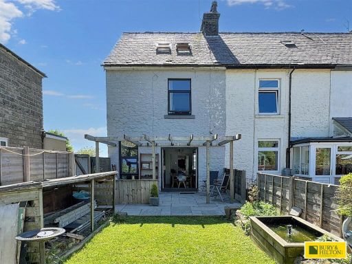 3 bedroom end of terrace house for sale in New Cottages, Grinlow Road, Buxton, SK17 — £279,000 • 3 bed • 3 bath • 1270 ft²
 3 bedroom semi-detached house for sale in Tedder Avenue, Buxton, SK17 — £265,000 • 3 bed • 1 bath • 1193 ft²
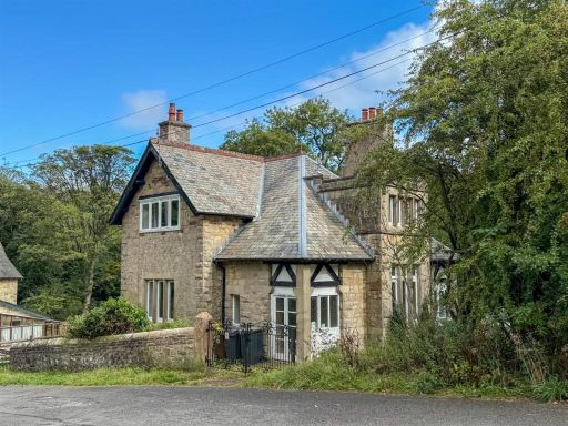 3 bedroom detached house for sale in Buxton, Derbyshire, SK17 — £600,000 • 3 bed • 1 bath • 1389 ft²
 4 bedroom end of terrace house for sale in Leek Road, BUXTON, Derbyshire, SK17 — £310,000 • 4 bed • 1 bath • 1223 ft²
Meta
- {
"@context": "https://schema.org",
"@type": "Residence",
"name": "3 bedroom semidetached house for sale in Macclesfield Road,…",
"description": "",
"url": "https://propertypiper.co.uk/property/11571340-0c85-47db-a895-6c400cfaeba6",
"image": "https://image-a.propertypiper.co.uk/50ae91bb-d9a3-4dc6-bfc8-7ebc9707475d-1024.jpeg",
"address": {
"@type": "PostalAddress",
"streetAddress": "112, MACCLESFIELD ROAD, BUXTON",
"postalCode": "SK17 9AD",
"addressLocality": "High Peak",
"addressRegion": "High Peak",
"addressCountry": "England"
},
"geo": {
"@type": "GeoCoordinates",
"latitude": 53.253774,
"longitude": -1.9333948
},
"numberOfRooms": 3,
"numberOfBathroomsTotal": 1,
"floorSize": {
"@type": "QuantitativeValue",
"value": 464,
"unitCode": "FTK"
},
"offers": {
"@type": "Offer",
"price": 350000,
"priceCurrency": "GBP",
"availability": "https://schema.org/InStock"
},
"additionalProperty": [
{
"@type": "PropertyValue",
"name": "Feature",
"value": "Victorian"
},
{
"@type": "PropertyValue",
"name": "Feature",
"value": "cottage"
},
{
"@type": "PropertyValue",
"name": "Feature",
"value": "brick exterior"
},
{
"@type": "PropertyValue",
"name": "Feature",
"value": "ivy-covered"
},
{
"@type": "PropertyValue",
"name": "Feature",
"value": "historic"
},
{
"@type": "PropertyValue",
"name": "Feature",
"value": "period home"
},
{
"@type": "PropertyValue",
"name": "Feature",
"value": "garden"
},
{
"@type": "PropertyValue",
"name": "Feature",
"value": "country living"
},
{
"@type": "PropertyValue",
"name": "Feature",
"value": "exterior"
},
{
"@type": "PropertyValue",
"name": "Feature",
"value": "traditional"
},
{
"@type": "PropertyValue",
"name": "Feature",
"value": "property"
},
{
"@type": "PropertyValue",
"name": "Feature",
"value": "garage"
},
{
"@type": "PropertyValue",
"name": "Feature",
"value": "garden"
},
{
"@type": "PropertyValue",
"name": "Feature",
"value": "trees"
},
{
"@type": "PropertyValue",
"name": "Feature",
"value": "greenery"
},
{
"@type": "PropertyValue",
"name": "Feature",
"value": "outdoor space"
},
{
"@type": "PropertyValue",
"name": "Feature",
"value": "gravel driveway"
}
]
}
High Res Floorplan Images
Compatible Floorplan Images
FloorplanImages Thumbnail