WS7 9BY - 3 bedroom detached house for sale in Highfield Road, Burntw…
View on Property Piper
3 bedroom detached house for sale in Highfield Road, Burntwood, WS7
Property Details
- Price: £350000
- Bedrooms: 3
- Bathrooms: 1
- Property Type: undefined
- Property SubType: undefined
Brochure Descriptions
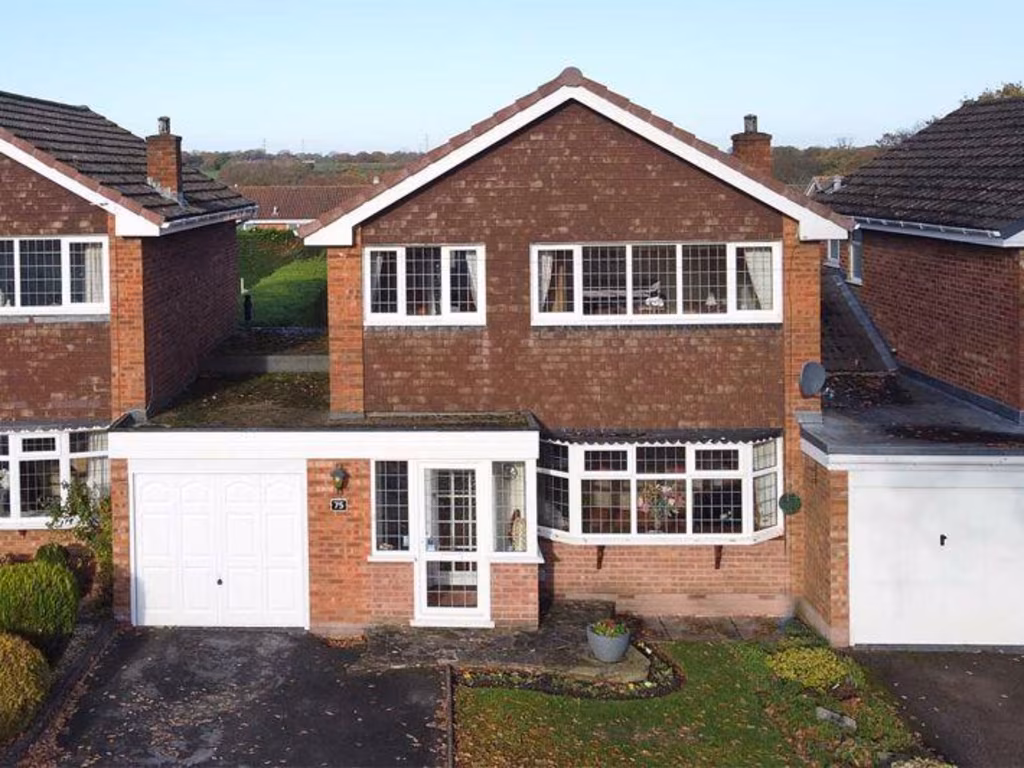
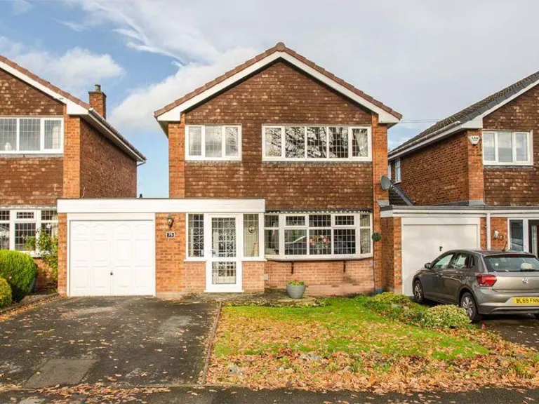
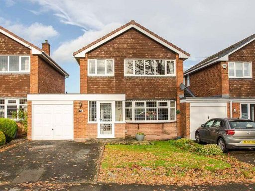
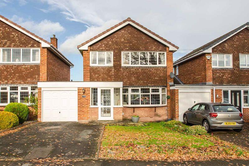
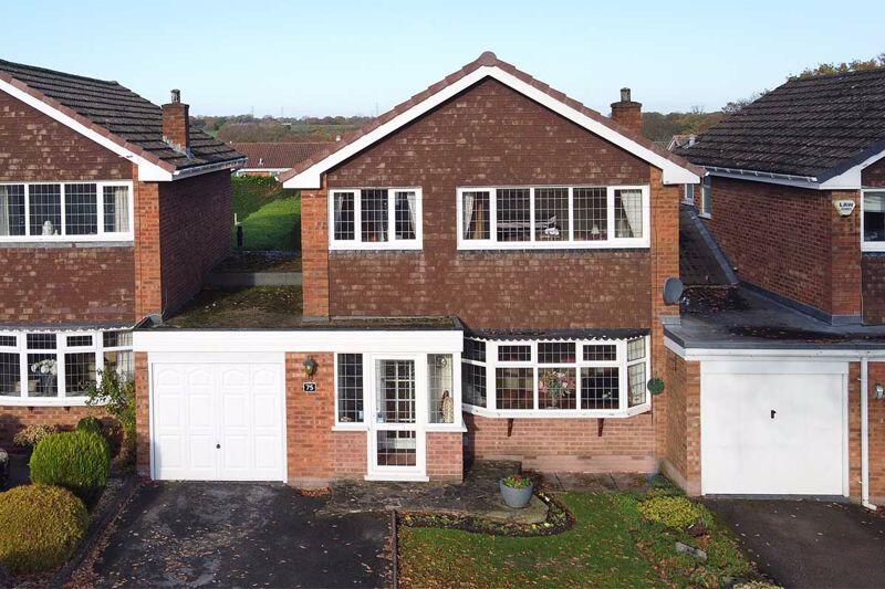
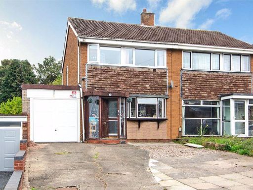
- Detached two-storey family home on a suburban road. Brick and tile-clad façade with an attached single garage and paved driveway providing off-street parking for two vehicles. Ground floor includes a porch/entrance, bay-fronted living room and likely separate dining/kitchen arrangement; first floor presents a conventional layout of bedrooms and bathroom(s). Small to average front garden with lawn and planting; rear garden not visible but typical for this style would be medium depth. Overall property size appears to be a mid-sized family house (three to four bedroom equivalent). Setting: residential street with neighbouring detached houses, no notable long-distance views — typical suburban environment.
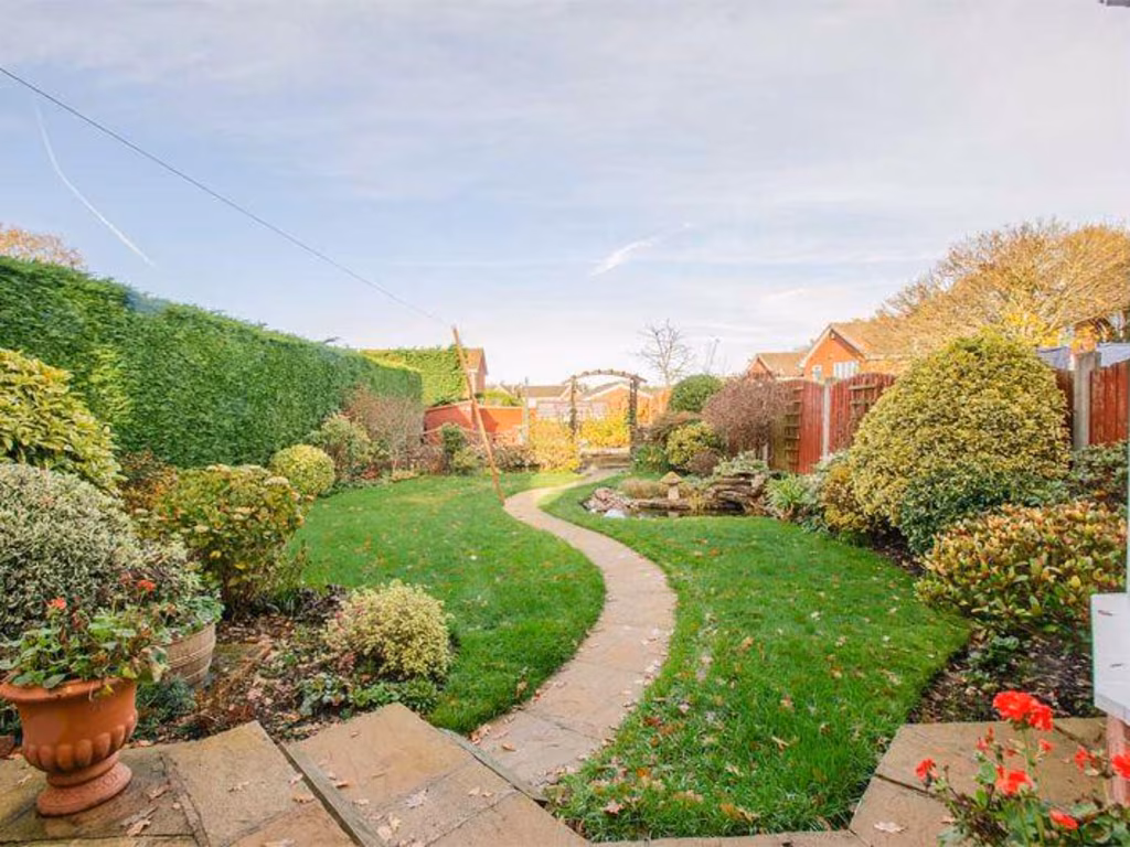
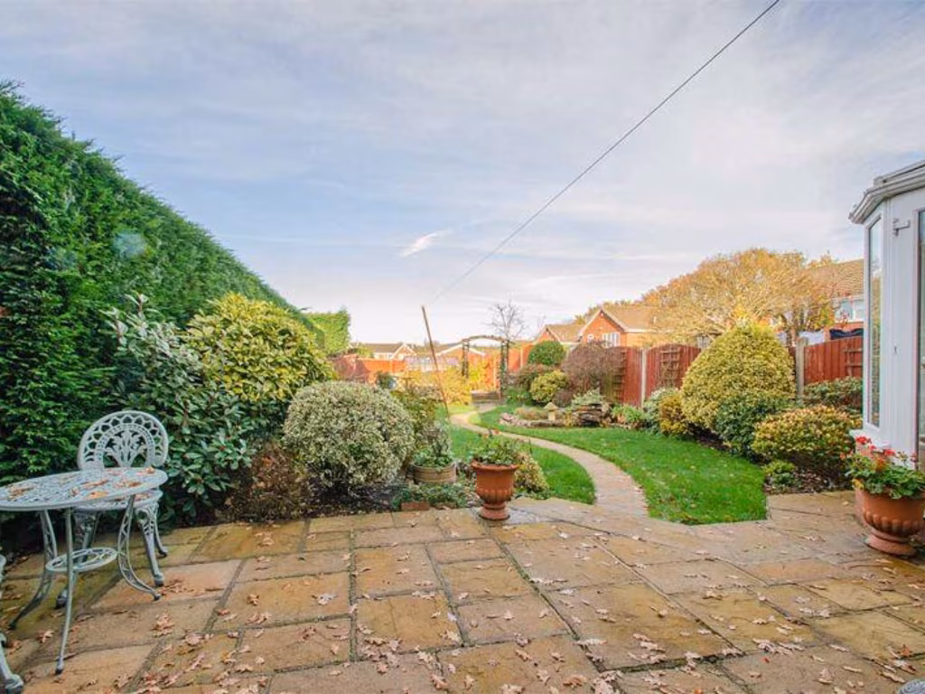
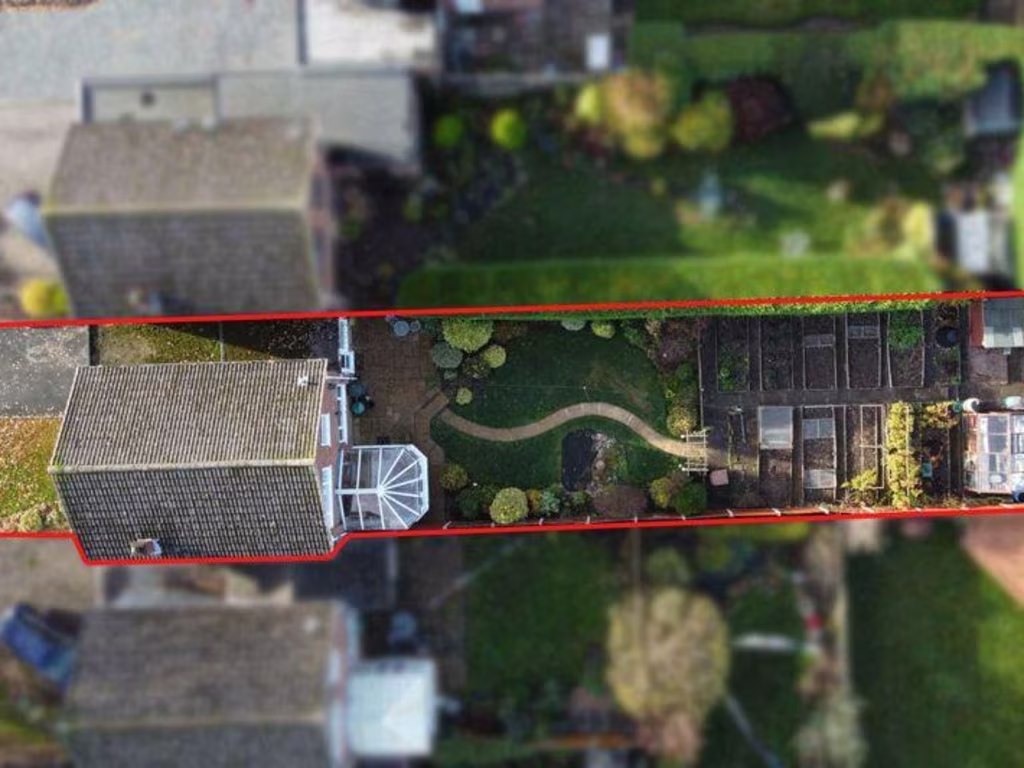
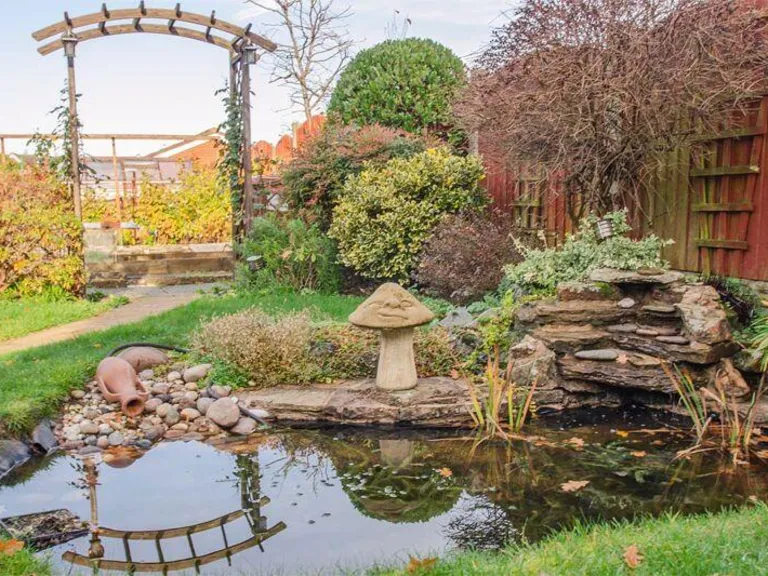
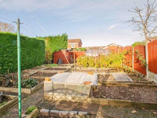
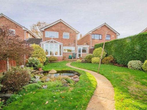
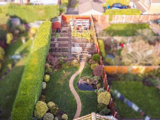
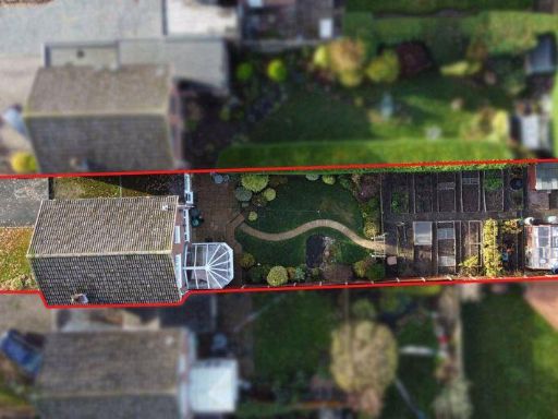
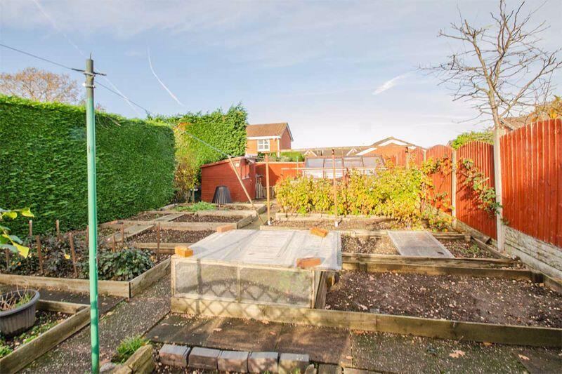
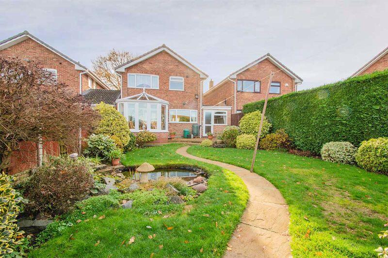
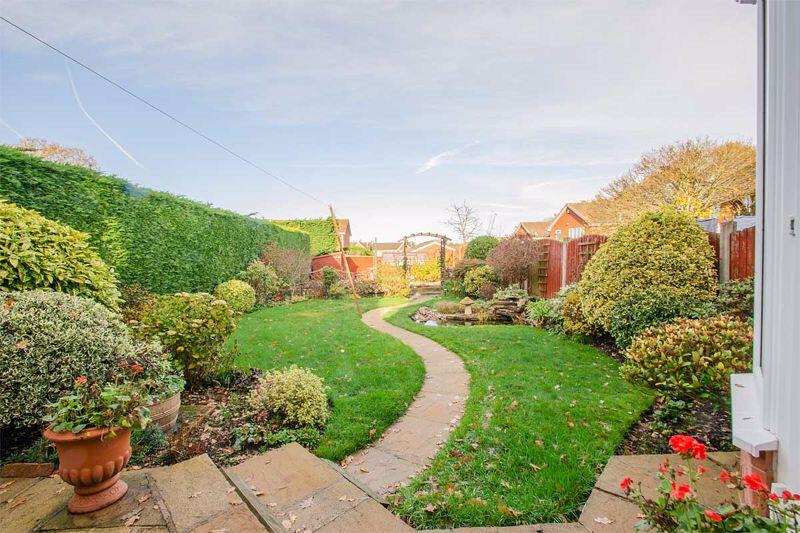
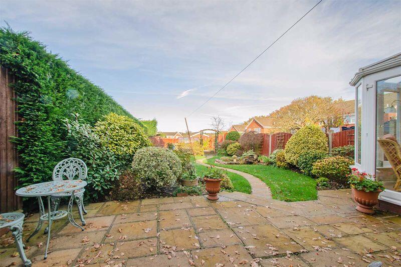
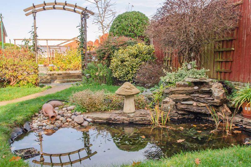
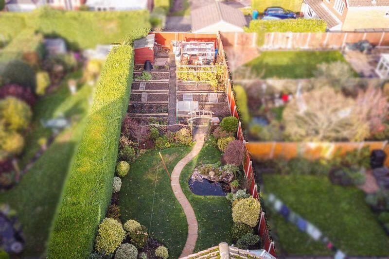
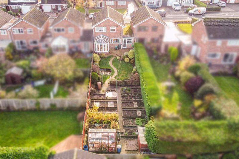
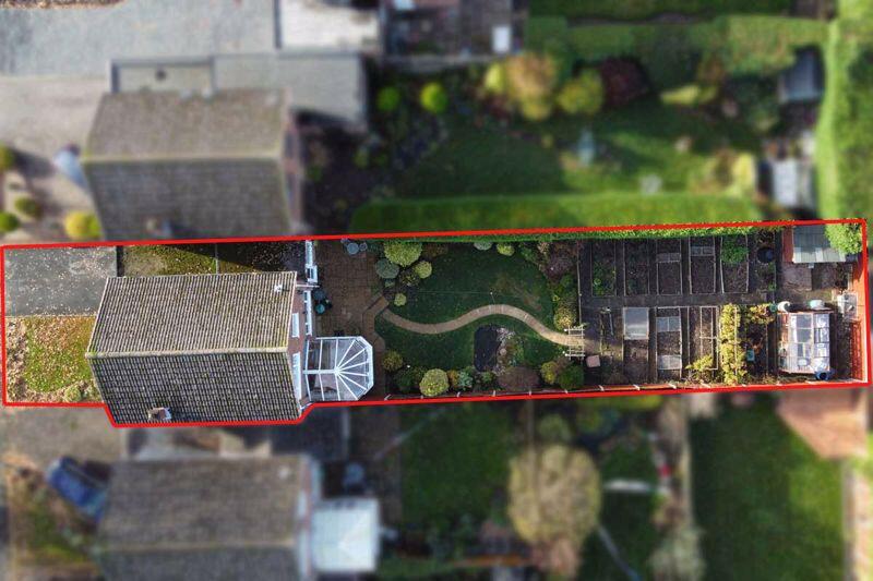
- Photographs show a well-maintained suburban rear garden associated with a residential dwelling. The garden is of above-average depth for a typical suburban plot (large rear garden), with a paved patio/steps at the house, a gently curving central paved path leading through an expanse of lawn, mature perimeter hedging and timber fencing providing good privacy, and a formal planted border with a variety of shrubs. A water feature/ornamental pond and stone waterfall are present toward the middle/rear of the plot, enhancing visual amenity. Small ornamental planters and well-kept beds indicate regular upkeep. Elevated views toward neighbouring houses suggest this is a rear garden in a built-up residential area (no notable open countryside, sea or river views). Overall impression for a valuator: attractive private outdoor space with mature landscaping and a sizeable lawn area that will add strong amenity value to the dwelling; suitable for family use and likely to appeal to buyers seeking private, low-maintenance mature gardens. No internal rooms, exact plot area or floorplan information visible, so total property size cannot be determined from the images provided.
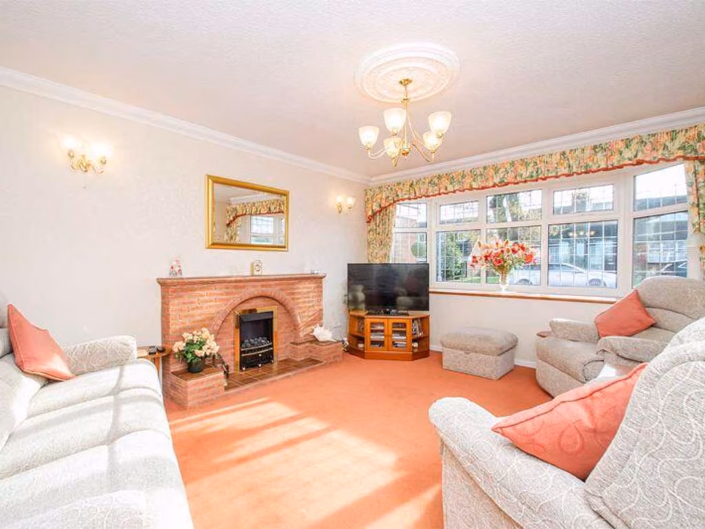
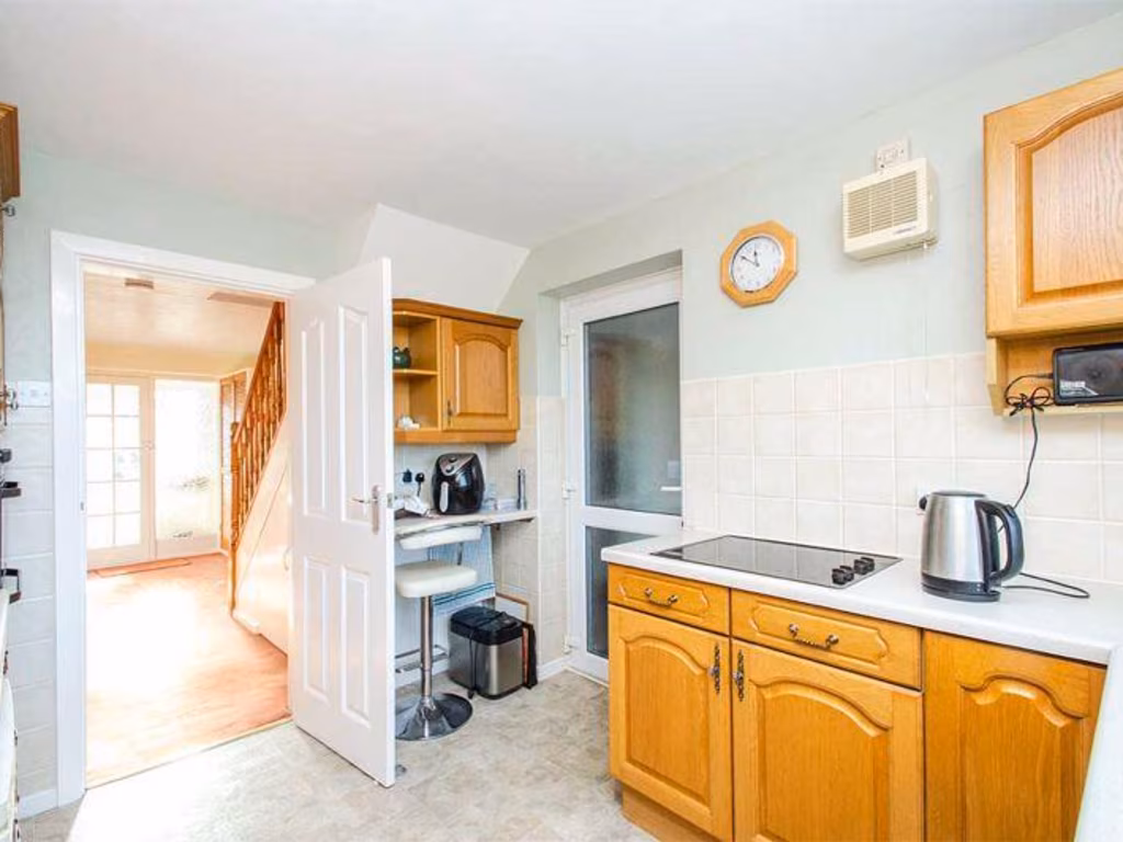
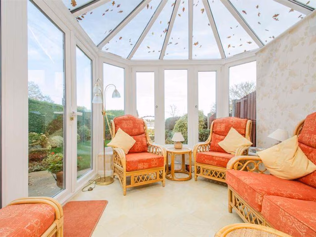
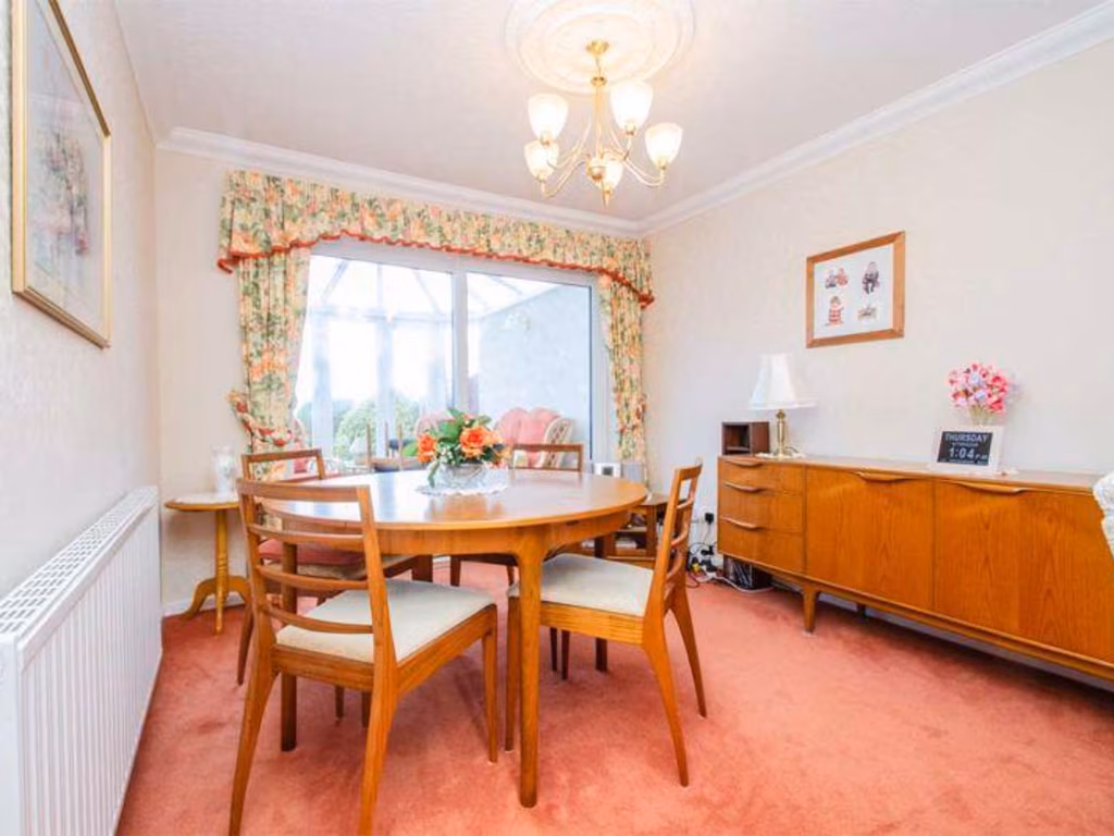
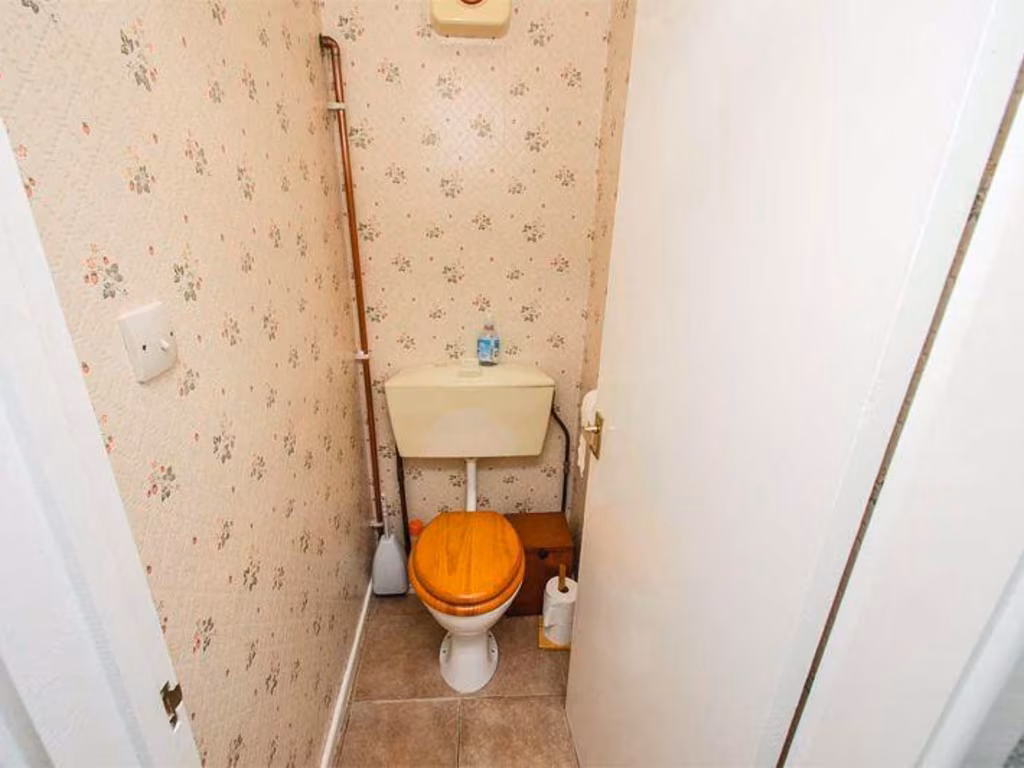
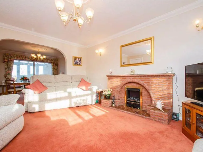
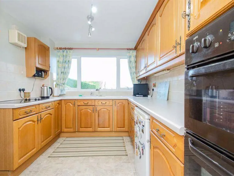
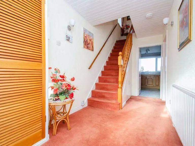
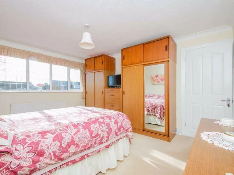
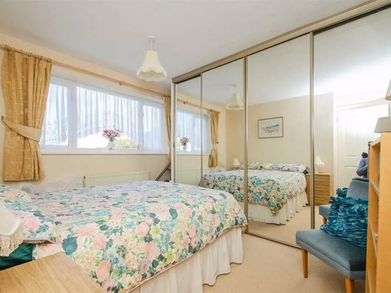
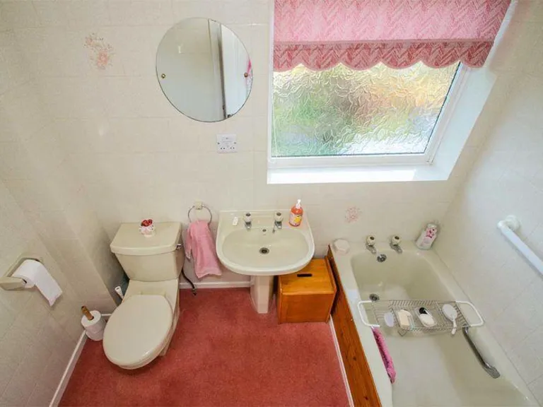
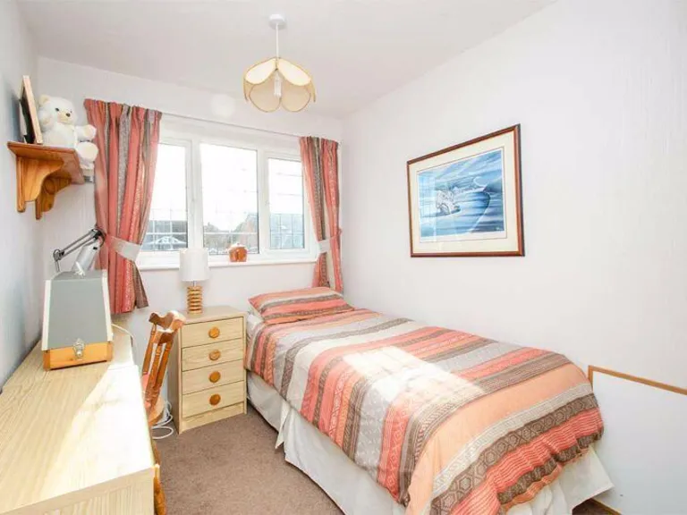
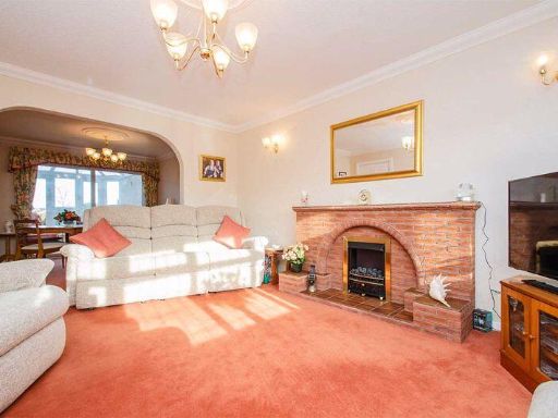
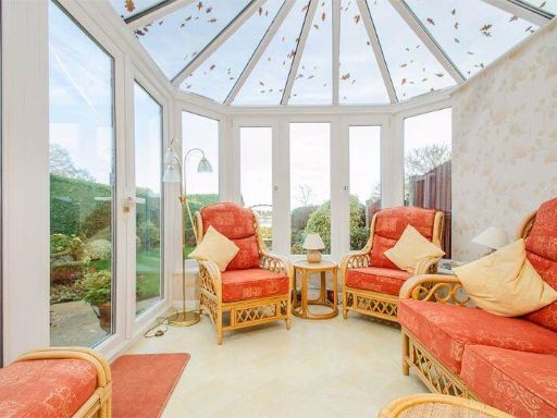
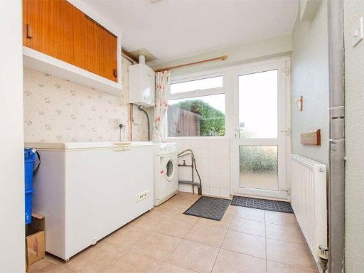
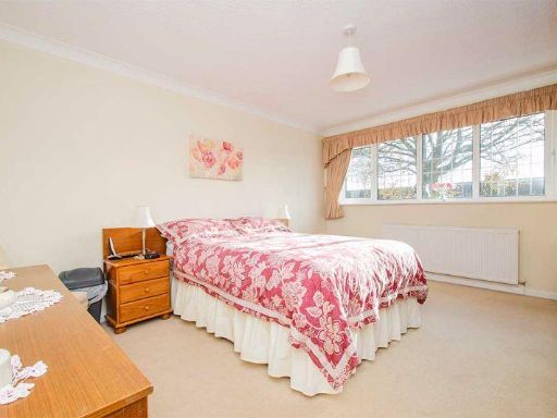
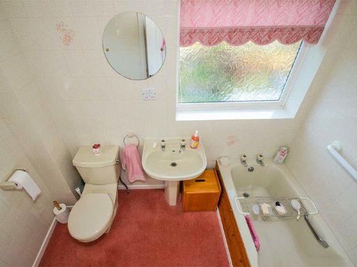
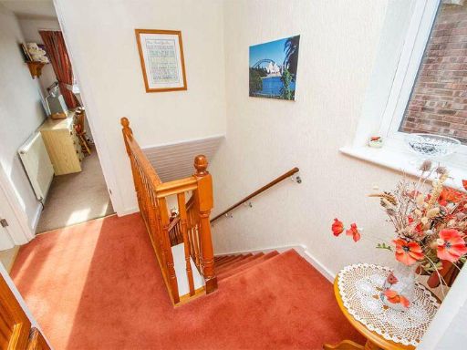
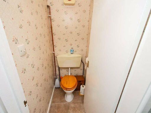
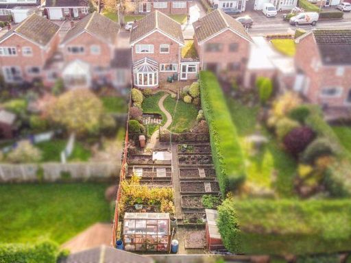
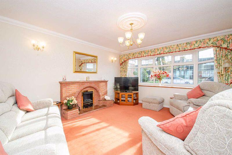
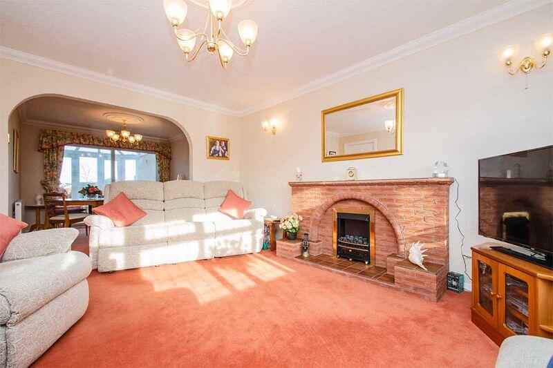
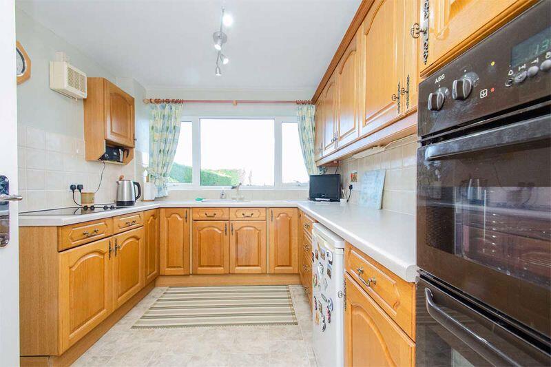
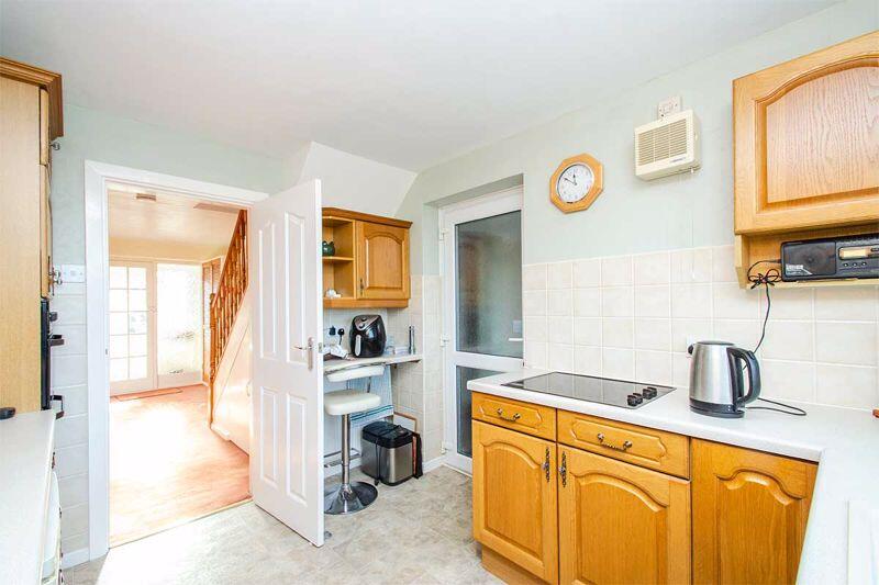
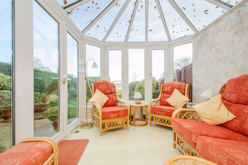
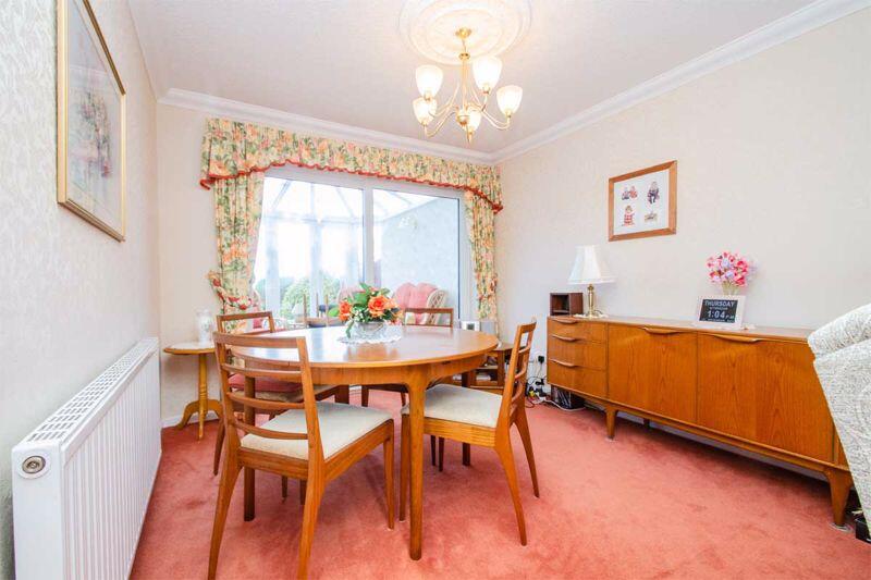
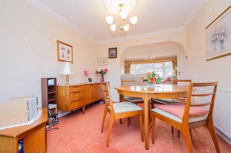
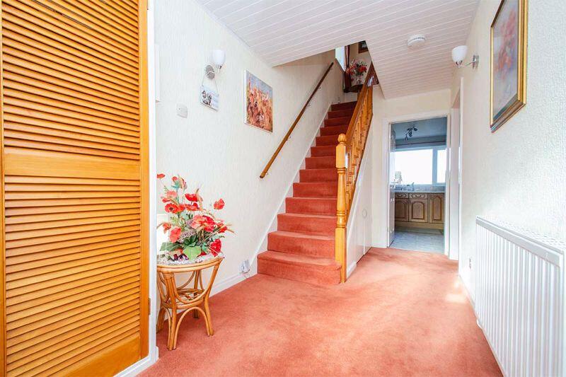
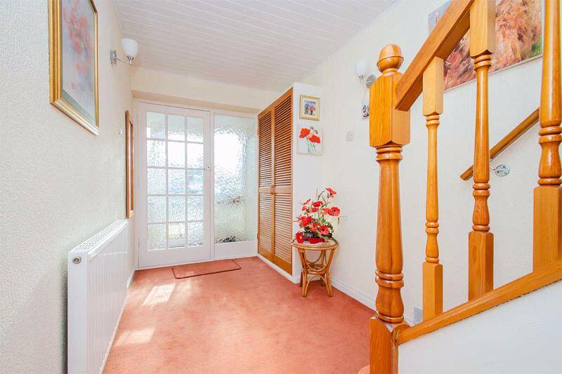
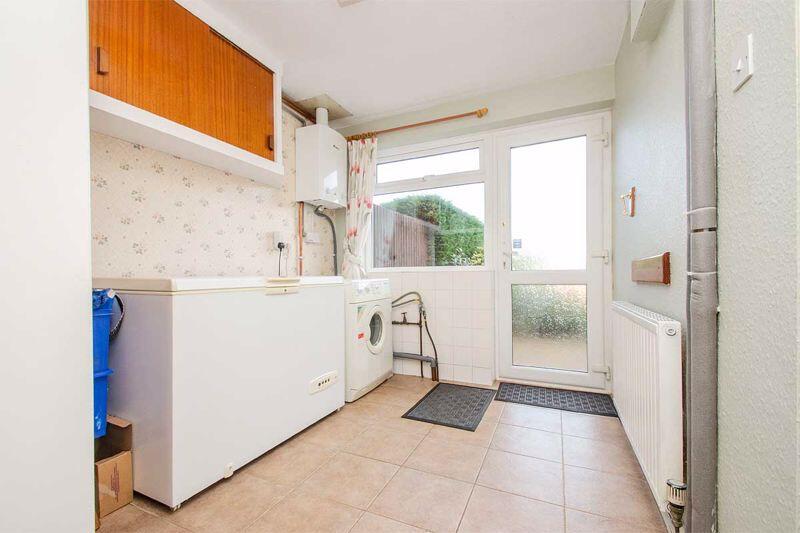
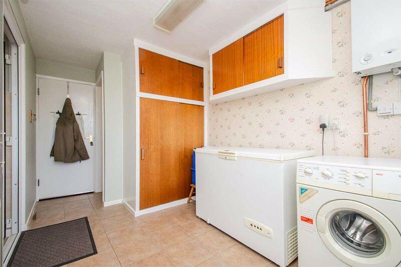
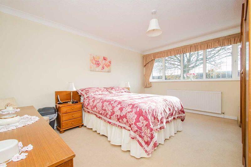
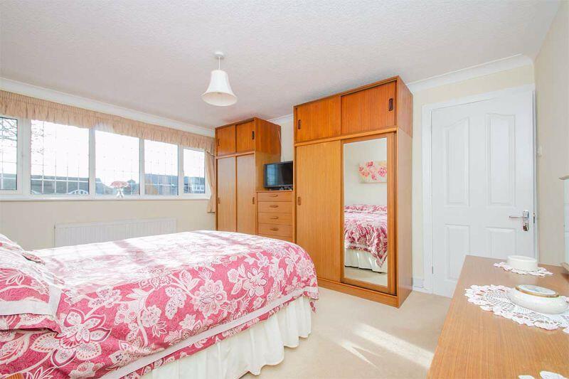
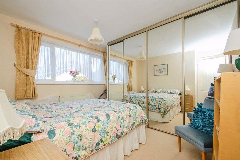
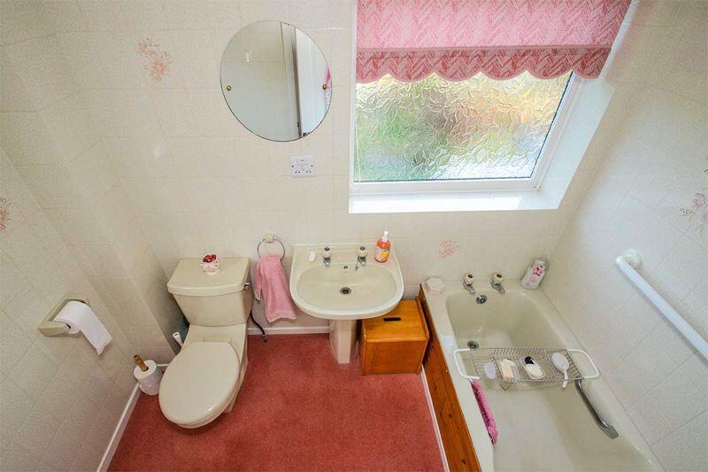
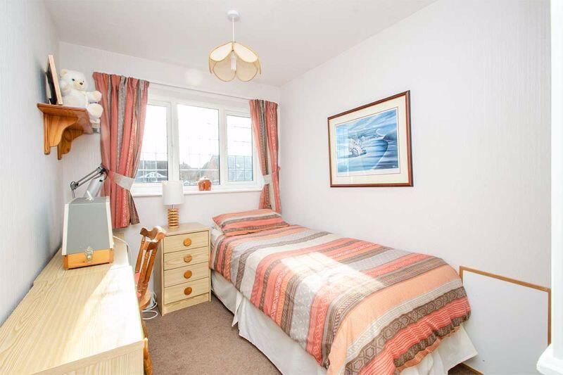
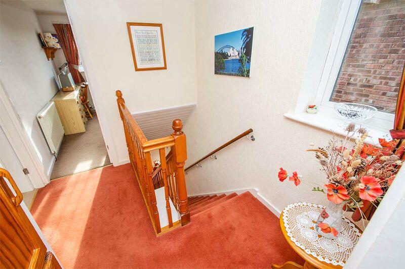
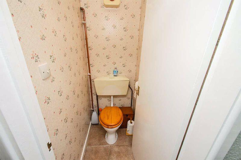
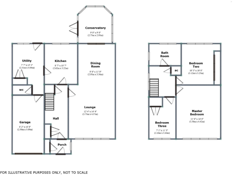
- Three-bedroom detached family home on Highfield Road, Burntwood. The property appears to sit on a large plot with a two-car driveway to the front and a substantial rear garden, including a patio and a large rear lawn. Internally the accommodation is well-proportioned and light with a traditional layout: reception hall, lounge with feature fireplace and large bay window, separate dining area leading to a conservatory, fitted kitchen with adjoining utility, ground-floor WC, integral/attached garage and first-floor landing leading to three bedrooms and a family bathroom. The conservatory provides good additional living space and views over the garden. Construction and finishes appear traditional and well maintained (UPVC double glazing, gas central heating). Overall impression (valuator’s view): a mid-sized detached family property in good decorative order on a generous plot offering strong potential for family occupation or modest improvement to increase value, with a large garden being a key asset. Room sizes and garden are above average for the area; overall property footprint is moderate/average for a three-bedroom detached home.
Image Descriptions
- detached house 1970s suburban
- living room mid-20th century traditional
Floorplan Description
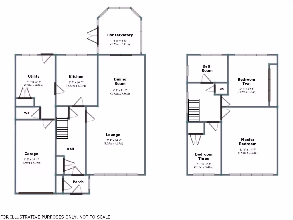
- Two-storey house plan with lounge, dining room, kitchen, utility and conservatory on ground floor; three bedrooms and bathroom on first floor.
Rooms
- Conservatory:
- Utility:
- Kitchen:
- Dining Room:
- Lounge:
- Garage:
- Bedroom Two:
- Bedroom Three:
- Master Bedroom:
Textual Property Features
- Has Garden
- Chain Free
- Success
Detected Visual Features
- detached house
- 1970s
- suburban
- garage
- garden
- brick exterior
- two-story
- driveway
- residential
- family home
- living room
- mid-20th century
- traditional style
- brick fireplace
- large window
- ceiling molding
- traditional lighting
- retro decor
Nearby Schools
- St John's Church of England Primary School
- St Peter's Church of England Primary Academy
- Holy Trinity Church of England Primary School
- Ridgeway Primary Academy
- St Joseph and St Theresa Catholic Primary
- Norton Canes Primary Academy
- Highfields Primary Academy
- Chase Terrace Academy
- St James Primary School
- Brownhills Ormiston Academy
- Gentleshaw Primary Academy
- St Bernadette's Catholic Primary School
- Watling Street Primary School
- Fulfen Primary School
- Chase Terrace Primary School
- Boney Hay Primary Academy
- Castlefort Junior Mixed and Infant School
- Shire Oak Academy
- Millfield Primary School
- Brownhills West Primary School
- Erasmus Darwin Academy
- Springhill Primary Academy
- Norton Canes High School
- Holly Grove Primary Academy
- St James Church of England Primary Academy
Nearest Bars And Restaurants
- Id: 8650917485
- Tags:
- Addr:
- City: Burntwood
- Postcode: WS7 2ER
- Street: Ryecroft Shopping Centre, 3 Parkhill Rd
- Amenity: restaurant
- Cuisine: indian
- Name: King of Spice
- Website: https://kingspice.co.uk/
- TagsNormalized:
- Lat: 52.6857162
- Lon: -1.9259242
- FullGeoHash: gcqespjsd9qf
- PartitionGeoHash: gcqe
- Images:
- FoodStandards: null
- Distance: 991.3
,- Id: 131615737
- Tags:
- Amenity: pub
- Building: yes
- Name: The Drill Inn
- Source: visual survey; bing
- TagsNormalized:
- Lat: 52.6890728
- Lon: -1.9110908
- FullGeoHash: gcqesxb2h753
- PartitionGeoHash: gcqe
- Images:
- FoodStandards: null
- Distance: 687.9
,- Id: 842470390
- Tags:
- Amenity: fast_food
- Building: yes
- Cuisine: chinese
- Name: Mayflower
- TagsNormalized:
- Lat: 52.677728
- Lon: -1.9077412
- FullGeoHash: gcqestdy42jp
- PartitionGeoHash: gcqe
- Images:
- FoodStandards: null
- Distance: 642.7
,- Id: 368233139
- Tags:
- Amenity: pub
- Name: White Swan
- TagsNormalized:
- Lat: 52.6783591
- Lon: -1.9074332
- FullGeoHash: gcqestg19tfs
- PartitionGeoHash: gcqe
- Images:
- FoodStandards: null
- Distance: 591
,- Id: 259571340
- Tags:
- Amenity: pub
- Created_by: JOSM
- Name: The Nags Head
- TagsNormalized:
- Lat: 52.6859682
- Lon: -1.9057287
- FullGeoHash: gcqesxhq123d
- PartitionGeoHash: gcqe
- Images:
- FoodStandards: null
- Distance: 540.8
}
Nearest General Shops
- Id: 1299486096
- Tags:
- Name: Chasewater Cycle
- Shop: bicycle
- TagsNormalized:
- Lat: 52.6615356
- Lon: -1.94247
- FullGeoHash: gcqeef9x9jv2
- PartitionGeoHash: gcqe
- Images:
- FoodStandards: null
- Distance: 3143
,- Id: 368200664
- Tags:
- Brand: Ford
- Brand:wikidata: Q44294
- Brand:wikipedia: en:Ford Motor Company
- Name: Acorn Ford
- Operator: Ford
- Shop: car_repair
- TagsNormalized:
- Lat: 52.681973
- Lon: -1.93869
- FullGeoHash: gcqeeykq9pxc
- PartitionGeoHash: gcqe
- Images:
- FoodStandards: null
- Distance: 1804.5
,- Id: 507198724
- Tags:
- Addr:
- City: Burntwood
- Housenumber: 14
- Postcode: WS7 9AP
- Street: Deerfold Crescent
- Building: yes
- Drive_through: yes
- Name: Scotts Bargain Bananza
- Opening_hours: sunrise-sunset
- Operator: Scotty Boy Himself!
- Shop: alcohol
- Source: Bing;Google;Yahoo;Mark Next Door
- TagsNormalized:
- Lat: 52.6815911
- Lon: -1.9184299
- FullGeoHash: gcqesq7h926g
- PartitionGeoHash: gcqe
- Images:
- FoodStandards: null
- Distance: 459.7
}
Nearest Grocery shops
- Id: 357824328
- Tags:
- Addr:
- City: Burntwood
- Housenumber: 153-155
- Postcode: WS7 0BB
- Street: Cannock Road
- Brand: Spar
- Brand:wikidata: Q610492
- Brand:wikipedia: en:SPAR (retailer)
- Building: yes
- Currency:
- Name: Spar
- Opening_hours: Mo-Su 06:00-23:00
- Payment:
- Apple_pay: yes
- Cash: yes
- Coins: yes
- Contactless: yes
- Credit_cards: yes
- Debit_cards: yes
- Google_pay: yes
- Mastercard: yes
- Nfc: yes
- Notes: yes
- Visa: yes
- Phone: +44 1543 685494
- Shop: convenience
- Website: https://www.spar.co.uk/store-locator/afb24144-spar-burntwood/
- TagsNormalized:
- Lat: 52.6796205
- Lon: -1.9208894
- FullGeoHash: gcqesq130110
- PartitionGeoHash: gcqe
- Images:
- FoodStandards: null
- Distance: 704
,- Id: 357824566
- Tags:
- Building: yes
- Name: The Co-operative Food
- Operator: The Co-operative Group
- Shop: supermarket
- TagsNormalized:
- the co-operative food
- food
- shop
- Lat: 52.6776911
- Lon: -1.9066559
- FullGeoHash: gcqestetg9q7
- PartitionGeoHash: gcqe
- Images:
- FoodStandards: null
- Distance: 681.8
,- Id: 357824324
- Tags:
- Building: yes
- Name: The Co-operative Food
- Operator: The Co-operative Group
- Shop: supermarket
- TagsNormalized:
- the co-operative food
- food
- shop
- Lat: 52.6810149
- Lon: -1.919906
- FullGeoHash: gcqesq3cnuyq
- PartitionGeoHash: gcqe
- Images:
- FoodStandards: null
- Distance: 575.2
}
Nearest Supermarkets
- Id: 37888199
- Tags:
- Addr:
- Postcode: WS8 6EQ
- Street: High Street
- Brand: ALDI
- Brand:wikidata: Q41171672
- Brand:wikipedia: en:Aldi
- Building: retail
- Contact:
- Website: https://stores.aldi.co.uk/brownhills/high-street
- Fhrs:
- Name: ALDI
- Operator: Aldi
- Shop: supermarket
- TagsNormalized:
- aldi
- retail
- supermarket
- shop
- Lat: 52.6478249
- Lon: -1.9345787
- FullGeoHash: gcqeebprc1cs
- PartitionGeoHash: gcqe
- Images:
- FoodStandards:
- Id: 305314
- FHRSID: 305314
- LocalAuthorityBusinessID: PI/000200138
- BusinessName: Aldi
- BusinessType: Retailers - supermarkets/hypermarkets
- BusinessTypeID: 7840
- AddressLine1: Aldi Food Stores Limited
- AddressLine2: High Street
- AddressLine3: Brownhills
- AddressLine4: Walsall
- PostCode: WS8 6EQ
- RatingValue: 5
- RatingKey: fhrs_5_en-GB
- RatingDate: 2017-03-09
- LocalAuthorityCode: 433
- LocalAuthorityName: Walsall
- LocalAuthorityWebSite: http://www.walsall.gov.uk/index/environment/food_production_and_quality.htm
- LocalAuthorityEmailAddress: environmentalhealth@walsall.gov.uk
- Scores:
- Hygiene: 0
- Structural: 5
- ConfidenceInManagement: 0
- NewRatingPending: false
- Geocode:
- Longitude: -1.93388795852661
- Latitude: 52.64746093750000
- Distance: 4188.6
,- Id: 310368377
- Tags:
- Brand: Morrisons
- Brand:wikidata: Q922344
- Brand:wikipedia: en:Morrisons
- Building: yes
- Contact:
- Website: https://my.morrisons.com/storefinder/243
- Name: Morrisons
- Shop: supermarket
- TagsNormalized:
- Lat: 52.6787784
- Lon: -1.9384695
- FullGeoHash: gcqeevuknkh3
- PartitionGeoHash: gcqe
- Images:
- FoodStandards: null
- Distance: 1844.8
,- Id: 310372452
- Tags:
- Brand: ALDI
- Brand:wikidata: Q41171672
- Brand:wikipedia: en:Aldi
- Building: supermarket
- Contact:
- Website: https://stores.aldi.co.uk/burntwood/bridge-cross-road
- Name: ALDI
- Shop: supermarket
- TagsNormalized:
- Lat: 52.6806774
- Lon: -1.9329257
- FullGeoHash: gcqesn0rpw41
- PartitionGeoHash: gcqe
- Images:
- FoodStandards: null
- Distance: 1434.5
}
Nearest Religious buildings
- Id: 2285397231
- Tags:
- Amenity: place_of_worship
- Denomination: methodist
- Name: Burntwood Methodist Church
- Node_id: 2285397231
- Religion: christian
- Source: OS_OpenData_StreetView
- Source:name: OS Open Local Important Buildings Layer
- TagsNormalized:
- place of worship
- methodist
- church
- christian
- Lat: 52.6783987
- Lon: -1.908188
- FullGeoHash: gcqestf3zvrb
- PartitionGeoHash: gcqe
- Images:
- FoodStandards: null
- Distance: 562.5
,- Id: 509160177
- Tags:
- Amenity: place_of_worship
- Building: yes
- Denomination: methodist
- Name: Burntwood Methodist Church
- Religion: christian
- Source: Bing
- TagsNormalized:
- place of worship
- methodist
- church
- christian
- Lat: 52.6784258
- Lon: -1.9081787
- FullGeoHash: gcqestfd04qf
- PartitionGeoHash: gcqe
- Images:
- FoodStandards: null
- Distance: 560.1
,- Id: 506621354
- Tags:
- Amenity: place_of_worship
- Building: yes
- Source: OS_OpenData_StreetView
- TagsNormalized:
- Lat: 52.6791474
- Lon: -1.9174507
- FullGeoHash: gcqesmgy20v4
- PartitionGeoHash: gcqe
- Images:
- FoodStandards: null
- Distance: 558.3
}
Nearest Airports
- Id: 2437117
- Tags:
- Aerodrome: international
- Aerodrome:type: public
- Aeroway: aerodrome
- Ele: 104
- Iata: BHX
- Icao: EGBB
- Internet_access: wlan
- Is_in: Birmingham,England,UK
- Name: Birmingham Airport
- Ref: BHX
- Type: multipolygon
- Website: https://www.birminghamairport.co.uk/
- Wikidata: Q8719
- Wikipedia: en:Birmingham Airport
- TagsNormalized:
- airport
- international airport
- Lat: 52.4543817
- Lon: -1.7468974
- FullGeoHash: gcqf2jpbym6y
- PartitionGeoHash: gcqf
- Images:
- FoodStandards: null
- Distance: 27752.2
}
Nearest Leisure Facilities
- Id: 219523764
- Tags:
- Leisure: park
- Source: Bing
- TagsNormalized:
- Lat: 52.6843849
- Lon: -1.9158831
- FullGeoHash: gcqesquuu9nj
- PartitionGeoHash: gcqe
- Images:
- FoodStandards: null
- Distance: 310.9
,- Id: 1035132469
- Tags:
- TagsNormalized:
- Lat: 52.6801252
- Lon: -1.9117002
- FullGeoHash: gcqesqpgypj5
- PartitionGeoHash: gcqe
- Images:
- FoodStandards: null
- Distance: 310.1
,- Id: 1000452292
- Tags:
- Leisure: swimming_pool
- Natural: water
- TagsNormalized:
- swimming
- swimming pool
- pool
- leisure
- water
- Lat: 52.683596
- Lon: -1.90775
- FullGeoHash: gcqeswfb4nn7
- PartitionGeoHash: gcqe
- Images:
- FoodStandards: null
- Distance: 294.3
,- Id: 490672472
- Tags:
- Leisure: park
- Source: bing
- TagsNormalized:
- Lat: 52.6849525
- Lon: -1.9129944
- FullGeoHash: gcqesrnbpfzz
- PartitionGeoHash: gcqe
- Images:
- FoodStandards: null
- Distance: 237.6
,- Id: 490672465
- Tags:
- Leisure: park
- Source: bing
- TagsNormalized:
- Lat: 52.6833817
- Lon: -1.9106556
- FullGeoHash: gcqesw8wyqpv
- PartitionGeoHash: gcqe
- Images:
- FoodStandards: null
- Distance: 102.8
}
Nearest Tourist attractions
- Id: 6779142455
- Tags:
- TagsNormalized:
- Lat: 52.6621169
- Lon: -1.9427892
- FullGeoHash: gcqeefc71dp7
- PartitionGeoHash: gcqe
- Images:
- FoodStandards: null
- Distance: 3108.8
,- Id: 2285397244
- Tags:
- Source: OS_OpenData_StreetView
- Tourism: caravan_site
- TagsNormalized:
- Lat: 52.6881944
- Lon: -1.9450931
- FullGeoHash: gcqeexxdup33
- PartitionGeoHash: gcqe
- Images:
- FoodStandards: null
- Distance: 2309
,- Id: 131615769
- Tags:
- Source: visual survey;bing
- Tourism: caravan_site
- TagsNormalized:
- Lat: 52.6889983
- Lon: -1.9049002
- FullGeoHash: gcqesxszst5m
- PartitionGeoHash: gcqe
- Images:
- FoodStandards: null
- Distance: 827.8
}
Nearest Train stations
- Id: 21141605
- Tags:
- Name: Lichfield City
- Naptan:
- Network: National Rail
- Public_transport: station
- Railway: station
- Ref:
- Source: NPE
- Train: yes
- Wikidata: Q1924638
- Wikipedia: en:Lichfield City railway station
- TagsNormalized:
- Lat: 52.6802201
- Lon: -1.8251247
- FullGeoHash: gcqewqnux8b3
- PartitionGeoHash: gcqe
- Images:
- FoodStandards: null
- Distance: 5861.7
,- Id: 6133737070
- Tags:
- Name: Brownhills West
- Public_transport: station
- Railway: station
- Usage: tourism
- Wikidata: Q4976519
- TagsNormalized:
- Lat: 52.66269
- Lon: -1.9529961
- FullGeoHash: gcqeedcy7uuw
- PartitionGeoHash: gcqe
- Images:
- FoodStandards: null
- Distance: 3564.8
,- Id: 503897837
- Tags:
- Name: Norton Lakeside Halt
- Public_transport: station
- Railway: station
- Usage: tourism
- Wikidata: Q15262595
- TagsNormalized:
- Lat: 52.6748556
- Lon: -1.9568567
- FullGeoHash: gcqeempj3bvb
- PartitionGeoHash: gcqe
- Images:
- FoodStandards: null
- Distance: 3156
,- Id: 259529072
- Tags:
- Name: Chasewater Heaths
- Public_transport: station
- Railway: station
- Usage: tourism
- Wikidata: Q5087257
- TagsNormalized:
- Lat: 52.6761138
- Lon: -1.9469988
- FullGeoHash: gcqeetqhxek6
- PartitionGeoHash: gcqe
- Images:
- FoodStandards: null
- Distance: 2479.7
,- Id: 1130257036
- Tags:
- Name: Chasetown (Church Street)
- Public_transport: station
- Railway: station
- Usage: tourism
- Wikidata: Q5087253
- TagsNormalized:
- Lat: 52.6726252
- Lon: -1.942884
- FullGeoHash: gcqeeuc0r908
- PartitionGeoHash: gcqe
- Images:
- FoodStandards: null
- Distance: 2377.5
}
Nearest Hotels
- Id: 314262983
- Tags:
- Addr:
- Postcode: WS13 6QZ
- Street: Swan Road
- Brand: Premier Inn
- Brand:wikidata: Q2108626
- Brand:wikipedia: en:Premier Inn
- Building: yes
- Fhrs:
- Internet_access: wlan
- Internet_access:fee: customers
- Internet_access:operator: Virgin Media
- Internet_access:ssid: Premier Inn Free Wi-Fi
- Name: Premier Inn
- Source:
- Tourism: hotel
- TagsNormalized:
- Lat: 52.6814006
- Lon: -1.8314096
- FullGeoHash: gcqewq67mhf5
- PartitionGeoHash: gcqe
- Images:
- FoodStandards: null
- Distance: 5432.9
,- Id: 724651423
- Tags:
- Name: Cathedral Lodge Hotel
- Tourism: hotel
- TagsNormalized:
- Lat: 52.6873671
- Lon: -1.8353471
- FullGeoHash: gcqewprw1m44
- PartitionGeoHash: gcqe
- Images:
- FoodStandards: null
- Distance: 5188.3
,- Id: 374736578
- Tags:
- Air_conditioning: yes
- Brand: Days Inn
- Brand:wikidata: Q1047239
- Brand:wikipedia: en:Days Inn
- Building: yes
- Name: Days Inn
- Tourism: hotel
- TagsNormalized:
- Lat: 52.6651061
- Lon: -1.966782
- FullGeoHash: gcqee5ru6xm4
- PartitionGeoHash: gcqe
- Images:
- FoodStandards: null
- Distance: 4192.6
}
Tags
- detached house
- 1970s
- suburban
- garage
- garden
- brick exterior
- two-story
- driveway
- residential
- family home
- living room
- mid-20th century
- traditional style
- brick fireplace
- large window
- ceiling molding
- traditional lighting
- retro decor
Local Market Stats
- Average Price/sqft: £260
- Avg Income: £40600
- Social Housing: 7%
- Planning Success Rate: 89%
AirBnB Data
- 1km average: £62/night
- Listings in 1km: 1
Similar Properties
 3 bedroom semi-detached house for sale in Chase Road, Burntwood, WS7 — £210,000 • 3 bed • 1 bath • 792 ft²
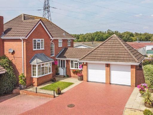 4 bedroom detached house for sale in Bleak House Drive, Burntwood, WS7 — £450,000 • 4 bed • 2 bath • 1249 ft²
 3 bedroom detached house for sale in Glenmore Avenue, Burntwood, WS7 — £280,000 • 3 bed • 1 bath • 1109 ft²
 3 bedroom semi-detached house for sale in Highfield Road, Burntwood, WS7 — £230,000 • 3 bed • 1 bath • 745 ft²
 4 bedroom detached house for sale in St. Peters Road, Burntwood, WS7 — £350,000 • 4 bed • 1 bath • 808 ft²
 3 bedroom detached house for sale in Greyhound Close, Burntwood, WS7 — £367,500 • 3 bed • 3 bath • 1333 ft²
Meta
- {
"@context": "https://schema.org",
"@type": "Residence",
"name": "3 bedroom detached house for sale in Highfield Road, Burntw…",
"description": "",
"url": "https://propertypiper.co.uk/property/0c91ce9d-0634-4778-a6da-2f49c9b58322",
"image": "https://image-a.propertypiper.co.uk/24fa9c84-561e-46a5-95ea-7ab8188a9b4a-1024.jpeg",
"address": {
"@type": "PostalAddress",
"streetAddress": "75, HIGHFIELD ROAD, BURNTWOOD",
"postalCode": "WS7 9BY",
"addressLocality": "Lichfield",
"addressRegion": "Lichfield",
"addressCountry": "England"
},
"geo": {
"@type": "GeoCoordinates",
"latitude": 52.6829091,
"longitude": -1.9119659
},
"numberOfRooms": 3,
"numberOfBathroomsTotal": 1,
"floorSize": {
"@type": "QuantitativeValue",
"value": 829,
"unitCode": "FTK"
},
"offers": {
"@type": "Offer",
"price": 350000,
"priceCurrency": "GBP",
"availability": "https://schema.org/InStock"
},
"additionalProperty": [
{
"@type": "PropertyValue",
"name": "Feature",
"value": "detached house"
},
{
"@type": "PropertyValue",
"name": "Feature",
"value": "1970s"
},
{
"@type": "PropertyValue",
"name": "Feature",
"value": "suburban"
},
{
"@type": "PropertyValue",
"name": "Feature",
"value": "garage"
},
{
"@type": "PropertyValue",
"name": "Feature",
"value": "garden"
},
{
"@type": "PropertyValue",
"name": "Feature",
"value": "brick exterior"
},
{
"@type": "PropertyValue",
"name": "Feature",
"value": "two-story"
},
{
"@type": "PropertyValue",
"name": "Feature",
"value": "driveway"
},
{
"@type": "PropertyValue",
"name": "Feature",
"value": "residential"
},
{
"@type": "PropertyValue",
"name": "Feature",
"value": "family home"
},
{
"@type": "PropertyValue",
"name": "Feature",
"value": "living room"
},
{
"@type": "PropertyValue",
"name": "Feature",
"value": "mid-20th century"
},
{
"@type": "PropertyValue",
"name": "Feature",
"value": "traditional style"
},
{
"@type": "PropertyValue",
"name": "Feature",
"value": "brick fireplace"
},
{
"@type": "PropertyValue",
"name": "Feature",
"value": "large window"
},
{
"@type": "PropertyValue",
"name": "Feature",
"value": "ceiling molding"
},
{
"@type": "PropertyValue",
"name": "Feature",
"value": "traditional lighting"
},
{
"@type": "PropertyValue",
"name": "Feature",
"value": "retro decor"
}
]
}
High Res Floorplan Images
Compatible Floorplan Images
FloorplanImages Thumbnail