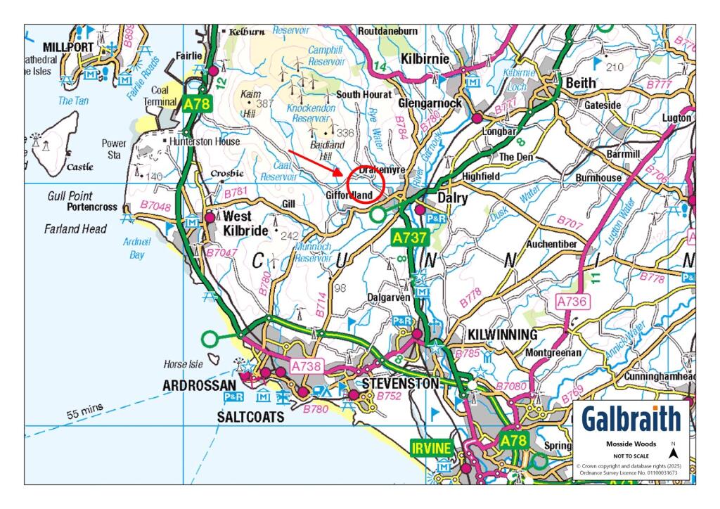
KA24 5HP - Land for sale in Mosside Woods, Dalry, North Ayrshire, KA24
View on Property Piper
Land for sale in Mosside Woods, Dalry, North Ayrshire, KA24
Property Details
- Price: £450000
- Bedrooms: 1
- Bathrooms: 1
- Property Type: undefined
- Property SubType: undefined
Brochure Descriptions
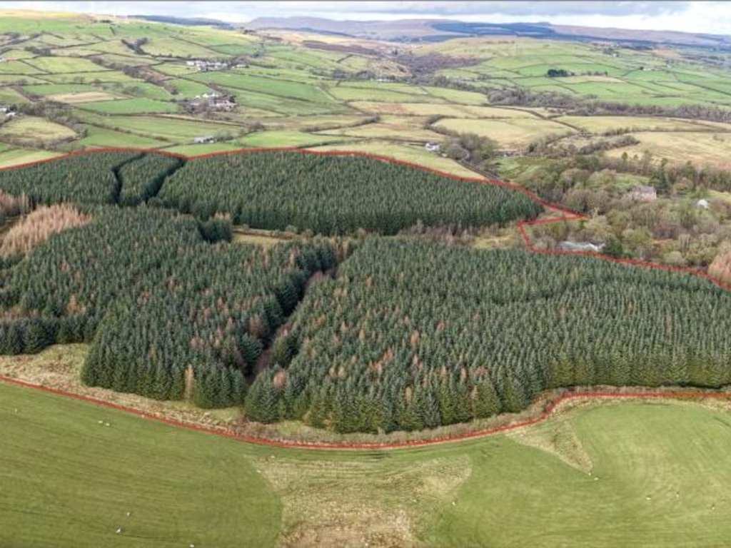
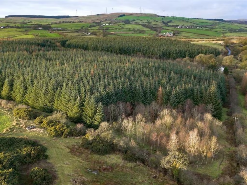
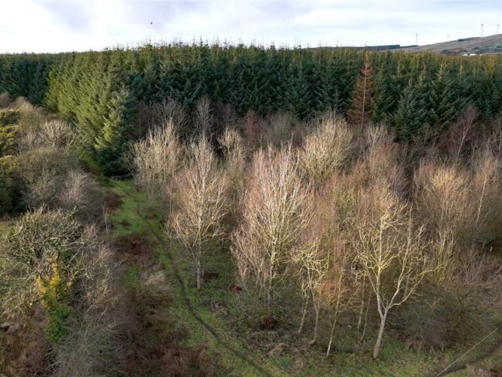
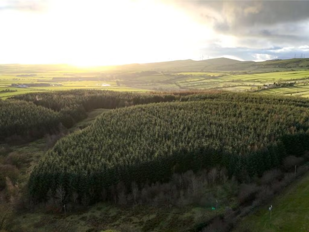
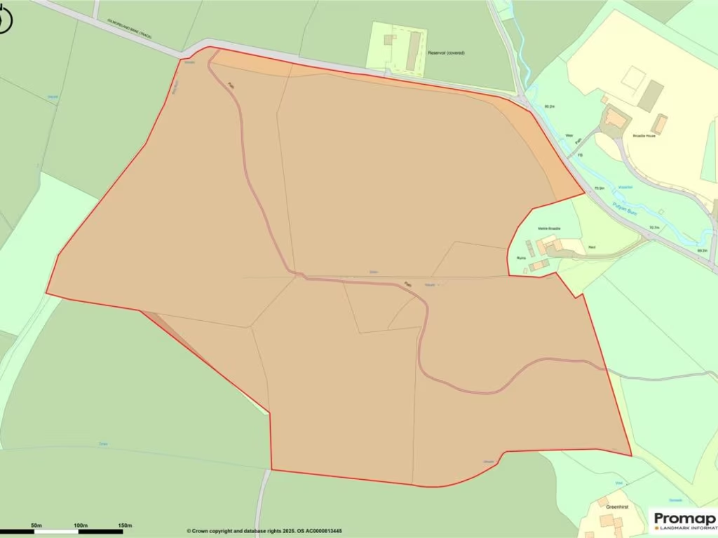
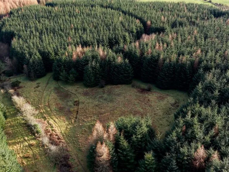
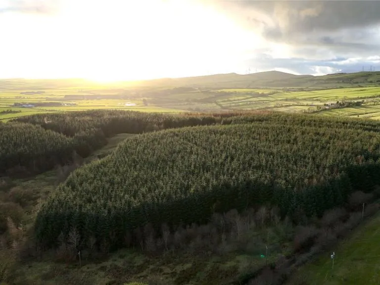
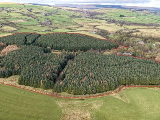
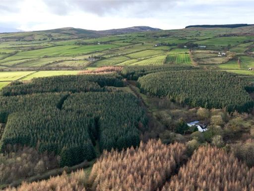
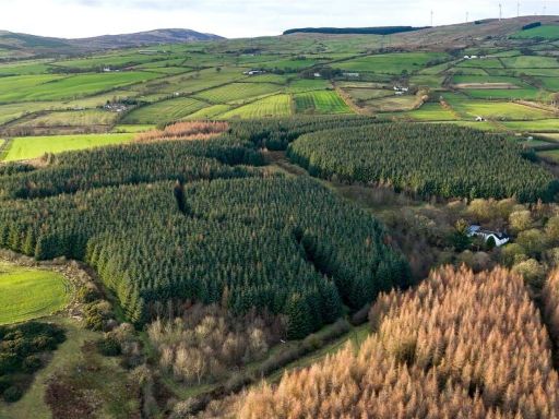
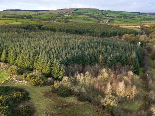
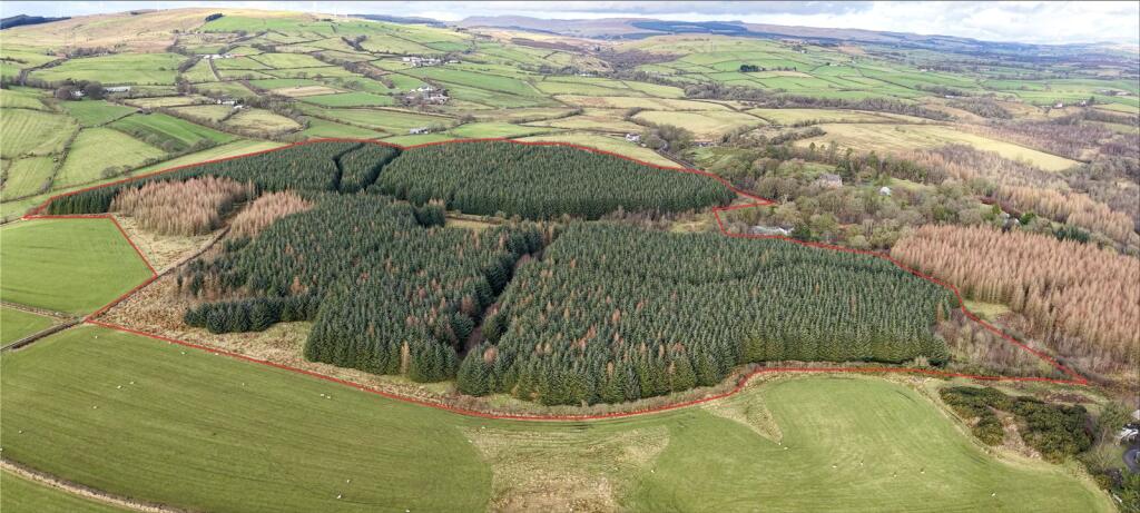
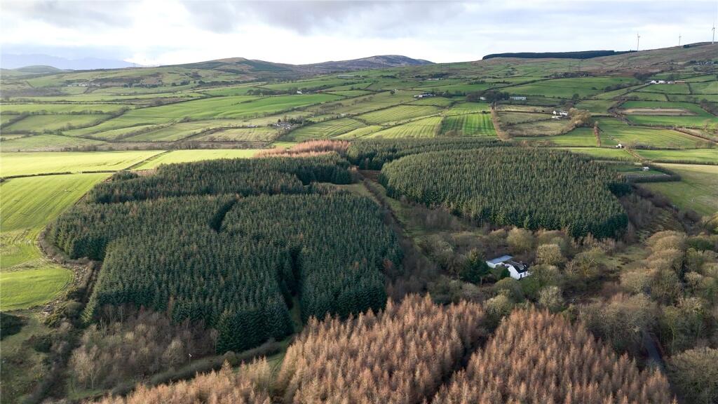
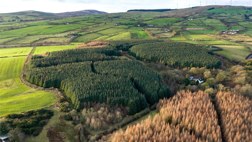
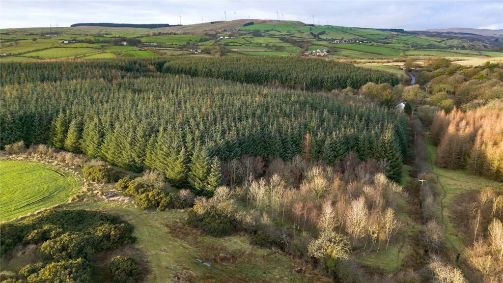
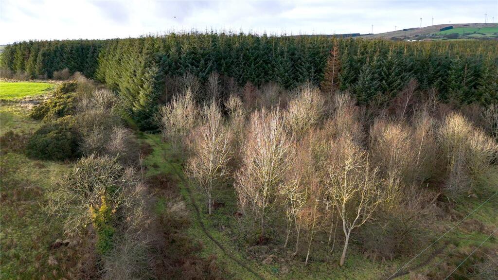
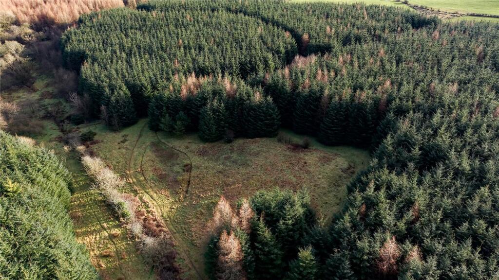
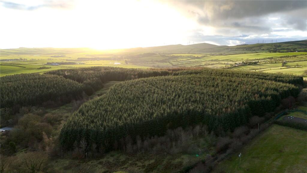
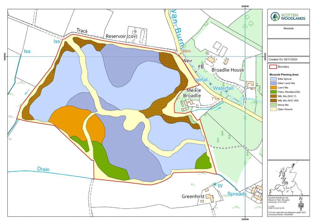
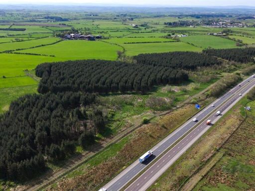
- This expansive property is characterized by its lush, forested landscape, suitable for those seeking tranquility amidst nature. The property boasts extensive views of scenic rolling hills and vast greenery, typical of the picturesque North Ayrshire countryside. The wooded area provides privacy and a sense of seclusion, making it ideal for countryside living. Though the specifics of the residential structure are not visible, the property itself appears sizable, suggesting ample space for residential development or recreational purposes. The views and natural surroundings are exceptional, offering a peaceful retreat.
- The property is situated in a vast, scenic rural landscape, surrounded by lush green fields and dense forests. There are panoramic views of rolling hills and vibrant countryside, creating an idyllic setting for a peaceful residential property. Based on the image, the property is likely large, offering expansive grounds with potential for outdoor activities or development. The views are exceptional, highlighting the natural beauty and tranquility of the area, perfect for those seeking privacy and a connection with nature.
- Located in a picturesque rural setting, this expansive property encompasses large sections of lush woodland bordered by scenic rolling hills. The property is characterized by dense forests and open green fields, perfect for nature enthusiasts or those seeking a tranquil sanctuary. The landscape offers exceptional countryside views, with large stretches of well-maintained forested areas. The overall size of the property is considerable, ideal for diverse forestry applications or a private estate development.
Textual Property Features
Detected Visual Features
- forested land
- rural
- agricultural
- undeveloped
- woodland
- nature
- investment
- timberland
- countryside
- land
- forest
- acreage
- scenic
- privacy
- expanse
Nearest Bars And Restaurants
- Id: 2698216565
- Tags:
- TagsNormalized:
- Lat: 55.6539761
- Lon: -4.6985782
- FullGeoHash: gcust56xgjn4
- PartitionGeoHash: gcus
- Images:
- FoodStandards: null
- Distance: 6933.1
,- Id: 2394179231
- Tags:
- Addr:
- City: Kilwinning
- Housenumber: 68-78
- Postcode: KA13 6JU
- Street: Byres Road
- Amenity: pub
- Name: Taylor's
- Operator: Free House
- Website: http://taylorshotel.co.uk/
- TagsNormalized:
- Lat: 55.654787
- Lon: -4.708321
- FullGeoHash: gcussges8hm2
- PartitionGeoHash: gcus
- Images:
- FoodStandards: null
- Distance: 6628.6
,- Id: 3214964700
- Tags:
- Amenity: cafe
- Name: The Millers Kitchen and Coffee Room
- TagsNormalized:
- Lat: 55.6760246
- Lon: -4.7102304
- FullGeoHash: gcusszd07ejx
- PartitionGeoHash: gcus
- Images:
- FoodStandards: null
- Distance: 4403.1
,- Id: 301609760
- Tags:
- Amenity: pub
- Building: yes
- Name: Dalry Inn
- TagsNormalized:
- Lat: 55.7230293
- Lon: -4.7169674
- FullGeoHash: gcuth8j4ntw1
- PartitionGeoHash: gcut
- Images:
- FoodStandards: null
- Distance: 2069.9
,- Id: 506098294
- Tags:
- Addr:
- City: Dalry
- Housename: Drumastle Mill Cottage
- Postcode: KA24 4LN
- Amenity: restaurant
- Building: yes
- Building:levels: 1
- Fhrs:
- Name: Braidwoods
- Phone: +44 1294 833544
- Source:
- Addr:
- Postcode: code-point_open
- Stars: 1
- Website: https://www.braidwoods.co.uk/
- TagsNormalized:
- Lat: 55.6948369
- Lon: -4.7424056
- FullGeoHash: gcusu4ftvyn5
- PartitionGeoHash: gcus
- Images:
- FoodStandards: null
- Distance: 1819.7
}
Nearest General Shops
- Id: 5218431503
- Tags:
- TagsNormalized:
- Lat: 55.7077155
- Lon: -4.7191897
- FullGeoHash: gcusut78fyv4
- PartitionGeoHash: gcus
- Images:
- FoodStandards: null
- Distance: 1510.1
,- Id: 5218425448
- Tags:
- Name: The Wee Pound Shop
- Shop: discount
- TagsNormalized:
- Lat: 55.7080328
- Lon: -4.7191897
- FullGeoHash: gcusut7dfcvp
- PartitionGeoHash: gcus
- Images:
- FoodStandards: null
- Distance: 1501.5
,- Id: 743735892
- Tags:
- Addr:
- City: Dalry
- Postcode: KA24 5JD
- Street: Braehead
- Building: retail
- Building:levels: 1
- Name: The Original Factory Shop
- Opening_hours: Mo-Fr 09:00-17:30, Sa 09:00-18:00, Su 10:00-17:00
- Payment:
- Cash: yes
- Credit_cards: yes
- Debit_cards: yes
- Phone: +44 1294 832791
- Shop: department_store
- Url: https://www.tofs.com/stores/dalry/
- TagsNormalized:
- retail
- shop
- department store
- Lat: 55.7135792
- Lon: -4.7204867
- FullGeoHash: gcusuw6eheyj
- PartitionGeoHash: gcus
- Images:
- FoodStandards: null
- Distance: 1403.3
}
Nearest Grocery shops
- Id: 3960788645
- Tags:
- TagsNormalized:
- Lat: 55.7469884
- Lon: -4.6868838
- FullGeoHash: gcutjk7jexy4
- PartitionGeoHash: gcut
- Images:
- FoodStandards: null
- Distance: 5287.4
,- Id: 3960788757
- Tags:
- Name: Glengarnock Stores
- Shop: convenience
- TagsNormalized:
- Lat: 55.7392599
- Lon: -4.6774883
- FullGeoHash: gcutje1bwx5u
- PartitionGeoHash: gcut
- Images:
- FoodStandards: null
- Distance: 5128.5
,- Id: 3969485403
- Tags:
- Addr:
- City: Killbirnie
- Country: GB
- Housenumber: 74
- Postcode: KA25 6DN
- Street: Mossend Avenue
- Fhrs:
- Name: Attwal Stores
- Shop: convenience
- TagsNormalized:
- Lat: 55.7473808
- Lon: -4.6930979
- FullGeoHash: gcutjhw84bux
- PartitionGeoHash: gcut
- Images:
- FoodStandards:
- Id: 529275
- FHRSID: 529275
- LocalAuthorityBusinessID: 72392
- BusinessName: Attwal Stores
- BusinessType: Retailers - other
- BusinessTypeID: 4613
- AddressLine1: null
- AddressLine2: 74 Mossend Avenue
- AddressLine3: Kilbirnie
- AddressLine4: Ayrshire
- PostCode: KA25 6DN
- RatingValue: Pass
- RatingKey: fhis_pass_en-GB
- RatingDate: 2018-02-02
- LocalAuthorityCode: 765
- LocalAuthorityName: North Ayrshire
- LocalAuthorityWebSite: http://www.north-ayrshire.gov.uk/PlanningAndTheEnvironment/EnvironmentalHealth/EnvironmentalHealth-Food/FoodHygieneInformationScheme.aspx
- LocalAuthorityEmailAddress: environmentalhealth@north-ayrshire.gov.uk
- Scores:
- Hygiene: null
- Structural: null
- ConfidenceInManagement: null
- NewRatingPending: false
- Geocode:
- Longitude: -4.69266600000000
- Latitude: 55.74764700000000
- Distance: 5074.2
}
Nearest Supermarkets
- Id: 297012553
- Tags:
- Brand: Tesco
- Brand:wikidata: Q487494
- Brand:wikipedia: en:Tesco
- Building: yes
- Contact:
- Website: https://www.tesco.com/store-locator/kilbirnie/bridgend
- Name: Tesco
- Shop: supermarket
- TagsNormalized:
- Lat: 55.7555893
- Lon: -4.6823663
- FullGeoHash: gcutjmyrugnt
- PartitionGeoHash: gcut
- Images:
- FoodStandards: null
- Distance: 6207.2
,- Id: 5218413912
- Tags:
- Name: Co-op
- Shop: supermarket
- TagsNormalized:
- Lat: 55.7079072
- Lon: -4.7194014
- FullGeoHash: gcusut76jfx6
- PartitionGeoHash: gcus
- Images:
- FoodStandards: null
- Distance: 1491.9
,- Id: 390017111
- Tags:
- Addr:
- City: Dalry
- Housenumber: 2
- Postcode: KA24 4LA
- Street: Kilwinning Road
- Brand: Lidl
- Brand:wikidata: Q151954
- Brand:wikipedia: en:Lidl
- Building: supermarket
- Fhrs:
- Name: Lidl
- Shop: supermarket
- TagsNormalized:
- Lat: 55.7042772
- Lon: -4.7249836
- FullGeoHash: gcusukxkgvuu
- PartitionGeoHash: gcus
- Images:
- FoodStandards:
- Id: 529862
- FHRSID: 529862
- LocalAuthorityBusinessID: 75160
- BusinessName: Lidl
- BusinessType: Retailers - supermarkets/hypermarkets
- BusinessTypeID: 7840
- AddressLine1: null
- AddressLine2: 2 Kilwinning Road
- AddressLine3: Dalry
- AddressLine4: Ayrshire
- PostCode: KA24 4LA
- RatingValue: Pass
- RatingKey: fhis_pass_en-GB
- RatingDate: 2019-01-15
- LocalAuthorityCode: 765
- LocalAuthorityName: North Ayrshire
- LocalAuthorityWebSite: http://www.north-ayrshire.gov.uk/PlanningAndTheEnvironment/EnvironmentalHealth/EnvironmentalHealth-Food/FoodHygieneInformationScheme.aspx
- LocalAuthorityEmailAddress: environmentalhealth@north-ayrshire.gov.uk
- Scores:
- Hygiene: null
- Structural: null
- ConfidenceInManagement: null
- NewRatingPending: false
- Geocode:
- Longitude: -4.72499100000000
- Latitude: 55.70431800000000
- Distance: 1339.9
}
Nearest Religious buildings
- Id: 285870932
- Tags:
- Addr:
- City: West Kilbride
- Postcode: KA23 9AW
- Street: Main Street
- Amenity: place_of_worship
- Building: church
- Denomination: protestant
- Name: West Kilbride Parish Church
- Religion: christian
- Website: https://westkilbrideparishchurch.org.uk/
- TagsNormalized:
- place of worship
- church
- protestant
- parish
- christian
- Lat: 55.6960688
- Lon: -4.8546942
- FullGeoHash: gcusce0vj7tx
- PartitionGeoHash: gcus
- Images:
- FoodStandards: null
- Distance: 7228.9
,- Id: 486746004
- Tags:
- Amenity: place_of_worship
- Building: yes
- Denomination: church_of_scotland
- Name: Mansefield Trinity Church
- Religion: christian
- TagsNormalized:
- place of worship
- church
- church of scotland
- christian
- Lat: 55.6520697
- Lon: -4.7186532
- FullGeoHash: gcusse5uz3tn
- PartitionGeoHash: gcus
- Images:
- FoodStandards: null
- Distance: 6742.8
,- Id: 3951494869
- Tags:
- Amenity: place_of_worship
- Religion: christian
- TagsNormalized:
- place of worship
- christian
- church
- Lat: 55.7081929
- Lon: -4.7206939
- FullGeoHash: gcusut67xzgd
- PartitionGeoHash: gcus
- Images:
- FoodStandards: null
- Distance: 1405.7
}
Nearest Medical buildings
- Id: 301344435
- Tags:
- Addr:
- City: West Kilbride
- Housenumber: 107b
- Postcode: KA23 9AL
- Street: Main Street
- Amenity: doctors
- Building: yes
- Building:levels: 1
- Emergency: no
- Healthcare: doctor
- Name: West Kilbride Medical Practice
- TagsNormalized:
- doctor
- doctors
- health
- healthcare
- Lat: 55.6950449
- Lon: -4.8575048
- FullGeoHash: gcusc6yz5uvg
- PartitionGeoHash: gcus
- Images:
- FoodStandards: null
- Distance: 7427.1
,- Id: 3960659847
- Tags:
- Amenity: pharmacy
- Brand: Boots
- Brand:wikidata: Q6123139
- Brand:wikipedia: en:Boots UK
- Healthcare: pharmacy
- Name: Boots
- TagsNormalized:
- pharmacy
- boots
- health
- healthcare
- Lat: 55.747301
- Lon: -4.6865566
- FullGeoHash: gcutjk7re645
- PartitionGeoHash: gcut
- Images:
- FoodStandards: null
- Distance: 5327
,- Id: 5218422584
- Tags:
- Amenity: pharmacy
- Healthcare: pharmacy
- Name: Gallagher Pharmacy
- TagsNormalized:
- Lat: 55.7082202
- Lon: -4.7197825
- FullGeoHash: gcusut75vhgj
- PartitionGeoHash: gcus
- Images:
- FoodStandards: null
- Distance: 1460.5
,- Id: 1080827139
- Tags:
- Amenity: doctors
- Building: yes
- Healthcare: doctor
- Name: Dalry Health Centre
- TagsNormalized:
- doctor
- doctors
- health
- healthcare
- health centre
- Lat: 55.7061282
- Lon: -4.723331
- FullGeoHash: gcususbxdqvn
- PartitionGeoHash: gcus
- Images:
- FoodStandards: null
- Distance: 1326.1
}
Nearest Airports
- Id: 97095239
- Tags:
- Addr:
- Aerodrome: international
- Aerodrome:type: public
- Aeroway: aerodrome
- Arp: no
- Atis: 121.125
- Ele: 20
- Iata: PIK
- Icao: EGPK
- Is_in: South Ayrshire
- Name: Glasgow Prestwick Airport
- Name_1: Prestwick Airport
- Name_2: Glasgow Prestwick Airport
- Operator: Infratil Airports Europe
- Owner: Infratil
- Size: 1817727
- Tower_frequency: 118.150
- Website: https://www.glasgowprestwick.com/
- Wikidata: Q8992
- Wikipedia: en:Glasgow Prestwick Airport
- TagsNormalized:
- airport
- international airport
- Lat: 55.5022118
- Lon: -4.5948374
- FullGeoHash: gcuexry5ud0v
- PartitionGeoHash: gcue
- Images:
- FoodStandards: null
- Distance: 25020.8
,- Id: 1100796130
- Tags:
- Addr:
- City: Paisley
- Postcode: PA3 2SW
- Aerodrome: international
- Aerodrome:type: public
- Aeroway: aerodrome
- Iata: GLA
- Icao: EGPF
- Ifr: yes
- Is_in: Paisley, Scotland, UK
- Name: Glasgow Airport
- Operator: Glasgow Airport Limited
- Phone: +44 141 887 1111
- Ref: GLA
- Source: CAA AIP
- Wikidata: Q8721
- Wikipedia: en:Glasgow Airport
- TagsNormalized:
- airport
- international airport
- Lat: 55.8705835
- Lon: -4.4351667
- FullGeoHash: gcuvg4fmtpsh
- PartitionGeoHash: gcuv
- Images:
- FoodStandards: null
- Distance: 26138
,- Id: 4519551
- Tags:
- Aerodrome: international
- Name: Glasgow International Airport
- Type: site
- Wikidata: Q8721
- TagsNormalized:
- airport
- international airport
- Lat: 55.8705829
- Lon: -4.4355768
- FullGeoHash: gcuvg4fjexd0
- PartitionGeoHash: gcuv
- Images:
- FoodStandards: null
- Distance: 26119.1
}
Nearest Leisure Facilities
- Id: 390017105
- Tags:
- Leisure: pitch
- Lit: no
- Name: Dalry Thistle F.C.
- Sport: soccer
- Surface: grass
- Wikidata: Q5211611
- Wikipedia: en:Dalry Thistle F.C.
- TagsNormalized:
- Lat: 55.705015
- Lon: -4.7250254
- FullGeoHash: gcusukz34zmt
- PartitionGeoHash: gcus
- Images:
- FoodStandards: null
- Distance: 1292.3
,- Id: 755670808
- Tags:
- Leisure: sports_centre
- Name: Merksworth Park
- Sport: soccer
- TagsNormalized:
- sports
- sports centre
- leisure
- soccer
- Lat: 55.7050648
- Lon: -4.7250931
- FullGeoHash: gcusukz392en
- PartitionGeoHash: gcus
- Images:
- FoodStandards: null
- Distance: 1285.8
,- Id: 391887764
- Tags:
- Leisure: pitch
- Sport: multi
- TagsNormalized:
- Lat: 55.7064058
- Lon: -4.7250833
- FullGeoHash: gcusump33ddw
- PartitionGeoHash: gcus
- Images:
- FoodStandards: null
- Distance: 1213.8
,- Id: 1062077025
- Tags:
- TagsNormalized:
- Lat: 55.705488
- Lon: -4.7317051
- FullGeoHash: gcusukf7zr8g
- PartitionGeoHash: gcus
- Images:
- FoodStandards: null
- Distance: 927.3
,- Id: 1062077022
- Tags:
- TagsNormalized:
- Lat: 55.7080927
- Lon: -4.7319565
- FullGeoHash: gcusum671mjm
- PartitionGeoHash: gcus
- Images:
- FoodStandards: null
- Distance: 744.8
}
Nearest Tourist attractions
- Id: 351522705
- Tags:
- Historic: archaeological_site
- Name: Bushglen Mount
- Tourism: attraction
- TagsNormalized:
- Lat: 55.7090884
- Lon: -4.8482151
- FullGeoHash: gcusctt8uqub
- PartitionGeoHash: gcus
- Images:
- FoodStandards: null
- Distance: 6627.5
,- Id: 301602493
- Tags:
- Addr:
- City: West Kilbride
- Street: Crosbie Towers
- Barrier: fence
- Name: Crosbie Towers
- Tourism: caravan_site
- TagsNormalized:
- Lat: 55.7111798
- Lon: -4.8379224
- FullGeoHash: gcuscvvjhhxs
- PartitionGeoHash: gcus
- Images:
- FoodStandards: null
- Distance: 5978.3
,- Id: 7131574142
- Tags:
- Name: Garden Cottage
- Tourism: chalet
- TagsNormalized:
- Lat: 55.6968927
- Lon: -4.7024582
- FullGeoHash: gcusugrcbv34
- PartitionGeoHash: gcus
- Images:
- FoodStandards: null
- Distance: 2970.2
}
Nearest Bus stations and stops
- Id: 10702409015
- Tags:
- Bus: yes
- Highway: bus_stop
- Public_transport: platform
- TagsNormalized:
- Lat: 55.7432922
- Lon: -4.6440631
- FullGeoHash: gcutn7f21qzd
- PartitionGeoHash: gcut
- Images:
- FoodStandards: null
- Distance: 7121.6
,- Id: 5994362302
- Tags:
- Bus: yes
- Highway: bus_stop
- Public_transport: platform
- TagsNormalized:
- Lat: 55.6545688
- Lon: -4.6974636
- FullGeoHash: gcust5e7m5t6
- PartitionGeoHash: gcus
- Images:
- FoodStandards: null
- Distance: 6900.9
,- Id: 10702400683
- Tags:
- Bus: yes
- Highway: bus_stop
- Public_transport: platform
- TagsNormalized:
- Lat: 55.7433542
- Lon: -4.648399
- FullGeoHash: gcutn5z0s6qk
- PartitionGeoHash: gcut
- Images:
- FoodStandards: null
- Distance: 6891.5
,- Id: 390962184
- Tags:
- Bus: yes
- Highway: bus_stop
- Name: Townhead / Kilwinning Railway Station
- Nat_ref: 6170655
- Public_transport: platform
- TagsNormalized:
- Lat: 55.6559979
- Lon: -4.7096545
- FullGeoHash: gcussgfe9jgp
- PartitionGeoHash: gcus
- Images:
- FoodStandards: null
- Distance: 6474.3
,- Id: 5208950058
- Tags:
- Bus: yes
- Highway: bus_stop
- Public_transport: platform
- TagsNormalized:
- Lat: 55.708885
- Lon: -4.7224029
- FullGeoHash: gcusut3rb0c5
- PartitionGeoHash: gcus
- Images:
- FoodStandards: null
- Distance: 1284.3
}
Nearest Hotels
- Id: 118718434
- Tags:
- Addr:
- City: Seamill
- Postcode: KA23 9ND
- Street: Ardrossan Road
- Building: yes
- Name: Seamill Hydro
- Source: survey & Bing
- Tourism: hotel
- Website: https://www.seamillhydro.co.uk/
- TagsNormalized:
- Lat: 55.6848241
- Lon: -4.8627855
- FullGeoHash: gcusc3558gs6
- PartitionGeoHash: gcus
- Images:
- FoodStandards: null
- Distance: 8088.9
,- Id: 302110810
- Tags:
- Name: The Waterside
- Tourism: hotel
- TagsNormalized:
- Lat: 55.6746012
- Lon: -4.852106
- FullGeoHash: gcus9x6b19zs
- PartitionGeoHash: gcus
- Images:
- FoodStandards: null
- Distance: 7985
,- Id: 435141777
- Tags:
- Building: yes
- Name: The Red Squirell Hotel
- Tourism: hotel
- TagsNormalized:
- Lat: 55.6484575
- Lon: -4.7327688
- FullGeoHash: gcuss63xy2rg
- PartitionGeoHash: gcus
- Images:
- FoodStandards: null
- Distance: 7003.4
}
Tags
- forested land
- rural
- agricultural
- undeveloped
- woodland
- nature
- investment
- timberland
- countryside
- land
- rural
- countryside
- forest
- acreage
- undeveloped
- scenic
- nature
- privacy
- expanse
- investment
Local Market Stats
- Average Price/sqft: £119
- Planning Success Rate: 56%
AirBnB Data
- 1km average: £75/night
- Listings in 1km: 1
Similar Properties
 Land for sale in Laighmuir Woodland, Fenwick, Kilmarnock, East Ayrshire, KA3 — £295,000 • 1 bed • 1 bath
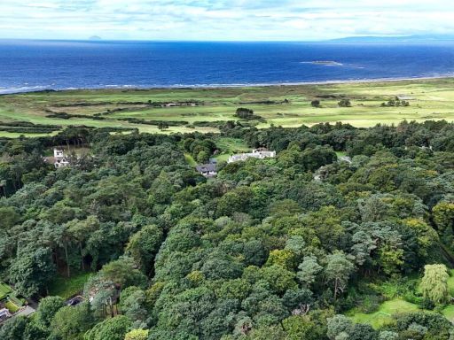 Property for sale in Land Off Southwood Road, Southwood Road, Troon, KA9 — £50,000 • 1 bed • 1 bath
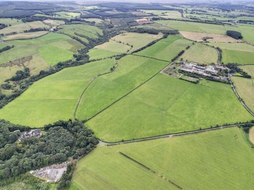 Land for sale in Galston, East Ayrshire, KA4 — £375,000 • 1 bed • 1 bath • 4844 ft²
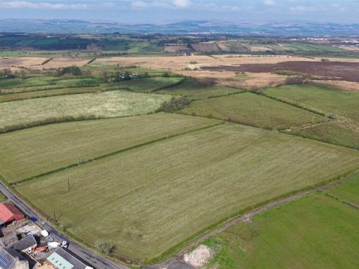 Land for sale in Land At Muir Of Auchenmade, KIlwinning, North Ayrshire, KA13 — £165,000 • 1 bed • 1 bath
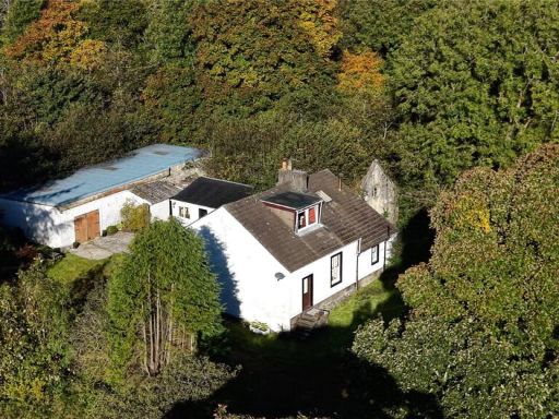 3 bedroom detached house for sale in Meikle Broadlie, Dalry, North Ayrshire, KA24 — £295,000 • 3 bed • 1 bath • 1462 ft²
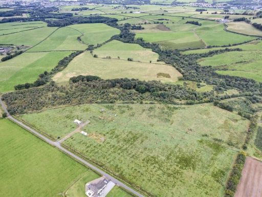 Land for sale in Target Wood, Threepwood Farm, Galston, East Ayrshire, KA4 — £50,000 • 1 bed • 1 bath • 4844 ft²
Meta
- {
"@context": "https://schema.org",
"@type": "Residence",
"name": "Land for sale in Mosside Woods, Dalry, North Ayrshire, KA24",
"description": "",
"url": "https://propertypiper.co.uk/property/072af46d-be8b-46a5-a4d9-5463481064e3",
"image": "https://image-a.propertypiper.co.uk/83ac6b62-815f-4d95-9b71-7e8fb351d856-1024.jpeg",
"address": {
"@type": "PostalAddress",
"streetAddress": "Mosside Woods, Dalry, North Ayrshire, KA24",
"postalCode": "KA24 5HP",
"addressLocality": "North Ayrshire",
"addressRegion": "North Ayrshire and Arran",
"addressCountry": "Scotland"
},
"geo": {
"@type": "GeoCoordinates",
"latitude": 55.7112017057014,
"longitude": -4.742487799061756
},
"numberOfRooms": 1,
"numberOfBathroomsTotal": 1,
"floorSize": {
"@type": "QuantitativeValue",
"value": 301,
"unitCode": "FTK"
},
"offers": {
"@type": "Offer",
"price": 450000,
"priceCurrency": "GBP",
"availability": "https://schema.org/InStock"
},
"additionalProperty": [
{
"@type": "PropertyValue",
"name": "Feature",
"value": "forested land"
},
{
"@type": "PropertyValue",
"name": "Feature",
"value": "rural"
},
{
"@type": "PropertyValue",
"name": "Feature",
"value": "agricultural"
},
{
"@type": "PropertyValue",
"name": "Feature",
"value": "undeveloped"
},
{
"@type": "PropertyValue",
"name": "Feature",
"value": "woodland"
},
{
"@type": "PropertyValue",
"name": "Feature",
"value": "nature"
},
{
"@type": "PropertyValue",
"name": "Feature",
"value": "investment"
},
{
"@type": "PropertyValue",
"name": "Feature",
"value": "timberland"
},
{
"@type": "PropertyValue",
"name": "Feature",
"value": "countryside"
},
{
"@type": "PropertyValue",
"name": "Feature",
"value": "land"
},
{
"@type": "PropertyValue",
"name": "Feature",
"value": "rural"
},
{
"@type": "PropertyValue",
"name": "Feature",
"value": "countryside"
},
{
"@type": "PropertyValue",
"name": "Feature",
"value": "forest"
},
{
"@type": "PropertyValue",
"name": "Feature",
"value": "acreage"
},
{
"@type": "PropertyValue",
"name": "Feature",
"value": "undeveloped"
},
{
"@type": "PropertyValue",
"name": "Feature",
"value": "scenic"
},
{
"@type": "PropertyValue",
"name": "Feature",
"value": "nature"
},
{
"@type": "PropertyValue",
"name": "Feature",
"value": "privacy"
},
{
"@type": "PropertyValue",
"name": "Feature",
"value": "expanse"
},
{
"@type": "PropertyValue",
"name": "Feature",
"value": "investment"
}
]
}