CM15 9JN - 4 bedroom semidetached house for sale in Ongar Road, Pilgri…
View on Property Piper
4 bedroom semi-detached house for sale in Ongar Road, Pilgrims Hatch, Brentwood, Essex, CM15
Property Details
- Price: £690000
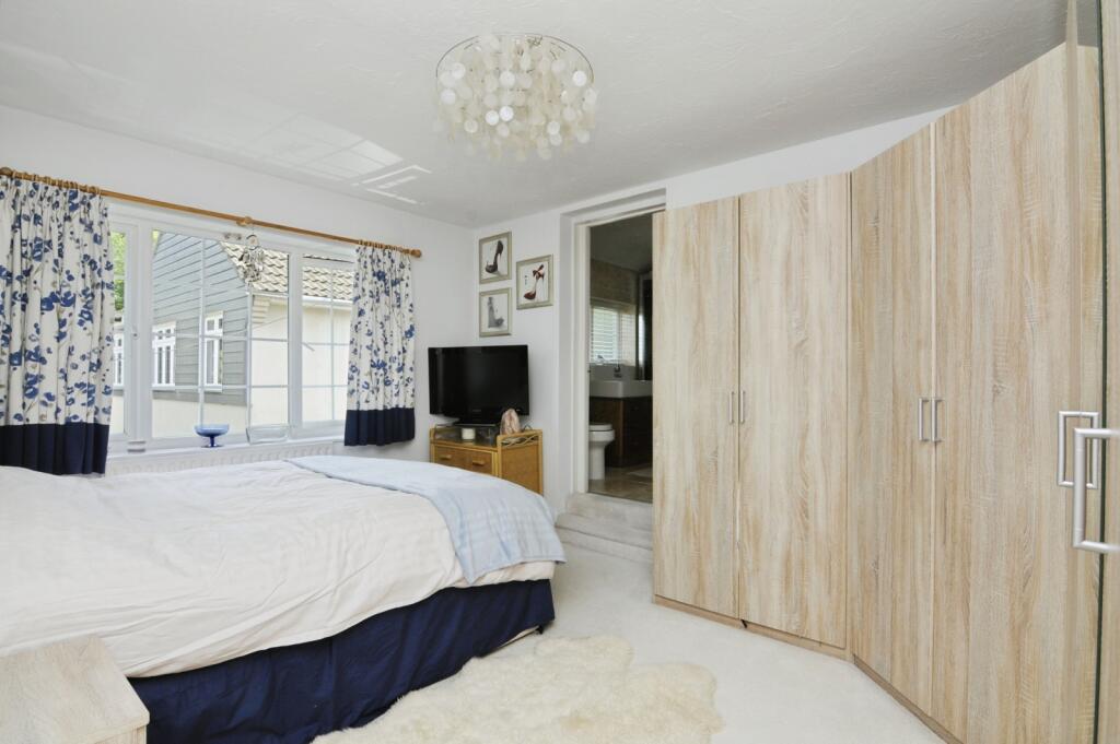
- Bedrooms: 4
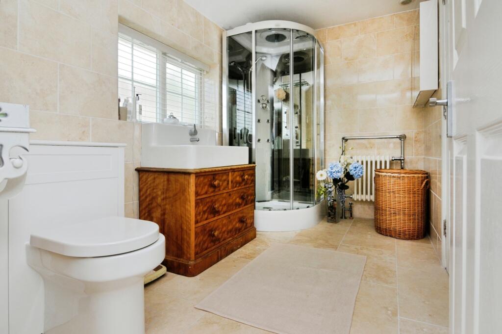
- Bathrooms: 3
- Property Type: undefined
- Property SubType: undefined
Brochure Descriptions
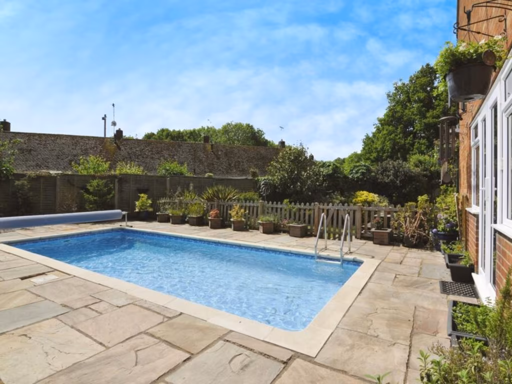
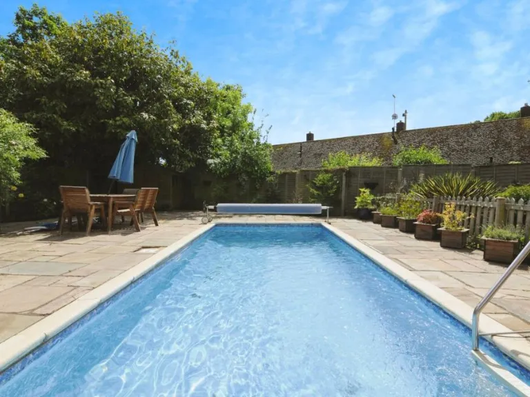
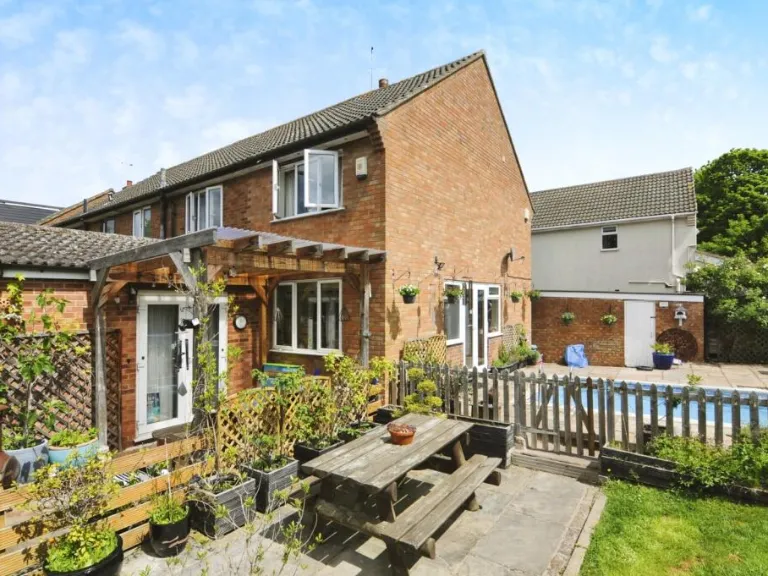
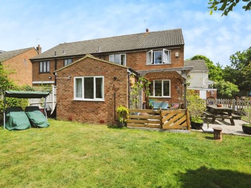
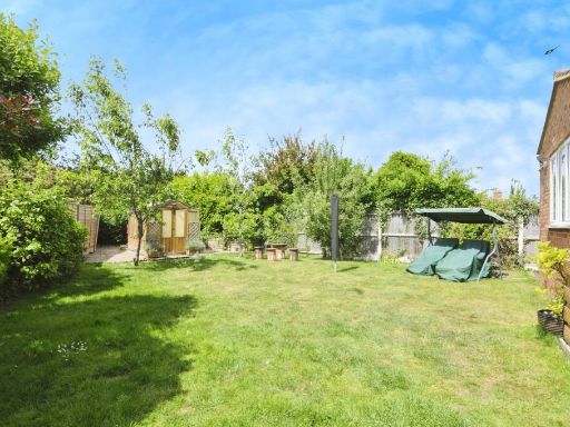
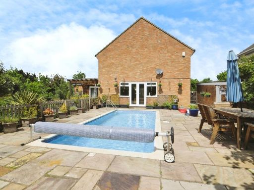
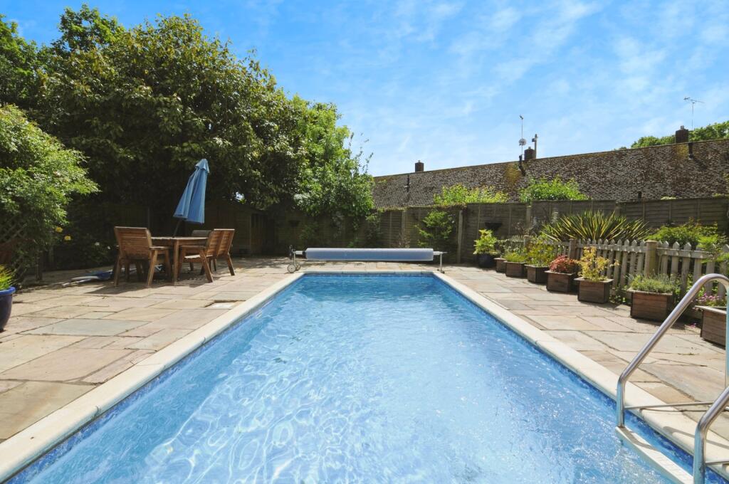
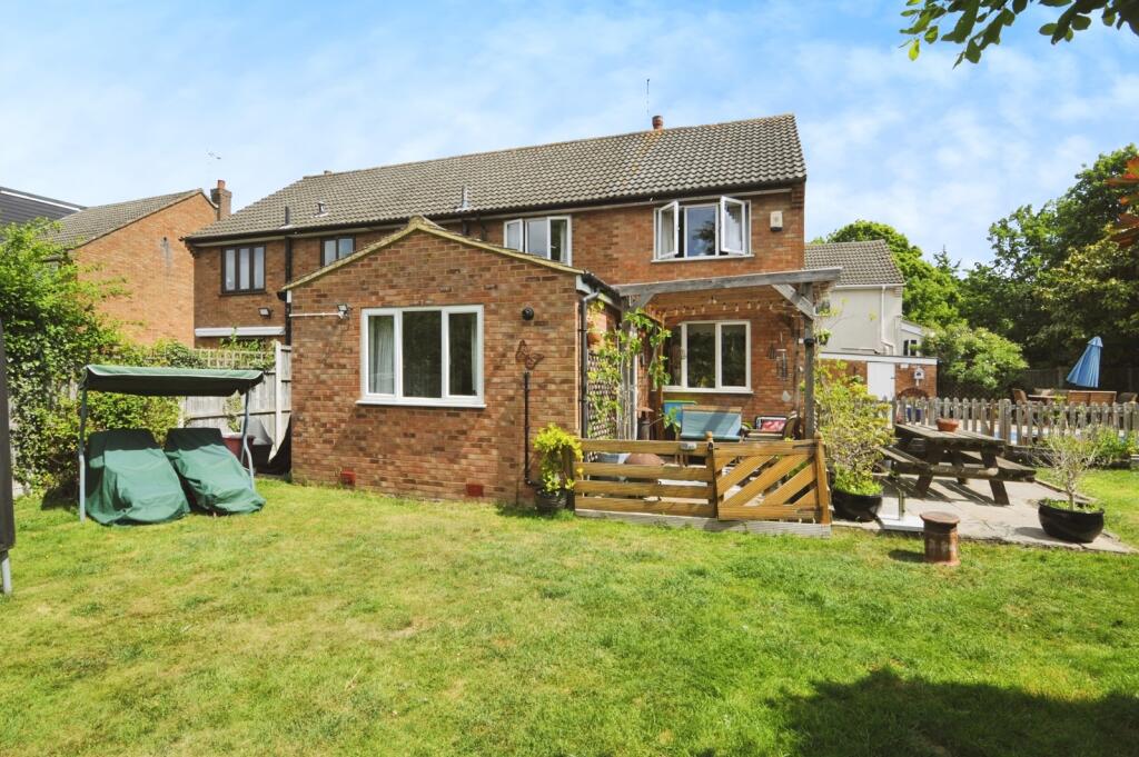
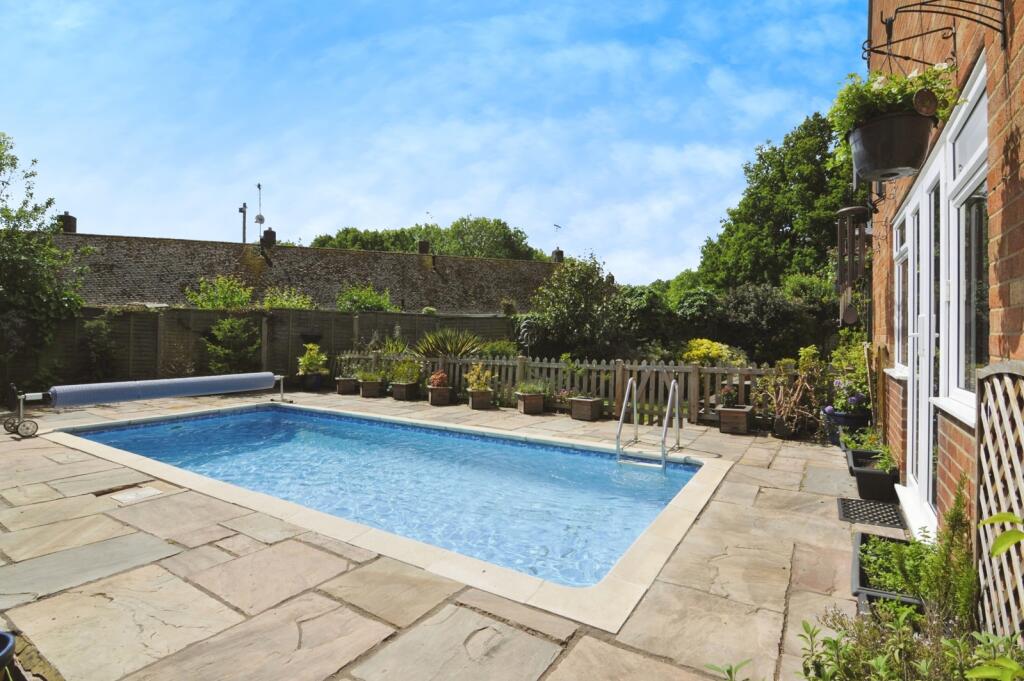
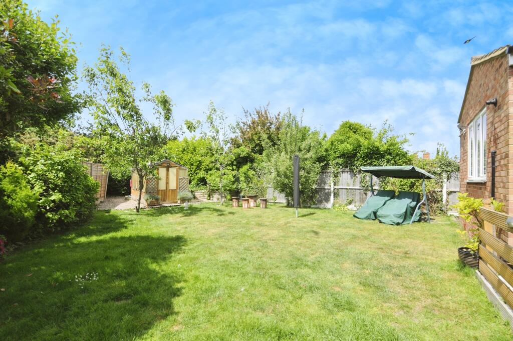
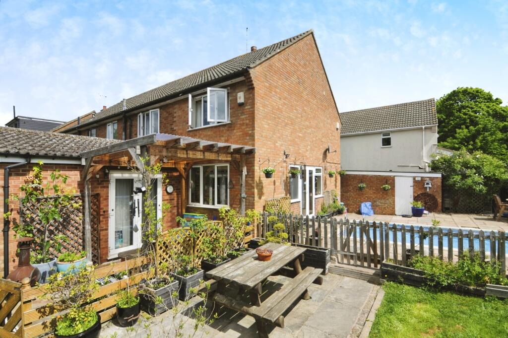
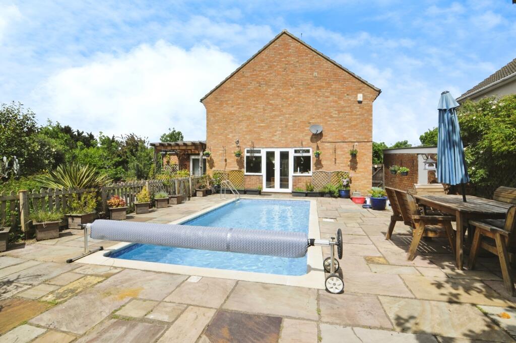
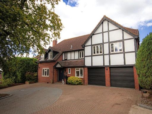
- This property on Ongar Road in Pilgrims Hatch, Brentwood, features an inviting outdoor space highlighted by a medium-sized swimming pool, perfect for leisure and relaxation. The surrounding patio area is paved, offering a low-maintenance space that is ideal for outdoor dining or entertaining guests. The garden is moderately sized, enhancing the private and secluded feel of the backyard, framed by lush greenery and mature trees that provide shade and a sense of tranquility.
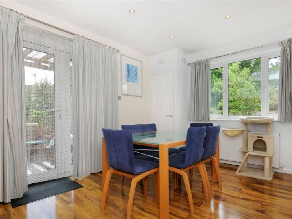
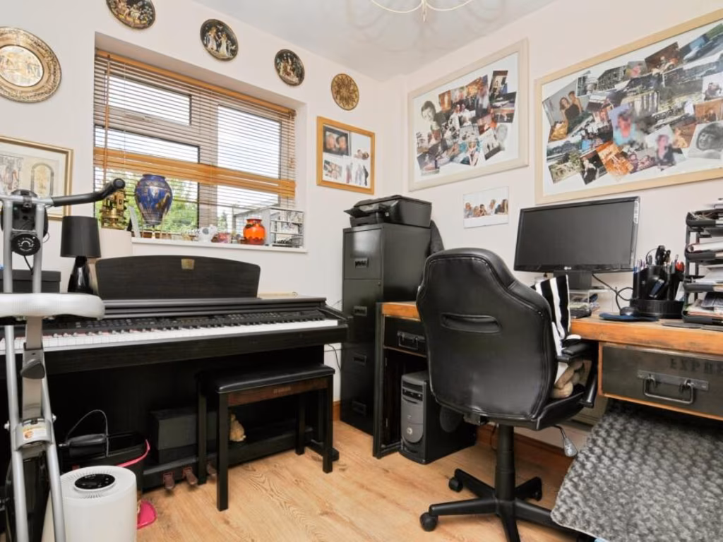
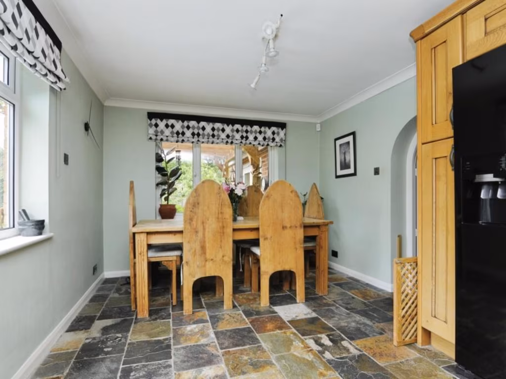
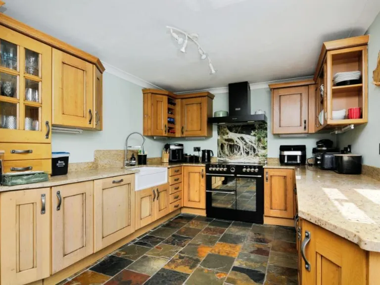
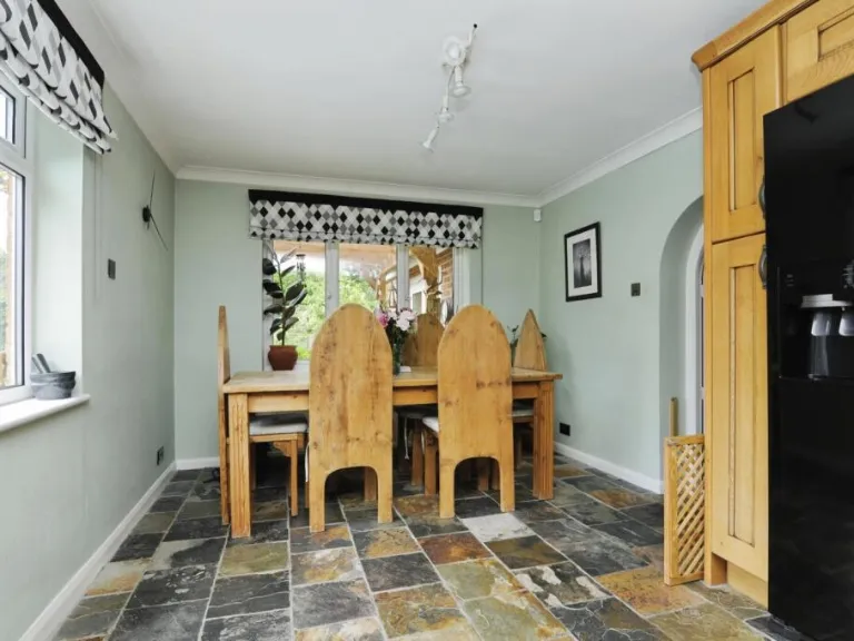
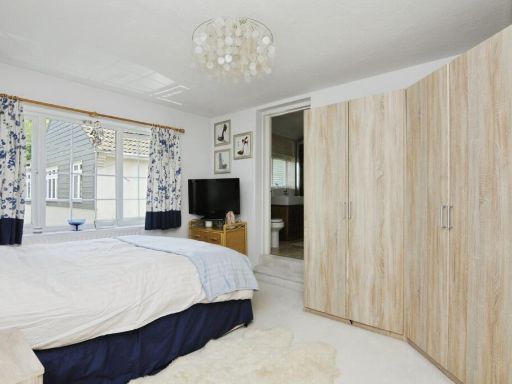
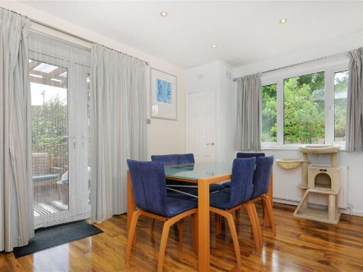
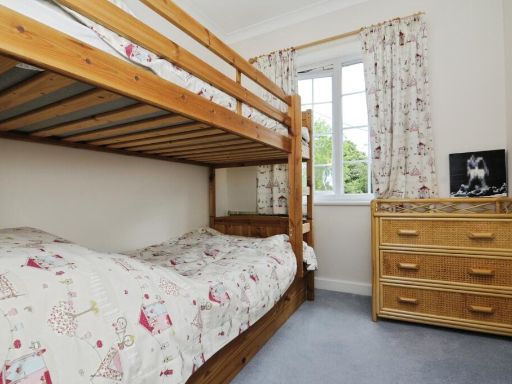
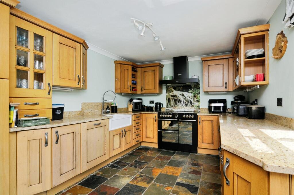
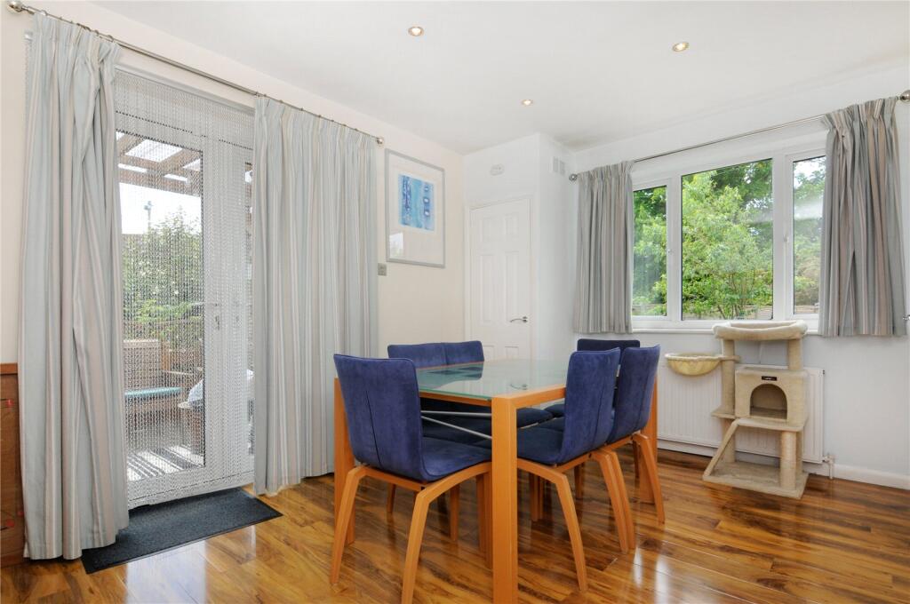
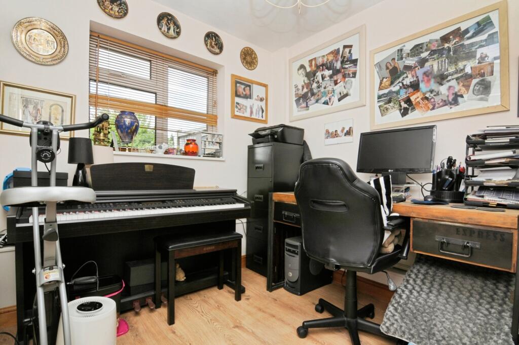
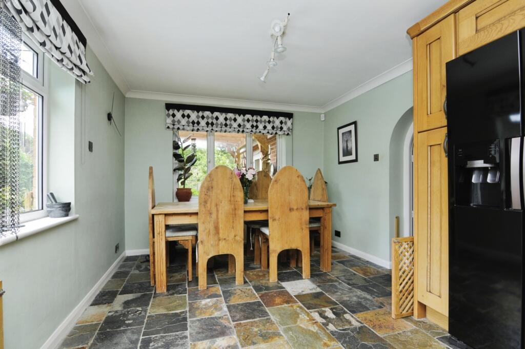
- The property showcases a well-appointed kitchen featuring ample natural light and an extensive array of counter space, accented by warm wooden cabinets and a slate tile floor. Adjacent is a dining area with sufficient space for a medium-sized dining set, ideal for by the window family meals. The property also includes a separate cozy room, possibly utilized as an office or study space, offering an intimate environment enhanced by a bright interior. This setting would appeal greatly to buyers looking for a quiet work-from-home spot or a personalized creative studio. The room sizes are comfortably average, suggesting a mid-sized family home.
Image Descriptions
- outdoor pool area modern
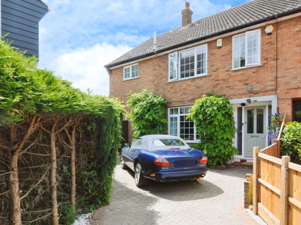
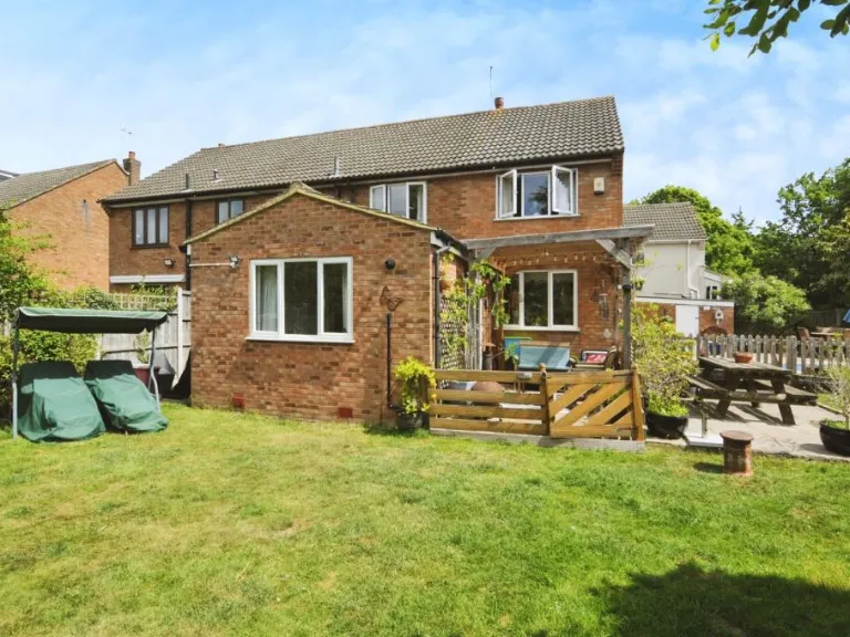
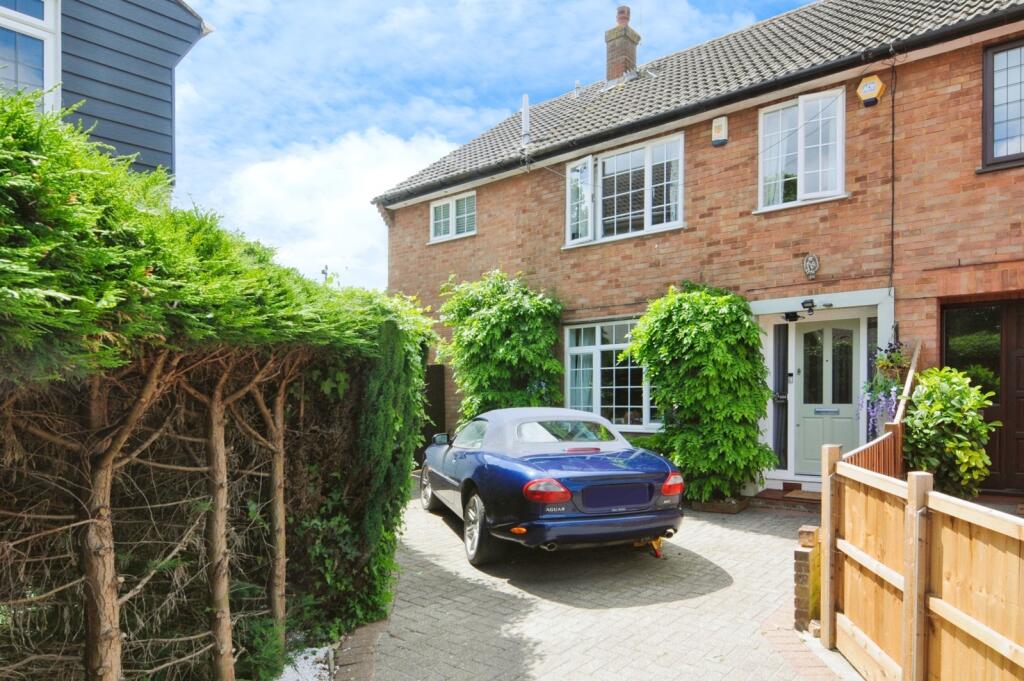
- semi-detached house post-war suburban
Floorplan Description
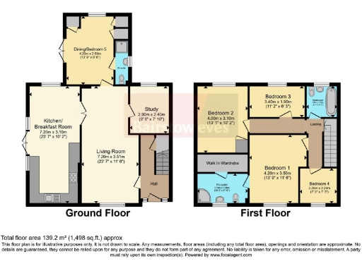
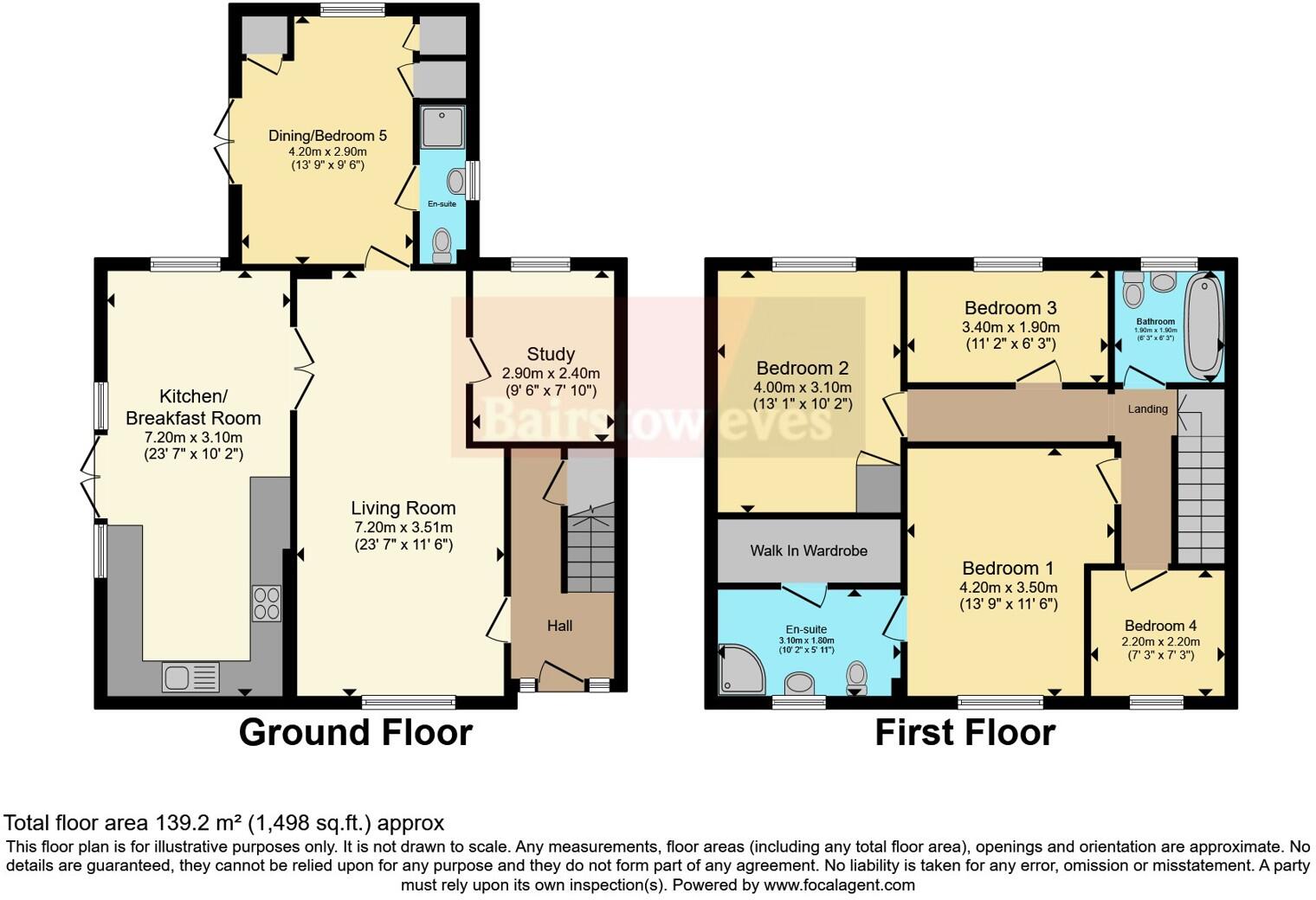
- A two-story property with a mix of bedrooms and common areas, including a kitchen, living room, and study.
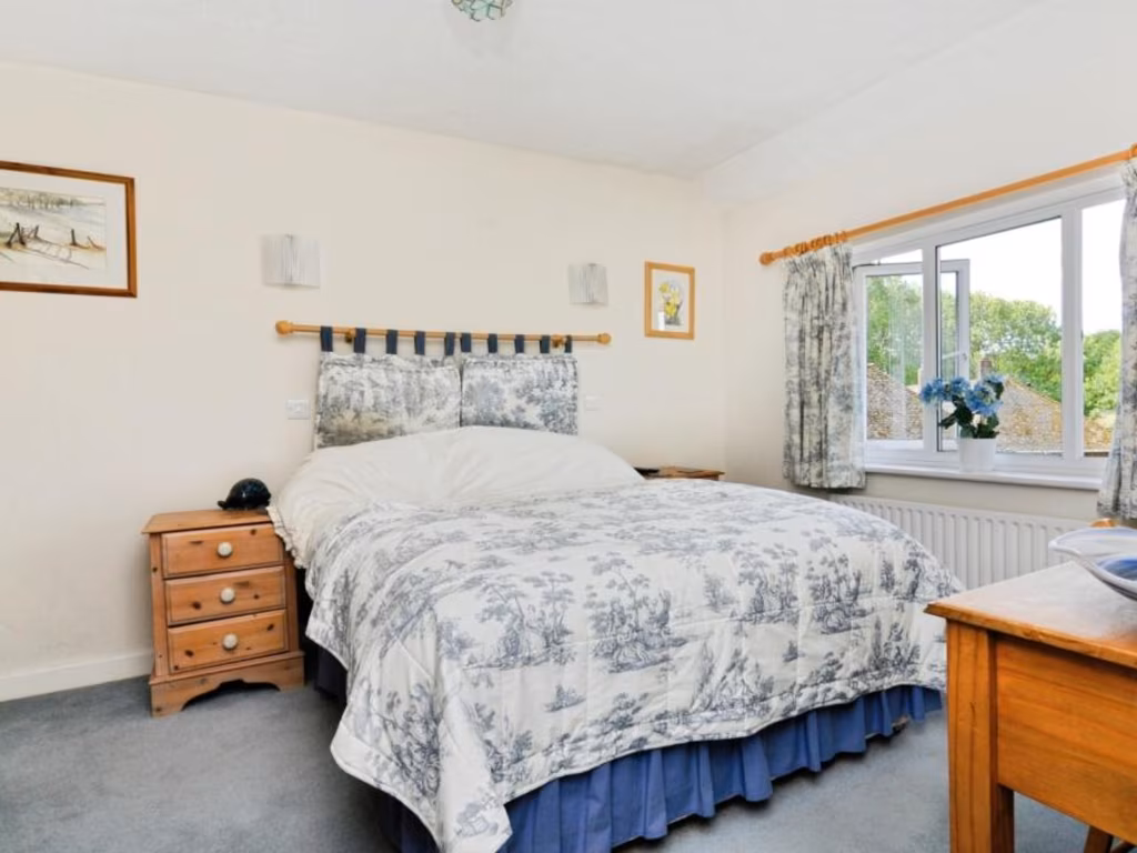
Rooms
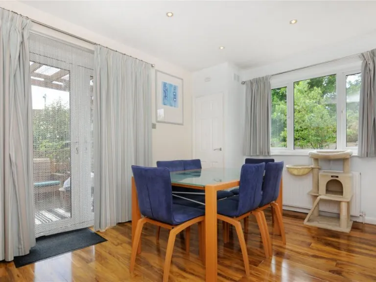
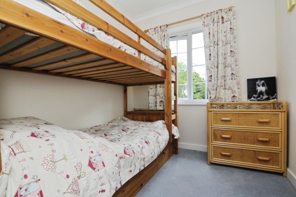
- Dining/Bedroom 5:
- Kitchen/Breakfast Room:
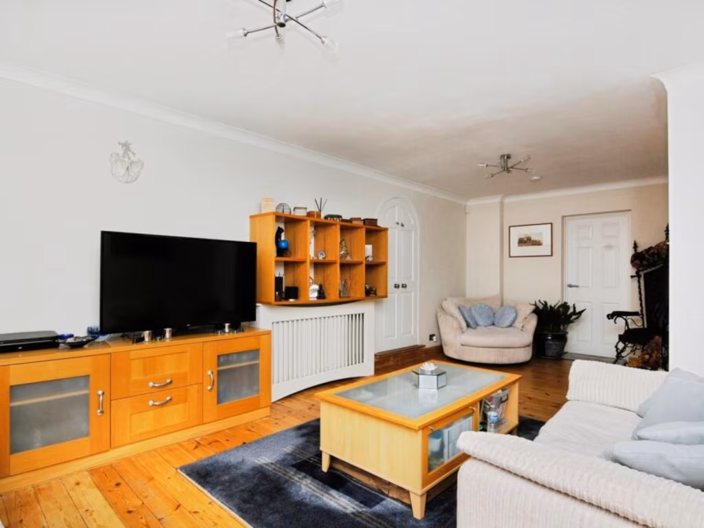
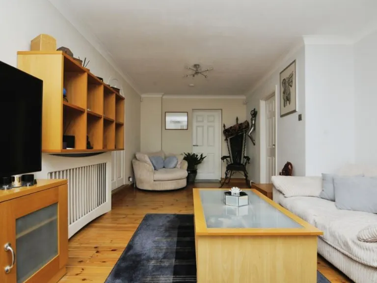
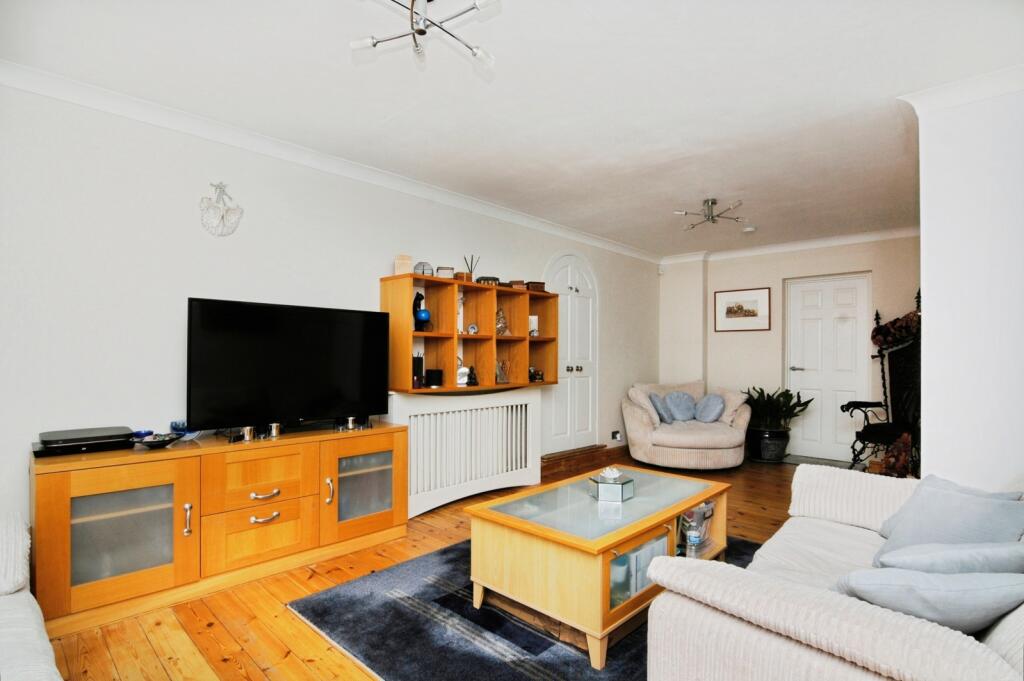
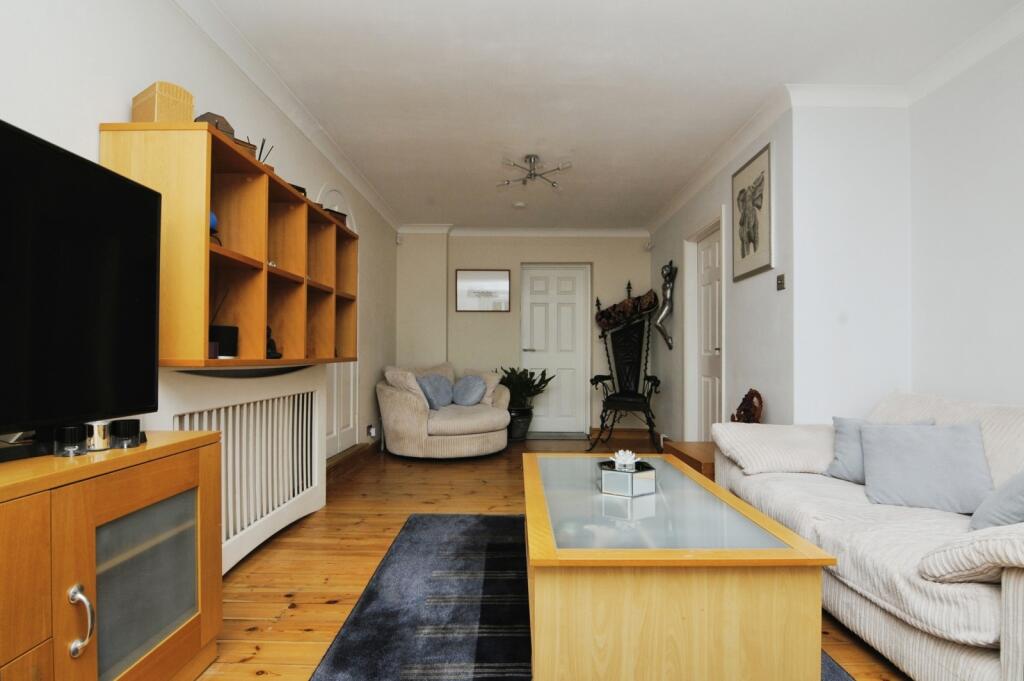
- Living Room:
- Study:
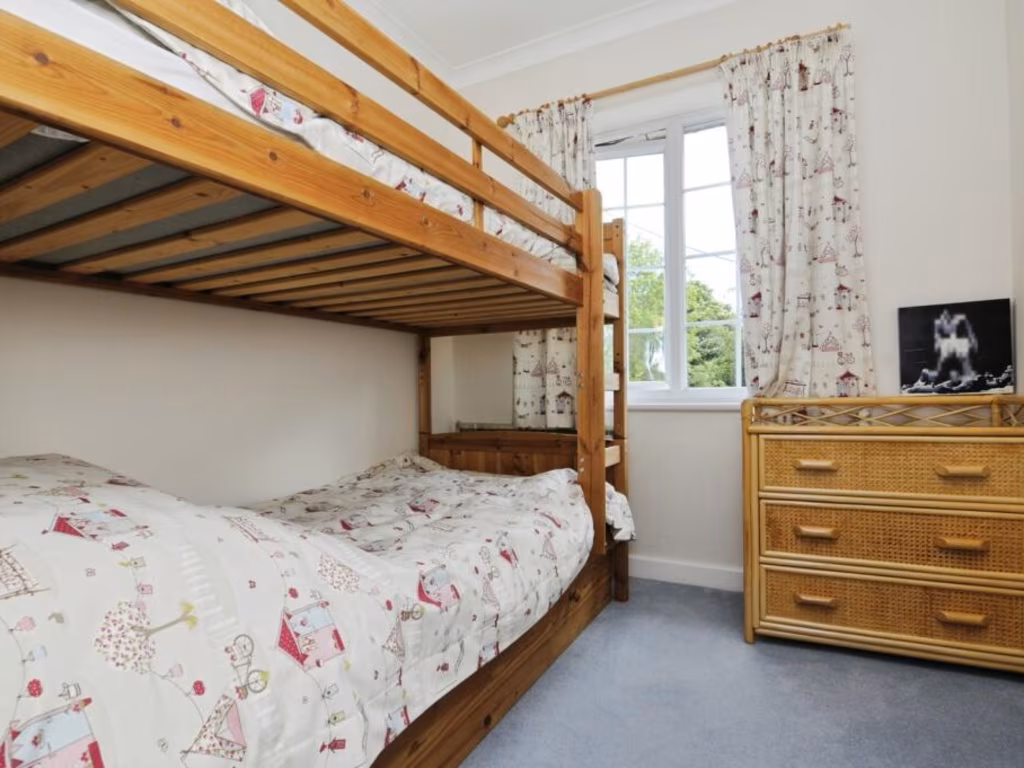
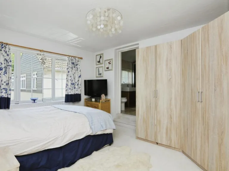
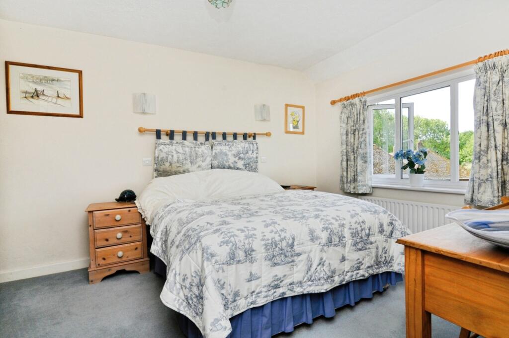
- Bedroom 2:
- Bedroom 3:
- Bedroom 1:
- Bedroom 4:
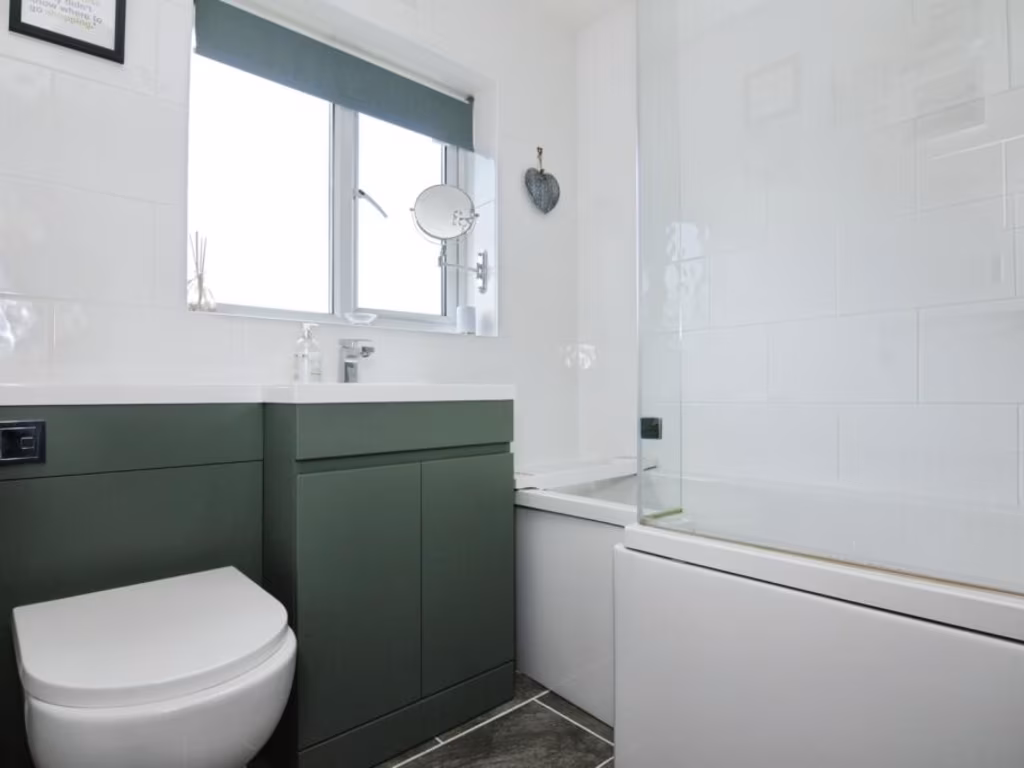
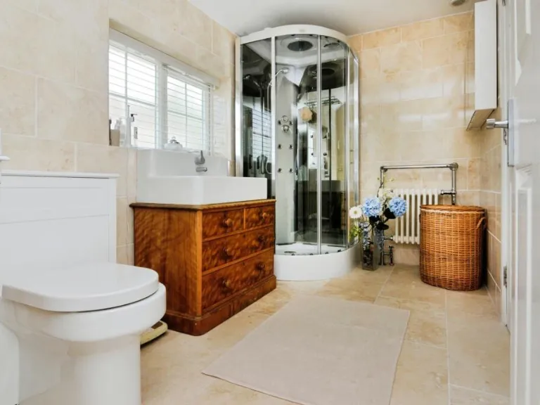
- Bathroom:
Textual Property Features
- Has Garden
- Chain Free
- Success
Detected Visual Features
- property
- swimming pool
- outdoor
- modern
- garden
- landscaped
- patio
- privacy
- large space
- semi-detached
- residential
- brick exterior
- bay window
- chimney
- two-story
- suburban
- driveway
- paved parking
- bushes
- classic design
EPC Details
- Fully double glazed
- Cavity wall, filled cavity
- Boiler and radiators, mains gas
- No low energy lighting
- Solid, no insulation (assumed)
Nearby Schools
- Harold Court Primary School
- Warley Primary School
- Drapers' Academy
- Drapers' Maylands Primary School
- Brentwood School
- Larchwood Primary School
- Kelvedon Hatch Community Primary School
- Drapers' Brookside Junior School
- Drapers' Brookside Infant School
- Brentwood County High School
- Hogarth Primary School
- Brentwood Ursuline Convent High School
- St Helen's Catholic Junior School
- Long Ridings Primary School
- St Thomas of Canterbury Church of England Aided Primary School, Brentwood
- Becket Keys Church of England Free School
- St Helen's Catholic Infant School
- Shenfield St. Mary's Church of England Primary School
- Ursuline Preparatory School
- Mead Primary School
- Drapers' Pyrgo Priory School
- Holly Trees Primary School
- St Peter's Church of England Voluntary Aided Primary School, South Weald
- Shenfield High School
- Bentley St Paul's Church of England Primary School
- Doddinghurst Infant School
- Doddinghurst Church of England Junior School
Nearest Bars And Restaurants
- Id: 7280867860
- Tags:
- Amenity: cafe
- Name: Crumbs
- TagsNormalized:
- Lat: 51.628147
- Lon: 0.295787
- FullGeoHash: u10jwwx7u24u
- PartitionGeoHash: u10j
- Images:
- FoodStandards: null
- Distance: 1586.7
,- Id: 652397823
- Tags:
- Addr:
- City: brentwood
- Housename: The Robin
- Postcode: CM15 9DZ
- Street: Ongar Road
- Amenity: pub
- Brewery: yes
- Building: yes
- Name: Robin Hood Pub
- Opening_hours: Mo-Fr 11:00 - 24:00
- Outdoor_seating: yes
- Smoking: separated
- Survey:
- TagsNormalized:
- Lat: 51.6283103
- Lon: 0.294797
- FullGeoHash: u10jwwwstq8e
- PartitionGeoHash: u10j
- Images:
- FoodStandards: null
- Distance: 1524.1
,- Id: 1047462857
- Tags:
- Addr:
- City: Pilgrims Hatch
- Housenumber: 173
- Postcode: CM14 5PX
- Street: Coxtie Green Road
- Amenity: pub
- Building: yes
- Name: White Horse
- Toilets: yes
- Toilets:access: customers
- Website: http://whitehorsebrentwood.co.uk/
- TagsNormalized:
- Lat: 51.6403826
- Lon: 0.2583725
- FullGeoHash: u10jvbu5h903
- PartitionGeoHash: u10j
- Images:
- FoodStandards: null
- Distance: 1434.7
,- Id: 6336206905
- Tags:
- Amenity: restaurant
- Cuisine: indian
- Name: Cuury Inn Indian Takeaway
- TagsNormalized:
- restaurant
- indian
- inn
- takeaway
- Lat: 51.6354174
- Lon: 0.2909846
- FullGeoHash: u10jwxgyh7my
- PartitionGeoHash: u10j
- Images:
- FoodStandards: null
- Distance: 884.5
,- Id: 899216921
- Tags:
- Amenity: pub
- Building: yes
- Name: Rose & Crown
- TagsNormalized:
- Lat: 51.6370398
- Lon: 0.2802111
- FullGeoHash: u10jy2hp93us
- PartitionGeoHash: u10j
- Images:
- FoodStandards: null
- Distance: 127
}
Nearest General Shops
- Id: 6336206904
- Tags:
- Name: Beauty B louge
- Shop: beauty
- TagsNormalized:
- Lat: 51.6354319
- Lon: 0.2908403
- FullGeoHash: u10jwxgy1n4j
- PartitionGeoHash: u10j
- Images:
- FoodStandards: null
- Distance: 874.4
,- Id: 452155359
- Tags:
- Addr:
- City: Pilgrim's Hatch
- Postcode: CM15 9QB
- Street: Hatch Road
- Area: yes
- Building: retail
- Name: Bert's Butchers
- Shop: butcher
- TagsNormalized:
- Lat: 51.6390533
- Lon: 0.2904462
- FullGeoHash: u10jy8e7rchr
- PartitionGeoHash: u10j
- Images:
- FoodStandards: null
- Distance: 824
,- Id: 6336206912
- Tags:
- Name: Sow And Grow
- Shop: garden_centre
- TagsNormalized:
- Lat: 51.6342108
- Lon: 0.2827678
- FullGeoHash: u10jwrtzhfwb
- PartitionGeoHash: u10j
- Images:
- FoodStandards: null
- Distance: 478.4
}
Nearest Grocery shops
- Id: 452155077
- Tags:
- Addr:
- City: Pilgrim's Hatch
- Housenumber: 377
- Postcode: CM15 9HZ
- Street: Ongar Road
- Brand: M&S Simply Food
- Brand:wikidata: Q714491
- Brand:wikipedia: en:Marks & Spencer
- Building: yes
- Contact:
- Website: https://www.marksandspencer.com/stores/ongar-rd-brentwood-bp-6198
- Name: M&S Simply Food
- Opening_hours: 24/7
- Shop: convenience
- TagsNormalized:
- m&s simply food
- food
- convenience
- shop
- Lat: 51.6320054
- Lon: 0.2888227
- FullGeoHash: u10jwx664p3v
- PartitionGeoHash: u10j
- Images:
- FoodStandards: null
- Distance: 942.4
,- Id: 6336206903
- Tags:
- Name: Co-op
- Shop: convenience
- TagsNormalized:
- Lat: 51.6354969
- Lon: 0.291193
- FullGeoHash: u10jwxun9630
- PartitionGeoHash: u10j
- Images:
- FoodStandards: null
- Distance: 895.8
,- Id: 452155325
- Tags:
- Addr:
- City: Pilgrim's Hatch
- Housenumber: 146
- Postcode: CM15 9QB
- Street: Hatch Road
- Building: retail
- Name: Nisa Local
- Opening_hours: Mo-Su 07:00-20:00
- Shop: convenience
- TagsNormalized:
- retail
- nisa
- nisa local
- convenience
- shop
- Lat: 51.6390998
- Lon: 0.2905629
- FullGeoHash: u10jy8eed9gk
- PartitionGeoHash: u10j
- Images:
- FoodStandards: null
- Distance: 832.9
}
Nearest Supermarkets
- Id: 851847846
- Tags:
- Brand: Lidl
- Brand:wikidata: Q151954
- Brand:wikipedia: en:Lidl
- Building: yes
- Name: Lidl
- Shop: supermarket
- TagsNormalized:
- Lat: 51.605772
- Lon: 0.2243121
- FullGeoHash: u10jt4e36v5h
- PartitionGeoHash: u10j
- Images:
- FoodStandards: null
- Distance: 5167.6
,- Id: 1428201890
- Tags:
- Brand: Co-op Food
- Brand:wikidata: Q3277439
- Brand:wikipedia: en:Co-op Food
- Name: Co-op Food
- Operator: The Co-operative Group
- Operator:wikidata: Q117202
- Shop: supermarket
- TagsNormalized:
- co-op
- co-op food
- food
- supermarket
- shop
- Lat: 51.630841
- Lon: 0.3288155
- FullGeoHash: u10jxrp7myqe
- PartitionGeoHash: u10j
- Images:
- FoodStandards: null
- Distance: 3541.4
,- Id: 147247984
- Tags:
- Addr:
- City: Brentwood
- Housenumber: 51
- Postcode: CM14 4WQ
- Street: William Hunter Way
- Branch: Brentwood Superstore
- Brand: Sainsbury's
- Brand:wikidata: Q152096
- Brand:wikipedia: en:Sainsbury's
- Building: yes
- Name: Sainsbury's
- Opening_hours: Mo-Sa 08:00-21:00; Su 10:00-16:00
- Phone: +441277264758
- Shop: supermarket
- TagsNormalized:
- sainsburys
- supermarket
- shop
- Lat: 51.6222311
- Lon: 0.3026374
- FullGeoHash: u10jwvs37cqg
- PartitionGeoHash: u10j
- Images:
- FoodStandards: null
- Distance: 2384.6
}
Nearest Religious buildings
- Id: 1019186980
- Tags:
- Amenity: place_of_worship
- Building: yes
- Name: Brentwood Vinyard Church
- Religion: christian
- TagsNormalized:
- place of worship
- church
- christian
- Lat: 51.6479099
- Lon: 0.2713595
- FullGeoHash: u10jy4jwghhr
- PartitionGeoHash: u10j
- Images:
- FoodStandards: null
- Distance: 1243.6
,- Id: 1018335435
- Tags:
- Amenity: place_of_worship
- Building: yes
- Religion: christian
- TagsNormalized:
- place of worship
- christian
- church
- Lat: 51.6396701
- Lon: 0.2707551
- FullGeoHash: u10jy0tnvh1w
- PartitionGeoHash: u10j
- Images:
- FoodStandards: null
- Distance: 590.9
,- Id: 1779986193
- Tags:
- Addr:
- Housenumber: 49
- Postcode: CM14 5PS
- Street: Coxtie Green Road
- Amenity: place_of_worship
- Denomination: pentecostal
- Name: Trinity Church
- Religion: christian
- Wikidata: Q7162887
- TagsNormalized:
- place of worship
- pentecostal
- church
- christian
- Lat: 51.6396577
- Lon: 0.2707821
- FullGeoHash: u10jy0tnv9vu
- PartitionGeoHash: u10j
- Images:
- FoodStandards: null
- Distance: 588.7
}
Nearest Medical buildings
- Id: 779655381
- Tags:
- Amenity: hospital
- Healthcare: hospital
- TagsNormalized:
- Lat: 51.6267635
- Lon: 0.2949925
- FullGeoHash: u10jwwqg9y62
- PartitionGeoHash: u10j
- Images:
- FoodStandards: null
- Distance: 1655.8
,- Id: 620685888
- Tags:
- Amenity: parking
- Name: The High Wood Surgery Visitor Parking
- Operator:
- Parking: lane
- Surface: asphalt
- Survey:
- Wheelchair: yes
- TagsNormalized:
- Lat: 51.6268074
- Lon: 0.2949925
- FullGeoHash: u10jwwqgcy6m
- PartitionGeoHash: u10j
- Images:
- FoodStandards: null
- Distance: 1652.2
,- Id: 5863919258
- Tags:
- Amenity: pharmacy
- Check_date: 2022-11-14
- Dispensing: yes
- Drive_through: no
- Healthcare: pharmacy
- Name: Ongar Road Pharmacy
- Opening_hours: Mo-Fr 09:00-18:00; Sa 09:00-14:00
- Payment:
- Survey:
- TagsNormalized:
- Lat: 51.6278809
- Lon: 0.2961429
- FullGeoHash: u10jwwxdhws1
- PartitionGeoHash: u10j
- Images:
- FoodStandards: null
- Distance: 1624.7
,- Id: 779654814
- Tags:
- Amenity: hospital
- Healthcare: hospital
- TagsNormalized:
- Lat: 51.6268413
- Lon: 0.2943732
- FullGeoHash: u10jwwqk5ku8
- PartitionGeoHash: u10j
- Images:
- FoodStandards: null
- Distance: 1620.7
}
Nearest Airports
- Id: 121158889
- Tags:
- Aerodrome: continental
- Aeroway: aerodrome
- Fhrs:
- Authority: City of London Corporation
- Iata: LCY
- Icao: EGLC
- Name: London City Airport
- Operator: London City Airport Limited
- Ref: LCY
- Website: https://www.londoncityairport.com/
- Wikidata: Q8982
- Wikipedia: en:London City Airport
- TagsNormalized:
- airport
- continental airport
- Lat: 51.5042658
- Lon: 0.0539987
- FullGeoHash: u10j10p64702
- PartitionGeoHash: u10j
- Images:
- FoodStandards: null
- Distance: 21478.4
,- Id: 103894219
- Tags:
- Aerodrome: international
- Aeroway: aerodrome
- Iata: SEN
- Icao: EGMC
- Name: London Southend Airport
- Old_name: Southend Municipal Airport
- Ref: SEN
- Wikidata: Q1415441
- TagsNormalized:
- airport
- international airport
- Lat: 51.5701749
- Lon: 0.6924624
- FullGeoHash: u10mru04p937
- PartitionGeoHash: u10m
- Images:
- FoodStandards: null
- Distance: 29544.9
}
Nearest Leisure Facilities
- Id: 737023664
- Tags:
- Leisure: pitch
- Sport: soccer
- TagsNormalized:
- Lat: 51.6311426
- Lon: 0.2881538
- FullGeoHash: u10jwx1v4qx4
- PartitionGeoHash: u10j
- Images:
- FoodStandards: null
- Distance: 978
,- Id: 737023665
- Tags:
- Leisure: pitch
- Sport: soccer
- TagsNormalized:
- Lat: 51.6316337
- Lon: 0.2873391
- FullGeoHash: u10jwx30p6pe
- PartitionGeoHash: u10j
- Images:
- FoodStandards: null
- Distance: 899.8
,- Id: 298347531
- Tags:
- TagsNormalized:
- Lat: 51.6426585
- Lon: 0.2703958
- FullGeoHash: u10jy1kbk9m9
- PartitionGeoHash: u10j
- Images:
- FoodStandards: null
- Distance: 795.7
,- Id: 1018334478
- Tags:
- TagsNormalized:
- Lat: 51.6431641
- Lon: 0.2742541
- FullGeoHash: u10jy1renxd9
- PartitionGeoHash: u10j
- Images:
- FoodStandards: null
- Distance: 681.1
,- Id: 318978655
- Tags:
- Leisure: pitch
- Sport: tennis
- TagsNormalized:
- Lat: 51.6397432
- Lon: 0.2758963
- FullGeoHash: u10jy28zkcg4
- PartitionGeoHash: u10j
- Images:
- FoodStandards: null
- Distance: 298.9
}
Nearest Tourist attractions
- Id: 338436000
- Tags:
- Name: Old MacDonald's Farm Park
- Tourism: attraction
- TagsNormalized:
- Lat: 51.62575
- Lon: 0.2359058
- FullGeoHash: u10jtq5vc124
- PartitionGeoHash: u10j
- Images:
- FoodStandards: null
- Distance: 3239.1
,- Id: 1333615707
- Tags:
- Addr:
- Housenumber: Old MacDonald's Farm
- Street: Weald Road
- Name: Old Macdonald Farm
- Opening_hours: Apr 1 - Sep 30: 10:00- 17:00; Oct 1 - Mar 31: Mo-Su 10:00-16:00
- Tourism: zoo
- Website: https://www.omdfarm.co.uk/
- TagsNormalized:
- Lat: 51.6258833
- Lon: 0.2375653
- FullGeoHash: u10jtqhyxdjt
- PartitionGeoHash: u10j
- Images:
- FoodStandards: null
- Distance: 3128.8
,- Id: 181751901
- Tags:
- Caravans: yes
- Name: Kelvedon Hatch Camping and Caravanning Club
- Tents: yes
- Tourism: camp_site
- TagsNormalized:
- Lat: 51.654108
- Lon: 0.277225
- FullGeoHash: u10jy73fgz9u
- PartitionGeoHash: u10j
- Images:
- FoodStandards: null
- Distance: 1827.6
}
Nearest Hotels
- Id: 871921485
- Tags:
- Brand: Premier Inn
- Brand:wikidata: Q2108626
- Name: Premier Inn Brentwood
- Tourism: hotel
- Wheelchair: yes
- TagsNormalized:
- Lat: 51.6148915
- Lon: 0.2990756
- FullGeoHash: u10jwu1y8cnu
- PartitionGeoHash: u10j
- Images:
- FoodStandards: null
- Distance: 2899.7
,- Id: 122844791
- Tags:
- Name: The Marygreen Manor Hotel
- Tourism: hotel
- Website: http://www.marygreenmanor.co.uk
- Wikidata: Q111369018
- TagsNormalized:
- Lat: 51.6127357
- Lon: 0.2787487
- FullGeoHash: u10jw7fczr60
- PartitionGeoHash: u10j
- Images:
- FoodStandards: null
- Distance: 2775.7
,- Id: 4698645
- Tags:
- Alt_name: Brentwood Golf Club
- Email: INFO@BRENTWOODGOLFCLUB.CO.UK
- Golf:
- Leisure: golf_course
- Name: Weald Park Hotel Golf and Country Club
- Phone: +441277375101
- Website: https://www.brentwoodgolfclub.co.uk/
- TagsNormalized:
- golf
- golf course
- leisure
- hotel
- club
- Lat: 51.637794
- Lon: 0.2456019
- FullGeoHash: u10jv86gfyqp
- PartitionGeoHash: u10j
- Images:
- FoodStandards: null
- Distance: 2284.6
}
Tags
- property
- swimming pool
- outdoor
- modern
- garden
- landscaped
- patio
- privacy
- large space
- semi-detached
- residential
- brick exterior
- bay window
- chimney
- two-story
- suburban
- driveway
- paved parking
- landscaped
- bushes
- classic design
Local Market Stats
- Average Price/sqft: £494
- Avg Income: £57800
- Rental Yield: 3.4%
- Social Housing: 5%
- Planning Success Rate: 77%
AirBnB Data
- 1km average: £65/night
- Listings in 1km: 1
Similar Properties
 5 bedroom detached house for sale in The Chase, Seven Arches Road, Brentwood, Essex, CM14 — £1,699,995 • 5 bed • 3 bath • 2153 ft²
 5 bedroom bungalow for sale in Hatch Road, Pilgrims Hatch, Brentwood, Essex, CM15 — £1,250,000 • 5 bed • 3 bath • 2418 ft²
 4 bedroom detached bungalow for sale in Mores Lane, Pilgrims Hatch, Brentwood, CM14 — £1,500,000 • 4 bed • 3 bath • 2973 ft²
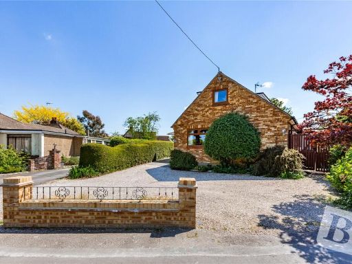 4 bedroom detached house for sale in Crow Green Road, Pilgrims Hatch, Brentwood, Essex, CM15 — £700,000 • 4 bed • 2 bath • 1855 ft²
 4 bedroom detached house for sale in Billericay Road, Brentwood, Essex, CM13 — £1,350,000 • 4 bed • 3 bath • 3377 ft²
 4 bedroom semi-detached house for sale in Crow Green Lane, Brentwood, CM15 — £575,000 • 4 bed • 2 bath • 1498 ft²
Meta
- {
"@context": "https://schema.org",
"@type": "Residence",
"name": "4 bedroom semidetached house for sale in Ongar Road, Pilgri…",
"description": "",
"url": "https://propertypiper.co.uk/property/e2198cf9-5e1f-4eca-9c2e-08c07c682329",
"image": "https://image-a.propertypiper.co.uk/d6516e7e-e914-45d0-bdf4-1d49e575b8db-1024.jpeg",
"address": {
"@type": "PostalAddress",
"streetAddress": "404 ONGAR ROAD PILGRIMS HATCH BRENTWOOD",
"postalCode": "CM15 9JN",
"addressLocality": "Brentwood",
"addressRegion": "Brentwood and Ongar",
"addressCountry": "England"
},
"geo": {
"@type": "GeoCoordinates",
"latitude": 51.63769807010326,
"longitude": 0.278706989143307
},
"numberOfRooms": 4,
"numberOfBathroomsTotal": 3,
"floorSize": {
"@type": "QuantitativeValue",
"value": 1498,
"unitCode": "FTK"
},
"offers": {
"@type": "Offer",
"price": 690000,
"priceCurrency": "GBP",
"availability": "https://schema.org/InStock"
},
"additionalProperty": [
{
"@type": "PropertyValue",
"name": "Feature",
"value": "property"
},
{
"@type": "PropertyValue",
"name": "Feature",
"value": "swimming pool"
},
{
"@type": "PropertyValue",
"name": "Feature",
"value": "outdoor"
},
{
"@type": "PropertyValue",
"name": "Feature",
"value": "modern"
},
{
"@type": "PropertyValue",
"name": "Feature",
"value": "garden"
},
{
"@type": "PropertyValue",
"name": "Feature",
"value": "landscaped"
},
{
"@type": "PropertyValue",
"name": "Feature",
"value": "patio"
},
{
"@type": "PropertyValue",
"name": "Feature",
"value": "privacy"
},
{
"@type": "PropertyValue",
"name": "Feature",
"value": "large space"
},
{
"@type": "PropertyValue",
"name": "Feature",
"value": "semi-detached"
},
{
"@type": "PropertyValue",
"name": "Feature",
"value": "residential"
},
{
"@type": "PropertyValue",
"name": "Feature",
"value": "brick exterior"
},
{
"@type": "PropertyValue",
"name": "Feature",
"value": "bay window"
},
{
"@type": "PropertyValue",
"name": "Feature",
"value": "chimney"
},
{
"@type": "PropertyValue",
"name": "Feature",
"value": "two-story"
},
{
"@type": "PropertyValue",
"name": "Feature",
"value": "suburban"
},
{
"@type": "PropertyValue",
"name": "Feature",
"value": "driveway"
},
{
"@type": "PropertyValue",
"name": "Feature",
"value": "paved parking"
},
{
"@type": "PropertyValue",
"name": "Feature",
"value": "landscaped"
},
{
"@type": "PropertyValue",
"name": "Feature",
"value": "bushes"
},
{
"@type": "PropertyValue",
"name": "Feature",
"value": "classic design"
}
]
}
High Res Floorplan Images
Compatible Floorplan Images
FloorplanImages Thumbnail