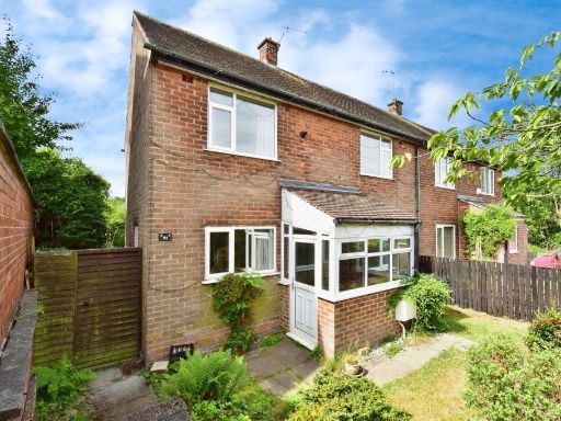
S43 3EH - 3 bedroom semidetached house for sale in 15 Clarendon Road,…
View on Property Piper
3 bedroom semi-detached house for sale in 15 Clarendon Road, Inkersall, Chesterfield S43 3EH, S43
Property Details
- Price: £90000
- Bedrooms: 3
- Bathrooms: 1
- Property Type: undefined
- Property SubType: undefined
Image Descriptions
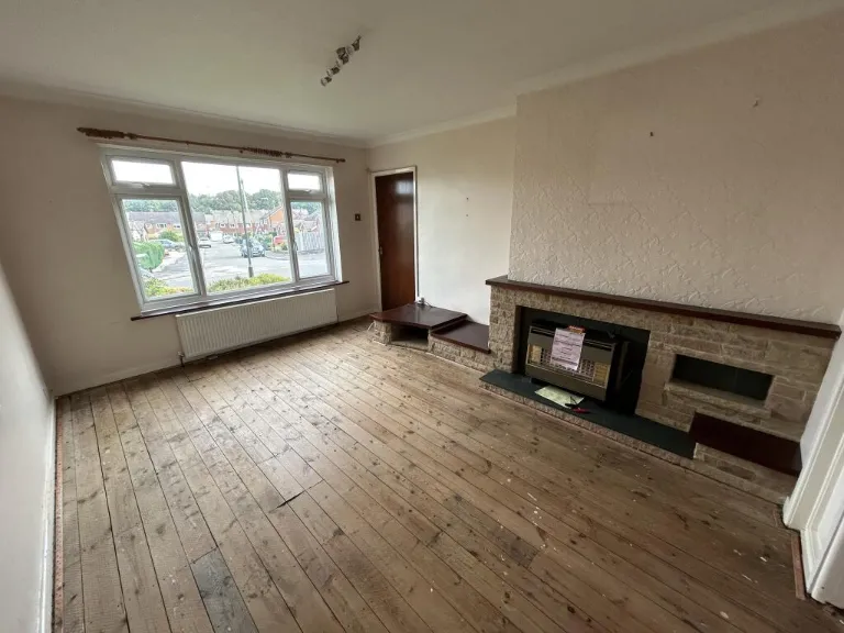
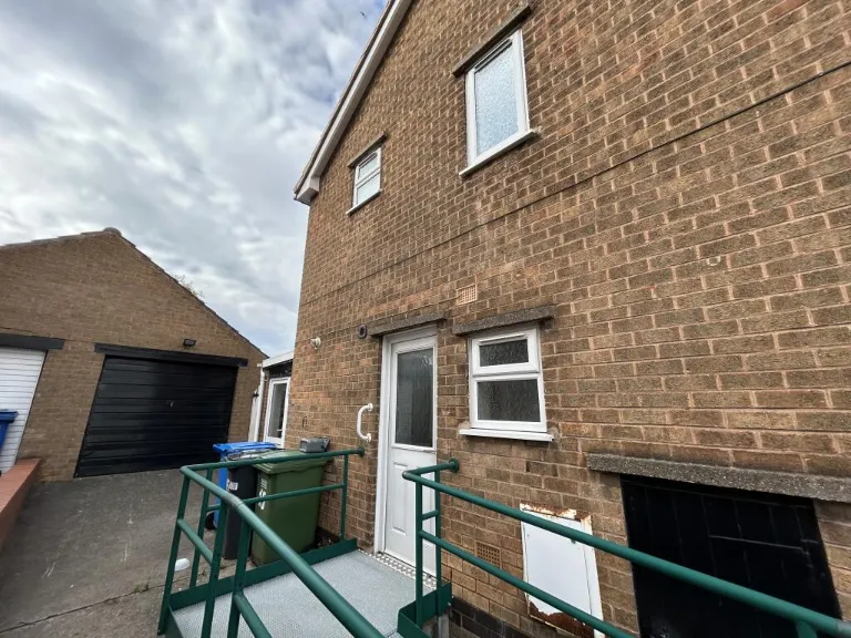
- residential property 1950s post-war semi-detached
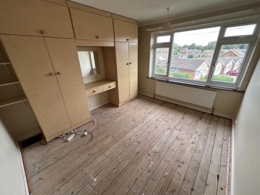
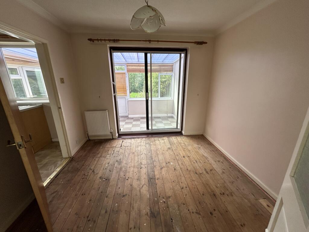
- living room mid-20th century
Rooms
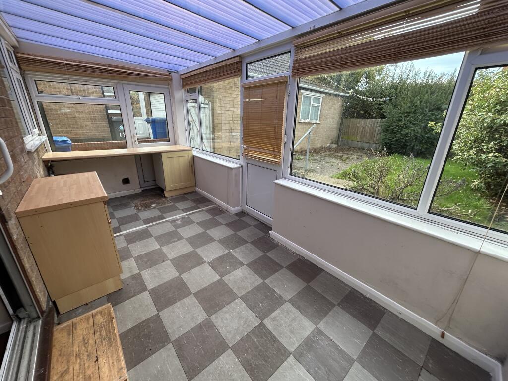
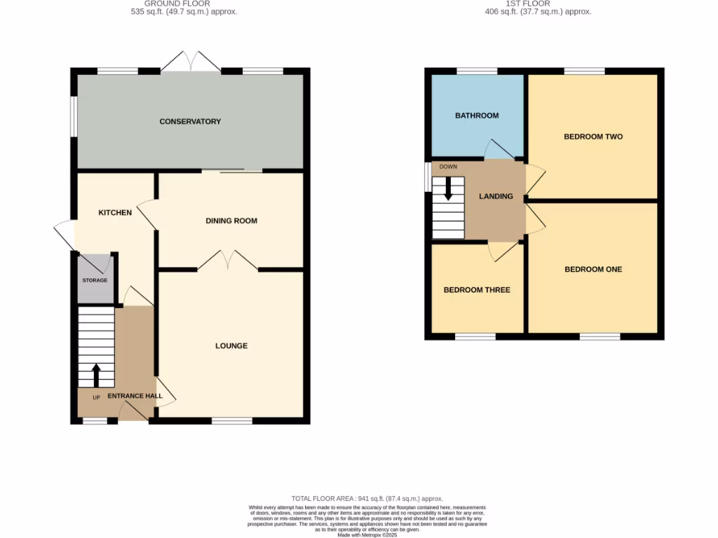
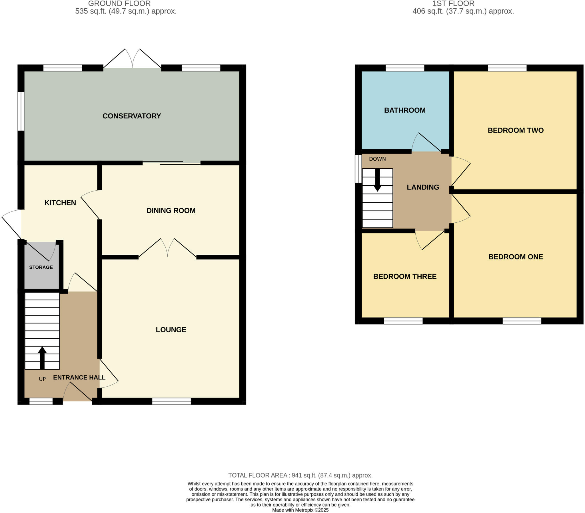
- CONSERVATORY:
- KITCHEN:
- DINING ROOM:
- LOUNGE:
- STORAGE:
- ENTRANCE HALL:
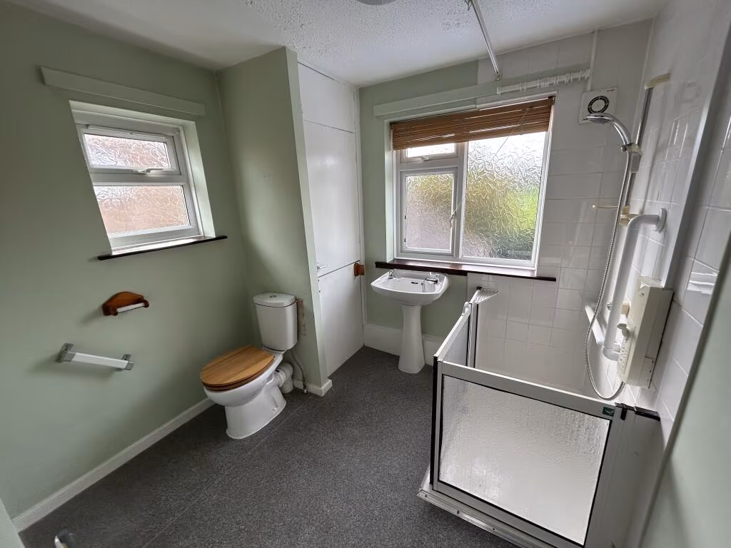
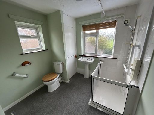
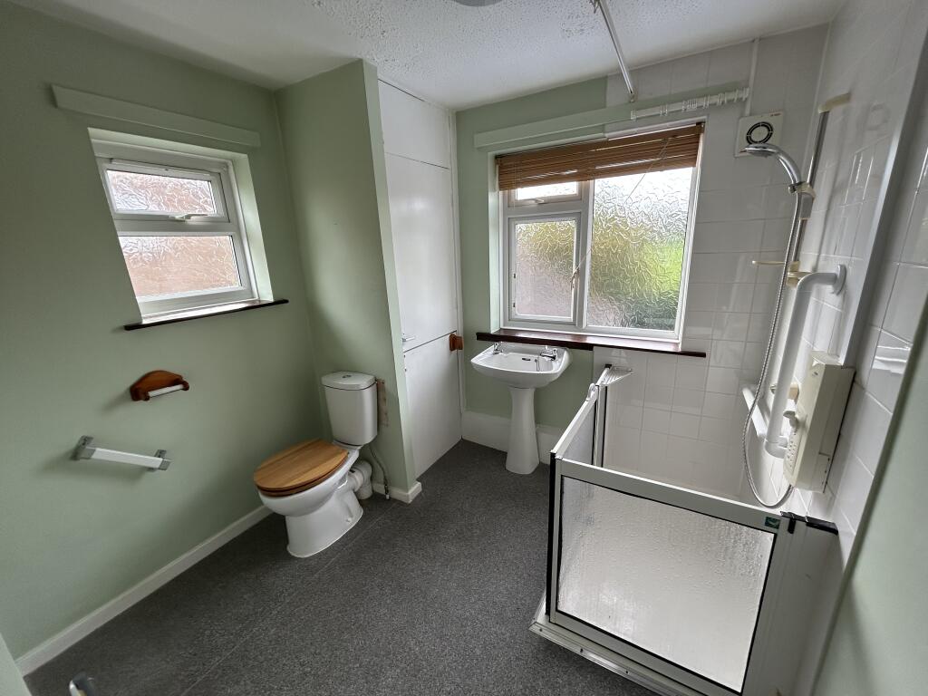
- BATHROOM:
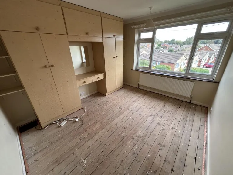
- BEDROOM TWO:
- LANDING:
- BEDROOM THREE:
- BEDROOM ONE:
Textual Property Features
- Is Auction
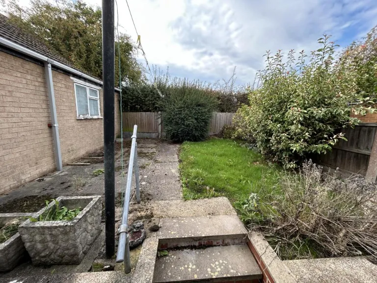
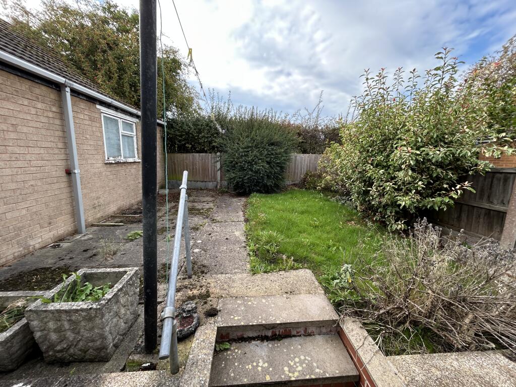
- Has Garden
- Success
Detected Visual Features
- 1950s
- post-war
- semi-detached
- brick exterior
- residential
- UK
- driveway
- ramp access
- garage
- garden
- outdoor space
- mid-20th century
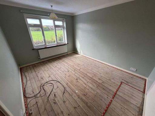
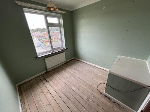
- living room
- wooden floor
- fireplace
- large window
- natural light
- unkept
- needs modernization
- dated
- untidy
EPC Details
- Fully double glazed
- Cavity wall, filled cavity
- Boiler and radiators, mains gas
- Low energy lighting in 55% of fixed outlets
- Suspended, no insulation (assumed)
Nearby Schools
- Calow CofE VC Primary School
- Duckmanton Primary School
- Springwell Community College
- St Joseph's Catholic and CofE (VA) Primary School
- St Peter and St Paul School
- Arkwright Primary School
- Henry Bradley Infant School
- Hollingwood Primary School
- Whittington Green School
- Birk Hill Infant & Nursery School
- Poolsbrook Primary Academy
- Speedwell Infant School
- Norbriggs Primary School
- New Whittington Community Primary School
- Renishaw Primary School
- Eckington School
- Temple Normanton Junior Academy
- Hasland Junior School
- Outwood Academy Hasland Hall
- Hasland Infant School
- Brimington Manor Infant and Nursery School
- Inkersall Spencer Academy
- Brimington Junior School
- Staveley Junior School
- Woodthorpe CofE Primary School
- Netherthorpe School
Nearest Bars And Restaurants
- Id: 238842706
- Tags:
- Amenity: fast_food
- Building: yes
- Name: Tasty Bites
- TagsNormalized:
- Lat: 53.2606464
- Lon: -1.3688427
- FullGeoHash: gcrnbzg1z8hg
- PartitionGeoHash: gcrn
- Images:
- FoodStandards: null
- Distance: 989.6
,- Id: 238842257
- Tags:
- Amenity: pub
- Beer_garden: yes
- Building: yes
- Name: Double Top
- Parking: yes
- Real_ale: no
- Source: View from South;Bing
- TagsNormalized:
- Lat: 53.2565601
- Lon: -1.3699867
- FullGeoHash: gcrnbz43uyrg
- PartitionGeoHash: gcrn
- Images:
- FoodStandards: null
- Distance: 581.3
,- Id: 238839348
- Tags:
- Amenity: pub
- Building: yes
- Name: Hop Flower
- Outdoor_seating: yes
- Parking: yes
- Real_ale: Abbeydale Moonshine
- Sky: yes
- TagsNormalized:
- Lat: 53.2483266
- Lon: -1.3709149
- FullGeoHash: gcrnbv99zreb
- PartitionGeoHash: gcrn
- Images:
- FoodStandards: null
- Distance: 516.1
,- Id: 2466409507
- Tags:
- Amenity: fast_food
- Cuisine: fish_and_chips
- Name: Inky Fish and Kebab Takeaway
- TagsNormalized:
- fast food
- food
- fish
- kebab
- takeaway
- Lat: 53.255465
- Lon: -1.3706756
- FullGeoHash: gcrnbycgsfnn
- PartitionGeoHash: gcrn
- Images:
- FoodStandards: null
- Distance: 503.3
,- Id: 284098109
- Tags:
- Amenity: fast_food
- Building: yes
- Cuisine: pizza;kebab
- Name: Inky Pizza
- TagsNormalized:
- Lat: 53.2487414
- Lon: -1.3712042
- FullGeoHash: gcrnbv9s2su5
- PartitionGeoHash: gcrn
- Images:
- FoodStandards: null
- Distance: 494.6
}
Nearest General Shops
- Id: 290078257
- Tags:
- Building: yes
- Car_repair: MOT
- Name: Staveley MOT Centre
- Shop: car_repair
- TagsNormalized:
- Lat: 53.2654816
- Lon: -1.357934
- FullGeoHash: gcrp10ejvv7n
- PartitionGeoHash: gcrp
- Images:
- FoodStandards: null
- Distance: 1601.2
,- Id: 284098111
- Tags:
- Building: yes
- Name: Premier Electronic Services
- Shop: computer
- TagsNormalized:
- premier
- service
- computer
- shop
- Lat: 53.2486939
- Lon: -1.3712472
- FullGeoHash: gcrnbv9kpegz
- PartitionGeoHash: gcrn
- Images:
- FoodStandards: null
- Distance: 500.4
,- Id: 579975832
- Tags:
- Fixme: Get name of fence shop
- Shop: fence
- TagsNormalized:
- Lat: 53.2511223
- Lon: -1.3689653
- FullGeoHash: gcrnby54kb9m
- PartitionGeoHash: gcrn
- Images:
- FoodStandards: null
- Distance: 216.6
}
Nearest Grocery shops
- Id: 238842258
- Tags:
- Name: Co-Op
- Shop: convenience
- Source: View from south
- TagsNormalized:
- Lat: 53.2562281
- Lon: -1.3696928
- FullGeoHash: gcrnbz485b7n
- PartitionGeoHash: gcrn
- Images:
- FoodStandards: null
- Distance: 539.5
,- Id: 2466409509
- Tags:
- Brand: Spar
- Brand:wikidata: Q610492
- Name: Spar
- Shop: convenience
- TagsNormalized:
- Lat: 53.2556673
- Lon: -1.3708124
- FullGeoHash: gcrnbycu9zbj
- PartitionGeoHash: gcrn
- Images:
- FoodStandards: null
- Distance: 526.6
,- Id: 435715510
- Tags:
- Building: yes
- Name: Select and Save
- Shop: convenience
- TagsNormalized:
- Lat: 53.2515745
- Lon: -1.3719358
- FullGeoHash: gcrnby0uzsfx
- PartitionGeoHash: gcrn
- Images:
- FoodStandards: null
- Distance: 397.4
}
Nearest Religious buildings
- Id: 240442867
- Tags:
- Amenity: place_of_worship
- Building: yes
- Denomination: methodist
- Religion: christian
- Source: View from South;Bing
- TagsNormalized:
- place of worship
- methodist
- christian
- church
- Lat: 53.2663576
- Lon: -1.3566282
- FullGeoHash: gcrp10u5h28x
- PartitionGeoHash: gcrp
- Images:
- FoodStandards: null
- Distance: 1722.7
,- Id: 240444628
- Tags:
- Amenity: place_of_worship
- Building: yes
- Denomination: roman_catholic
- Religion: christian
- Source: View from South;Bing
- TagsNormalized:
- place of worship
- catholic
- roman catholic
- christian
- church
- Lat: 53.2635668
- Lon: -1.3621984
- FullGeoHash: gcrp1024f2x2
- PartitionGeoHash: gcrp
- Images:
- FoodStandards: null
- Distance: 1320.3
,- Id: 375727347
- Tags:
- Amenity: place_of_worship
- Denomination: anglican
- Name: St Columba
- Religion: christian
- Wikidata: Q105094392
- TagsNormalized:
- place of worship
- anglican
- christian
- church
- Lat: 53.2556806
- Lon: -1.368903
- FullGeoHash: gcrnbyghy4rv
- PartitionGeoHash: gcrn
- Images:
- FoodStandards: null
- Distance: 461.7
}
Nearest Medical buildings
- Id: 4960560314
- Tags:
- Amenity: pharmacy
- Healthcare: pharmacy
- Name: Peak Pharmacy
- TagsNormalized:
- Lat: 53.2686347
- Lon: -1.3507124
- FullGeoHash: gcrp1322q15z
- PartitionGeoHash: gcrp
- Images:
- FoodStandards: null
- Distance: 2119
,- Id: 4696356703
- Tags:
- Amenity: doctors
- Healthcare: doctor
- TagsNormalized:
- doctor
- doctors
- health
- healthcare
- Lat: 53.2574344
- Lon: -1.395846
- FullGeoHash: gcrnbppx43mf
- PartitionGeoHash: gcrn
- Images:
- FoodStandards: null
- Distance: 2079
,- Id: 2411558468
- Tags:
- Leisure: sports_centre
- Name: Healthy Living Centre
- TagsNormalized:
- sports
- sports centre
- leisure
- health
- Lat: 53.2659246
- Lon: -1.3527946
- FullGeoHash: gcrp10ybt850
- PartitionGeoHash: gcrp
- Images:
- FoodStandards: null
- Distance: 1788.3
,- Id: 199560059
- Tags:
- Addr:
- City: Chesterfield
- Postcode: S43 3XR
- Street: Barlow Road
- Building: yes
- Leisure: fitness_centre
- Name: Healthy Living Centre
- Phone: +44 1246 345666
- Source: View from E;Bing
- Sport: swimming;climbing;fitness
- Website: https://www.chesterfield.gov.uk/healthylivingcentre
- TagsNormalized:
- fitness
- fitness centre
- leisure
- health
- swimming
- climbing
- sports
- Lat: 53.2657777
- Lon: -1.3528402
- FullGeoHash: gcrp10wzss9h
- PartitionGeoHash: gcrp
- Images:
- FoodStandards: null
- Distance: 1772.6
}
Nearest Leisure Facilities
- Id: 972235115
- Tags:
- Leisure: playground
- Surface: concrete
- TagsNormalized:
- Lat: 53.2568246
- Lon: -1.365895
- FullGeoHash: gcrnbzj7krdv
- PartitionGeoHash: gcrn
- Images:
- FoodStandards: null
- Distance: 546.3
,- Id: 375725367
- Tags:
- Fixme: sport=? soccer? rugby? field_hockey?
- Leisure: pitch
- Source: View from road;Bing
- Sport: football
- TagsNormalized:
- pitch
- leisure
- football
- sports
- Lat: 53.2527152
- Lon: -1.3675156
- FullGeoHash: gcrnbyk5w9d7
- PartitionGeoHash: gcrn
- Images:
- FoodStandards: null
- Distance: 135.3
,- Id: 375724898
- Tags:
- Leisure: playground
- Source: View from south;Bing
- TagsNormalized:
- Lat: 53.2511707
- Lon: -1.3675214
- FullGeoHash: gcrnbyh4w3wn
- PartitionGeoHash: gcrn
- Images:
- FoodStandards: null
- Distance: 131.1
,- Id: 375725368
- Tags:
- Fixme: sport=? soccer? rugby? field_hockey?
- Leisure: pitch
- Source: View from road;Bing
- Sport: football
- TagsNormalized:
- pitch
- leisure
- football
- sports
- Lat: 53.2520379
- Lon: -1.3674311
- FullGeoHash: gcrnbyhr8e37
- PartitionGeoHash: gcrn
- Images:
- FoodStandards: null
- Distance: 97
,- Id: 375725364
- Tags:
- Fixme: sport=? soccer? rugby? field_hockey?
- Leisure: pitch
- Source: View from road;Bing
- Sport: football
- TagsNormalized:
- pitch
- leisure
- football
- sports
- Lat: 53.2520495
- Lon: -1.3669463
- FullGeoHash: gcrnbyhxevdb
- PartitionGeoHash: gcrn
- Images:
- FoodStandards: null
- Distance: 65.5
}
Nearest Tourist attractions
- Id: 290076469
- Tags:
- Building: yes
- Name: Old Rectory
- Tourism: guest_house
- TagsNormalized:
- Lat: 53.2685977
- Lon: -1.3510685
- FullGeoHash: gcrp1320jf66
- PartitionGeoHash: gcrp
- Images:
- FoodStandards: null
- Distance: 2104.1
,- Id: 500901607
- Tags:
- TagsNormalized:
- Lat: 53.2581482
- Lon: -1.3487078
- FullGeoHash: gcrncr3ghy6s
- PartitionGeoHash: gcrn
- Images:
- FoodStandards: null
- Distance: 1342.5
,- Id: 334906294
- Tags:
- Name: Caravan Club Site - Poolsbrook
- Tourism: caravan_site
- TagsNormalized:
- Lat: 53.2579073
- Lon: -1.3521056
- FullGeoHash: gcrncpr3v9kz
- PartitionGeoHash: gcrn
- Images:
- FoodStandards: null
- Distance: 1139
}
Nearest Train stations
- Id: 3170172463
- Tags:
- Name: Creswell
- Naptan:
- Network: National Rail
- Public_transport: station
- Railway: station
- Ref:
- Source: NPE
- Train: yes
- Wikidata: Q1967041
- Wikipedia: en:Creswell railway station
- TagsNormalized:
- Lat: 53.263919
- Lon: -1.2164106
- FullGeoHash: gcrph26hzd4t
- PartitionGeoHash: gcrp
- Images:
- FoodStandards: null
- Distance: 10038.9
,- Id: 370186628
- Tags:
- Name: Dronfield
- Naptan:
- Network: National Rail
- Platforms: 2
- Public_transport: station
- Railway: station
- Ref:
- Wikidata: Q2161199
- Wikipedia: en:Dronfield railway station
- TagsNormalized:
- Lat: 53.3014
- Lon: -1.4692529
- FullGeoHash: gcqznx4p5vje
- PartitionGeoHash: gcqz
- Images:
- FoodStandards: null
- Distance: 8799
,- Id: 7154300845
- Tags:
- Name: Chesterfield
- Naptan:
- Network: National Rail
- Public_transport: station
- Railway: station
- Ref:
- Wikidata: Q2645921
- Wikipedia: en:Chesterfield railway station
- TagsNormalized:
- Lat: 53.2382236
- Lon: -1.4197283
- FullGeoHash: gcqyzewpjujv
- PartitionGeoHash: gcqy
- Images:
- FoodStandards: null
- Distance: 3886.2
,- Id: 1716256015
- Tags:
- Name: Roundhouse Halt
- Public_transport: station
- Railway: station
- Usage: tourism
- Website: https://www.barrowhill.org/
- TagsNormalized:
- Lat: 53.2746594
- Lon: -1.3813376
- FullGeoHash: gcrp0d65ks21
- PartitionGeoHash: gcrp
- Images:
- FoodStandards: null
- Distance: 2727.6
,- Id: 102031003
- Tags:
- Building: train_station
- Name: Barrow Hill Roundhouse
- Railway: turntable
- Tourism: attraction
- Wikidata: Q4863884
- Wikipedia: en:Barrow Hill Engine Shed
- TagsNormalized:
- station
- train
- train station
- railway
- attraction
- tourism
- Lat: 53.2744292
- Lon: -1.381839
- FullGeoHash: gcrp0d3f0c6h
- PartitionGeoHash: gcrp
- Images:
- FoodStandards: null
- Distance: 2716.7
}
Nearest Bus stations and stops
- Id: 505824384
- Tags:
- Bus: yes
- Ele: 105.8701172
- Highway: bus_stop
- Public_transport: platform
- TagsNormalized:
- Lat: 53.2469057
- Lon: -1.3743453
- FullGeoHash: gcrnbtr1xqtu
- PartitionGeoHash: gcrn
- Images:
- FoodStandards: null
- Distance: 786.7
,- Id: 3070841962
- Tags:
- Bus: yes
- Highway: bus_stop
- Public_transport: platform
- TagsNormalized:
- Lat: 53.2457774
- Lon: -1.3714043
- FullGeoHash: gcrnbv175uqf
- PartitionGeoHash: gcrn
- Images:
- FoodStandards: null
- Distance: 771.4
,- Id: 711044668
- Tags:
- Bus: yes
- Ele: 99.6215820
- Highway: bus_stop
- Public_transport: platform
- TagsNormalized:
- Lat: 53.2518049
- Lon: -1.3724093
- FullGeoHash: gcrnby0whxcm
- PartitionGeoHash: gcrn
- Images:
- FoodStandards: null
- Distance: 427.3
,- Id: 1643009699
- Tags:
- Bus: yes
- Highway: bus_stop
- Public_transport: platform
- TagsNormalized:
- Lat: 53.2502301
- Lon: -1.3664957
- FullGeoHash: gcrnbvuvn66g
- PartitionGeoHash: gcrn
- Images:
- FoodStandards: null
- Distance: 190
,- Id: 2095640231
- Tags:
- Bus: yes
- Highway: bus_stop
- Public_transport: platform
- TagsNormalized:
- Lat: 53.2504401
- Lon: -1.3653754
- FullGeoHash: gcrnbvvy23w2
- PartitionGeoHash: gcrn
- Images:
- FoodStandards: null
- Distance: 168.7
}
Nearest Hotels
- Id: 51461739
- Tags:
- TagsNormalized:
- Lat: 53.2505926
- Lon: -1.4243823
- FullGeoHash: gcqyztfz1mzt
- PartitionGeoHash: gcqy
- Images:
- FoodStandards: null
- Distance: 3887.6
,- Id: 376741854
- Tags:
- Addr:
- City: Chesterfield
- Postcode: S41 7NJ
- Street: Tapton Lock Hill
- Brand: Premier Inn
- Brand:wikidata: Q2108626
- Brand:wikipedia: en:Premier Inn
- Building: hotel
- Internet_access: wlan
- Internet_access:fee: customers
- Internet_access:operator: Virgin Media
- Internet_access:ssid: Premier Inn Free Wi-Fi
- Name: Premier Inn Chesterfield North
- Operator: Premier Inn
- Tourism: hotel
- TagsNormalized:
- Lat: 53.2506582
- Lon: -1.419783
- FullGeoHash: gcqyztypsdjj
- PartitionGeoHash: gcqy
- Images:
- FoodStandards: null
- Distance: 3581.6
,- Id: 1064669051
- Tags:
- Internet_access: wlan
- Internet_access:fee: no
- Name: Ringwood Hall Hotel
- Phone: +44 1246 280077
- Stars: 3
- Tourism: hotel
- Website: https://www.ringwoodhallhotel.com/
- TagsNormalized:
- Lat: 53.2587256
- Lon: -1.3822138
- FullGeoHash: gcrnbx3w8449
- PartitionGeoHash: gcrn
- Images:
- FoodStandards: null
- Distance: 1318.7
}
Tags
- 1950s
- post-war
- semi-detached
- brick exterior
- residential
- UK
- driveway
- ramp access
- garage
- garden
- outdoor space
- mid-20th century
- living room
- wooden floor
- fireplace
- large window
- natural light
- unkept
- needs modernization
- dated
- untidy
Local Market Stats
- Average Price/sqft: £204
- Avg Income: £35600
- Rental Yield: 4.2%
- Social Housing: 15%
- Planning Success Rate: 97%
Similar Properties
 3 bedroom semi-detached house for sale in Dade Avenue, Inkersall, Chesterfield, S43 — £150,000 • 3 bed • 1 bath • 642 ft²
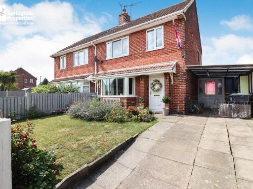 3 bedroom semi-detached house for sale in Curbar Curve, Inkersall, Derbyshire, S43 — £200,000 • 3 bed • 1 bath • 960 ft²
 3 bedroom semi-detached house for sale in Middleton Drive, Inkersall, Chesterfield, S43 — £180,000 • 3 bed • 1 bath • 872 ft²
 3 bedroom semi-detached house for sale in Turner Drive, Inkersall, S43 — £230,000 • 3 bed • 1 bath • 1055 ft²
 3 bedroom semi-detached house for sale in 66 Cornwall Drive, Brimington, Chesterfield, Derbyshire, S43 1EF, S43 — £29,000 • 3 bed • 1 bath
 3 bedroom semi-detached house for sale in Hillman Drive, Inkersall, Chesterfield, Derbyshire, S43 — £185,000 • 3 bed • 2 bath • 1055 ft²
Meta
- {
"@context": "https://schema.org",
"@type": "Residence",
"name": "3 bedroom semidetached house for sale in 15 Clarendon Road,…",
"description": "",
"url": "https://propertypiper.co.uk/property/dae0bd5e-7839-42b1-ac08-10ecd42dc6a6",
"image": "https://image-a.propertypiper.co.uk/4adc8212-bf31-4599-81a6-2eeea74ad918-1024.jpeg",
"address": {
"@type": "PostalAddress",
"streetAddress": "15, Clarendon Road, Inkersall",
"postalCode": "S43 3EH",
"addressLocality": "Chesterfield",
"addressRegion": "Chesterfield",
"addressCountry": "England"
},
"geo": {
"@type": "GeoCoordinates",
"latitude": 53.25191187459848,
"longitude": -1.365988957528237
},
"numberOfRooms": 3,
"numberOfBathroomsTotal": 1,
"floorSize": {
"@type": "QuantitativeValue",
"value": 941,
"unitCode": "FTK"
},
"offers": {
"@type": "Offer",
"price": 90000,
"priceCurrency": "GBP",
"availability": "https://schema.org/InStock"
},
"additionalProperty": [
{
"@type": "PropertyValue",
"name": "Feature",
"value": "1950s"
},
{
"@type": "PropertyValue",
"name": "Feature",
"value": "post-war"
},
{
"@type": "PropertyValue",
"name": "Feature",
"value": "semi-detached"
},
{
"@type": "PropertyValue",
"name": "Feature",
"value": "brick exterior"
},
{
"@type": "PropertyValue",
"name": "Feature",
"value": "residential"
},
{
"@type": "PropertyValue",
"name": "Feature",
"value": "UK"
},
{
"@type": "PropertyValue",
"name": "Feature",
"value": "driveway"
},
{
"@type": "PropertyValue",
"name": "Feature",
"value": "ramp access"
},
{
"@type": "PropertyValue",
"name": "Feature",
"value": "garage"
},
{
"@type": "PropertyValue",
"name": "Feature",
"value": "garden"
},
{
"@type": "PropertyValue",
"name": "Feature",
"value": "outdoor space"
},
{
"@type": "PropertyValue",
"name": "Feature",
"value": "mid-20th century"
},
{
"@type": "PropertyValue",
"name": "Feature",
"value": "living room"
},
{
"@type": "PropertyValue",
"name": "Feature",
"value": "wooden floor"
},
{
"@type": "PropertyValue",
"name": "Feature",
"value": "fireplace"
},
{
"@type": "PropertyValue",
"name": "Feature",
"value": "large window"
},
{
"@type": "PropertyValue",
"name": "Feature",
"value": "natural light"
},
{
"@type": "PropertyValue",
"name": "Feature",
"value": "unkept"
},
{
"@type": "PropertyValue",
"name": "Feature",
"value": "needs modernization"
},
{
"@type": "PropertyValue",
"name": "Feature",
"value": "dated"
},
{
"@type": "PropertyValue",
"name": "Feature",
"value": "untidy"
}
]
}
High Res Floorplan Images
Compatible Floorplan Images
FloorplanImages Thumbnail