SM6 9JR - 3 bedroom maisonette for sale in Brackley Close, Wallington…
View on Property Piper
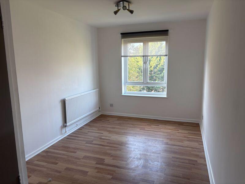
3 bedroom maisonette for sale in Brackley Close, Wallington, SM6
Property Details
- Price: £349950
- Bedrooms: 3
- Bathrooms: 1
- Property Type: undefined
- Property SubType: undefined
Image Descriptions
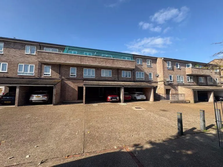
- apartment complex 1970s
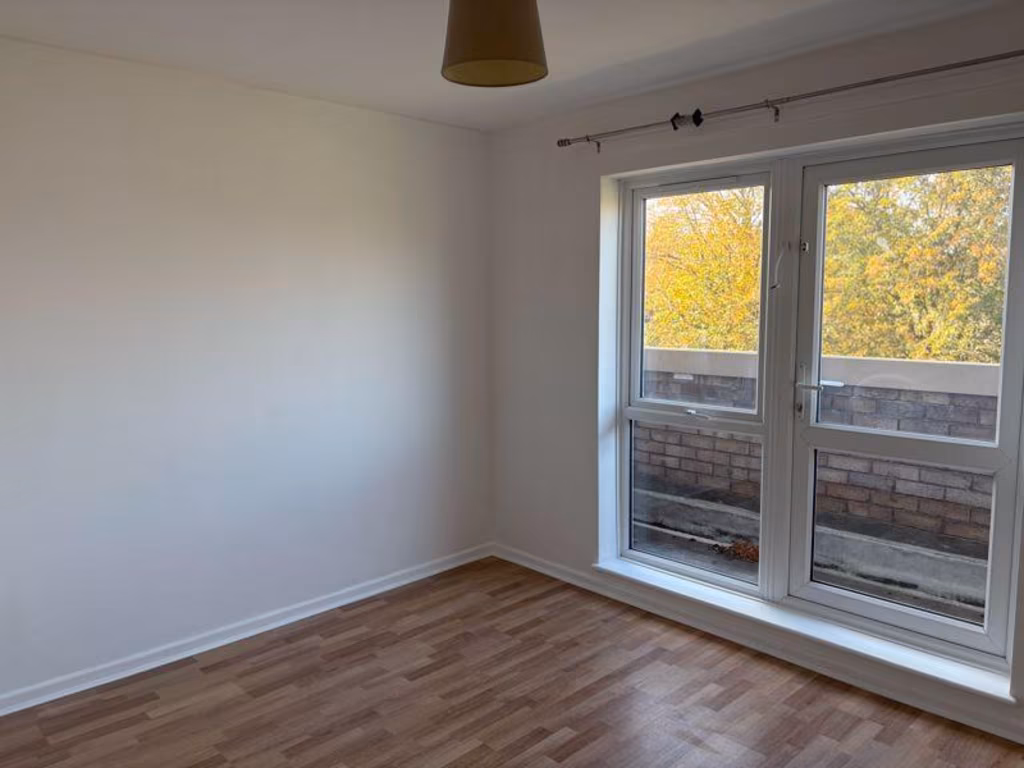
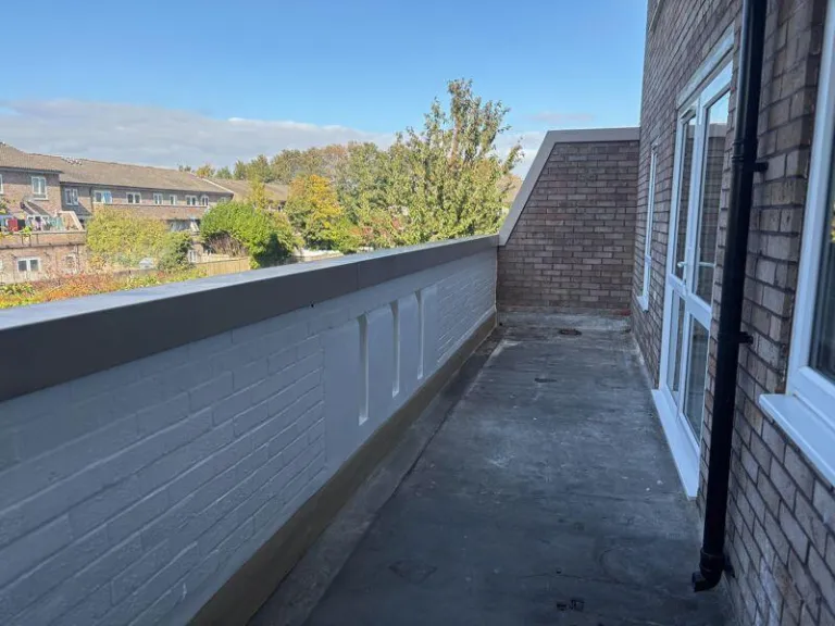
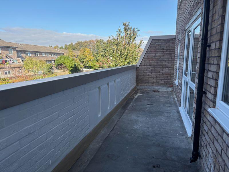
- balcony Modern
Rooms
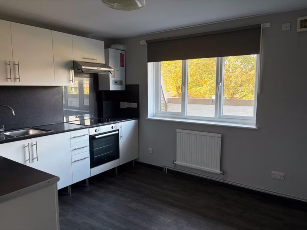
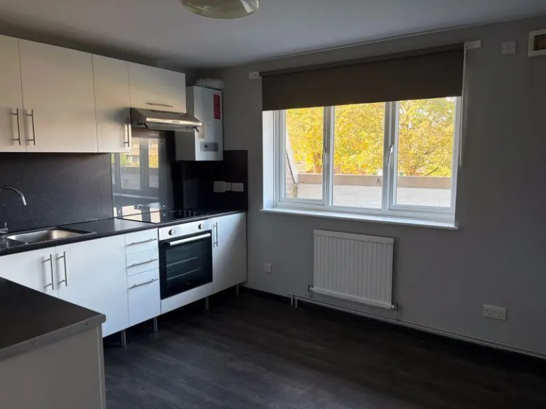
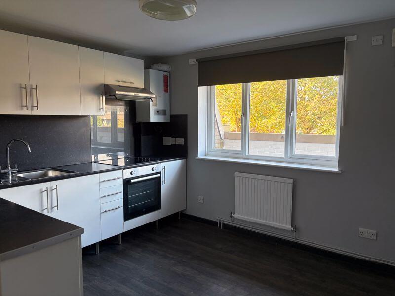
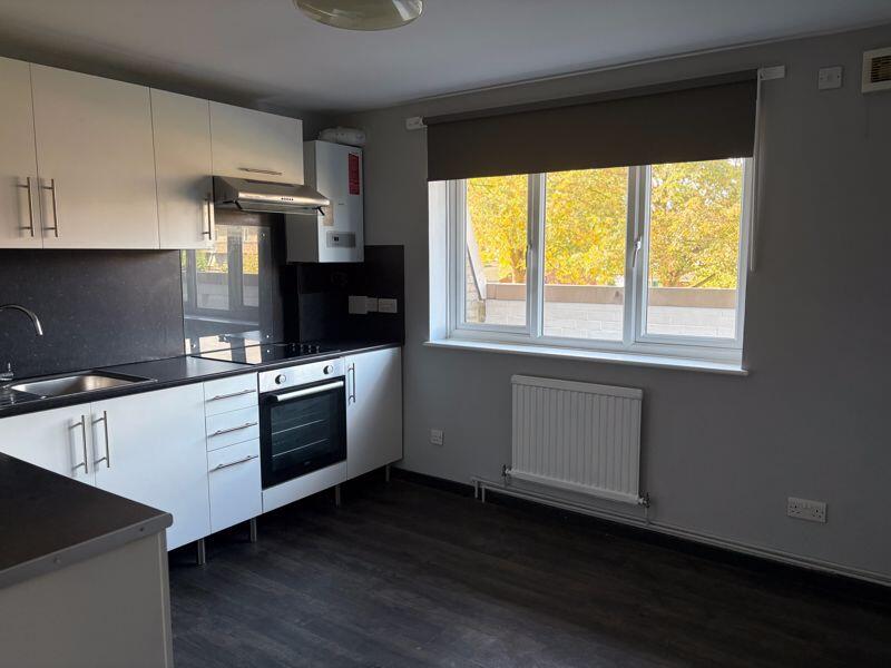
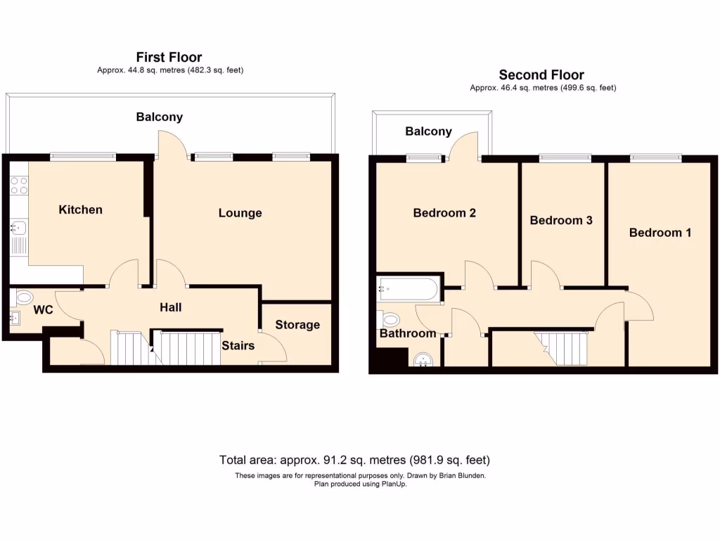
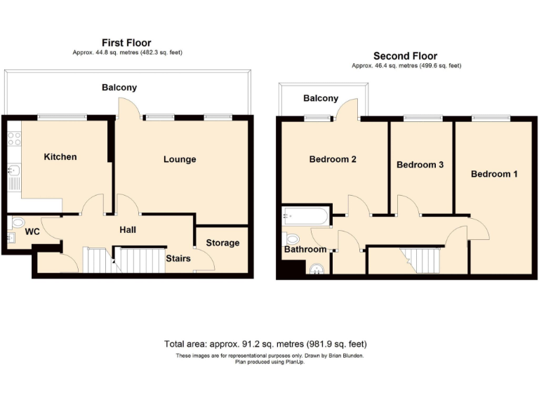
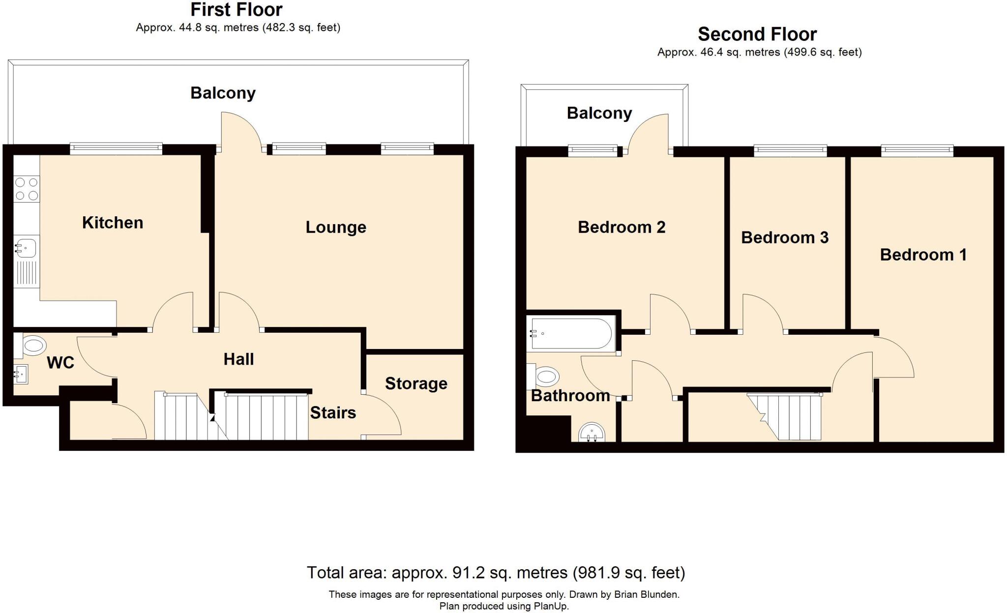
- Kitchen:
- Lounge:
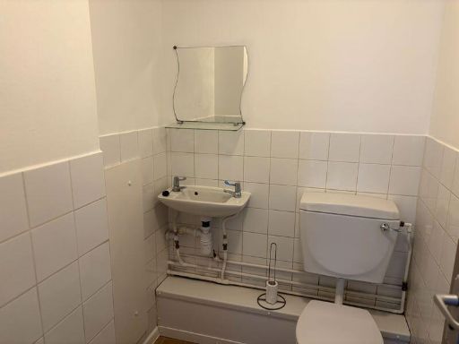
- WC:
- Hall:
- Storage:
- Stairs:
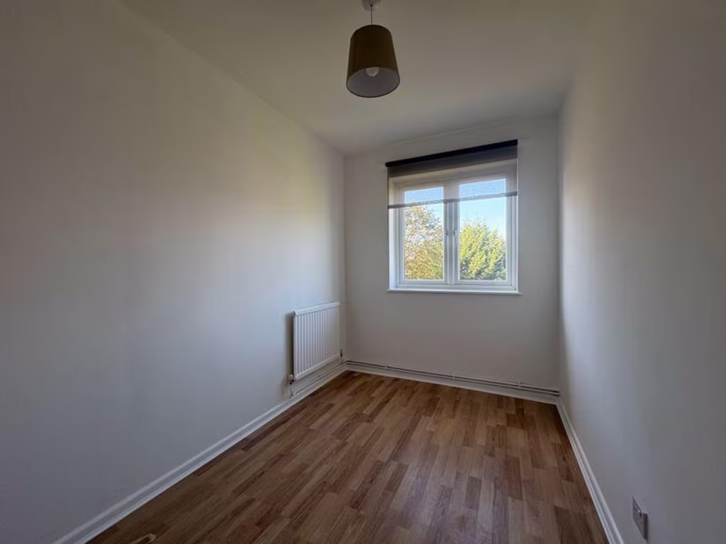
- Bedroom 2:
- Bedroom 3:
- Bedroom 1:
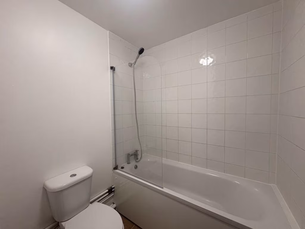
- Bathroom:
- Stairs:
Textual Property Features
Detected Visual Features
- 1970s
- apartment complex
- brick facade
- parking area
- suburban
- attached carport
- balcony
- modern
- brickwork
- concrete flooring
- outdoor space
- unmaintained
- exterior walls
- residential area
- fixer-upper
EPC Details
- Single glazed
- Cavity wall, filled cavity
- Boiler and radiators, mains gas
- Low energy lighting in all fixed outlets
- (another dwelling below)
Nearby Schools
- Christ Church CofE Primary School (Purley)
- Thomas More Catholic School
- Laleham Lea School
- The John Fisher School
- Bandon Hill Primary School
- Wilson's School
- Cumnor House School
- Wallington Primary Academy
- Harris Academy Purley
- Foresters Primary School
- Harris Primary Academy Purley Way
- Holy Trinity CofE Junior School
- Beddington Park Academy
- St David's School
- Regina Coeli Catholic Primary School
- Aerodrome Primary Academy
- Collingwood School
- Beddington Infants' School
- Cumnor House School
- Margaret Roper Catholic Primary School
- Wallington High School for Girls
- St Elphege's RC Junior School
- St Elphege's RC Infants' School
- High View Primary School
- Wallington County Grammar School
- The Minster Nursery and Infants Church of England Academy
Nearest General Shops
- Id: 713067702
- Tags:
- Brand: Selco Builders Warehouse
- Brand:wikidata: Q112689068
- Building: yes
- Name: Selco Builders Warehouse
- Shop: trade
- Trade: building_supplies
- TagsNormalized:
- Lat: 51.3540176
- Lon: -0.1195763
- FullGeoHash: gcpujk8yvdtr
- PartitionGeoHash: gcpu
- Images:
- FoodStandards: null
- Distance: 736.7
,- Id: 181830563
- Tags:
- Brand: Toyota
- Brand:wikidata: Q53268
- Brand:wikipedia: en:Toyota
- Building: yes
- Name: Toyota Jemca
- Shop: car
- Source: Bing
- TagsNormalized:
- Lat: 51.3577499
- Lon: -0.1206246
- FullGeoHash: gcpujm2ht4rz
- PartitionGeoHash: gcpu
- Images:
- FoodStandards: null
- Distance: 701
,- Id: 6499880024
- Tags:
- Addr:
- City: Wallington
- Housenumber: 275
- Postcode: SM6 9BX
- Street: Stafford Road
- Fhrs:
- Authority: Sutton
- Id: 741485
- Name: Mellows Newsmart
- Shop: newsagent
- Source: survey;https://ratings.food.gov.uk/OpenDataFiles/FHRS529en-GB.xml
- TagsNormalized:
- Lat: 51.3601176
- Lon: -0.1306929
- FullGeoHash: gcpujjbf6eu7
- PartitionGeoHash: gcpu
- Images:
- FoodStandards:
- Id: 741485
- FHRSID: 741485
- LocalAuthorityBusinessID: 15/00038/COM
- BusinessName: Mellows Newsmart
- BusinessType: Retailers - other
- BusinessTypeID: 4613
- AddressLine1: 275 Stafford Road
- AddressLine2: Wallington
- AddressLine3: null
- AddressLine4: null
- PostCode: SM6 9BX
- RatingValue: 5
- RatingKey: fhrs_5_en-GB
- RatingDate: 2021-06-09
- LocalAuthorityCode: 529
- LocalAuthorityName: Sutton
- LocalAuthorityWebSite: http://www.sutton.gov.uk
- LocalAuthorityEmailAddress: food.safety@sutton.gov.uk
- Scores:
- Hygiene: 5
- Structural: 5
- ConfidenceInManagement: 0
- NewRatingPending: false
- Geocode:
- Longitude: -0.13203100000000
- Latitude: 51.35995200000000
- Distance: 531.5
}
Nearest Grocery shops
- Id: 614091571
- Tags:
- Addr:
- City: Wallington
- Housenumber: 133
- Postcode: SM6 9BN
- Street: Stafford Road
- Building: retail
- Name: Robins Food & Wine
- Shop: convenience
- TagsNormalized:
- retail
- food
- wine
- convenience
- shop
- Lat: 51.3591405
- Lon: -0.1407093
- FullGeoHash: gcpuhv9s9jxw
- PartitionGeoHash: gcpu
- Images:
- FoodStandards: null
- Distance: 856.3
,- Id: 5808978090
- Tags:
- Addr:
- City: Wallington
- Housenumber: 146
- Postcode: SM6 9BS
- Street: Stafford Road
- Fhrs:
- Authority: Sutton
- Id: 898433
- Name: The Connoisseur
- Shop: convenience
- TagsNormalized:
- Lat: 51.3596092
- Lon: -0.1393153
- FullGeoHash: gcpuhvdx3tnf
- PartitionGeoHash: gcpu
- Images:
- FoodStandards:
- Id: 898433
- FHRSID: 898433
- LocalAuthorityBusinessID: 04703/0146/0/000
- BusinessName: The Connoisseur
- BusinessType: Retailers - other
- BusinessTypeID: 4613
- AddressLine1: 146 Stafford Road
- AddressLine2: Wallington
- AddressLine3: null
- AddressLine4: null
- PostCode: SM6 9BS
- RatingValue: 4
- RatingKey: fhrs_4_en-GB
- RatingDate: 2020-03-02
- LocalAuthorityCode: 529
- LocalAuthorityName: Sutton
- LocalAuthorityWebSite: http://www.sutton.gov.uk
- LocalAuthorityEmailAddress: food.safety@sutton.gov.uk
- Scores:
- Hygiene: 0
- Structural: 0
- ConfidenceInManagement: 10
- NewRatingPending: false
- Geocode:
- Longitude: -0.13905200362205
- Latitude: 51.35968780517580
- Distance: 803
,- Id: 5808978098
- Tags:
- Addr:
- City: Wallington
- Housenumber: 189
- Postcode: SM6 9BT
- Street: Stafford Road
- Name: Lucky Food & Wine
- Shop: convenience
- TagsNormalized:
- Lat: 51.3593914
- Lon: -0.1381512
- FullGeoHash: gcpuhveqhu6z
- PartitionGeoHash: gcpu
- Images:
- FoodStandards: null
- Distance: 723.9
}
Nearest Religious buildings
- Id: 196086880
- Tags:
- Amenity: place_of_worship
- Created_by: JOSM
- Denomination: methodist
- Name: Bandon Hill Methodist Church
- Religion: christian
- TagsNormalized:
- place of worship
- methodist
- church
- christian
- Lat: 51.3612903
- Lon: -0.1366176
- FullGeoHash: gcpuhyh90w6w
- PartitionGeoHash: gcpu
- Images:
- FoodStandards: null
- Distance: 805.2
,- Id: 195919215
- Tags:
- Amenity: place_of_worship
- Created_by: JOSM
- Name: Wallington Christian Centre
- Religion: christian
- TagsNormalized:
- place of worship
- christian
- church
- Lat: 51.3615251
- Lon: -0.130809
- FullGeoHash: gcpujn0dxfjx
- PartitionGeoHash: gcpu
- Images:
- FoodStandards: null
- Distance: 688.1
,- Id: 174128373
- Tags:
- Addr:
- City: Wallington
- Postcode: SM6 9HG
- Street: Mollison Drive
- Amenity: place_of_worship
- Building: church
- Denomination: anglican
- Fhrs:
- Authority: Sutton
- Id: 570923
- Name: St. Paul's
- Religion: christian
- Wikidata: Q105076651
- TagsNormalized:
- place of worship
- church
- anglican
- christian
- Lat: 51.3531389
- Lon: -0.1340203
- FullGeoHash: gcpuhuw3tngj
- PartitionGeoHash: gcpu
- Images:
- FoodStandards:
- Id: 570923
- FHRSID: 570923
- LocalAuthorityBusinessID: 05/00069/COM
- BusinessName: Age Concern And St Paul's Lunch Club
- BusinessType: Restaurant/Cafe/Canteen
- BusinessTypeID: 1
- AddressLine1: St Pauls Ecumenical Church
- AddressLine2: Mollison Drive
- AddressLine3: Wallington
- AddressLine4: null
- PostCode: SM6 9HG
- RatingValue: 4
- RatingKey: fhrs_4_en-GB
- RatingDate: 2021-11-01
- LocalAuthorityCode: 529
- LocalAuthorityName: Sutton
- LocalAuthorityWebSite: http://www.sutton.gov.uk
- LocalAuthorityEmailAddress: food.safety@sutton.gov.uk
- Scores:
- Hygiene: 0
- Structural: 10
- ConfidenceInManagement: 10
- NewRatingPending: false
- Geocode:
- Longitude: -0.13406200000000
- Latitude: 51.35310500000000
- Distance: 374.5
}
Nearest Medical buildings
- Id: 22376813
- Tags:
- Leisure: sports_centre
- Name: Surrey Health & Racquets Club
- TagsNormalized:
- sports
- sports centre
- leisure
- health
- club
- Lat: 51.3568566
- Lon: -0.1220368
- FullGeoHash: gcpujjppk7fy
- PartitionGeoHash: gcpu
- Images:
- FoodStandards: null
- Distance: 575.2
,- Id: 248042438
- Tags:
- Addr:
- City: Wallington
- Housenumber: 4
- Postcode: SM6 9DA
- Street: Mollison Square
- Amenity: pharmacy
- Dispensing: yes
- Name: Day Lewis Pharmacy
- TagsNormalized:
- pharmacy
- day lewis pharmacy
- Lat: 51.3534016
- Lon: -0.1340619
- FullGeoHash: gcpuhuw7hpuh
- PartitionGeoHash: gcpu
- Images:
- FoodStandards: null
- Distance: 358.2
,- Id: 248042439
- Tags:
- Addr:
- City: Wallington
- Housenumber: 6
- Postcode: SM6 9DW
- Street: Mollison Square
- Amenity: doctors
- Name: Manor Practice
- Phone: +44 20 8647 1818
- Website: http://www.manorpractice.org.uk/
- TagsNormalized:
- Lat: 51.3533719
- Lon: -0.1336673
- FullGeoHash: gcpuhuwej667
- PartitionGeoHash: gcpu
- Images:
- FoodStandards: null
- Distance: 339
,- Id: 247806030
- Tags:
- Amenity: doctors
- Name: Wallington Medical Centre
- TagsNormalized:
- Lat: 51.3569878
- Lon: -0.1287623
- FullGeoHash: gcpujj60ps7v
- PartitionGeoHash: gcpu
- Images:
- FoodStandards: null
- Distance: 199.4
}
Nearest Airports
- Id: 260720166
- Tags:
- Aerodrome: international
- Aeroway: aerodrome
- Alt_name: Gatwick Airport
- Ele: 62
- Iata: LGW
- Icao: EGKK
- Internet_access: wlan
- Internet_access:fee: no
- Internet_access:ssid: Gatwick FREE Wi-Fi
- Name: London Gatwick Airport
- Operator: Gatwick Airport Limited
- Ref: LGW
- Website: https://www.gatwickairport.com/
- Wikidata: Q8703
- Wikipedia: en:Gatwick Airport
- TagsNormalized:
- airport
- international airport
- Lat: 51.1540917
- Lon: -0.1883773
- FullGeoHash: gcpg58qf4mzd
- PartitionGeoHash: gcpg
- Images:
- FoodStandards: null
- Distance: 22746.1
,- Id: 121158889
- Tags:
- Aerodrome: continental
- Aeroway: aerodrome
- Fhrs:
- Authority: City of London Corporation
- Iata: LCY
- Icao: EGLC
- Name: London City Airport
- Operator: London City Airport Limited
- Ref: LCY
- Website: https://www.londoncityairport.com/
- Wikidata: Q8982
- Wikipedia: en:London City Airport
- TagsNormalized:
- airport
- continental airport
- Lat: 51.5042658
- Lon: 0.0539987
- FullGeoHash: u10j10p64702
- PartitionGeoHash: u10j
- Images:
- FoodStandards: null
- Distance: 20900
,- Id: 14001268
- Tags:
- Access: yes
- Aerodrome: international
- Aerodrome:type: public
- Aeroway: aerodrome
- Alt_name: London Heathrow
- Alt_name_2: London Heathrow Airport
- Ele: 25
- Iata: LHR
- Icao: EGLL
- Int_name: Heathrow Airport
- Name: London Heathrow Airport
- Note: area still approx
- Old_name: London Airport
- Operator: Heathrow Airport Limited
- Rank_aci:
- Ref: LHR
- Short_name: Heathrow
- Type: multipolygon
- Website: https://www.heathrow.com/
- Wikidata: Q8691
- Wikipedia: en:Heathrow Airport
- TagsNormalized:
- airport
- international airport
- Lat: 51.4677522
- Lon: -0.4547736
- FullGeoHash: gcpsv9kv7h2h
- PartitionGeoHash: gcps
- Images:
- FoodStandards: null
- Distance: 25761.4
}
Nearest Leisure Facilities
- Id: 908704958
- Tags:
- Leisure: pitch
- Sport: soccer
- TagsNormalized:
- Lat: 51.3573815
- Lon: -0.1301082
- FullGeoHash: gcpujj362mb3
- PartitionGeoHash: gcpu
- Images:
- FoodStandards: null
- Distance: 225.1
,- Id: 22987518
- Tags:
- TagsNormalized:
- Lat: 51.3553258
- Lon: -0.1275739
- FullGeoHash: gcpujhgn7qd5
- PartitionGeoHash: gcpu
- Images:
- FoodStandards: null
- Distance: 166.1
,- Id: 908564904
- Tags:
- Leisure: pitch
- Sport: bowls
- TagsNormalized:
- Lat: 51.3566534
- Lon: -0.1299617
- FullGeoHash: gcpujj1q5wjd
- PartitionGeoHash: gcpu
- Images:
- FoodStandards: null
- Distance: 143.9
,- Id: 22987556
- Tags:
- Created_by: JOSM
- Leisure: playground
- TagsNormalized:
- Lat: 51.3557783
- Lon: -0.1311901
- FullGeoHash: gcpujj03p4cw
- PartitionGeoHash: gcpu
- Images:
- FoodStandards: null
- Distance: 97
,- Id: 22987502
- Tags:
- Created_by: JOSM
- Leisure: playground
- TagsNormalized:
- Lat: 51.3558184
- Lon: -0.1299532
- FullGeoHash: gcpujj137f7v
- PartitionGeoHash: gcpu
- Images:
- FoodStandards: null
- Distance: 51.1
}
Nearest Tourist attractions
- Id: 5833143377
- Tags:
- Addr:
- City: Purley
- Housenumber: 30
- Postcode: CR8 3AD
- Street: Brighton Road
- Fhrs:
- Authority: Croydon
- Id: 1012393
- Name: Hazel Residence
- Tourism: guest_house
- TagsNormalized:
- Lat: 51.3366863
- Lon: -0.1193573
- FullGeoHash: gcpuj391fgbw
- PartitionGeoHash: gcpu
- Images:
- FoodStandards:
- Id: 1012393
- FHRSID: 1012393
- LocalAuthorityBusinessID: 17/00468/COMM
- BusinessName: Hazel Residence
- BusinessType: Hotel/bed & breakfast/guest house
- BusinessTypeID: 7842
- AddressLine1: 30 Brighton Road
- AddressLine2: Purley
- AddressLine3: null
- AddressLine4: null
- PostCode: CR8 3AD
- RatingValue: 5
- RatingKey: fhrs_5_en-GB
- RatingDate: 2020-02-12
- LocalAuthorityCode: 507
- LocalAuthorityName: Croydon
- LocalAuthorityWebSite: http://www.croydon.gov.uk
- LocalAuthorityEmailAddress: food.safety@croydon.gov.uk
- Scores:
- Hygiene: 0
- Structural: 5
- ConfidenceInManagement: 0
- NewRatingPending: false
- Geocode:
- Longitude: -0.11929000169039
- Latitude: 51.33682632446290
- Distance: 2203.2
,- Id: 1607349303
- Tags:
- Historic: aircraft
- Name: De Havilland Heron
- Tourism: attraction
- TagsNormalized:
- Lat: 51.3563639
- Lon: -0.1167858
- FullGeoHash: gcpujm4uw8n5
- PartitionGeoHash: gcpu
- Images:
- FoodStandards: null
- Distance: 922
,- Id: 140994370
- Tags:
- Addr:
- City: Croydon
- Postcode: CR0 0XZ
- Street: Purley Way
- Building: yes
- Name: Airport House
- Tourism: attraction
- Wikidata: Q26484068
- TagsNormalized:
- Lat: 51.3564757
- Lon: -0.1175835
- FullGeoHash: gcpujm4mhhgq
- PartitionGeoHash: gcpu
- Images:
- FoodStandards: null
- Distance: 868.7
}
Nearest Hotels
- Id: 138525098
- Tags:
- Addr:
- City: Croydon
- Housenumber: 101
- Postcode: CR9 4HH
- Street: Waddon Way
- Brand: Hilton
- Brand:wikidata: Q598884
- Building: yes
- Contact:
- Facebook: https://www.facebook.com/HiltonCroydon?ref=ts&fref=ts
- Twitter: https://twitter.com/CroydonHilton
- Email: reservations.croydon@hilton.com
- Fax: +44 20 8681 6171
- Fhrs:
- Authority: Croydon
- Id: 6452
- Internet_access: yes
- Name: Hilton London Croydon
- Operator: Hilton Hotels
- Parking: yes
- Phone: +44 20 8680 3000
- Rooms: 168
- Smoking: no
- Stars: 4
- Tourism: hotel
- Website: https://www.hilton.com/en/hotels/crohnhn-hilton-london-croydon/
- Wheelchair: yes
- Wikidata: Q33229354
- TagsNormalized:
- Lat: 51.3575896
- Lon: -0.1155411
- FullGeoHash: gcpujm7gesw7
- PartitionGeoHash: gcpu
- Images:
- FoodStandards: null
- Distance: 1031.9
,- Id: 138525099
- Tags:
- Addr:
- City: Croydon
- Housenumber: 680
- Postcode: CR9 4LT
- Street: Purley Way
- Air_conditioning: yes
- Bar: yes
- Brand: Best Western
- Building: yes
- Check_date: 2023-03-05
- Fhrs:
- Authority: Croydon
- Id: 293538;562976
- Internet_access: wlan
- Internet_access:fee: customers
- Internet_access:ssid: BW Croydon
- Name: London Croydon Aerodrome Hotel, BW Signature Collection
- Phone: +44 330 028 3403
- Reservation: yes
- Source: survey
- Stars: 4
- Tourism: hotel
- TagsNormalized:
- Lat: 51.3573158
- Lon: -0.1172233
- FullGeoHash: gcpujm6dh3xc
- PartitionGeoHash: gcpu
- Images:
- FoodStandards: null
- Distance: 911.2
,- Id: 181830602
- Tags:
- Building: yes
- Name: Golden Saphire
- Source: Bing
- Tourism: hotel
- TagsNormalized:
- Lat: 51.3559779
- Lon: -0.1197437
- FullGeoHash: gcpujm0f3b0t
- PartitionGeoHash: gcpu
- Images:
- FoodStandards: null
- Distance: 713.1
}
Tags
- 1970s
- apartment complex
- brick facade
- parking area
- suburban
- attached carport
- balcony
- modern
- brickwork
- concrete flooring
- outdoor space
- unmaintained
- exterior walls
- residential area
- fixer-upper
Local Market Stats
- Average Price/sqft: £475
- Avg Income: £55600
- Rental Yield: 4.6%
- Social Housing: 15%
- Planning Success Rate: 34%
AirBnB Data
- 1km average: £85/night
- Listings in 1km: 1
Similar Properties
 3 bedroom ground floor maisonette for sale in Douglas Close, Wallington, Surrey, SM6 — £375,000 • 3 bed • 1 bath • 1077 ft²
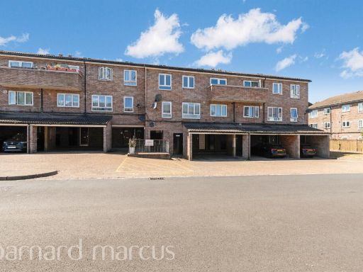 3 bedroom maisonette for sale in Douglas Close, Wallington, SM6 — £250,000 • 3 bed • 2 bath • 960 ft²
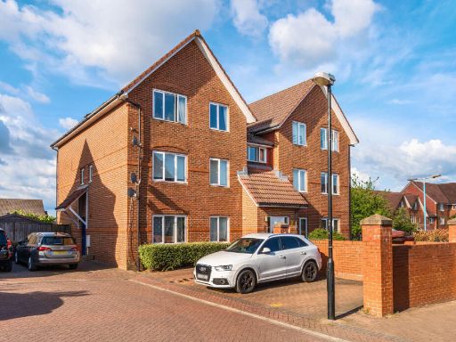 2 bedroom apartment for sale in Typhoon Way, Wallington, Surrey, SM6 — £320,000 • 2 bed • 1 bath • 778 ft²
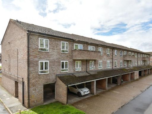 3 bedroom ground floor maisonette for sale in Douglas Close, Wallington, Surrey, SM6 — £248,000 • 3 bed • 1 bath • 1077 ft²
 2 bedroom maisonette for sale in Onslow Gardens, Wallington, SM6 — £390,000 • 2 bed • 1 bath • 782 ft²
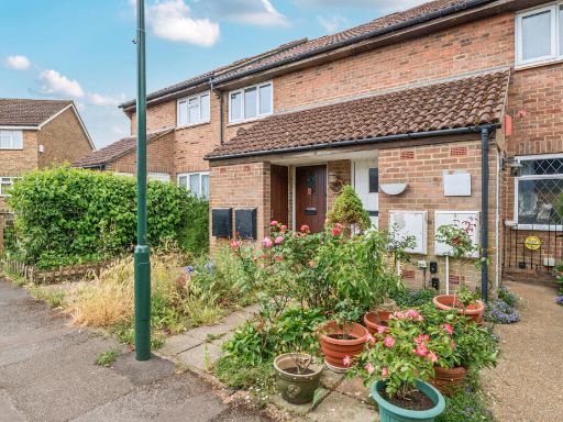 1 bedroom maisonette for sale in Plesman Way, Wallington, SM6 — £235,000 • 1 bed • 1 bath • 509 ft²
Meta
- {
"@context": "https://schema.org",
"@type": "Residence",
"name": "3 bedroom maisonette for sale in Brackley Close, Wallington…",
"description": "",
"url": "https://propertypiper.co.uk/property/bde781fd-20e2-4468-8165-e6b66e458bad",
"image": "https://image-a.propertypiper.co.uk/fbec49e9-c176-4d84-862a-4dea3afd78d8-1024.jpeg",
"address": {
"@type": "PostalAddress",
"streetAddress": "56 BRACKLEY CLOSE WALLINGTON ",
"postalCode": "SM6 9JR",
"addressLocality": "Sutton",
"addressRegion": "Carshalton and Wallington",
"addressCountry": "England"
},
"geo": {
"@type": "GeoCoordinates",
"latitude": 51.3553593018409,
"longitude": -0.12996567240375173
},
"numberOfRooms": 3,
"numberOfBathroomsTotal": 1,
"floorSize": {
"@type": "QuantitativeValue",
"value": 981,
"unitCode": "FTK"
},
"offers": {
"@type": "Offer",
"price": 349950,
"priceCurrency": "GBP",
"availability": "https://schema.org/InStock"
},
"additionalProperty": [
{
"@type": "PropertyValue",
"name": "Feature",
"value": "1970s"
},
{
"@type": "PropertyValue",
"name": "Feature",
"value": "apartment complex"
},
{
"@type": "PropertyValue",
"name": "Feature",
"value": "brick facade"
},
{
"@type": "PropertyValue",
"name": "Feature",
"value": "parking area"
},
{
"@type": "PropertyValue",
"name": "Feature",
"value": "suburban"
},
{
"@type": "PropertyValue",
"name": "Feature",
"value": "attached carport"
},
{
"@type": "PropertyValue",
"name": "Feature",
"value": "balcony"
},
{
"@type": "PropertyValue",
"name": "Feature",
"value": "modern"
},
{
"@type": "PropertyValue",
"name": "Feature",
"value": "brickwork"
},
{
"@type": "PropertyValue",
"name": "Feature",
"value": "concrete flooring"
},
{
"@type": "PropertyValue",
"name": "Feature",
"value": "outdoor space"
},
{
"@type": "PropertyValue",
"name": "Feature",
"value": "unmaintained"
},
{
"@type": "PropertyValue",
"name": "Feature",
"value": "exterior walls"
},
{
"@type": "PropertyValue",
"name": "Feature",
"value": "residential area"
},
{
"@type": "PropertyValue",
"name": "Feature",
"value": "fixer-upper"
}
]
}
High Res Floorplan Images
Compatible Floorplan Images
FloorplanImages Thumbnail