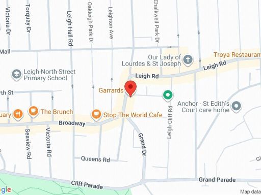
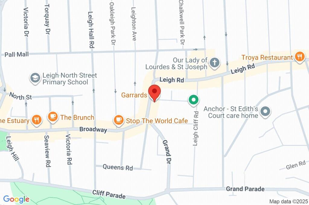
SS9 1AA - 1 bedroom apartment for sale in Broadway, LeighonSea, Essex…
View on Property Piper
1 bedroom apartment for sale in Broadway, Leigh-on-Sea, Essex, SS9
Property Details
- Price: £250000
- Bedrooms: 1
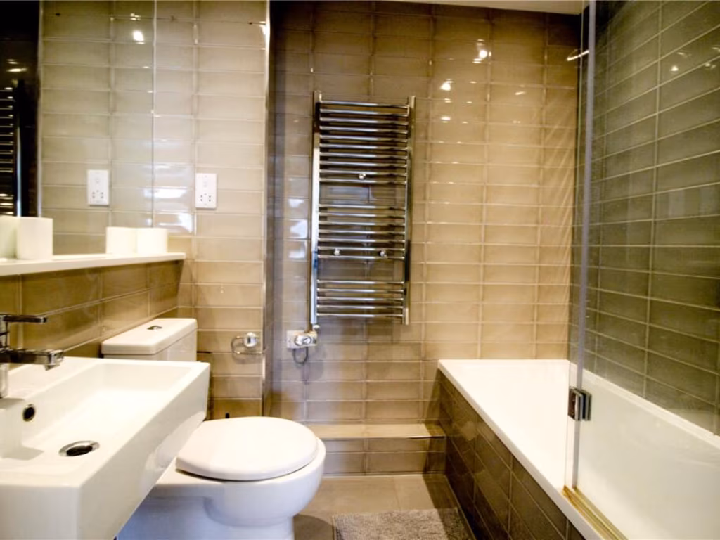
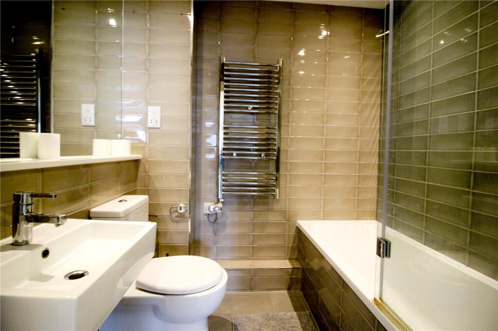
- Bathrooms: 1
- Property Type: undefined
- Property SubType: undefined
Brochure Descriptions
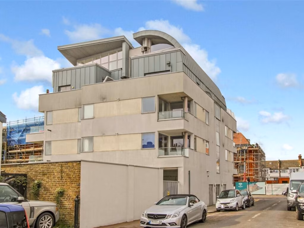
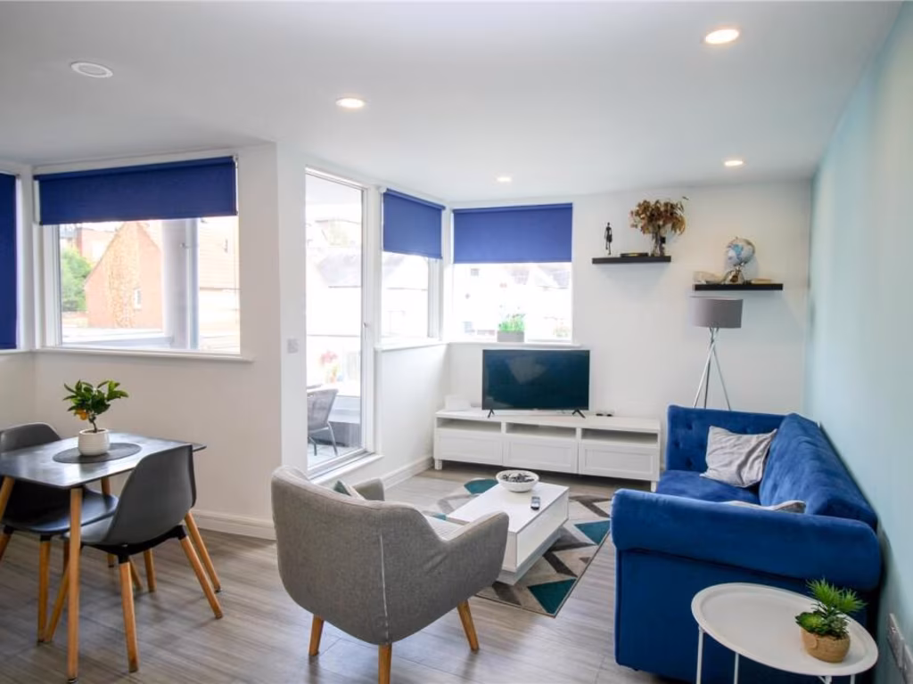
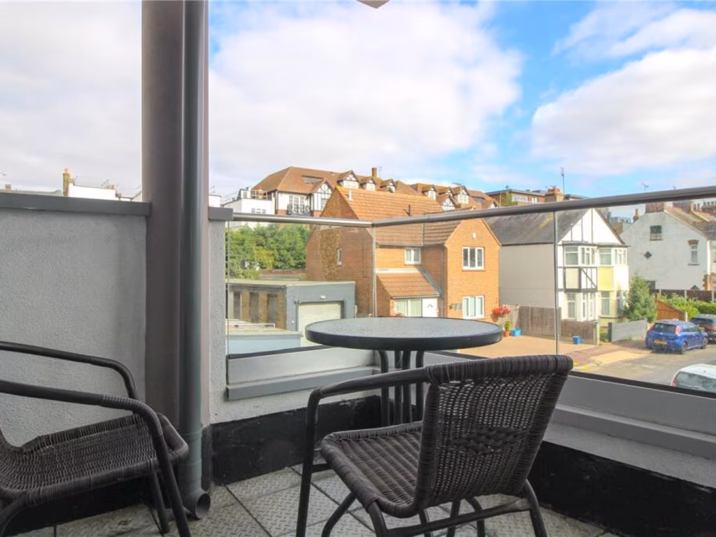
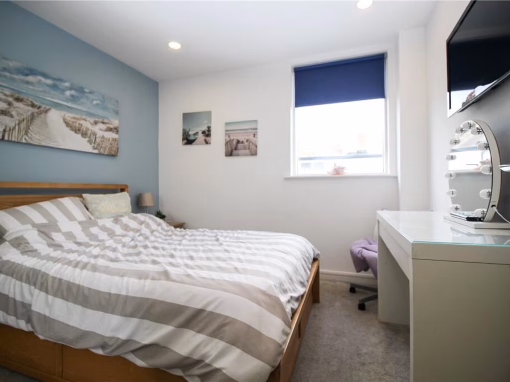
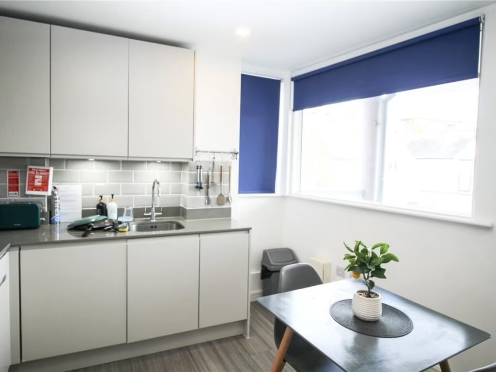
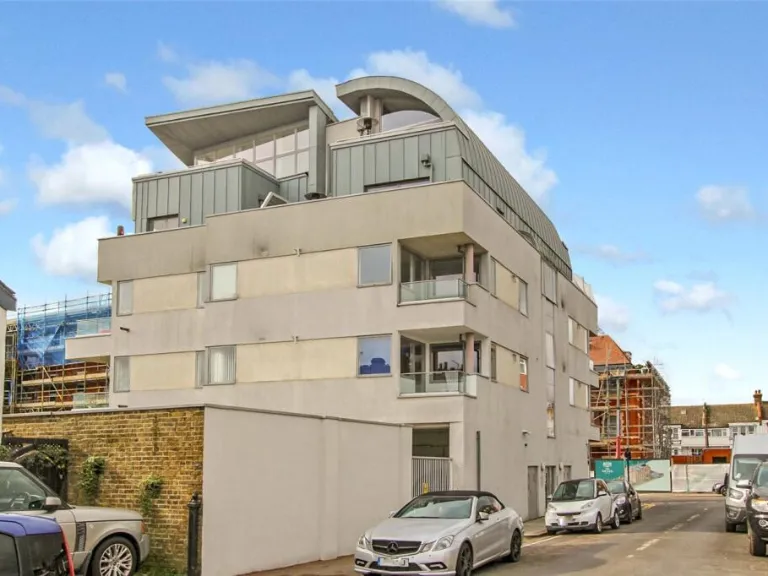
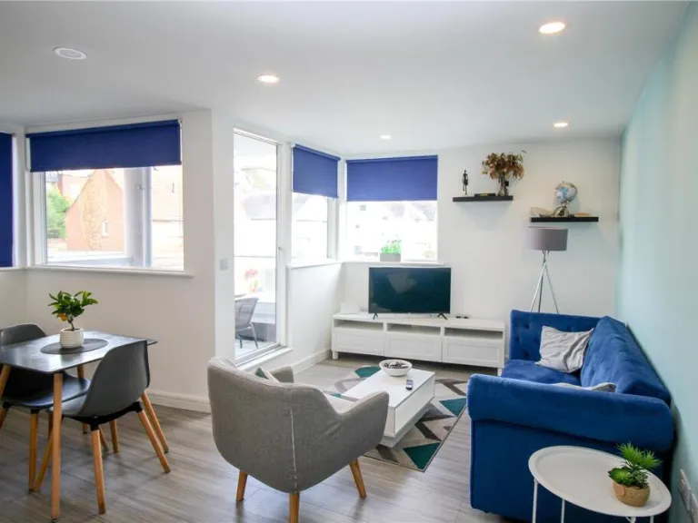
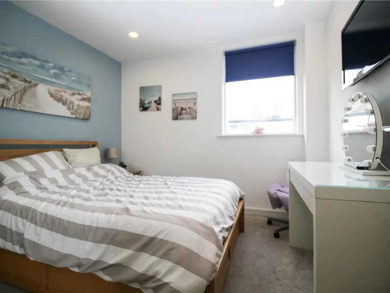
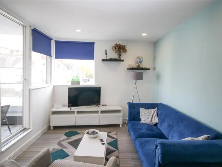
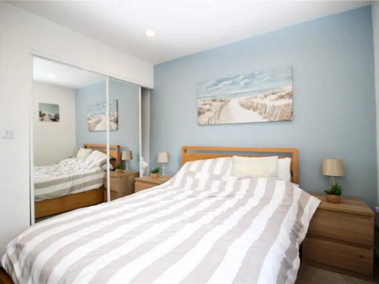
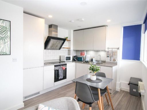
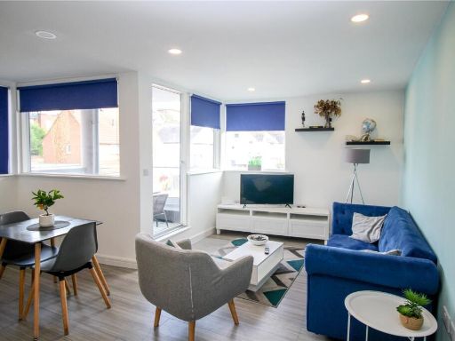
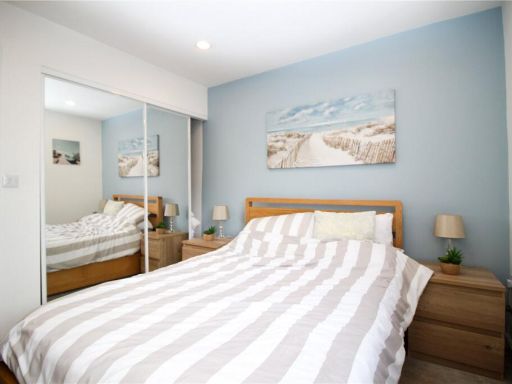
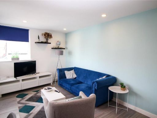
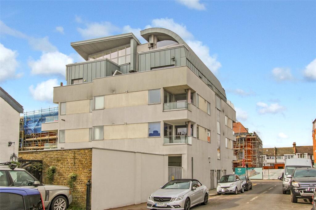
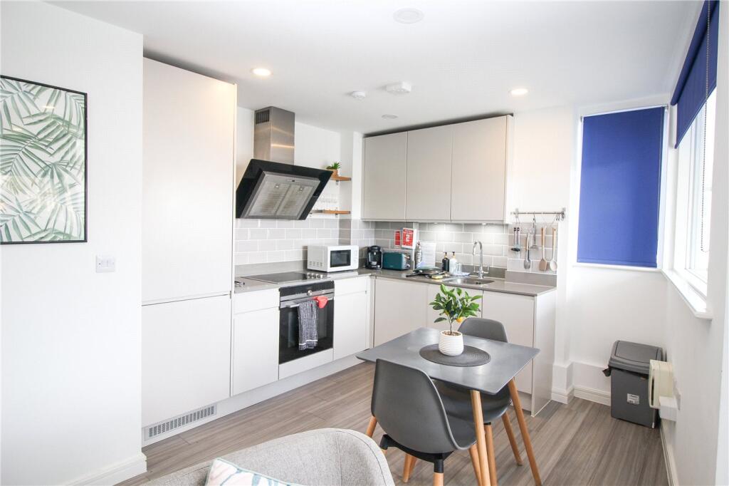
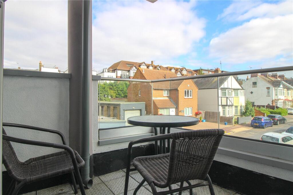
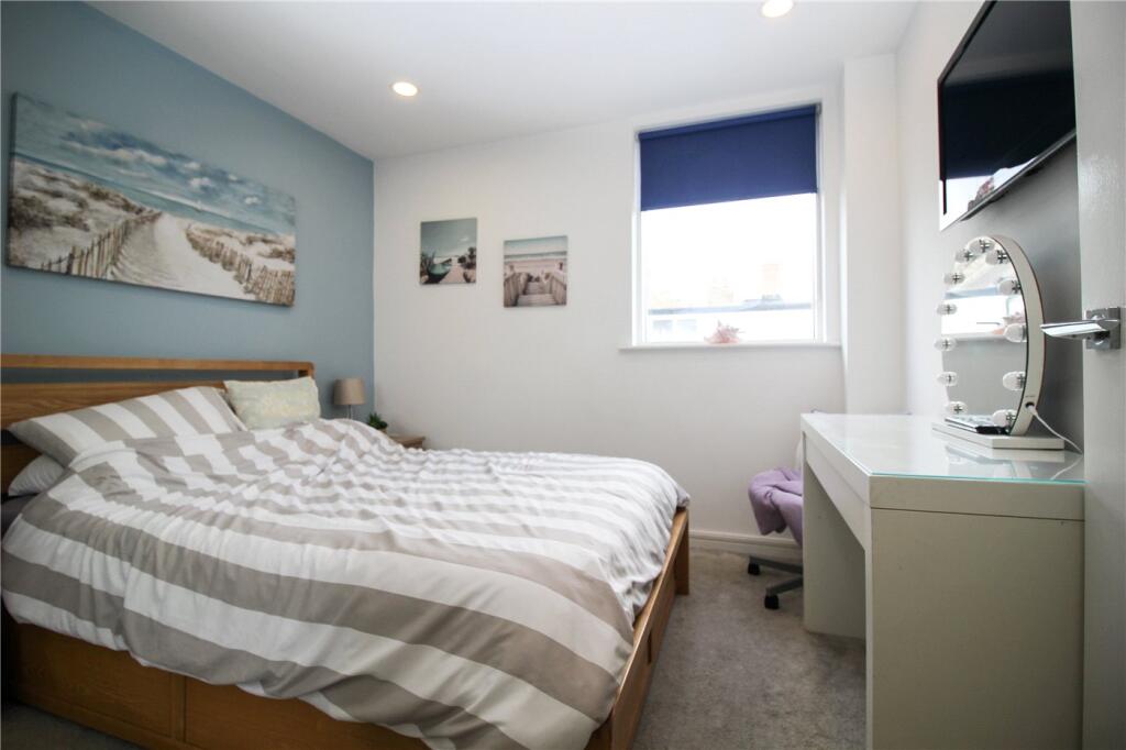
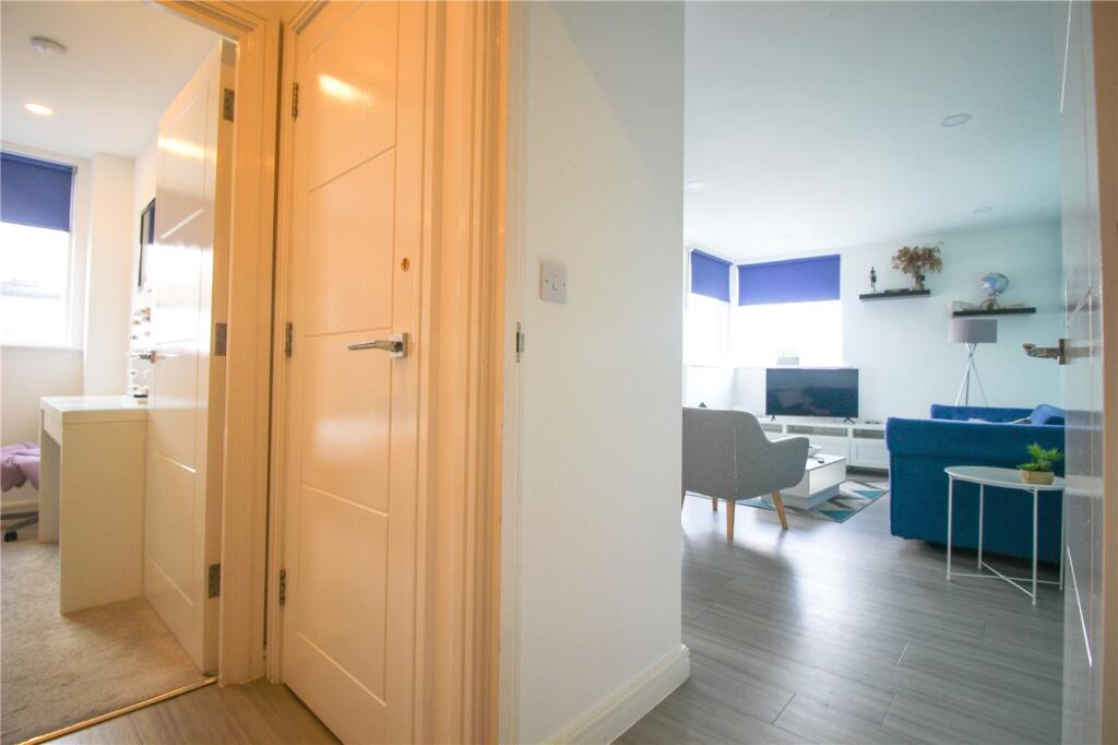
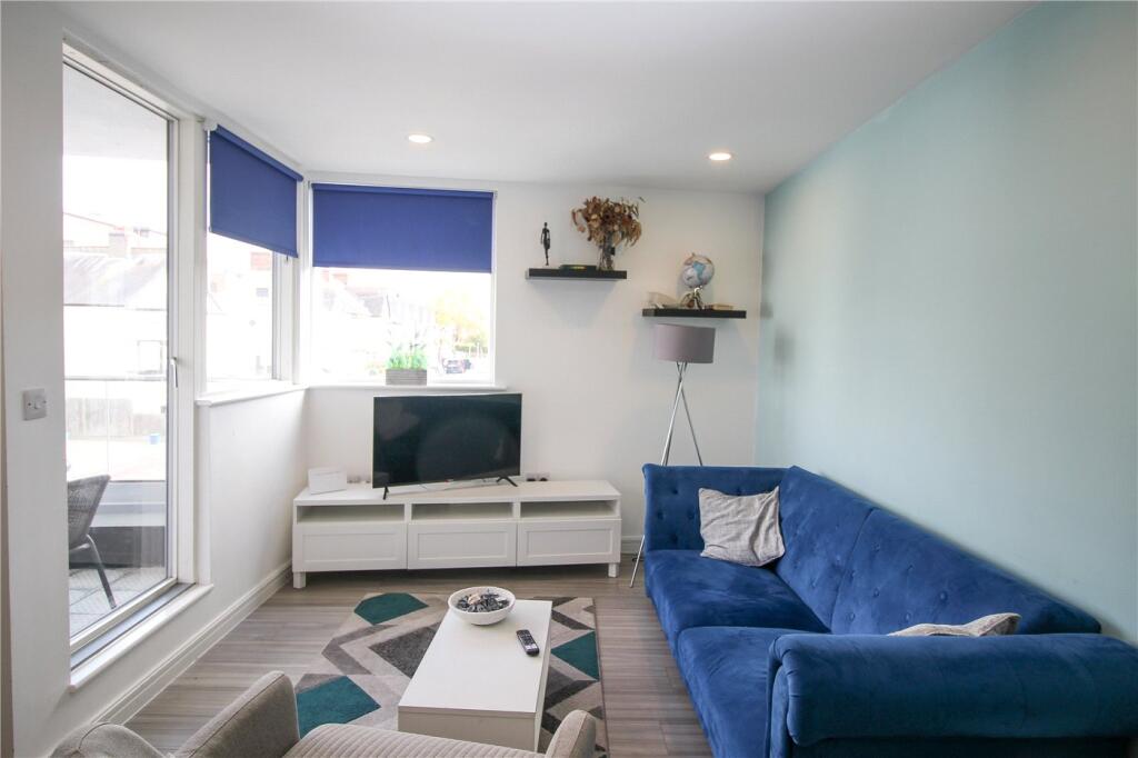
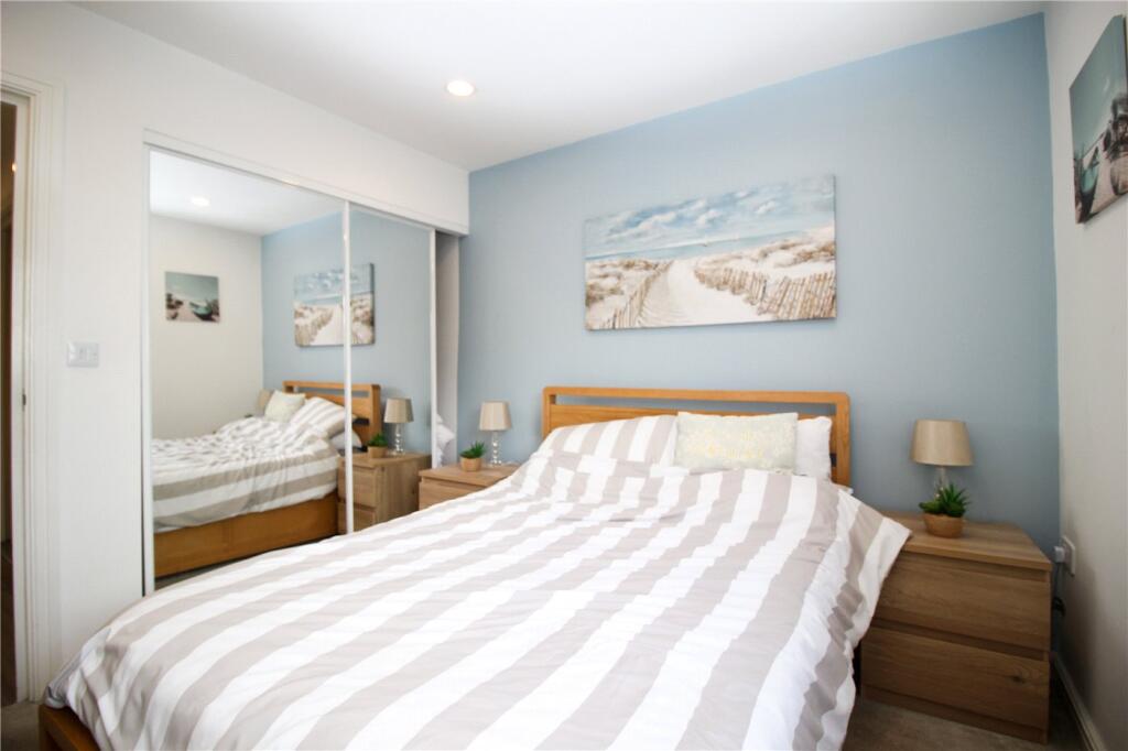
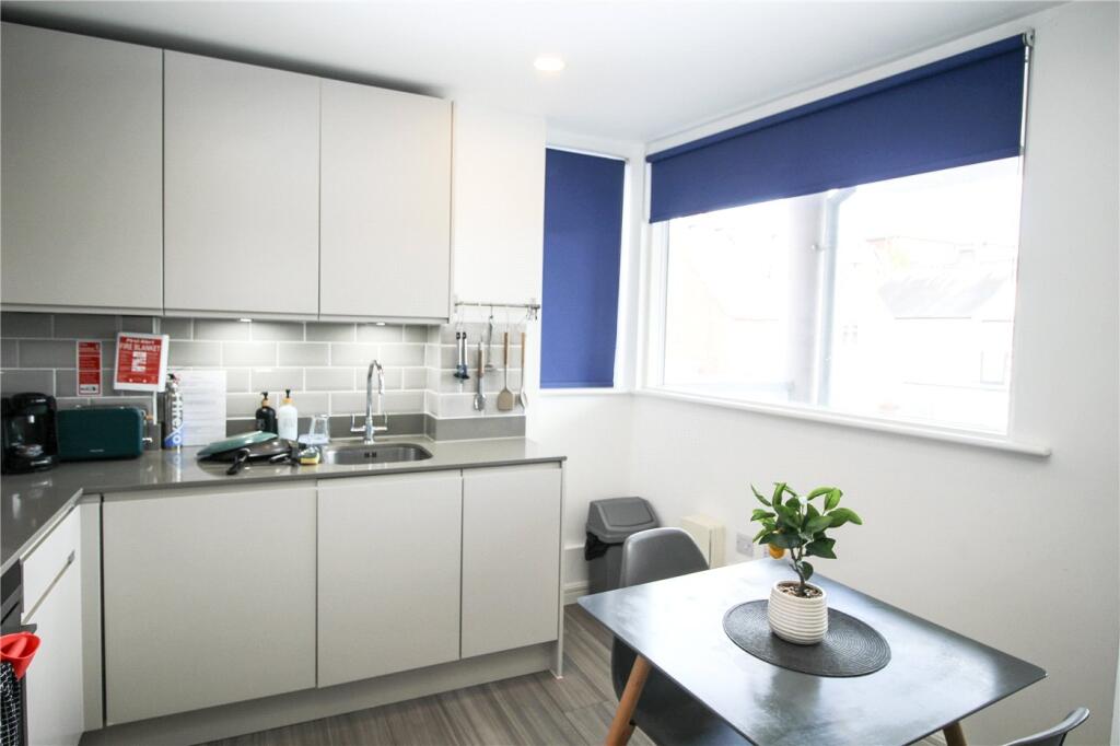
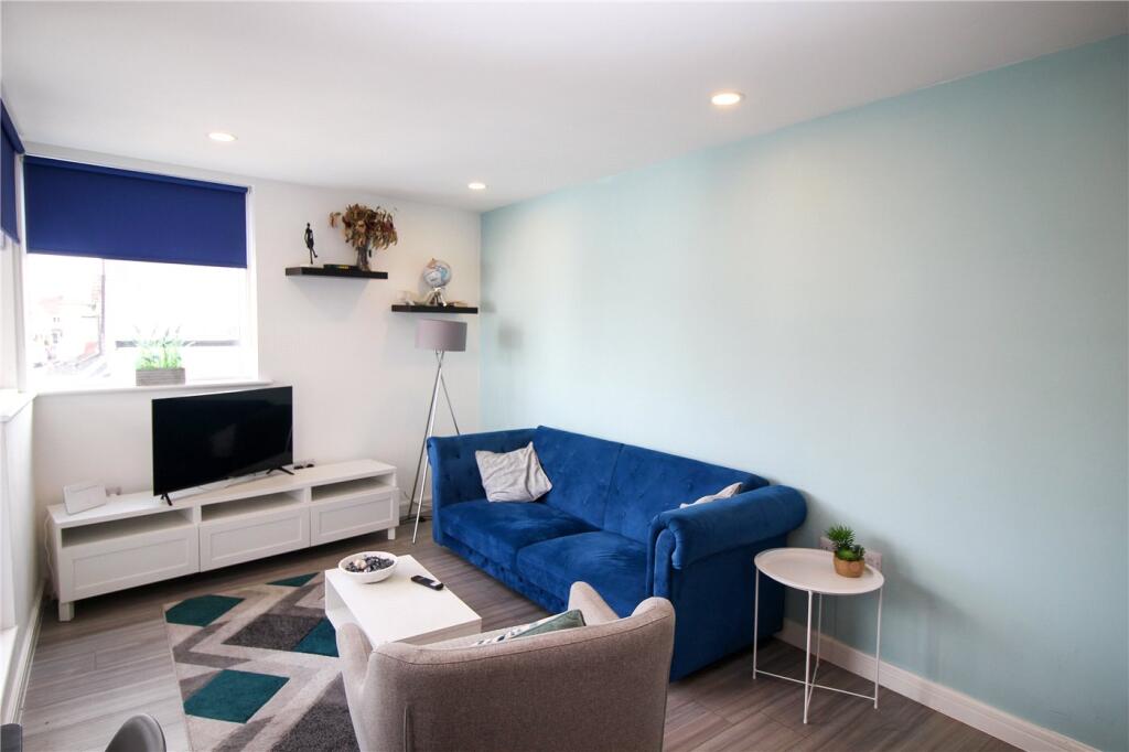
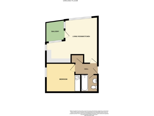
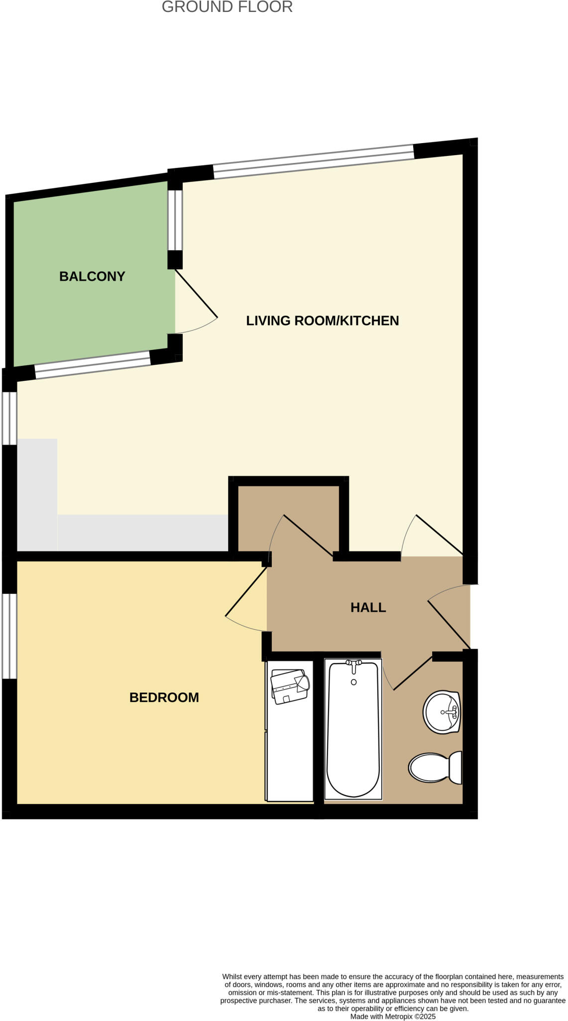
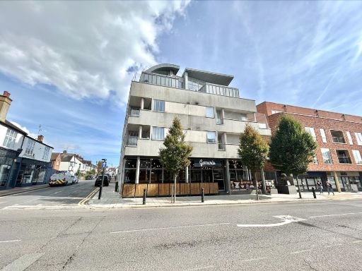
- First-floor one-bedroom apartment in a modern low-rise apartment block located on Broadway in Leigh-on-Sea. The unit appears to offer an open-plan living/dining area with a contemporary fitted kitchen, a double bedroom, and a bathroom. Interior finish is modern and bright with large windows and a light neutral palette. The building includes allocated on-site parking. The property is small in overall footprint (typical one-bedroom apartment) and the living/dining space is average for this type of flat. Surrounding views are urban/street with nearby coastal town amenities.
Image Descriptions
- modern apartment building Modern
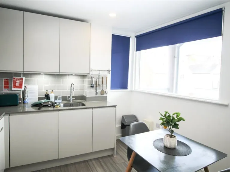
- kitchen modern
Rooms
- BALCONY:
- LIVING ROOM/KITCHEN:
- BEDROOM:
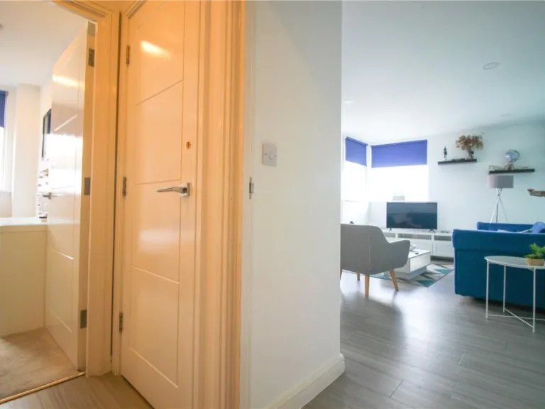
- HALL:
Textual Property Features
Detected Visual Features
- modern apartment
- flat
- balconies
- stucco exterior
- flat roof
- contemporary design
- urban living
- modern kitchen
- clean
- compact
- open plan
- integrated appliances
- white cabinetry
- grey flooring
- contemporary
- minimalist
- breakfast bar
EPC Details
- Fully double glazed
- Solid brick, as built, no insulation (assumed)
- Boiler and radiators, mains gas
- Low energy lighting in 80% of fixed outlets
- (other premises below)
Nearby Schools
- St Bernard's High School
- Belfairs Academy
- Westcliff High School for Boys Academy
- Blenheim Primary School
- Earls Hall Primary School
- Fairways Primary School
- Edwards Hall Primary School
- Leigh North Street Primary School
- Westcliff High School for Girls
- Chase High School
- The Eastwood Academy
- Saint Pierre School
- Chalkwell Hall Infant School
- West Leigh Infant School
- Our Lady of Lourdes Catholic Primary School
- Darlinghurst Academy
- Southend High School for Boys
- St Thomas More High School
- Prince Avenue Academy and Nursery
- Eastwood Primary School & Nursery
- Heycroft Primary School
- Chalkwell Hall Junior School
- St. Michael's School
- Westborough Academy
- West Leigh Junior School
Nearest Supermarkets
- Id: 882130160
- Tags:
- Addr:
- City: Westcliff-on-Sea
- Housenumber: 684-686
- Postcode: SS0 9HQ
- Street: London Road
- Brand: ALDI
- Brand:wikidata: Q41171672
- Brand:wikipedia: en:Aldi
- Building: yes
- Contact:
- Website: https://stores.aldi.co.uk/westcliff-on-sea/684-686-london-road
- Name: ALDI
- Shop: supermarket
- TagsNormalized:
- Lat: 51.5453729
- Lon: 0.681189
- FullGeoHash: u10mpx818cgq
- PartitionGeoHash: u10m
- Images:
- FoodStandards: null
- Distance: 1420.2
,- Id: 638840405
- Tags:
- Brand: Waitrose
- Brand:wikidata: Q771734
- Brand:wikipedia: en:Waitrose
- Building: yes
- Name: Waitrose
- Official_name: Waitrose & Partners
- Operator: Waitrose & Partners
- Shop: supermarket
- Wheelchair: yes
- TagsNormalized:
- Lat: 51.548437
- Lon: 0.6546787
- FullGeoHash: u10mqbherj5u
- PartitionGeoHash: u10m
- Images:
- FoodStandards: null
- Distance: 826.7
,- Id: 4363803035
- Tags:
- Name: Co-op
- Shop: supermarket
- TagsNormalized:
- Lat: 51.5479296
- Lon: 0.6580959
- FullGeoHash: u10mqbp0qwxc
- PartitionGeoHash: u10m
- Images:
- FoodStandards: null
- Distance: 670
}
Nearest Religious buildings
- Id: 4363803037
- Tags:
- Amenity: place_of_worship
- Denomination: congregational
- Name: Union Congregational Church
- Religion: christian
- TagsNormalized:
- place of worship
- congregational
- church
- christian
- Lat: 51.5435312
- Lon: 0.6582407
- FullGeoHash: u10mnzpqf4eu
- PartitionGeoHash: u10m
- Images:
- FoodStandards: null
- Distance: 254.6
,- Id: 88417461
- Tags:
- Addr:
- City: Leigh-on-Sea
- Housenumber: 161
- Postcode: SS9 1JF
- Street: Leigh Road
- Amenity: place_of_worship
- Building: yes
- Denomination: catholic
- Email: office@lourdesleigh.org
- Name: Our Lady of Lourdes & St Joseph
- Phone: +44 1702 478078
- Religion: christian
- Service_times: Monday-Thursday: 9am, Friday: 12pm, 10.30amw, Saturday: 10.30am, 5.30pm, Sunday: 8am, 9.30am, 11.30am
- Website: lourdesleigh.org
- Wheelchair: yes
- TagsNormalized:
- place of worship
- catholic
- christian
- church
- Lat: 51.5433161
- Lon: 0.6639169
- FullGeoHash: u10mpp5mw6s2
- PartitionGeoHash: u10m
- Images:
- FoodStandards: null
- Distance: 218.2
,- Id: 316782553
- Tags:
- Amenity: place_of_worship
- Denomination: baptist
- Name: Leigh Road Baptist Church
- Node_id: 316782553
- Religion: christian
- Source: NPE
- Source:name: OS Open Local Important Buildings Layer
- TagsNormalized:
- place of worship
- baptist
- church
- christian
- Lat: 51.5434292
- Lon: 0.6627895
- FullGeoHash: u10mpp4whpee
- PartitionGeoHash: u10m
- Images:
- FoodStandards: null
- Distance: 168.6
}
Nearest Medical buildings
- Id: 873531004
- Tags:
- Addr:
- City: Leigh-on-Sea
- Housenumber: 185
- Postcode: SS9 4JH
- Street: Elmsleigh Drive
- Amenity: pharmacy
- Dispensing: yes
- Healthcare: pharmacy
- Name: Leigh Pharmacy
- Website: https://www.nhs.uk/Services/pharmacies/PctServices/DefaultView.aspx?id=FAQ68
- TagsNormalized:
- Lat: 51.5552488
- Lon: 0.6556367
- FullGeoHash: u10mqcm7j6yn
- PartitionGeoHash: u10m
- Images:
- FoodStandards: null
- Distance: 1498.3
,- Id: 2090331124
- Tags:
- Amenity: pharmacy
- Healthcare: pharmacy
- Name: Longthornes Pharmacy
- TagsNormalized:
- Lat: 51.5458601
- Lon: 0.678129
- FullGeoHash: u10mprtu3sc8
- PartitionGeoHash: u10m
- Images:
- FoodStandards: null
- Distance: 1232.8
,- Id: 6268331257
- Tags:
- Addr:
- City: Leigh-on-Sea
- Housenumber: 1065
- Postcode: SS9 3JP
- Street: London Road
- Amenity: pharmacy
- Dispensing: yes
- Healthcare: pharmacy
- Name: Derix Healthcare Pharmacy
- Opening_hours: Su-Fr 08:00-23:00; Sa 08:00-21:00
- Website: https://www.nhs.uk/Services/pharmacies/PctServices/DefaultView.aspx?id=FH669
- TagsNormalized:
- Lat: 51.5476061
- Lon: 0.6633608
- FullGeoHash: u10mppgn96jx
- PartitionGeoHash: u10m
- Images:
- FoodStandards: null
- Distance: 613.9
,- Id: 391166953
- Tags:
- Amenity: doctors
- Building: yes
- Healthcare: doctor
- TagsNormalized:
- doctor
- doctors
- health
- healthcare
- Lat: 51.5473084
- Lon: 0.6627151
- FullGeoHash: u10mppfsf6sp
- PartitionGeoHash: u10m
- Images:
- FoodStandards: null
- Distance: 572.4
}
Nearest Airports
- Id: 121158889
- Tags:
- Aerodrome: continental
- Aeroway: aerodrome
- Fhrs:
- Authority: City of London Corporation
- Iata: LCY
- Icao: EGLC
- Name: London City Airport
- Operator: London City Airport Limited
- Ref: LCY
- Website: https://www.londoncityairport.com/
- Wikidata: Q8982
- Wikipedia: en:London City Airport
- TagsNormalized:
- airport
- continental airport
- Lat: 51.5042658
- Lon: 0.0539987
- FullGeoHash: u10j10p64702
- PartitionGeoHash: u10j
- Images:
- FoodStandards: null
- Distance: 42226.3
,- Id: 103894219
- Tags:
- Aerodrome: international
- Aeroway: aerodrome
- Iata: SEN
- Icao: EGMC
- Name: London Southend Airport
- Old_name: Southend Municipal Airport
- Ref: SEN
- Wikidata: Q1415441
- TagsNormalized:
- airport
- international airport
- Lat: 51.5701749
- Lon: 0.6924624
- FullGeoHash: u10mru04p937
- PartitionGeoHash: u10m
- Images:
- FoodStandards: null
- Distance: 3781.1
}
Nearest Leisure Facilities
- Id: 443794820
- Tags:
- Leisure: garden
- Name: Leigh Hill Garden
- TagsNormalized:
- Lat: 51.5399549
- Lon: 0.6542252
- FullGeoHash: u10mnys3uxcw
- PartitionGeoHash: u10m
- Images:
- FoodStandards: null
- Distance: 550
,- Id: 1512778008
- Tags:
- TagsNormalized:
- Lat: 51.5388182
- Lon: 0.6642769
- FullGeoHash: u10mpn7equ0c
- PartitionGeoHash: u10m
- Images:
- FoodStandards: null
- Distance: 433.2
,- Id: 137972628
- Tags:
- Leisure: park
- Name: Leigh Cliffs
- TagsNormalized:
- Lat: 51.5395787
- Lon: 0.6581177
- FullGeoHash: u10mnyrpz3b4
- PartitionGeoHash: u10m
- Images:
- FoodStandards: null
- Distance: 367.8
,- Id: 1080771331
- Tags:
- Access: private
- Leisure: garden
- TagsNormalized:
- Lat: 51.541523
- Lon: 0.6657926
- FullGeoHash: u10mpnug4h6b
- PartitionGeoHash: u10m
- Images:
- FoodStandards: null
- Distance: 322.1
,- Id: 476602843
- Tags:
- Building: yes
- Leisure: fitness_centre
- Name: Armour Leisure
- TagsNormalized:
- fitness
- fitness centre
- leisure
- Lat: 51.5434175
- Lon: 0.657818
- FullGeoHash: u10mnzpn0m2t
- PartitionGeoHash: u10m
- Images:
- FoodStandards: null
- Distance: 272.9
}
Nearest Tourist attractions
- Id: 4701264982
- Tags:
- Name: Lynn Tait Gallery at the Old Foundart
- Tourism: gallery
- TagsNormalized:
- Lat: 51.5403302
- Lon: 0.6498254
- FullGeoHash: u10mny9hnjbv
- PartitionGeoHash: u10m
- Images:
- FoodStandards: null
- Distance: 820.1
,- Id: 4701264956
- Tags:
- Addr:
- City: Leigh-on-Sea
- Housename: The Old Smithy
- Housenumber: 13a
- Postcode: SS9 2EN
- Street: High Street
- Name: Leigh Heritage Centre
- Operator: Leith Society
- Tourism: museum
- Website: http://www.leighsociety.com/leighheritagecentre.htm
- Wikidata: Q113454711
- TagsNormalized:
- Lat: 51.5400447
- Lon: 0.650628
- FullGeoHash: u10mny9f88xq
- PartitionGeoHash: u10m
- Images:
- FoodStandards: null
- Distance: 776
,- Id: 4537507305
- Tags:
- Artwork_type: photo
- Name: Francesca Mafffeo Gallery
- Opening_hours: Tu 10:00-17:00; We 10:00-14:30; Th 10:00-17:00; Fr 10:00-17:00; Sa 10:00-17:00
- Tourism: gallery
- Website: https://www.francescamaffeogallery.com/
- TagsNormalized:
- Lat: 51.5428875
- Lon: 0.6615501
- FullGeoHash: u10mpp1ep4xs
- PartitionGeoHash: u10m
- Images:
- FoodStandards: null
- Distance: 74.5
}
Nearest Train stations
- Id: 314994462
- Tags:
- Name: Prittlewell
- Naptan:
- Network: National Rail
- Public_transport: station
- Railway: station
- Ref:
- Wikidata: Q1880808
- Wikipedia: en:Prittlewell railway station
- TagsNormalized:
- Lat: 51.5505931
- Lon: 0.7106494
- FullGeoHash: u10t20mrzr49
- PartitionGeoHash: u10t
- Images:
- FoodStandards: null
- Distance: 3538
,- Id: 6733461093
- Tags:
- Name: Southend Central
- Naptan:
- Network: National Rail
- Public_transport: station
- Railway: station
- Ref:
- Wikidata: Q593051
- Wikipedia: en:Southend Central railway station
- TagsNormalized:
- Lat: 51.5373587
- Lon: 0.7116503
- FullGeoHash: u10t0nn4yeuz
- PartitionGeoHash: u10t
- Images:
- FoodStandards: null
- Distance: 3525.6
,- Id: 7140234411
- Tags:
- Addr:
- Name: Southend Victoria
- Naptan:
- Network: National Rail
- Public_transport: station
- Railway: station
- Ref:
- Website: http://www.nationalrail.co.uk/stations/sov/details.html
- Wikidata: Q3254036
- Wikipedia: en:Southend Victoria railway station
- TagsNormalized:
- Lat: 51.5429361
- Lon: 0.7114814
- FullGeoHash: u10t0pn56ewy
- PartitionGeoHash: u10t
- Images:
- FoodStandards: null
- Distance: 3472.6
,- Id: 7140234412
- Tags:
- Name: Westcliff
- Naptan:
- Network: National Rail
- Public_transport: station
- Railway: station
- Ref:
- Wikidata: Q2319277
- Wikipedia: en:Westcliff railway station
- TagsNormalized:
- Lat: 51.5374449
- Lon: 0.6915156
- FullGeoHash: u10mpwpe3kp3
- PartitionGeoHash: u10m
- Images:
- FoodStandards: null
- Distance: 2158
,- Id: 6733461094
- Tags:
- Name: Chalkwell
- Naptan:
- Network: National Rail
- Public_transport: station
- Railway: station
- Ref:
- Source: NPE
- Wikidata: Q744484
- Wikipedia: en:Chalkwell railway station
- TagsNormalized:
- Lat: 51.5386117
- Lon: 0.6698419
- FullGeoHash: u10mpnrf0mw6
- PartitionGeoHash: u10m
- Images:
- FoodStandards: null
- Distance: 716.5
}
Nearest Bus stations and stops
- Id: 7729101959
- Tags:
- Bus: yes
- Highway: bus_stop
- Name: Grand Drive
- Naptan:
- AtcoCode: 15800636
- NaptanCode: soadatjm
- Verified: no
- Public_transport: platform
- Source: naptan
- TagsNormalized:
- Lat: 51.539923
- Lon: 0.6623415
- FullGeoHash: u10mpnd3cdj8
- PartitionGeoHash: u10m
- Images:
- FoodStandards: null
- Distance: 267.8
,- Id: 7726448811
- Tags:
- Highway: bus_stop
- Name: Leigh Cliff Road
- Naptan:
- AtcoCode: 15800642
- NaptanCode: soadatja
- Verified: no
- Public_transport: platform
- Source: naptan
- TagsNormalized:
- Lat: 51.542973
- Lon: 0.6638754
- FullGeoHash: u10mpp57t6t6
- PartitionGeoHash: u10m
- Images:
- FoodStandards: null
- Distance: 197.2
,- Id: 7726448810
- Tags:
- Bus: yes
- Highway: bus_stop
- Name: Redcliff Drive
- Naptan:
- AtcoCode: 15800645
- NaptanCode: soadatdt
- Verified: no
- Public_transport: platform
- Source: naptan
- TagsNormalized:
- Lat: 51.5414857
- Lon: 0.6596636
- FullGeoHash: u10mpnb6gm2f
- PartitionGeoHash: u10m
- Images:
- FoodStandards: null
- Distance: 139.7
,- Id: 7726356134
- Tags:
- Bus: yes
- Highway: bus_stop
- Name: Leighton Avenue
- Naptan:
- AtcoCode: 15800644
- NaptanCode: soadatdp
- Verified: no
- Public_transport: platform
- Source: naptan
- TagsNormalized:
- Lat: 51.5415839
- Lon: 0.6596982
- FullGeoHash: u10mpnb7kpde
- PartitionGeoHash: u10m
- Images:
- FoodStandards: null
- Distance: 131.4
,- Id: 7726356133
- Tags:
- Highway: bus_stop
- Name: Chalkwell Park Drive
- Naptan:
- AtcoCode: 15800643
- NaptanCode: soadatjd
- Verified: no
- Public_transport: platform
- Source: naptan
- TagsNormalized:
- Lat: 51.5429614
- Lon: 0.6624036
- FullGeoHash: u10mpp47e07v
- PartitionGeoHash: u10m
- Images:
- FoodStandards: null
- Distance: 111.8
}
Nearest Hotels
- Id: 644650135
- Tags:
- Addr:
- Postcode: SS2 6UN
- Street: Aviation Way
- Fhrs:
- Name: Skylark Hotel
- Rooms: 75
- Source:
- Tourism: hotel
- Website: http://www.skylarkhotel.co.uk/
- TagsNormalized:
- Lat: 51.5694749
- Lon: 0.6843515
- FullGeoHash: u10mrefmfwck
- PartitionGeoHash: u10m
- Images:
- FoodStandards: null
- Distance: 3422.9
,- Id: 94207804
- Tags:
- Addr:
- City: Southend-on-Sea
- Postcode: SS2 6GB
- Street: Thanet Grange
- Brand: Premier Inn
- Brand:wikidata: Q2108626
- Brand:wikipedia: en:Premier Inn
- Building: yes
- Internet_access: wlan
- Internet_access:fee: customers
- Internet_access:operator: Virgin Media
- Internet_access:ssid: Premier Inn Free Wi-Fi
- Name: Premier Inn
- Operator: Whitbread
- Phone: +44 333 321 9014
- Smoking: outside
- Source: Bing
- Tourism: hotel
- Website: https://www.premierinn.com/gb/en/home.html
- TagsNormalized:
- Lat: 51.5625626
- Lon: 0.6818252
- FullGeoHash: u10mrd8mxwmd
- PartitionGeoHash: u10m
- Images:
- FoodStandards: null
- Distance: 2669.3
,- Id: 1050176048
- Tags:
- Name: Clifton Lodge
- Tourism: hotel
- TagsNormalized:
- Lat: 51.5435658
- Lon: 0.6988235
- FullGeoHash: u10mpzhz5c0d
- PartitionGeoHash: u10m
- Images:
- FoodStandards: null
- Distance: 2600.5
}
Tags
- modern apartment
- flat
- balconies
- stucco exterior
- flat roof
- contemporary design
- urban living
- modern kitchen
- clean
- compact
- open plan
- integrated appliances
- white cabinetry
- grey flooring
- contemporary
- minimalist
- breakfast bar
Local Market Stats
- Average Price/sqft: £427
- Avg Income: £48800
- Rental Yield: 3.8%
- Social Housing: 5%
- Planning Success Rate: 21%
AirBnB Data
- 1km average: £102/night
- Listings in 1km: 9
Similar Properties
 1 bedroom flat for sale in Grand View Apartments, Leigh-On-Sea, SS9 — £250,000 • 1 bed • 1 bath • 397 ft²
 1 bedroom apartment for sale in Leigh Road, Leigh-on-Sea, Essex, SS9 — £220,000 • 1 bed • 1 bath • 571 ft²
 1 bedroom apartment for sale in Leigh Road, Leigh-on-Sea, SS9 — £220,000 • 1 bed • 1 bath • 571 ft²
 1 bedroom apartment for sale in Leigh Road, Leigh-on-sea, SS9 — £220,000 • 1 bed • 1 bath • 571 ft²
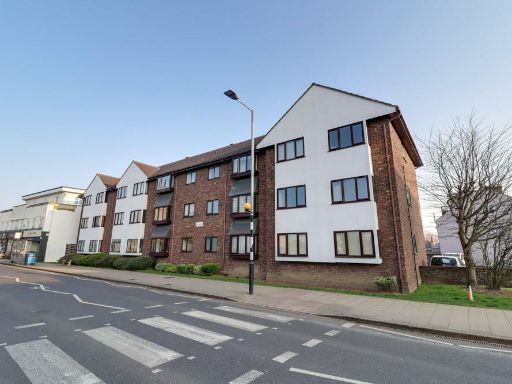 1 bedroom flat for sale in Leigh Road, Leigh-On-Sea, SS9 — £220,000 • 1 bed • 1 bath • 571 ft²
 2 bedroom apartment for sale in * NO ONWARD CHAIN * Leigh Road, Leigh-on-Sea, SS9 — £375,000 • 2 bed • 1 bath • 951 ft²
Meta
- {
"@context": "https://schema.org",
"@type": "Residence",
"name": "1 bedroom apartment for sale in Broadway, LeighonSea, Essex…",
"description": "",
"url": "https://propertypiper.co.uk/property/a38de356-5034-4e2d-9071-7ecd9337a32b",
"image": "https://image-a.propertypiper.co.uk/add79f28-3f18-47c6-ac1b-ab9c175baa05-1024.jpeg",
"address": {
"@type": "PostalAddress",
"streetAddress": "Broadway, Leigh-on-Sea, Essex, SS9",
"postalCode": "SS9 1AA",
"addressLocality": "Southend-on-Sea",
"addressRegion": "Southend West",
"addressCountry": "England"
},
"geo": {
"@type": "GeoCoordinates",
"latitude": 51.54223877443159,
"longitude": 0.661279639748592
},
"numberOfRooms": 1,
"numberOfBathroomsTotal": 1,
"floorSize": {
"@type": "QuantitativeValue",
"value": 437,
"unitCode": "FTK"
},
"offers": {
"@type": "Offer",
"price": 250000,
"priceCurrency": "GBP",
"availability": "https://schema.org/InStock"
},
"additionalProperty": [
{
"@type": "PropertyValue",
"name": "Feature",
"value": "modern apartment"
},
{
"@type": "PropertyValue",
"name": "Feature",
"value": "flat"
},
{
"@type": "PropertyValue",
"name": "Feature",
"value": "balconies"
},
{
"@type": "PropertyValue",
"name": "Feature",
"value": "stucco exterior"
},
{
"@type": "PropertyValue",
"name": "Feature",
"value": "flat roof"
},
{
"@type": "PropertyValue",
"name": "Feature",
"value": "contemporary design"
},
{
"@type": "PropertyValue",
"name": "Feature",
"value": "urban living"
},
{
"@type": "PropertyValue",
"name": "Feature",
"value": "modern kitchen"
},
{
"@type": "PropertyValue",
"name": "Feature",
"value": "clean"
},
{
"@type": "PropertyValue",
"name": "Feature",
"value": "compact"
},
{
"@type": "PropertyValue",
"name": "Feature",
"value": "open plan"
},
{
"@type": "PropertyValue",
"name": "Feature",
"value": "integrated appliances"
},
{
"@type": "PropertyValue",
"name": "Feature",
"value": "white cabinetry"
},
{
"@type": "PropertyValue",
"name": "Feature",
"value": "grey flooring"
},
{
"@type": "PropertyValue",
"name": "Feature",
"value": "contemporary"
},
{
"@type": "PropertyValue",
"name": "Feature",
"value": "minimalist"
},
{
"@type": "PropertyValue",
"name": "Feature",
"value": "breakfast bar"
}
]
}
High Res Floorplan Images
Compatible Floorplan Images
FloorplanImages Thumbnail