HG2 0ES - 3 bedroom flat for sale in Beech Grove, Harrogate, North Yo…
View on Property Piper
3 bedroom flat for sale in Beech Grove, Harrogate, North Yorkshire, HG2
Property Details
- Price: £635000
- Bedrooms: 3
- Bathrooms: 2
- Property Type: undefined
- Property SubType: undefined
Brochure Descriptions
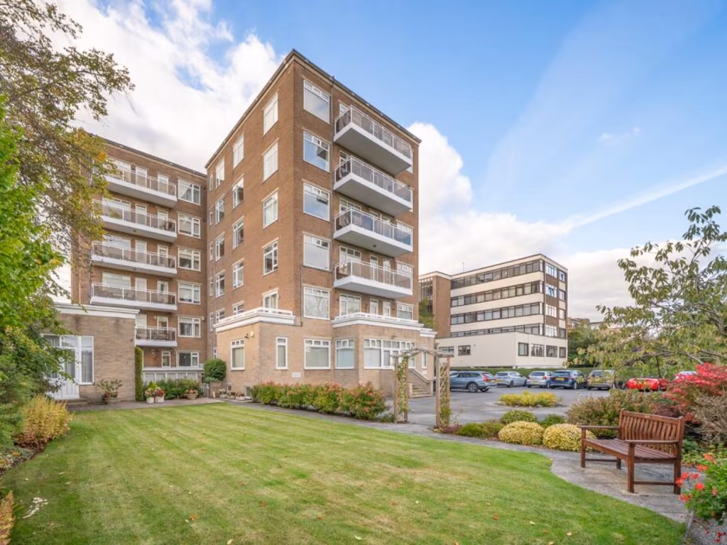
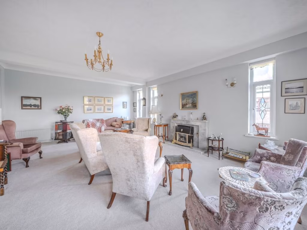
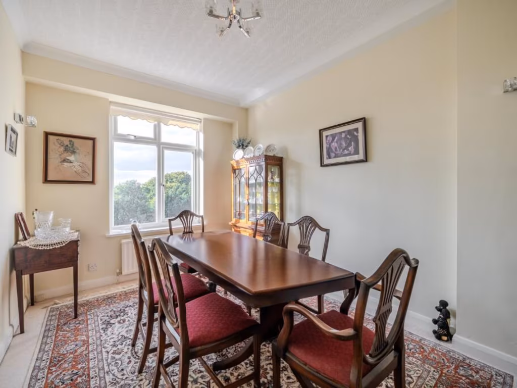
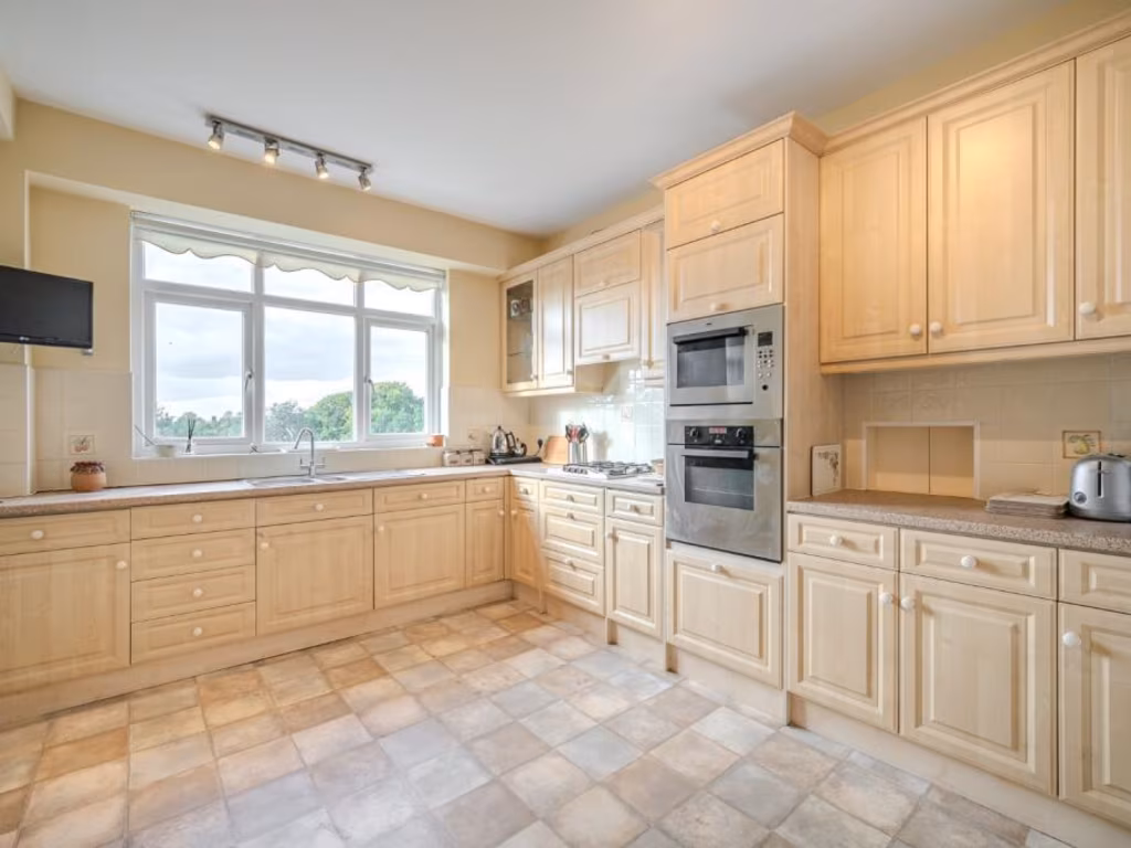
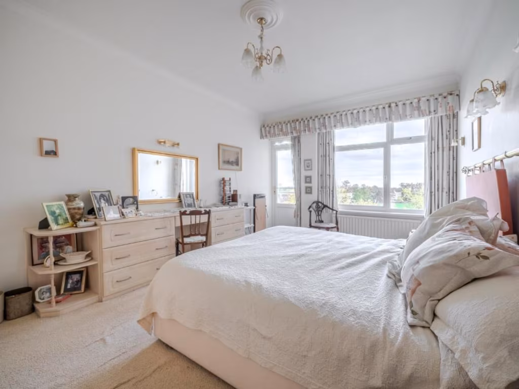
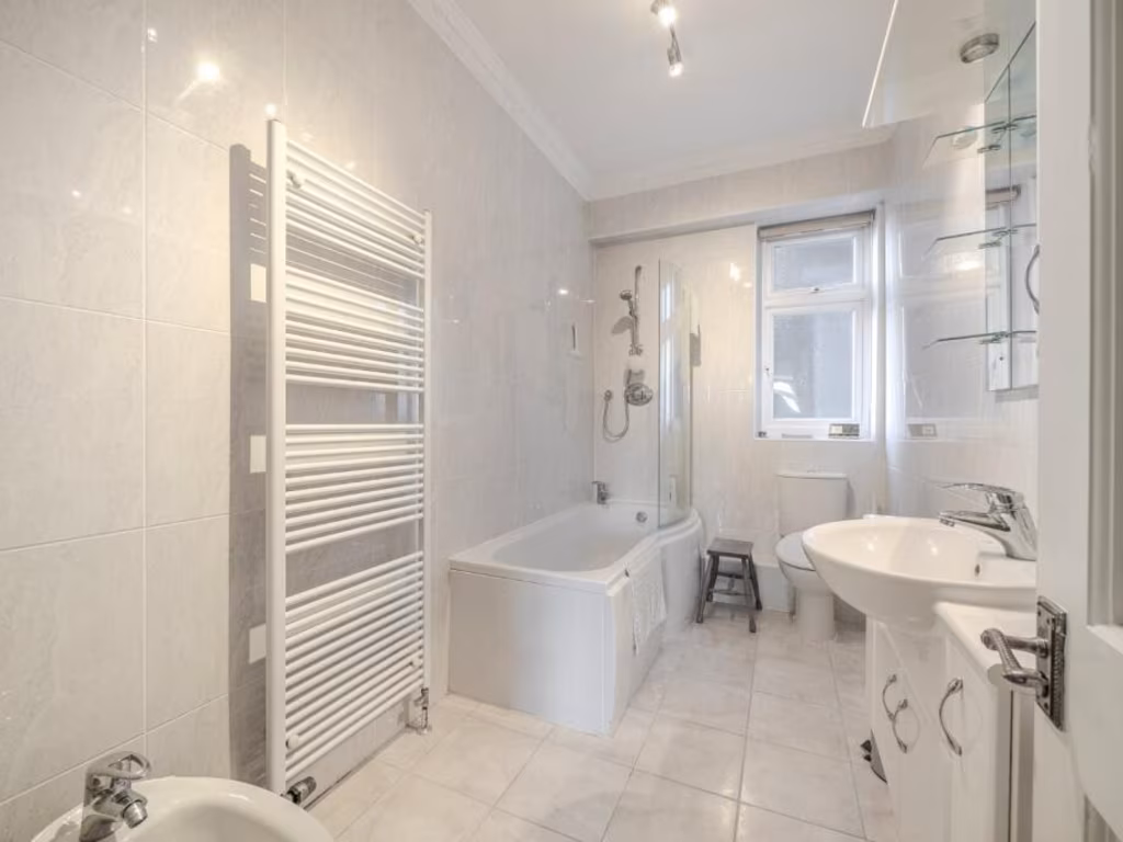
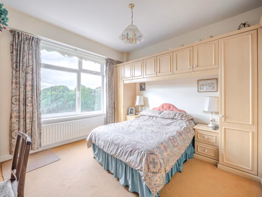
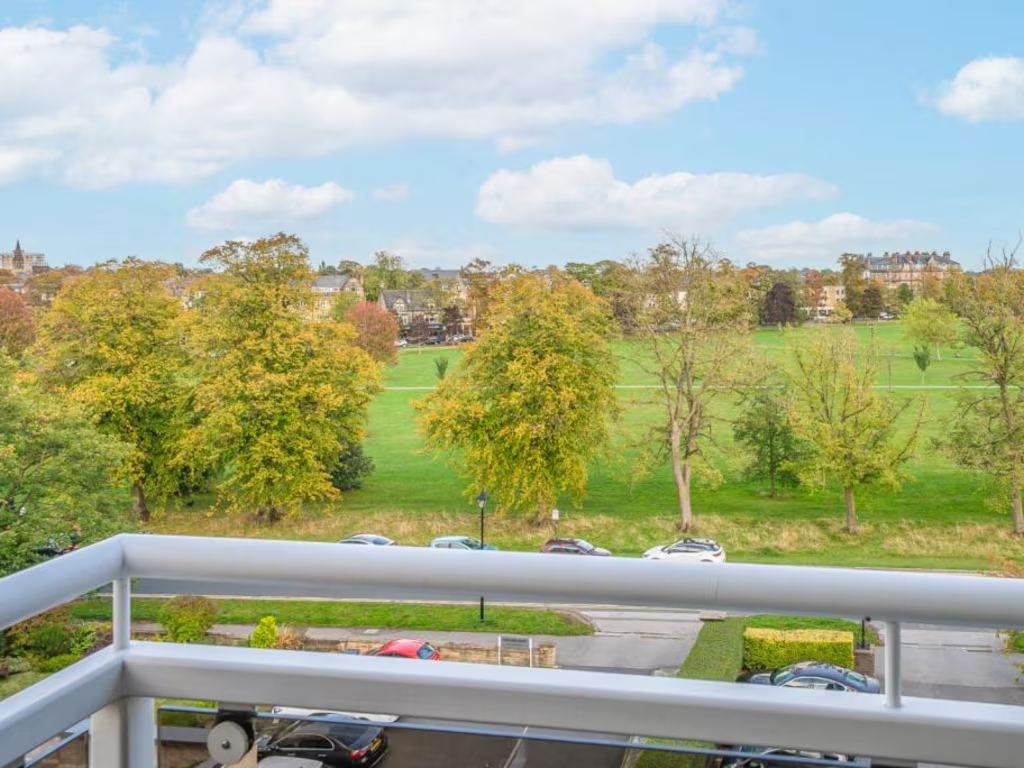
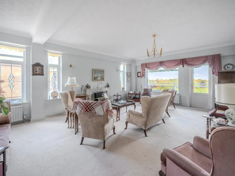
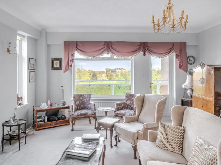
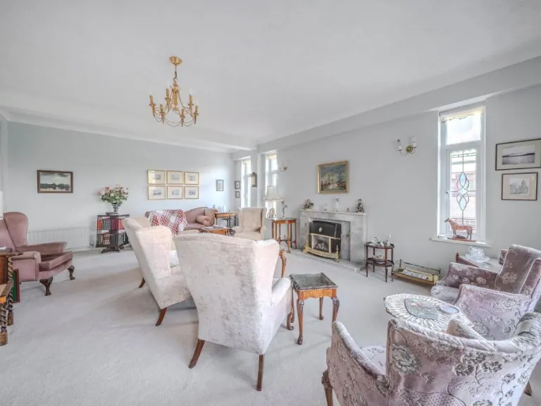
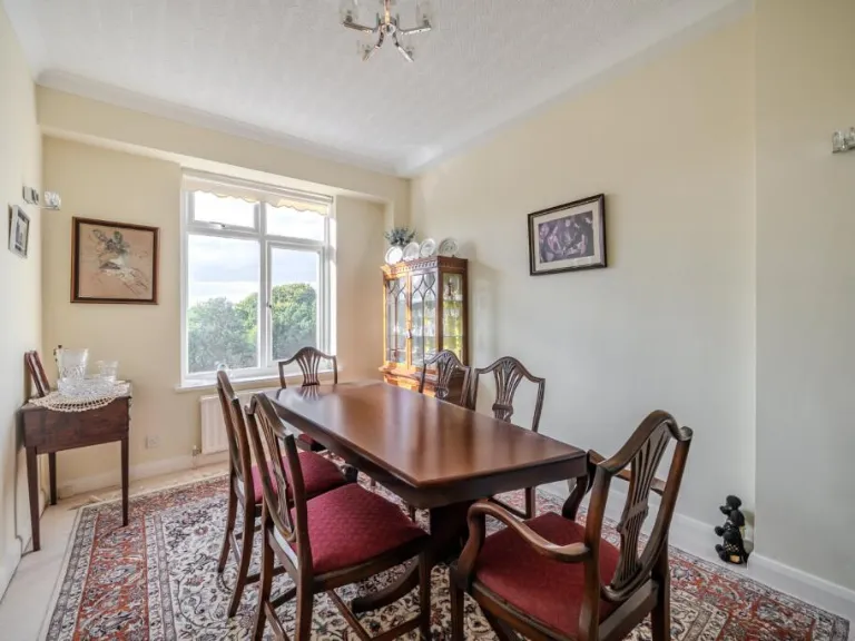
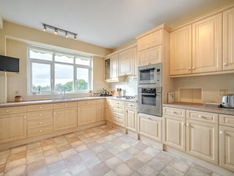
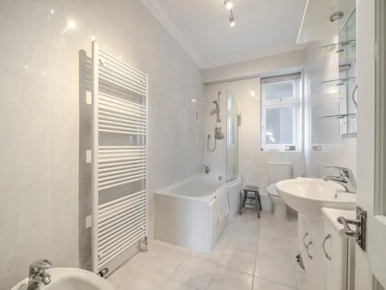
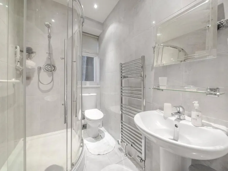
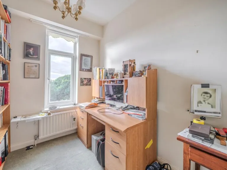
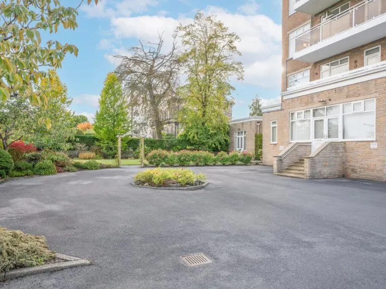
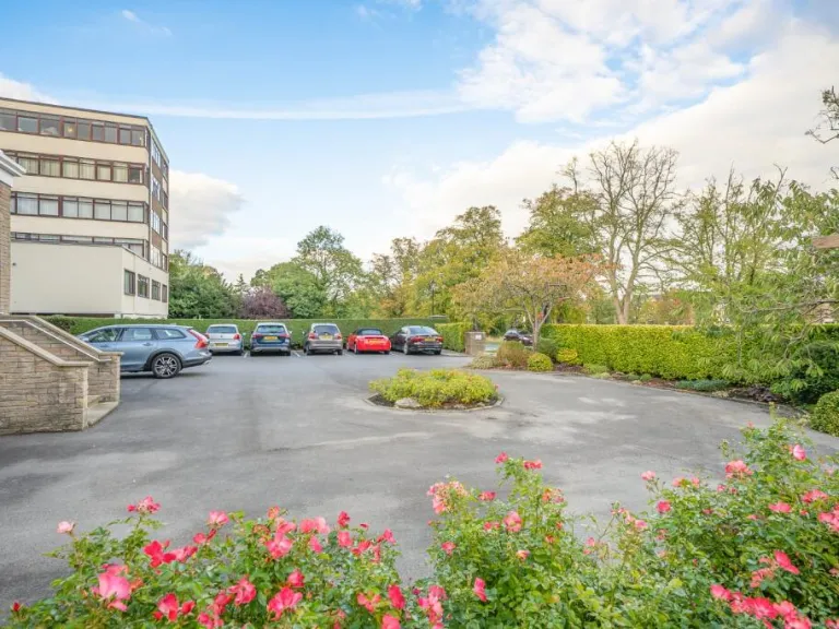
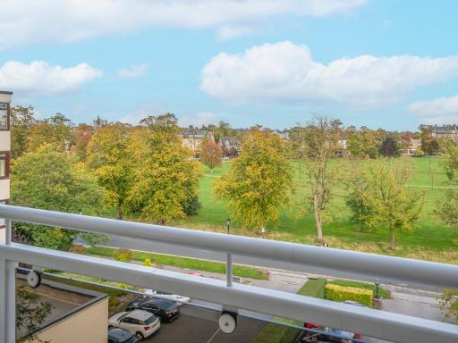
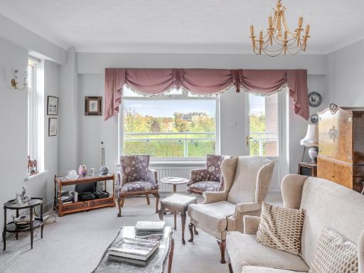
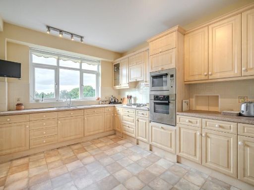
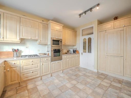
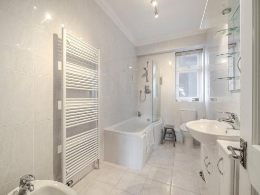
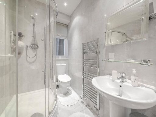
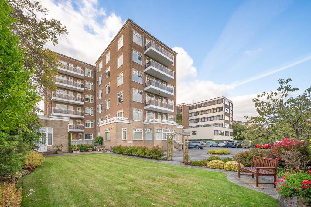
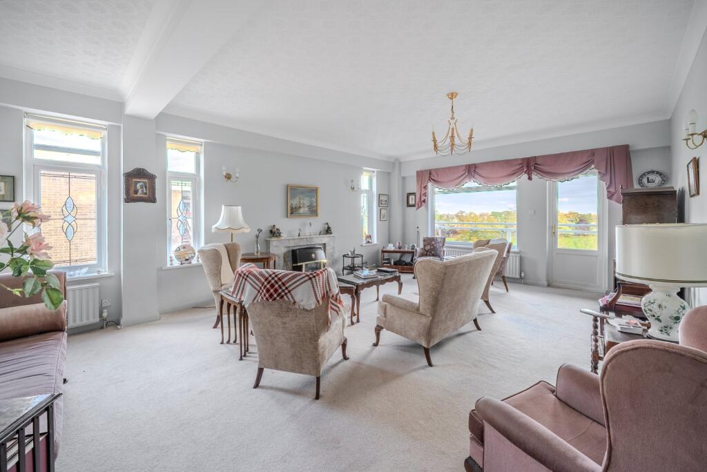
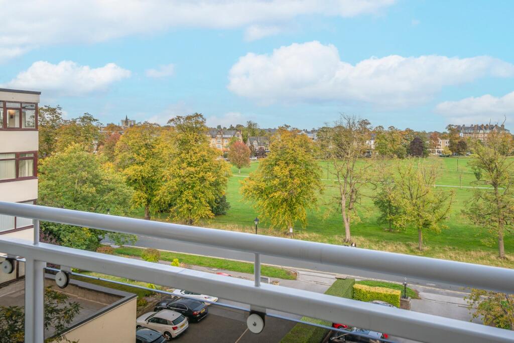
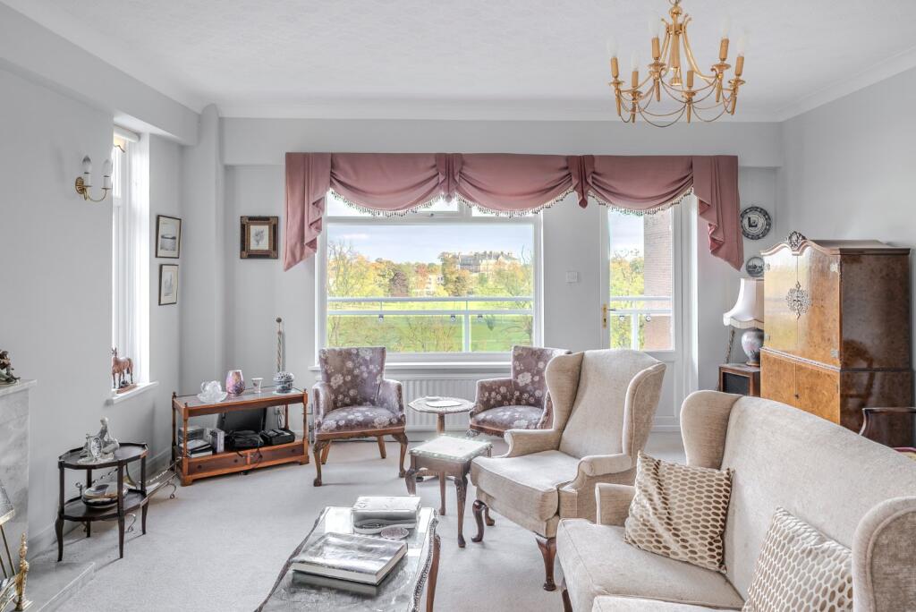
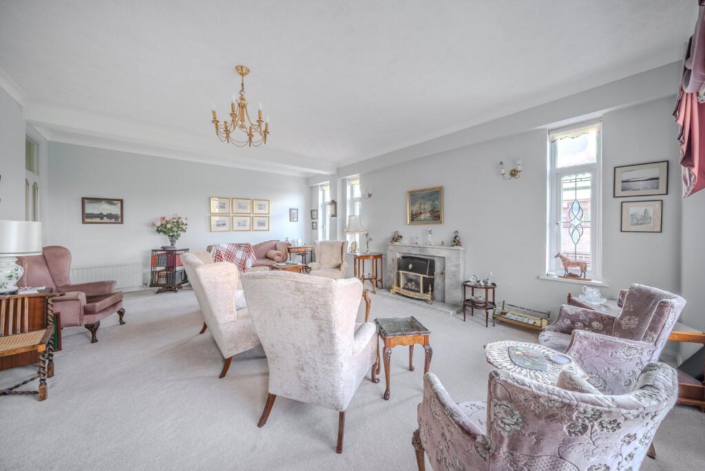
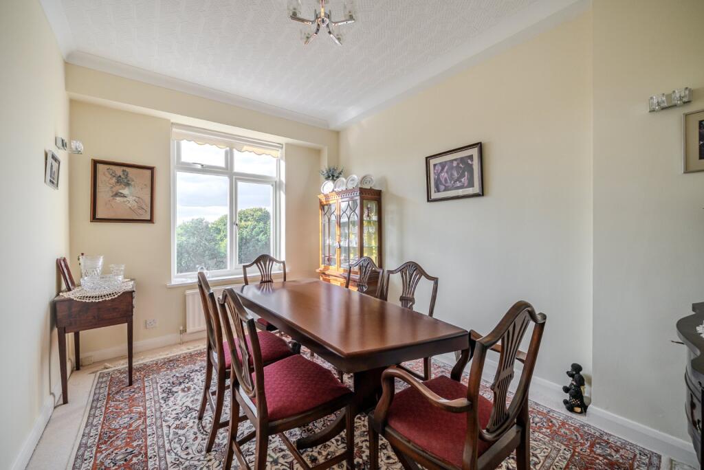
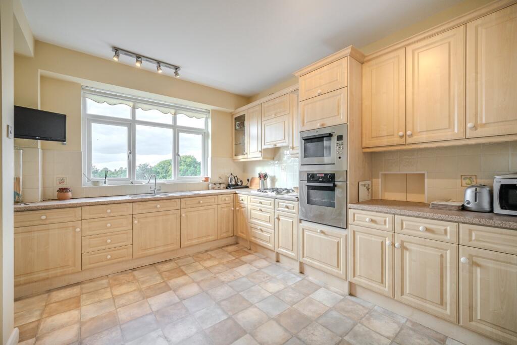
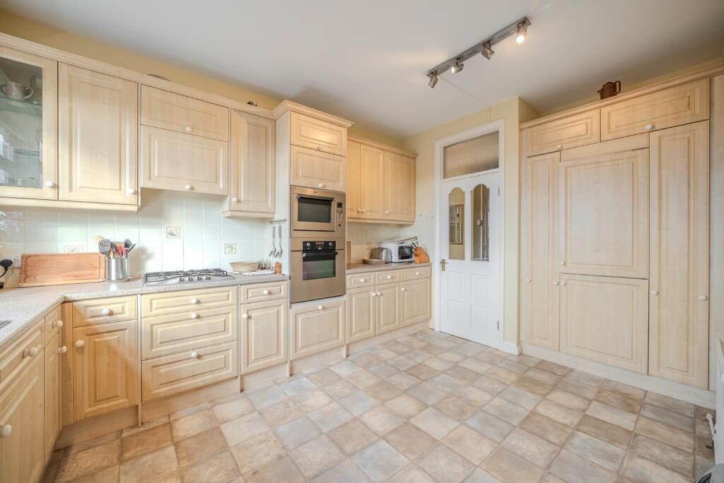
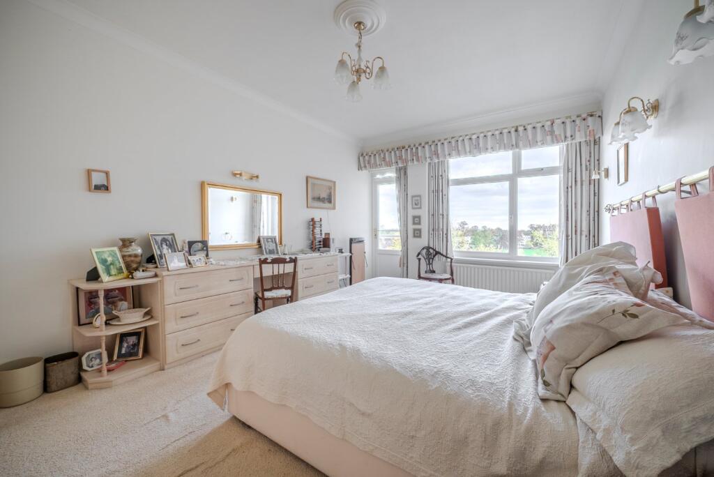
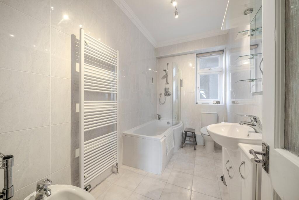
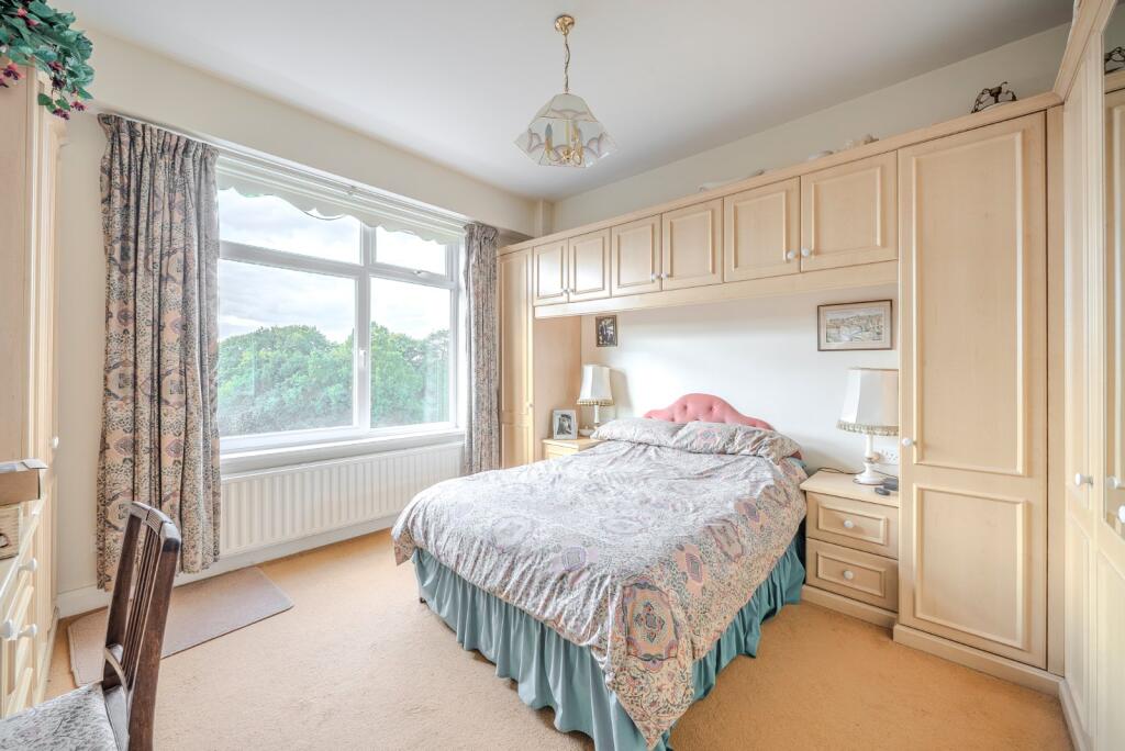
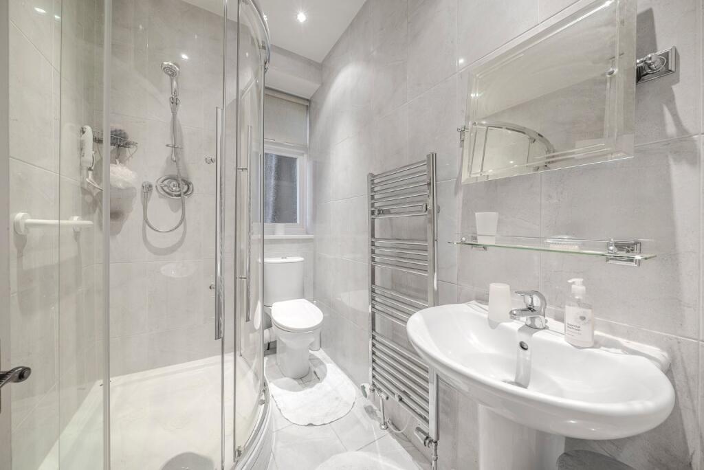
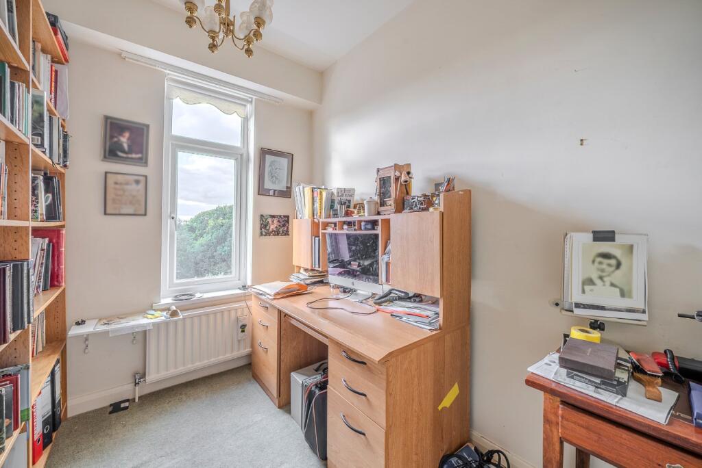
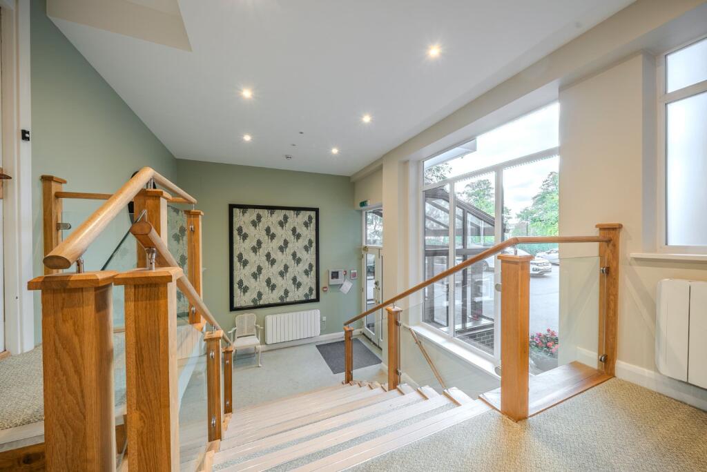
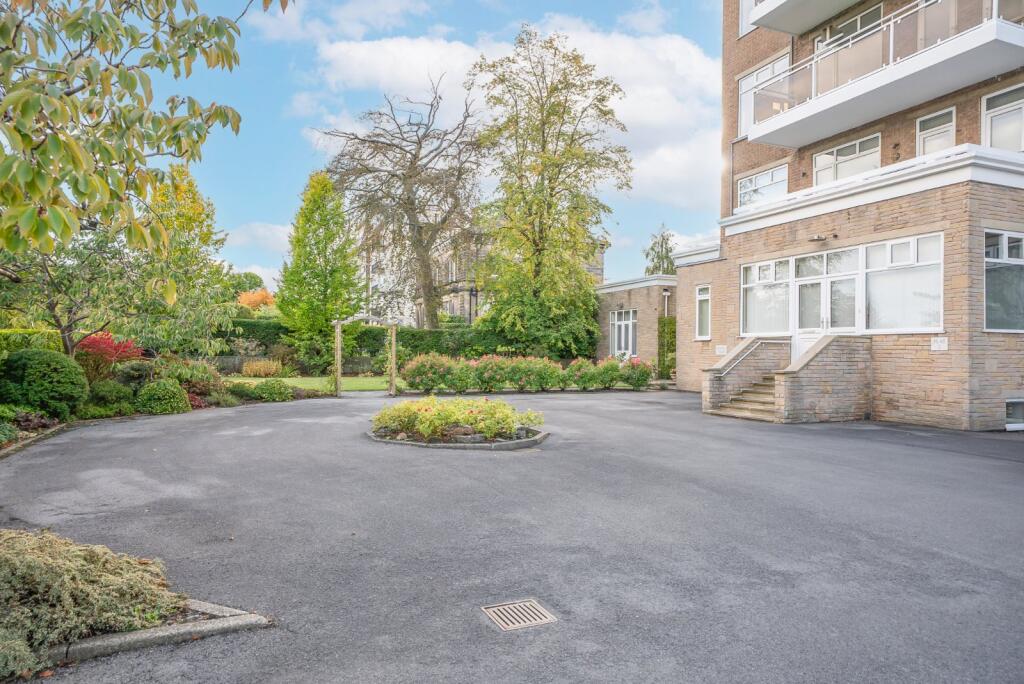
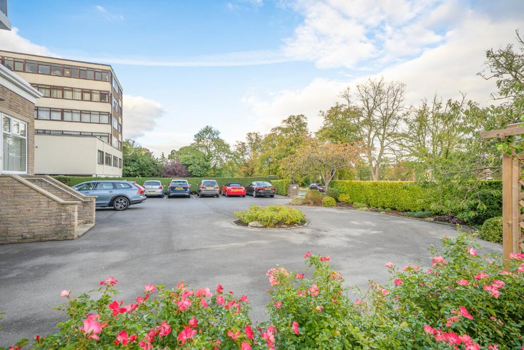
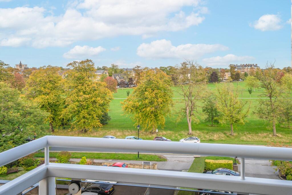
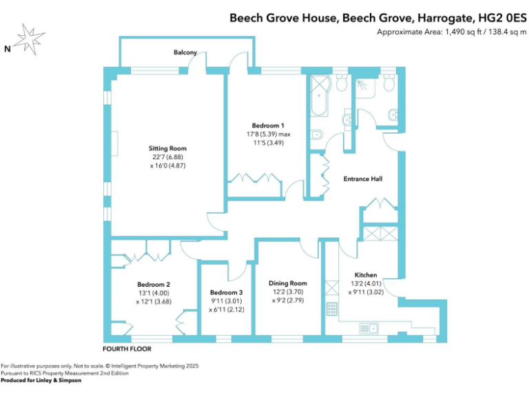
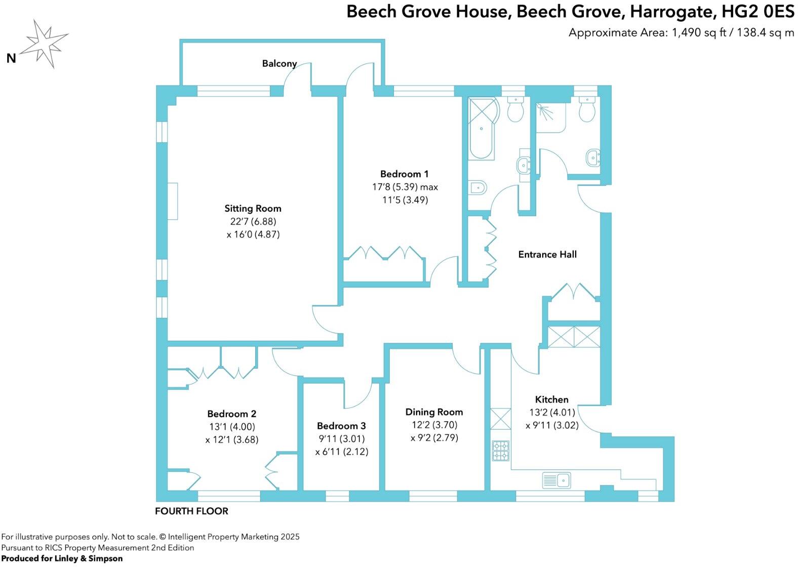
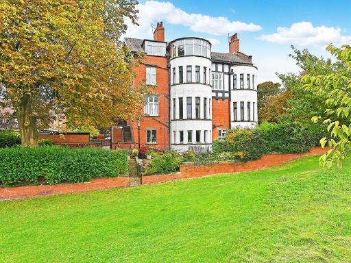
- Purpose-built, higher-floor apartment within a substantial brick-built block set in well-maintained communal grounds. The floorplan shows a large reception/sitting room with balcony, a separate kitchen/breakfast area, multiple bedrooms and two bathrooms (suite and separate bathroom), plus hallway storage. The property benefits from communal gardens, resident parking and far-reaching, elevated views from the balcony. Room sizes appear generous (particularly the main reception) indicating a spacious apartment footprint. Overall the apartment would be described as a large, well-proportioned flat in a mature development, suitable for downsizers or professionals wanting central Harrogate location and communal amenities.
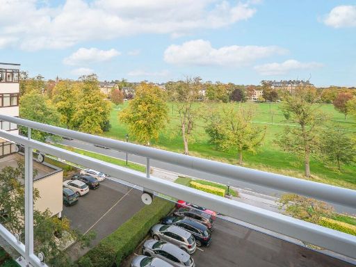
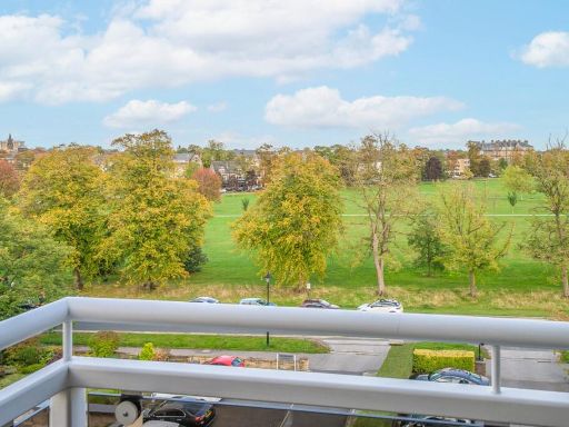
- Generously sized purpose-built apartment in a well-maintained development with attractive communal gardens and views across The Stray towards West Park and Harrogate town centre. The property is presented as a dual-aspect apartment with an impressive, large lounge opening via French doors onto a private balcony with open, far-reaching views. Accommodation includes a separate dining room, breakfast/kitchen with integrated appliances, three well-sized bedrooms and a modern bathroom, together with a guest cloakroom off the entrance hall. Ancillary space comprises a dedicated basement storage room and a single garage with light and electricity to the rear of the building. Parking to the front is on a first-come, first-served basis. Overall the apartment offers spacious living rooms (large lounge and separate dining) and comfortable bedroom accommodation (average/large bedrooms) — a substantial apartment suitable for town-centre living with exceptional views and convenient communal amenities.
Image Descriptions
- apartment building Mid-20th Century
- living room traditional
Floorplan Description
- Fourth floor flat with sitting room, three bedrooms, dining room and kitchen.
Rooms
- Sitting Room:
- Bedroom 1:
- Bedroom 2:
- Bedroom 3:
- Dining Room:
- Kitchen:
Textual Property Features
Detected Visual Features
- apartment building
- brick
- mid-20th century
- balconies
- communal garden
- parking lot
- urban
- low maintenance
- landscape
- traditional interior
- living room
- fireplace
- coving
- dual aspect windows
- chandelier
- potential for modernisation
- bright
- open view
EPC Details
- Fully double glazed
- System built, as built, no insulation (assumed)
- Boiler and radiators, mains gas
- Low energy lighting in 56% of fixed outlets
- (another dwelling below)
Nearby Schools
- St Robert's Catholic Primary School, A Voluntary Academy
- St Joseph's Catholic Primary School, Harrogate, A Voluntary Academy
- Saltergate Community Junior School
- New Park Primary Academy
- Richard Taylor Church of England Primary School
- Rossett School
- Oatlands Community Junior School
- Oatlands Infant School
- Harrogate Grammar School
- St John Fisher Catholic Academy
- Harrogate High School
- Harrogate, Grove Road Community Primary School
- Coppice Valley Primary School
- Harrogate, Bilton Grange Primary School
- Killinghall Church of England Primary School
- Ashville College
- Rossett Acre Primary School
- Brackenfield School
- Harrogate Ladies' College
- Pannal Primary School
- Beckwithshaw Community Primary School
- St Aidan's Church of England High School
- St Peter's Church of England Primary School
- Starbeck Primary Academy
- Saltergate Infant School
- Western Primary School
- Willow Tree Community Primary School
Nearest Bars And Restaurants
- Id: 7092264757
- Tags:
- Amenity: pub
- Name: Last Post
- Old_name: Slip Inn
- TagsNormalized:
- Lat: 53.9904736
- Lon: -1.5477533
- FullGeoHash: gcwghu8vq9z2
- PartitionGeoHash: gcwg
- Images:
- FoodStandards: null
- Distance: 301.9
,- Id: 3011319449
- Tags:
- Addr:
- City: Harrogate
- Housenumber: 34
- Postcode: HG2 0NA
- Street: Cold Bath Road
- Amenity: restaurant
- Cuisine: fish_and_chips
- Name: Oliver's Fish and Chips
- Note: Eatin or Take Away
- Opening_hours: Tu-Su 12:30-14:30,17:00-22:00
- Phone: +44 20 7586 9945
- Source: Local Visits and Google
- TagsNormalized:
- Lat: 53.9901365
- Lon: -1.547905
- FullGeoHash: gcwghu8g74ym
- PartitionGeoHash: gcwg
- Images:
- FoodStandards: null
- Distance: 288.9
,- Id: 7092264756
- Tags:
- Amenity: cafe
- Name: Tilly Peppers
- TagsNormalized:
- Lat: 53.9903882
- Lon: -1.5473532
- FullGeoHash: gcwghu9kb1cf
- PartitionGeoHash: gcwg
- Images:
- FoodStandards: null
- Distance: 275.6
,- Id: 5353360726
- Tags:
- Amenity: pub
- Name: The Coach and Horses
- Website: http://www.thecoachandhorses.net/
- TagsNormalized:
- Lat: 53.9888374
- Lon: -1.540284
- FullGeoHash: gcwghuq7ub9p
- PartitionGeoHash: gcwg
- Images:
- FoodStandards: null
- Distance: 250.4
,- Id: 3124715223
- Tags:
- Addr:
- Housenumber: 11
- Street: West Park
- Amenity: restaurant
- Name: Three's a Crowd
- Old_name: Muckles
- TagsNormalized:
- Lat: 53.9892507
- Lon: -1.5406134
- FullGeoHash: gcwghuqnjjg3
- PartitionGeoHash: gcwg
- Images:
- FoodStandards: null
- Distance: 234.2
}
Nearest General Shops
- Id: 291296521
- Tags:
- Brand: Cotswold Outdoor
- Brand:wikidata: Q5175488
- Brand:wikipedia: en:Cotswold Outdoor
- Building: retail
- Contact:
- Website: https://www.cotswoldoutdoor.com/stores/harrogate.html
- Name: Cotswold Outdoor
- Shop: outdoor
- TagsNormalized:
- cotswold outdoor
- outdoor
- retail
- shop
- Lat: 53.9894618
- Lon: -1.5400531
- FullGeoHash: gcwghuqx6jjh
- PartitionGeoHash: gcwg
- Images:
- FoodStandards: null
- Distance: 275.4
,- Id: 287884359
- Tags:
- Building: retail
- Name: Specialized Harrogate
- Shop: bicycle
- TagsNormalized:
- Lat: 53.9895981
- Lon: -1.540507
- FullGeoHash: gcwghuw0pwd9
- PartitionGeoHash: gcwg
- Images:
- FoodStandards: null
- Distance: 251.8
,- Id: 428094280
- Tags:
- Building: retail
- Name: Oka
- Shop: interiors
- TagsNormalized:
- Lat: 53.9894867
- Lon: -1.5404566
- FullGeoHash: gcwghuqr8cb2
- PartitionGeoHash: gcwg
- Images:
- FoodStandards: null
- Distance: 250.9
}
Nearest Grocery shops
- Id: 3254139279
- Tags:
- Addr:
- Postcode: HG1 1NS
- Street: Cambridge Road
- Alt_name: Tesco Cambridge Road Harrogate Express
- Brand: Tesco Express
- Brand:wikidata: Q98456772
- Brand:wikipedia: en:Tesco
- Contact:
- Website: https://www.tesco.com/store-locator/harrogate/cambridge-rd
- Name: Tesco Express
- Shop: convenience
- TagsNormalized:
- tesco
- tesco express
- convenience
- shop
- Lat: 53.9935737
- Lon: -1.5411528
- FullGeoHash: gcwghvjz2e9h
- PartitionGeoHash: gcwg
- Images:
- FoodStandards: null
- Distance: 564.7
,- Id: 319002611
- Tags:
- Addr:
- Housenumber: 23-24
- Postcode: HG1 1BJ
- Street: West Park
- Building: yes
- Name: Weetons Food Hall
- Shop: supermarket
- TagsNormalized:
- Lat: 53.9882965
- Lon: -1.5396507
- FullGeoHash: gcwghuqbeecj
- PartitionGeoHash: gcwg
- Images:
- FoodStandards: null
- Distance: 297.1
,- Id: 297420681
- Tags:
- Addr:
- City: Harrogate
- Housenumber: 111
- Postcode: HG2 0NU
- Street: Cold Bath Road
- Alt_name: Sainsbury's Cold Bath Road Local
- Brand: Sainsbury's Local
- Brand:wikidata: Q13218434
- Building: retail
- Name: Sainsbury's Local
- Operator: Sainsbury's
- Phone: +44 1423 504484
- Shop: convenience
- TagsNormalized:
- sainsburys
- sainsburys local
- retail
- convenience
- shop
- Lat: 53.9895843
- Lon: -1.5481812
- FullGeoHash: gcwghu88hgbr
- PartitionGeoHash: gcwg
- Images:
- FoodStandards: null
- Distance: 279.8
}
Nearest Supermarkets
- Id: 167261484
- Tags:
- Addr:
- City: Harrogate
- Country: GB
- Postcode: HG1 5DE
- Street: Bower Road
- Alt_name: ASDA Harrogate Superstore
- Brand: Asda
- Brand:wikidata: Q297410
- Brand:wikipedia: en:Asda
- Building: supermarket
- Fhrs:
- Name: Asda
- Operator: Asda Stores Ltd
- Shop: supermarket
- Website: https://storelocator.asda.com/yorkshire-&-humber/harrogate/bower-road
- TagsNormalized:
- Lat: 53.9961452
- Lon: -1.5361284
- FullGeoHash: gcwgjj9qme58
- PartitionGeoHash: gcwg
- Images:
- FoodStandards:
- Id: 224089
- FHRSID: 224089
- LocalAuthorityBusinessID: PI/000000977
- BusinessName: Asda
- BusinessType: Retailers - supermarkets/hypermarkets
- BusinessTypeID: 7840
- AddressLine1: Bower Road
- AddressLine2: Harrogate
- AddressLine3: North Yorkshire
- AddressLine4: null
- PostCode: HG1 5DE
- RatingValue: 5
- RatingKey: fhrs_5_en-GB
- RatingDate: 2019-03-11
- LocalAuthorityCode: 252
- LocalAuthorityName: Harrogate
- LocalAuthorityWebSite: http://www.harrogate.gov.uk
- LocalAuthorityEmailAddress: foodandoccupationalsafety@harrogate.gov.uk
- Scores:
- Hygiene: 5
- Structural: 0
- ConfidenceInManagement: 0
- NewRatingPending: false
- Geocode:
- Longitude: -1.53658500000000
- Latitude: 53.99608300000000
- Distance: 969.1
,- Id: 361427541
- Tags:
- Addr:
- Brand: Co-op Food
- Brand:wikidata: Q3277439
- Brand:wikipedia: en:Co-op Food
- Building: yes
- Name: Co-op Food
- Operator: The Co-operative Group
- Operator:wikidata: Q117202
- Shop: supermarket
- TagsNormalized:
- co-op
- co-op food
- food
- supermarket
- shop
- Lat: 53.9840994
- Lon: -1.5508594
- FullGeoHash: gcwghew8nme2
- PartitionGeoHash: gcwg
- Images:
- FoodStandards: null
- Distance: 684.1
,- Id: 178726375
- Tags:
- Addr:
- Housenumber: 92
- Postcode: HG1 1HD
- Street: Station Parade
- Alt_name: Waitrose Harrogate
- Brand: Waitrose
- Brand:wikidata: Q771734
- Brand:wikipedia: en:Waitrose & Partners
- Building: supermarket
- Name: Waitrose
- Official_name: Waitrose & Partners
- Operator: Waitrose & Partners
- Shop: supermarket
- TagsNormalized:
- Lat: 53.9899155
- Lon: -1.5362539
- FullGeoHash: gcwgjh9649wn
- PartitionGeoHash: gcwg
- Images:
- FoodStandards: null
- Distance: 528.5
}
Nearest Religious buildings
- Id: 211489912
- Tags:
- Addr:
- City: Harrogate
- Postcode: HG1 1EL
- Street: Victoria Avenue
- Amenity: place_of_worship
- Building: church
- Denomination: united_reformed
- Name: St Paul's United Reformed Church
- Religion: christian
- TagsNormalized:
- place of worship
- church
- united reformed
- christian
- Lat: 53.9903569
- Lon: -1.5386722
- FullGeoHash: gcwghuxsd7fz
- PartitionGeoHash: gcwg
- Images:
- FoodStandards: null
- Distance: 395.5
,- Id: 211408109
- Tags:
- Amenity: place_of_worship
- Building: church
- Denomination: united_reformed
- Name: West Park URC Church
- Religion: christian
- Wikidata: Q7986175
- Wikipedia: en:West Park United Reformed Church, Harrogate
- TagsNormalized:
- place of worship
- church
- united reformed
- christian
- Lat: 53.990708
- Lon: -1.540497
- FullGeoHash: gcwghuwnxv6n
- PartitionGeoHash: gcwg
- Images:
- FoodStandards: null
- Distance: 317.5
,- Id: 3978049917
- Tags:
- Amenity: place_of_worship
- Denomination: orthodox
- Name: Harrogate Synagogue
- Religion: jewish
- TagsNormalized:
- place of worship
- orthodox
- synagogue
- jewish
- Lat: 53.991404
- Lon: -1.5446549
- FullGeoHash: gcwghug4wzjy
- PartitionGeoHash: gcwg
- Images:
- FoodStandards: null
- Distance: 291.5
}
Nearest Medical buildings
- Id: 7528773067
- Tags:
- Addr:
- City: Harrogate
- Housenumber: 26-28
- Postcode: HG1 1RX
- Street: Cambridge Street
- Amenity: pharmacy
- Brand: Boots
- Brand:wikidata: Q6123139
- Brand:wikipedia: en:Boots (company)
- Healthcare: pharmacy
- Name: Boots
- Note: is in Boots Chemist
- TagsNormalized:
- pharmacy
- boots
- health
- healthcare
- Lat: 53.9934383
- Lon: -1.5399826
- FullGeoHash: gcwghvnwef3t
- PartitionGeoHash: gcwg
- Images:
- FoodStandards: null
- Distance: 581.9
,- Id: 7528773066
- Tags:
- Addr:
- City: Harrogate
- Housenumber: 1
- Postcode: HG1 1NS
- Street: Cambridge Road
- Amenity: pharmacy
- Brand: Superdrug
- Brand:wikidata: Q7643261
- Brand:wikipedia: en:Superdrug
- Healthcare: pharmacy
- Name: Superdrug
- Note: is in Superdrug
- TagsNormalized:
- pharmacy
- superdrug
- health
- healthcare
- Lat: 53.9934557
- Lon: -1.5410445
- FullGeoHash: gcwghvjyej9u
- PartitionGeoHash: gcwg
- Images:
- FoodStandards: null
- Distance: 555
,- Id: 377140695
- Tags:
- Addr:
- City: Harrogate
- Housenumber: 111
- Postcode: HG2 0NU
- Street: Cold Bath Road
- Amenity: pharmacy
- Building: yes
- Healthcare: pharmacy
- Name: Co-operative
- Phone: +44 1423 504484
- TagsNormalized:
- Lat: 53.9891771
- Lon: -1.5485978
- FullGeoHash: gcwghu2mg01f
- PartitionGeoHash: gcwg
- Images:
- FoodStandards: null
- Distance: 296.1
,- Id: 165756017
- Tags:
- Amenity: hospital
- Building: hospital
- Emergency: no
- Healthcare: hospital
- Name: Duchy Hospital
- Source: Local Knowlege
- Wikidata: Q30265240
- TagsNormalized:
- Lat: 53.9876034
- Lon: -1.5479096
- FullGeoHash: gcwghu0ue4dy
- PartitionGeoHash: gcwg
- Images:
- FoodStandards: null
- Distance: 281.7
}
Nearest Airports
- Id: 11519546
- Tags:
- Addr:
- City: Leeds
- Postcode: LS19 7TU
- Aerodrome: international
- Aerodrome:type: public
- Aeroway: aerodrome
- Iata: LBA
- Icao: EGNM
- Name: Leeds Bradford Airport
- Operator: Leeds Bradford Airport Limited
- Operator:type: private
- Ref: LBA
- Type: multipolygon
- Website: https://www.leedsbradfordairport.co.uk/
- Wikidata: Q8699
- Wikipedia: en:Leeds Bradford Airport
- TagsNormalized:
- airport
- international airport
- Lat: 53.8667047
- Lon: -1.660138
- FullGeoHash: gcwf6nph7cx3
- PartitionGeoHash: gcwf
- Images:
- Q8699-1
- Q8699-2
- Q8699-3
- Q8699-4
- FoodStandards: null
- Distance: 15557.3
}
Nearest Leisure Facilities
- Id: 130036688
- Tags:
- TagsNormalized:
- Lat: 53.9871325
- Lon: -1.5392771
- FullGeoHash: gcwghup1u4zv
- PartitionGeoHash: gcwg
- Images:
- FoodStandards: null
- Distance: 366.7
,- Id: 130036687
- Tags:
- Leisure: garden
- Name: West Park Gardens
- TagsNormalized:
- Lat: 53.9911633
- Lon: -1.5413836
- FullGeoHash: gcwghuv974m4
- PartitionGeoHash: gcwg
- Images:
- FoodStandards: null
- Distance: 317.4
,- Id: 37104547
- Tags:
- Leisure: park
- Name: The Stray West Park
- TagsNormalized:
- Lat: 53.9913453
- Lon: -1.5431682
- FullGeoHash: gcwghuu63s4r
- PartitionGeoHash: gcwg
- Images:
- FoodStandards: null
- Distance: 289.4
,- Id: 130036698
- Tags:
- Leisure: garden
- Name: West Park Gardens
- TagsNormalized:
- Lat: 53.9906397
- Lon: -1.5411382
- FullGeoHash: gcwghuty2bsn
- PartitionGeoHash: gcwg
- Images:
- FoodStandards: null
- Distance: 282.1
,- Id: 4438856
- Tags:
- Leisure: park
- Name: The Stray or Two Hundred Acre
- TagsNormalized:
- Lat: 53.9880562
- Lon: -1.5419193
- FullGeoHash: gcwghujpnxje
- PartitionGeoHash: gcwg
- Images:
- FoodStandards: null
- Distance: 165.7
}
Nearest Tourist attractions
- Id: 10266066561
- Tags:
- Addr:
- City: Harrogate
- Housenumber: 28
- Postcode: HG1 1TY
- Street: Commercial Street
- Name: AC Gallery
- Tourism: gallery
- Website: https://www.acgallery.co.uk/harrogate
- TagsNormalized:
- Lat: 53.9954371
- Lon: -1.5391156
- FullGeoHash: gcwghvx60p00
- PartitionGeoHash: gcwg
- Images:
- FoodStandards: null
- Distance: 806.9
,- Id: 39017804
- Tags:
- Building: yes
- Name: Sun Pavilion
- Tourism: attraction
- TagsNormalized:
- pavilion
- attraction
- tourism
- Lat: 53.9921571
- Lon: -1.5513641
- FullGeoHash: gcwghsyr4ee4
- PartitionGeoHash: gcwg
- Images:
- FoodStandards: null
- Distance: 603.2
,- Id: 461982642
- Tags:
- Name: The Royal Pump Room Museum
- Tourism: museum
- Wikidata: Q7374742
- Wikipedia: en:Royal Pump Room, Harrogate
- TagsNormalized:
- Lat: 53.9935628
- Lon: -1.5468529
- FullGeoHash: gcwghv1x79wg
- PartitionGeoHash: gcwg
- Images:
- FoodStandards: null
- Distance: 558.8
}
Nearest Bus stations and stops
- Id: 9543598536
- Tags:
- Bus: yes
- Highway: bus_stop
- Local_ref: 1
- Name: Harrogate Bus Station (Stand 1)
- Public_transport: platform
- TagsNormalized:
- Lat: 53.9936209
- Lon: -1.5381817
- FullGeoHash: gcwghvpztu2w
- PartitionGeoHash: gcwg
- Images:
- FoodStandards: null
- Distance: 661.4
,- Id: 3055001679
- Tags:
- Bus: yes
- Highway: bus_stop
- Public_transport: platform
- TagsNormalized:
- Lat: 53.9912369
- Lon: -1.5373399
- FullGeoHash: gcwgjhb9c2h3
- PartitionGeoHash: gcwg
- Images:
- FoodStandards: null
- Distance: 519
,- Id: 9543852266
- Tags:
- Bus: yes
- Highway: bus_stop
- Public_transport: platform
- TagsNormalized:
- Lat: 53.9906965
- Lon: -1.538067
- FullGeoHash: gcwgjh8n87q1
- PartitionGeoHash: gcwg
- Images:
- FoodStandards: null
- Distance: 447.9
,- Id: 1562102243
- Tags:
- Bus: yes
- Highway: bus_stop
- Name: Pier Head
- Public_transport: platform
- TagsNormalized:
- Lat: 53.9923783
- Lon: -1.5423007
- FullGeoHash: gcwghvhbmuc1
- PartitionGeoHash: gcwg
- Images:
- FoodStandards: null
- Distance: 414.9
,- Id: 2376657576
- Tags:
- Bus: yes
- Highway: bus_stop
- Public_transport: platform
- TagsNormalized:
- Lat: 53.9877212
- Lon: -1.5396855
- FullGeoHash: gcwghunv68xm
- PartitionGeoHash: gcwg
- Images:
- FoodStandards: null
- Distance: 313.4
}
Nearest Hotels
- Id: 340935281
- Tags:
- Building: yes
- Name: The Yorkshire
- Tourism: hotel
- TagsNormalized:
- Lat: 53.992219
- Lon: -1.5413634
- FullGeoHash: gcwghuvx7xh5
- PartitionGeoHash: gcwg
- Images:
- FoodStandards: null
- Distance: 420.3
,- Id: 341779922
- Tags:
- Brand: Travelodge
- Brand:wikidata: Q9361374
- Brand:wikipedia: en:Travelodge UK
- Building: hotel
- Internet_access: wlan
- Internet_access:fee: customers
- Internet_access:ssid: Travelodge WiFi
- Name: Travelodge West Park
- Tourism: hotel
- TagsNormalized:
- Lat: 53.9891141
- Lon: -1.5388382
- FullGeoHash: gcwghurmqkr4
- PartitionGeoHash: gcwg
- Images:
- FoodStandards: null
- Distance: 346.6
,- Id: 462603208
- Tags:
- Name: Hotel du Vin
- Tourism: hotel
- TagsNormalized:
- Lat: 53.9911887
- Lon: -1.5409197
- FullGeoHash: gcwghuvcmznc
- PartitionGeoHash: gcwg
- Images:
- FoodStandards: null
- Distance: 337.6
}
Tags
- apartment building
- brick
- mid-20th century
- balconies
- communal garden
- parking lot
- urban
- low maintenance
- landscape
- traditional interior
- living room
- fireplace
- coving
- dual aspect windows
- chandelier
- potential for modernisation
- bright
- open view
Local Market Stats
- Average Price/sqft: £337
- Avg Income: £50600
- Rental Yield: 3.3%
- Social Housing: 7%
- Planning Success Rate: 92%
AirBnB Data
- 1km average: £107/night
- Listings in 1km: 29
Similar Properties
 3 bedroom apartment for sale in Leeds Road, Harrogate, HG2 — £660,000 • 3 bed • 1 bath • 1544 ft²
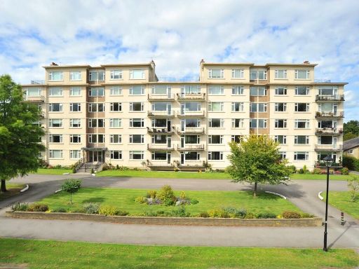 3 bedroom apartment for sale in Beech Grove Court, Beech Grove, Harrogate, HG2 — £700,000 • 3 bed • 2 bath • 1390 ft²
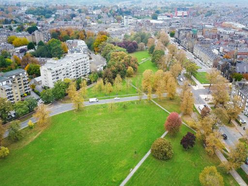 3 bedroom apartment for sale in Byron Court , Beech Grove, Harrogate, HG2 — £875,000 • 3 bed • 2 bath • 1588 ft²
 2 bedroom apartment for sale in Park Road, Harrogate, HG2 — £649,000 • 2 bed • 2 bath • 1778 ft²
 2 bedroom apartment for sale in Otley Road, Harrogate, HG2 — £425,000 • 2 bed • 1 bath • 1040 ft²
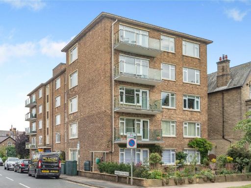 3 bedroom flat for sale in Princes Villa Road, Harrogate, North Yorkshire, HG1 — £700,000 • 3 bed • 2 bath • 1450 ft²
Meta
- {
"@context": "https://schema.org",
"@type": "Residence",
"name": "3 bedroom flat for sale in Beech Grove, Harrogate, North Yo…",
"description": "",
"url": "https://propertypiper.co.uk/property/98ab5dad-ca3a-447e-82dc-a3dddd059878",
"image": "https://image-a.propertypiper.co.uk/3c336d08-1c88-4174-ab73-f539bb5a3499-1024.jpeg",
"address": {
"@type": "PostalAddress",
"streetAddress": "BEECH GROVE HOUSE 16 BEECH GROVE HARROGATE ",
"postalCode": "HG2 0ES",
"addressLocality": "Harrogate",
"addressRegion": "Harrogate and Knaresborough",
"addressCountry": "England"
},
"geo": {
"@type": "GeoCoordinates",
"latitude": 53.9888023,
"longitude": -1.5441131
},
"numberOfRooms": 3,
"numberOfBathroomsTotal": 2,
"floorSize": {
"@type": "QuantitativeValue",
"value": 1490,
"unitCode": "FTK"
},
"offers": {
"@type": "Offer",
"price": 635000,
"priceCurrency": "GBP",
"availability": "https://schema.org/InStock"
},
"additionalProperty": [
{
"@type": "PropertyValue",
"name": "Feature",
"value": "apartment building"
},
{
"@type": "PropertyValue",
"name": "Feature",
"value": "brick"
},
{
"@type": "PropertyValue",
"name": "Feature",
"value": "mid-20th century"
},
{
"@type": "PropertyValue",
"name": "Feature",
"value": "balconies"
},
{
"@type": "PropertyValue",
"name": "Feature",
"value": "communal garden"
},
{
"@type": "PropertyValue",
"name": "Feature",
"value": "parking lot"
},
{
"@type": "PropertyValue",
"name": "Feature",
"value": "urban"
},
{
"@type": "PropertyValue",
"name": "Feature",
"value": "low maintenance"
},
{
"@type": "PropertyValue",
"name": "Feature",
"value": "landscape"
},
{
"@type": "PropertyValue",
"name": "Feature",
"value": "traditional interior"
},
{
"@type": "PropertyValue",
"name": "Feature",
"value": "living room"
},
{
"@type": "PropertyValue",
"name": "Feature",
"value": "fireplace"
},
{
"@type": "PropertyValue",
"name": "Feature",
"value": "coving"
},
{
"@type": "PropertyValue",
"name": "Feature",
"value": "dual aspect windows"
},
{
"@type": "PropertyValue",
"name": "Feature",
"value": "chandelier"
},
{
"@type": "PropertyValue",
"name": "Feature",
"value": "potential for modernisation"
},
{
"@type": "PropertyValue",
"name": "Feature",
"value": "bright"
},
{
"@type": "PropertyValue",
"name": "Feature",
"value": "open view"
}
]
}
High Res Floorplan Images
Compatible Floorplan Images
FloorplanImages Thumbnail