WR5 2HW - 5 bedroom detached house for sale in Battenhall Avenue, Wor…
View on Property Piper
5 bedroom detached house for sale in Battenhall Avenue, Worcester, Worcestershire, WR5
Property Details
- Price: £825000
- Bedrooms: 5
- Bathrooms: 3
- Property Type: undefined
- Property SubType: undefined
Brochure Descriptions
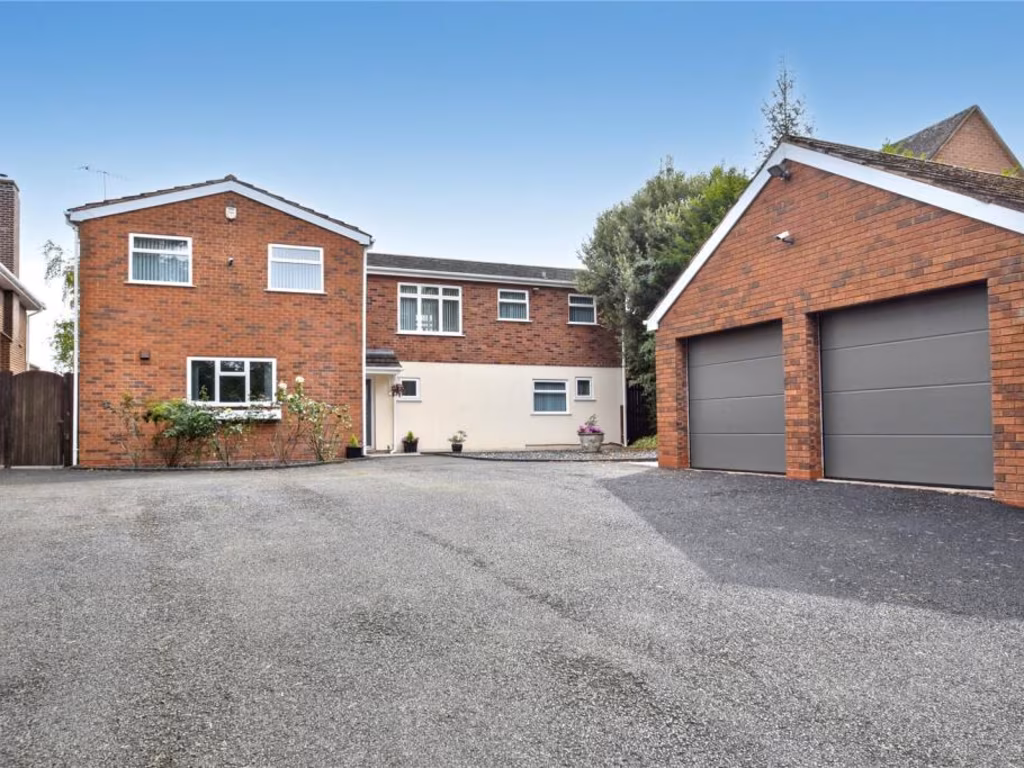
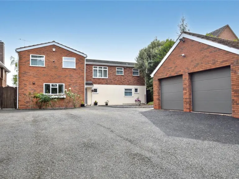
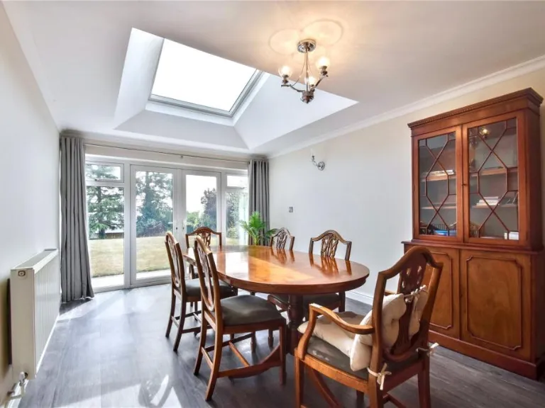
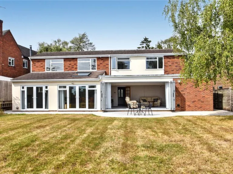
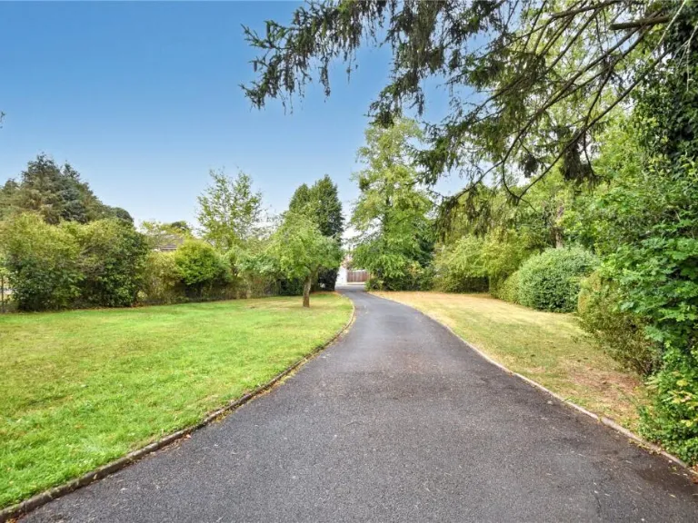
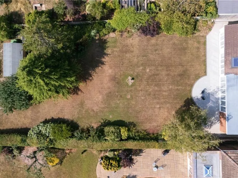
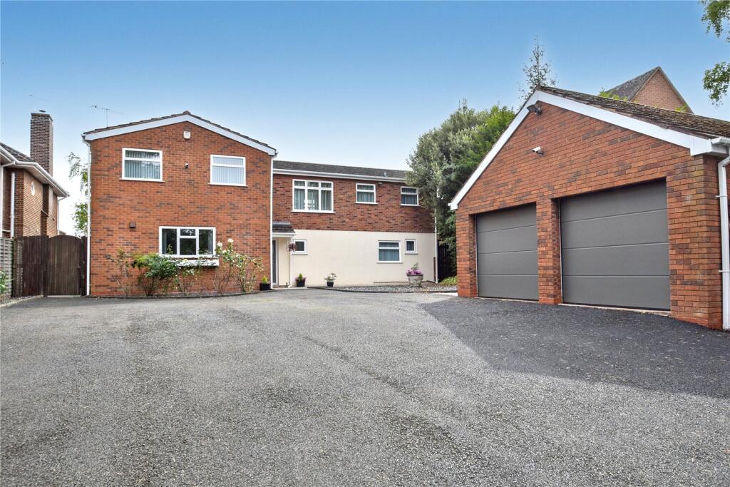
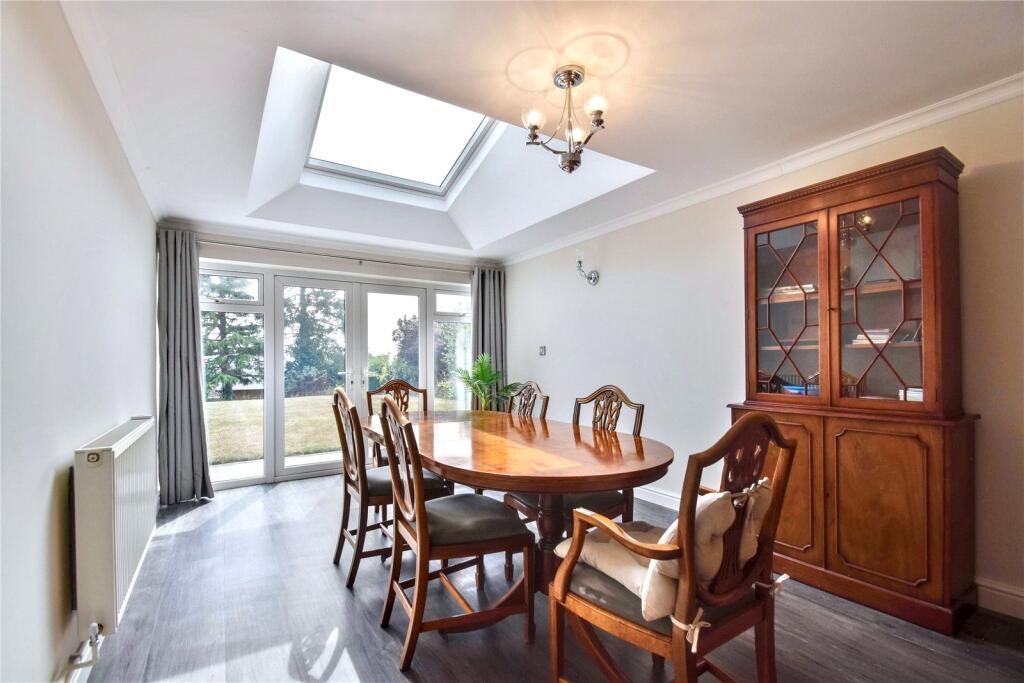
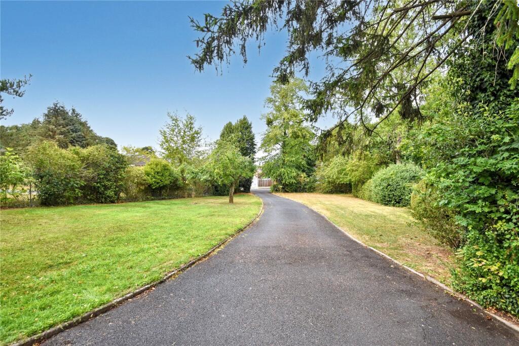
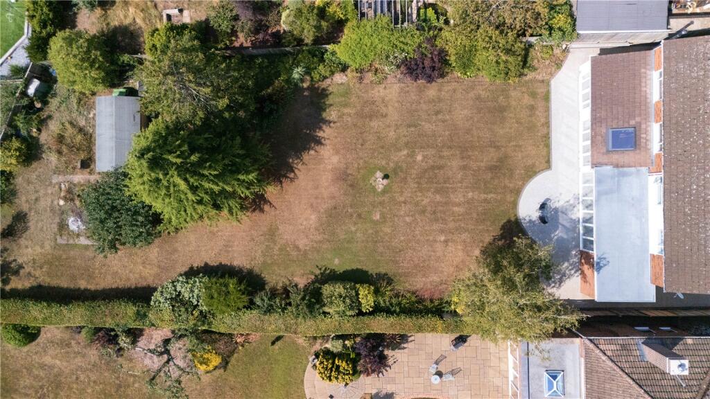
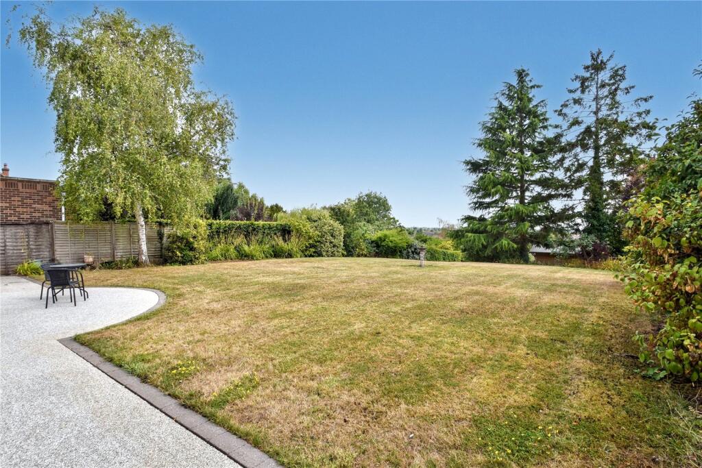
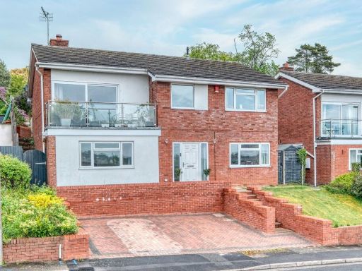
- Substantial detached two-storey brick residence with a large detached double garage and generous tarmac/gravel driveway providing extensive off‑street parking. The main house presents a traditional brick facade with a rendered ground-floor section and multiple uPVC windows. Likely accommodation footprint is generous given the width and depth of the building; suitable for a 4+ bedroom family home. Plot appears to be of medium-to-large size with potential mature planting immediately to the side/rear (partial tree screening visible) and scope for private rear garden. Overall condition externally appears well maintained; good curb appeal and high parking/garaging provision are strong value drivers. No exceptional views (city/river/sea) are evident from the images.
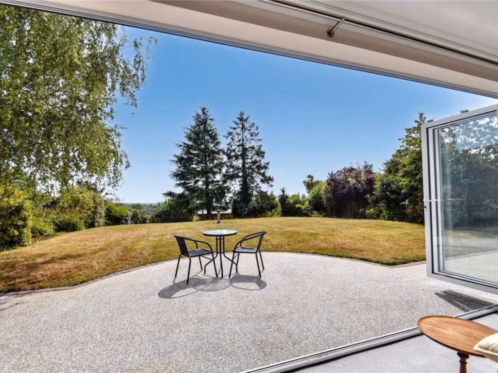
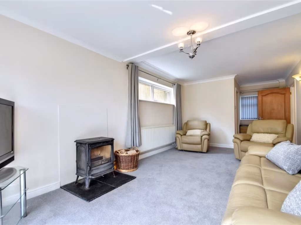
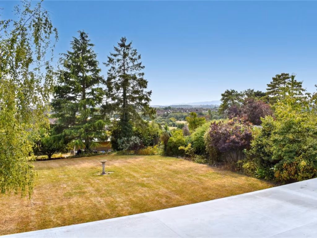
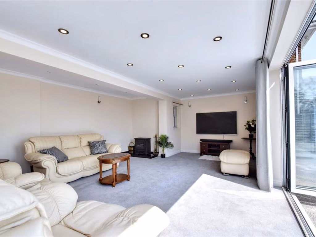
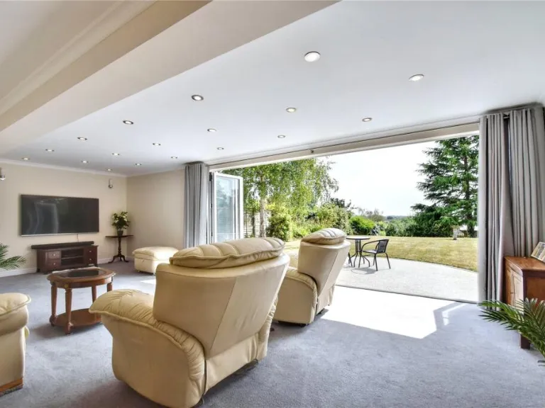
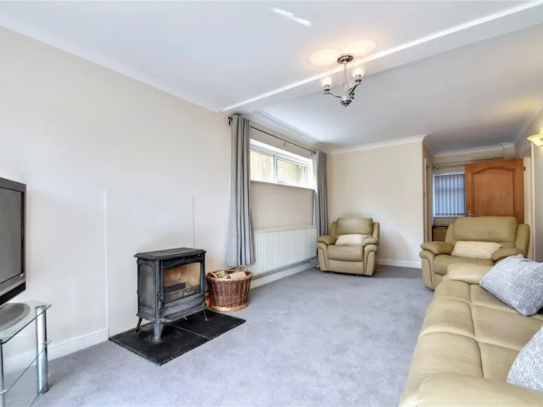
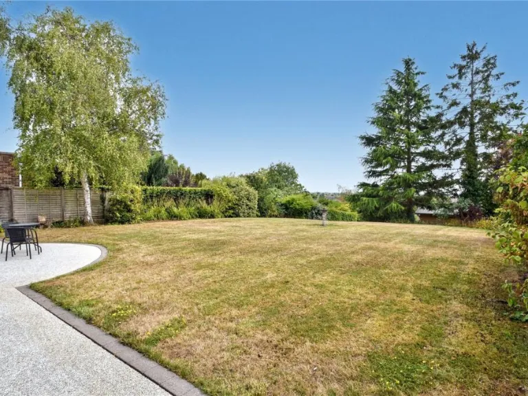
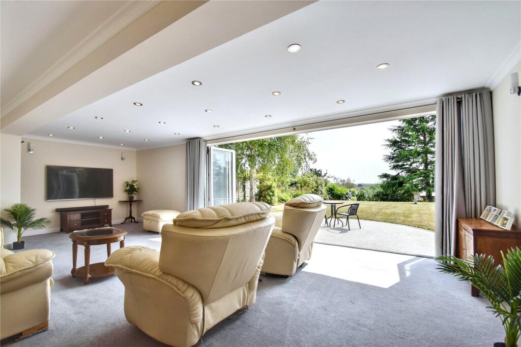
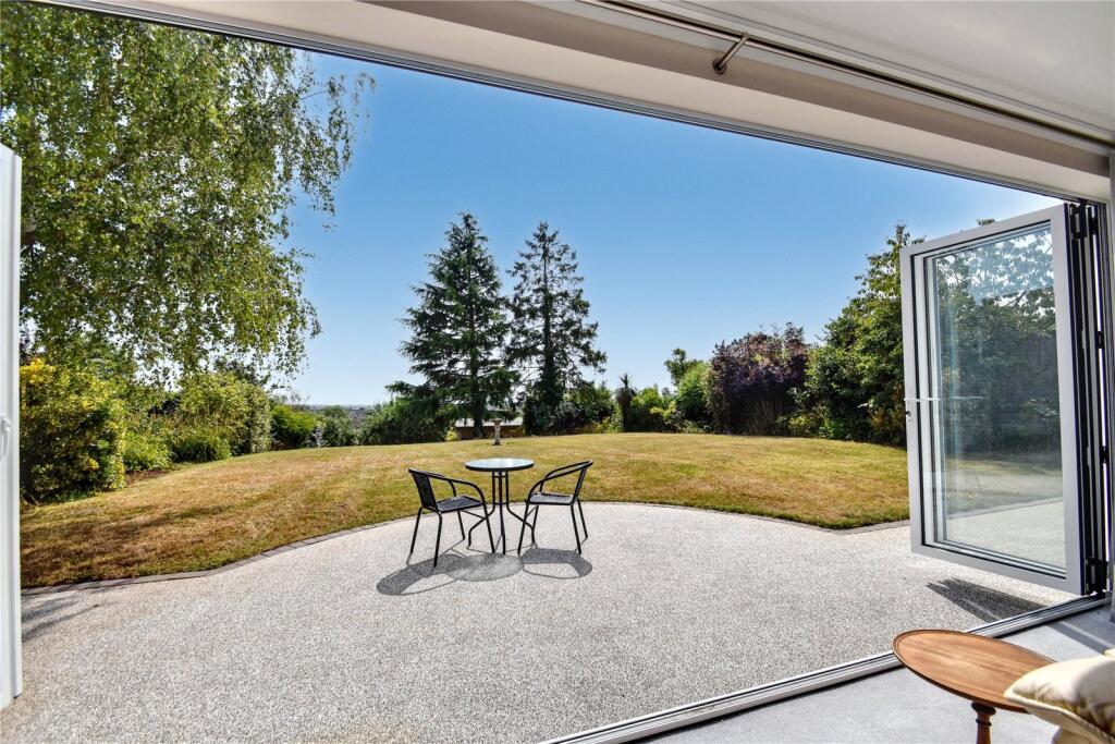
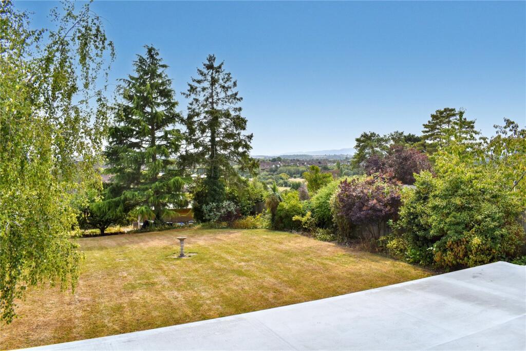
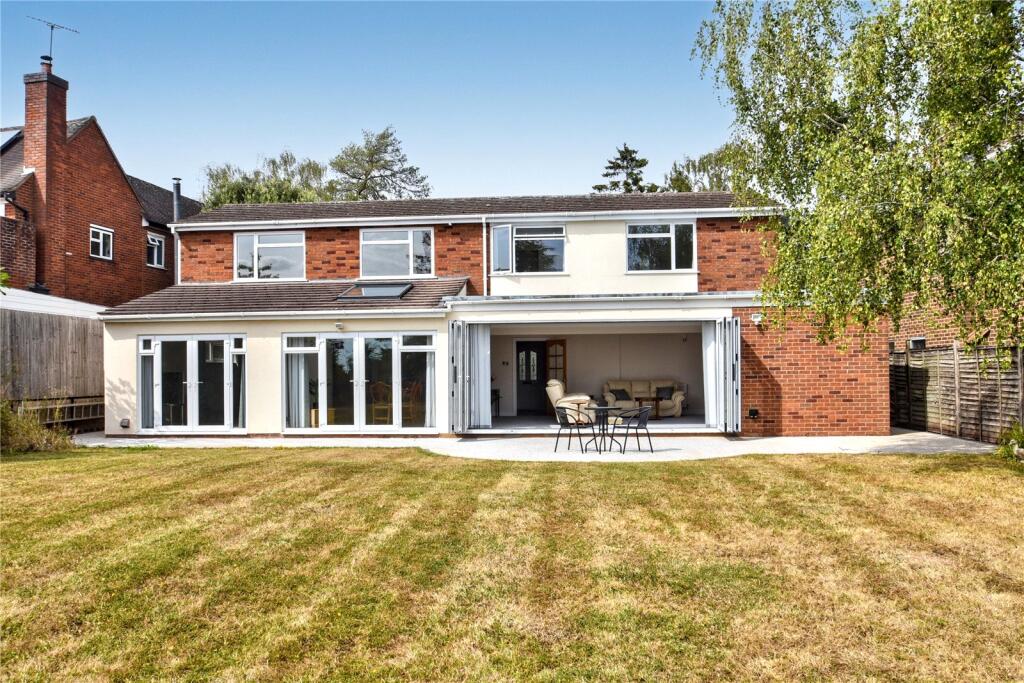
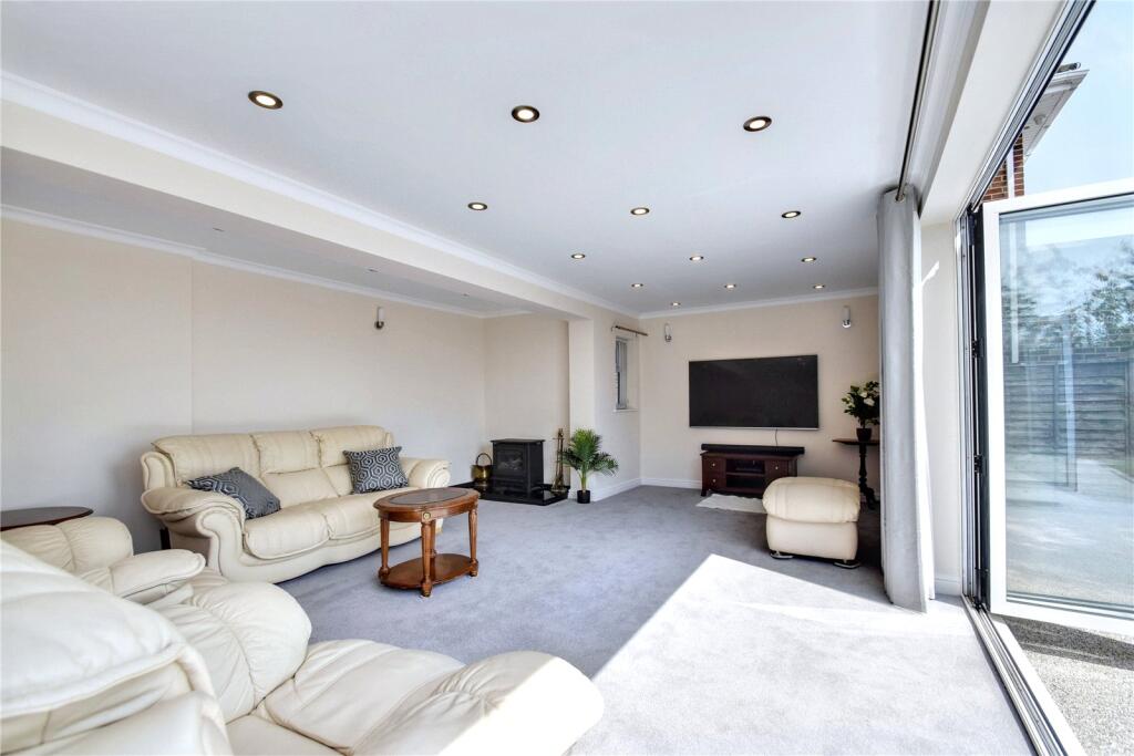
- Spacious, single-level living room with a contemporary finish. The principal reception room is large and well-lit, featuring recessed ceiling spotlights and wide full‑height sliding/bi‑fold glazing that fully opens onto a paved terrace and an expansive, mature garden with lawn, specimen trees and distant countryside views. Neutral decor and carpeted floors throughout the photographed space. The arrangement suggests a sizeable detached property with generous garden grounds and strong indoor–outdoor flow — suitable for family occupation; garden size appears large, reception room size large. No furniture or movable items have been considered in this description.
Image Descriptions
- 1970s Detached
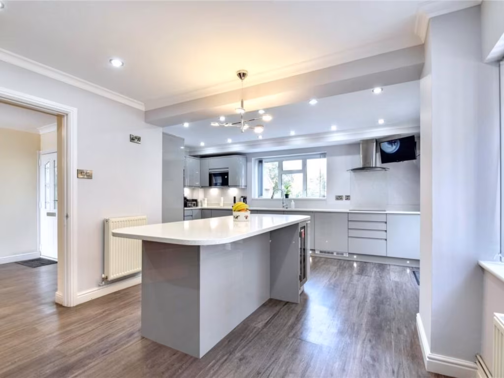
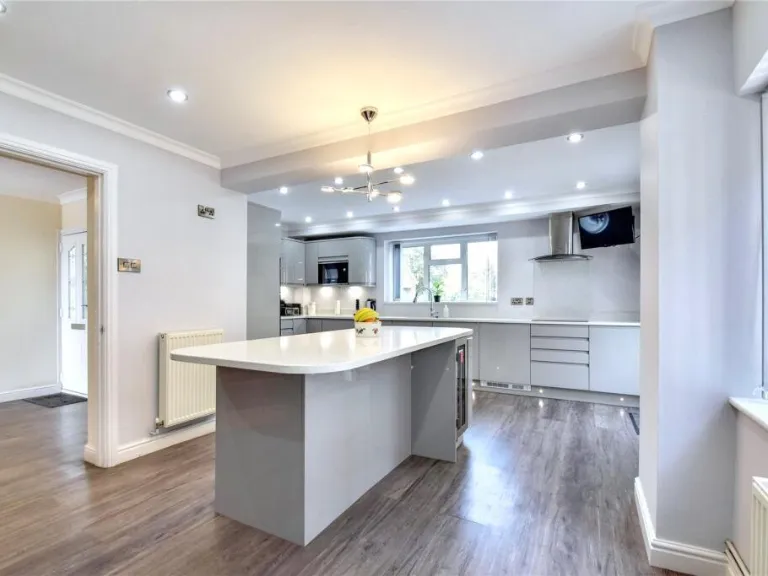
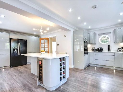
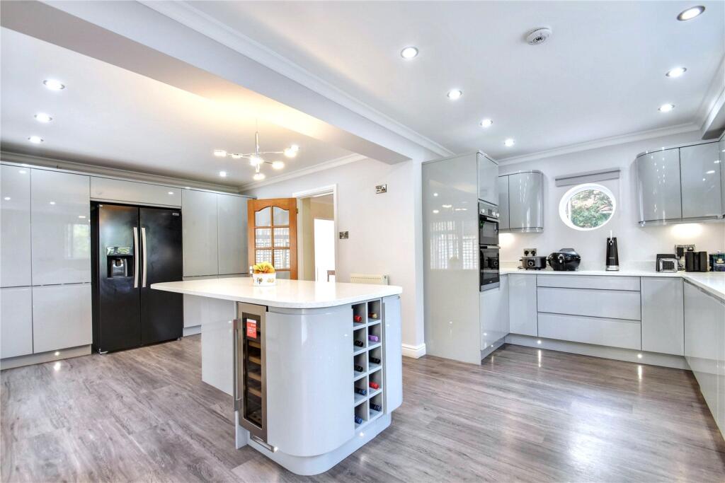
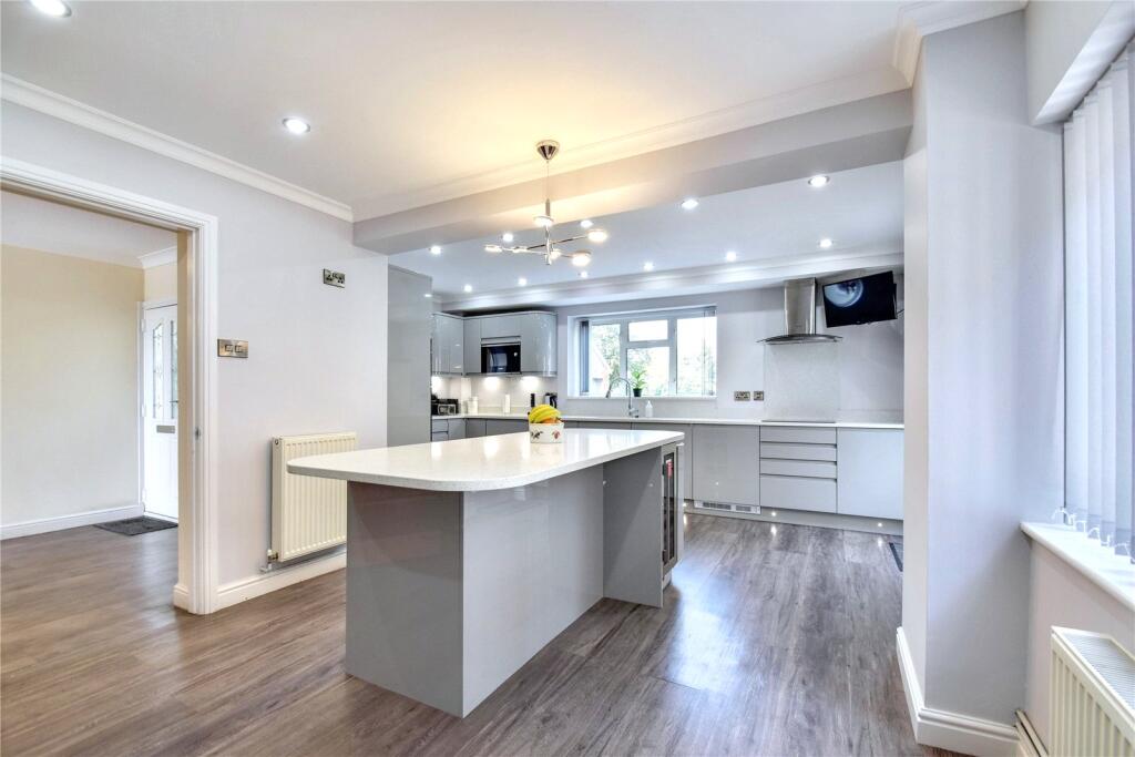
- modern kitchen contemporary
Floorplan Description
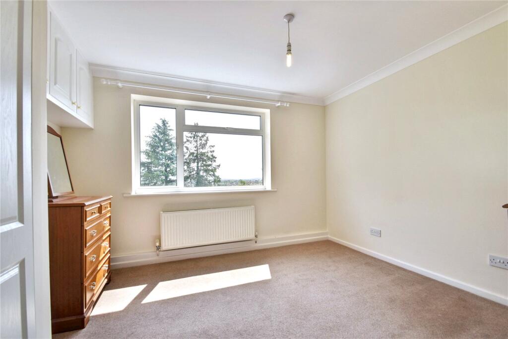
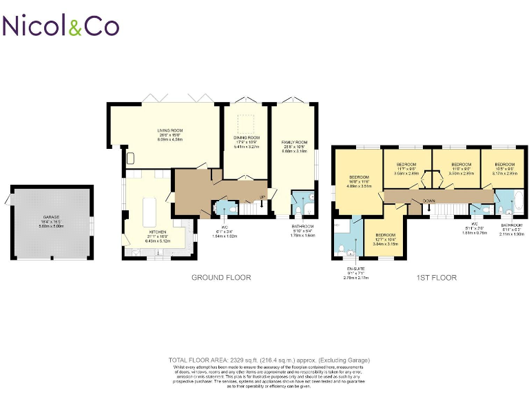
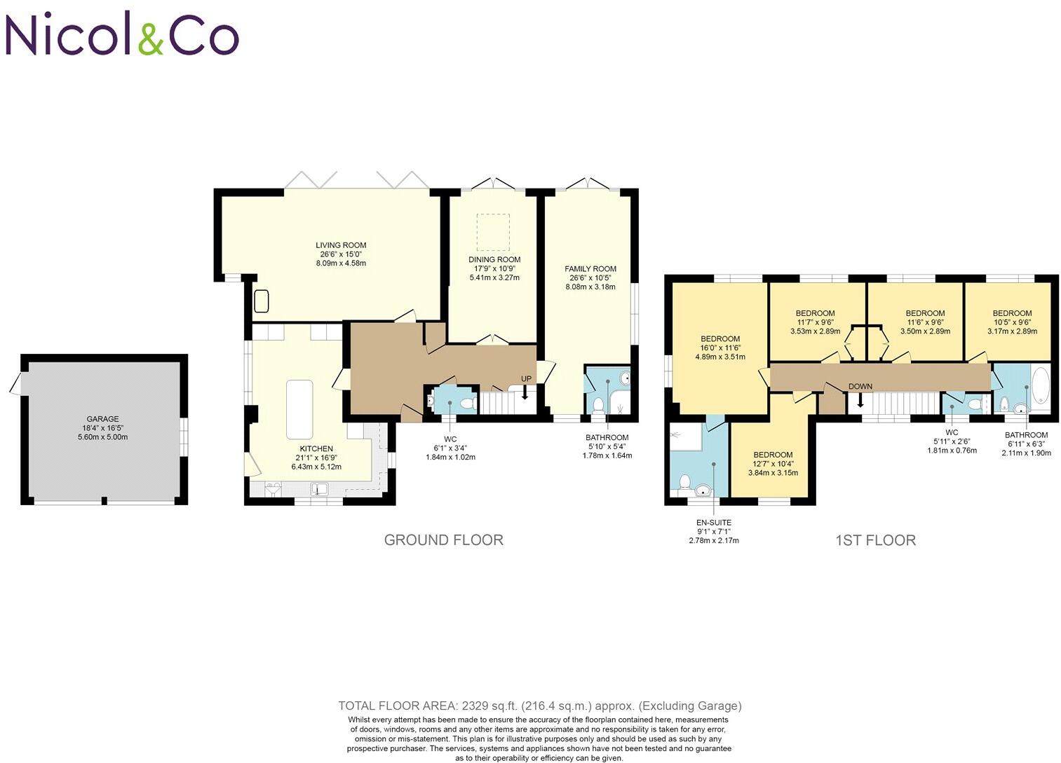
- Two-storey house floorplan (total floor area 2329 sq.ft excluding garage) with five bedrooms
Rooms
- LIVING ROOM:
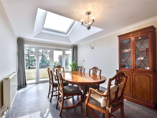
- DINING ROOM:
- FAMILY ROOM:
- KITCHEN:
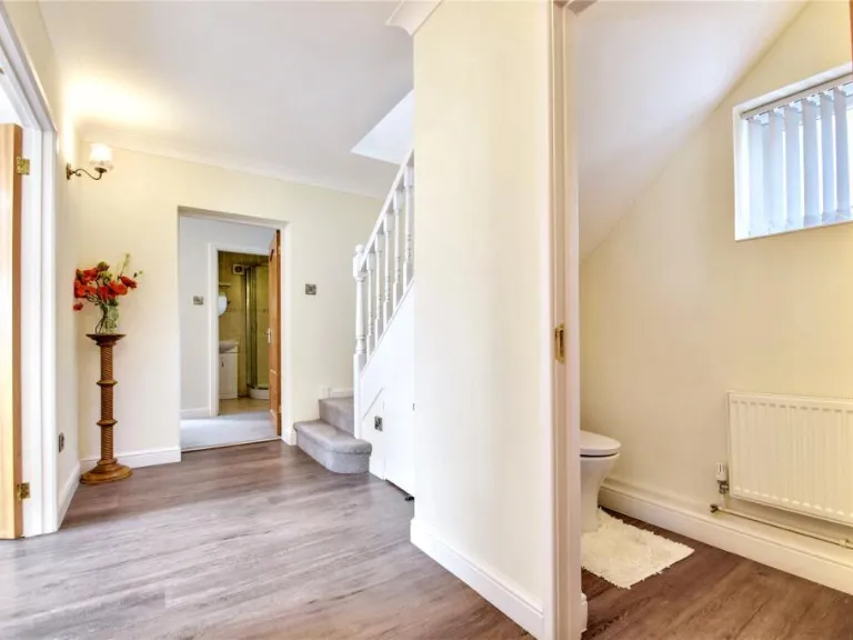
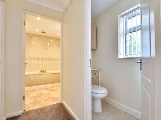
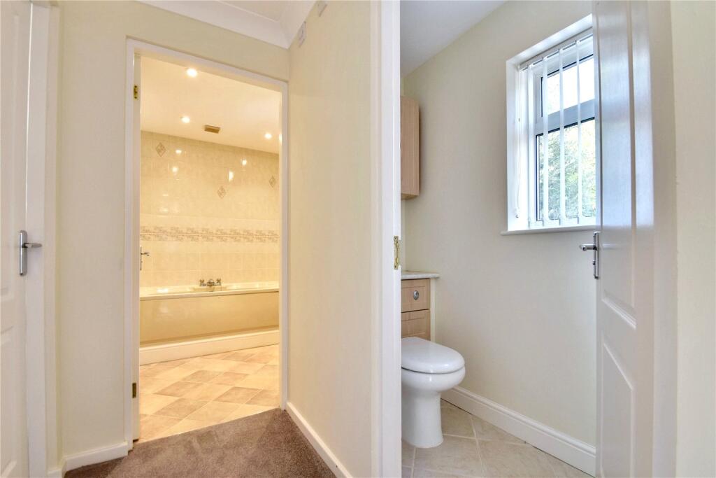
- WC:
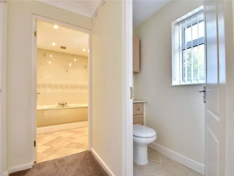
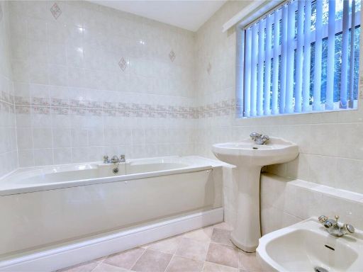
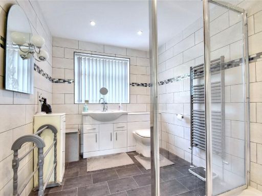
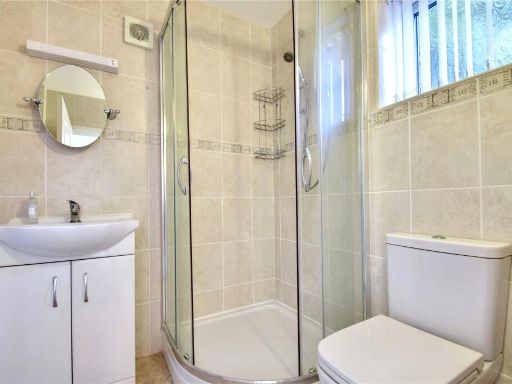
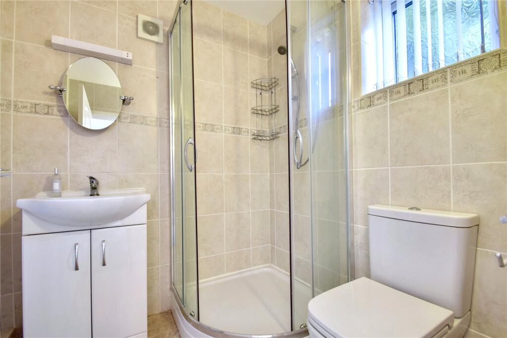
- BATHROOM:
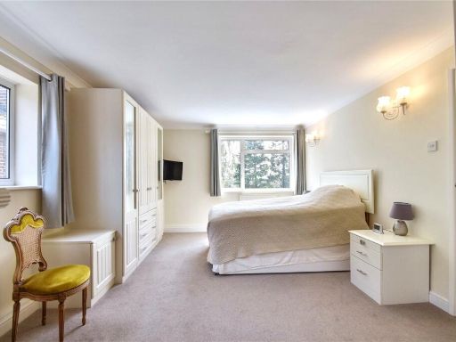
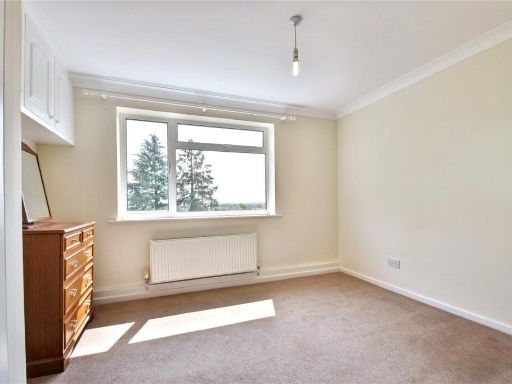
- BEDROOM:
- BEDROOM:
- BEDROOM:
- BEDROOM:
- BEDROOM:
- EN-SUITE:
- WC:
- BATHROOM:
- GARAGE:
Textual Property Features
Detected Visual Features
- detached
- 1970s
- two-story
- double garage
- driveway
- brick
- asphalt
- modern kitchen
- contemporary style
- island unit
- wine cooler
- integrated appliances
- laminate flooring
- bright lighting
- spacious
EPC Details
- Fully double glazed
- Cavity wall, filled cavity
- Boiler and radiators, mains gas
- Low energy lighting in 59% of fixed outlets
- Solid, no insulation (assumed)
Nearby Schools
- Christopher Whitehead Language College
- Newbridge School
- St George's CofE Primary School
- Cranham Primary School
- Nunnery Wood High School
- Nunnery Wood Primary School
- The King's School
- St Clement's CofE Primary
- The Lyppard Grange Primary School
- Royal Grammar School Worcester
- Hollymount School
- Bishop Perowne CofE College
- Carnforth School
- Oasis Academy Warndon
- Whittington CofE Primary School
- Pitmaston Primary School
- Red Hill CofE Primary School
- Stanley Road Primary School
- Perry Wood Primary and Nursery School
- Cherry Orchard Primary School
- Blessed Edward Oldcorne Catholic College
- St Barnabas CofE Primary School
- Tudor Grange Academy Worcester
Nearest General Shops
- Id: 1313377788
- Tags:
- Name: Shelton & Lines
- Shop: estate_agent
- TagsNormalized:
- Lat: 52.1782806
- Lon: -2.2143992
- FullGeoHash: gcq2vdg88b2r
- PartitionGeoHash: gcq2
- Images:
- FoodStandards: null
- Distance: 853.4
,- Id: 1313472955
- Tags:
- Name: The Barber Shop
- Shop: hairdresser
- TagsNormalized:
- Lat: 52.1848843
- Lon: -2.2050976
- FullGeoHash: gcq2vgfqcx80
- PartitionGeoHash: gcq2
- Images:
- FoodStandards: null
- Distance: 649
,- Id: 1313473019
- Tags:
- Name: Odds & Sods
- Phone: +44 1905 356455
- Shop: variety_store
- TagsNormalized:
- Lat: 52.1847286
- Lon: -2.2052978
- FullGeoHash: gcq2vgfnhf6z
- PartitionGeoHash: gcq2
- Images:
- FoodStandards: null
- Distance: 637.3
}
Nearest Religious buildings
- Id: 237602588
- Tags:
- Amenity: place_of_worship
- Building: church
- Denomination: anglican
- Name: Saint Mark's Church
- Religion: christian
- Wikidata: Q105105215
- TagsNormalized:
- place of worship
- church
- anglican
- christian
- Lat: 52.1768775
- Lon: -2.2147957
- FullGeoHash: gcq2vde0rdbt
- PartitionGeoHash: gcq2
- Images:
- FoodStandards: null
- Distance: 914.7
,- Id: 55027645
- Tags:
- Addr:
- Postcode: WR5 3TY
- Street: Eden Close
- Amenity: place_of_worship
- Building: church
- Denomination: baptist
- Name: Saint Peter's Baptist Church
- Religion: christian
- TagsNormalized:
- place of worship
- church
- baptist
- christian
- Lat: 52.1723309
- Lon: -2.2045771
- FullGeoHash: gcq2vcdtvekh
- PartitionGeoHash: gcq2
- Images:
- FoodStandards: null
- Distance: 801.4
,- Id: 728806360
- Tags:
- Amenity: place_of_worship
- Building: church
- Denomination: anglican
- Name: St. Martin & St. Peter
- Religion: christian
- Source: bing
- Wikidata: Q105105223
- TagsNormalized:
- place of worship
- church
- anglican
- christian
- Lat: 52.1854048
- Lon: -2.2063131
- FullGeoHash: gcq2vu16j0t9
- PartitionGeoHash: gcq2
- Images:
- FoodStandards: null
- Distance: 733
}
Nearest Medical buildings
- Id: 692134985
- Tags:
- Amenity: pharmacy
- Brand: Lloyds Pharmacy
- Brand:wikidata: Q6662870
- Brand:wikipedia: en:LloydsPharmacy
- Dispensing: yes
- Healthcare: pharmacy
- Name: Lloyds Pharmacy
- TagsNormalized:
- pharmacy
- lloyds pharmacy
- health
- healthcare
- Lat: 52.1715973
- Lon: -2.2046347
- FullGeoHash: gcq2vcd9s69h
- PartitionGeoHash: gcq2
- Images:
- FoodStandards: null
- Distance: 882
,- Id: 1313377719
- Tags:
- Addr:
- City: Worcester
- Country: GB
- Housenumber: 177
- Street: Bath Road
- Amenity: pharmacy
- Dispensing: yes
- Healthcare: pharmacy
- Name: J & J Pharmacy Ltd
- Phone: +44 1905 354651
- TagsNormalized:
- Lat: 52.1783978
- Lon: -2.2144643
- FullGeoHash: gcq2vdg3pnrd
- PartitionGeoHash: gcq2
- Images:
- FoodStandards: null
- Distance: 856.1
,- Id: 692135166
- Tags:
- Amenity: dentist
- Healthcare: dentist
- Name: Abbotsbury Court Dental Practice
- TagsNormalized:
- dentist
- health
- healthcare
- dental
- Lat: 52.1719929
- Lon: -2.2050737
- FullGeoHash: gcq2vcd7fh3u
- PartitionGeoHash: gcq2
- Images:
- FoodStandards: null
- Distance: 845.8
,- Id: 1638317264
- Tags:
- Amenity: doctors
- Healthcare: physiotherapist
- Name: Worcester Physiotherapy
- Source: sign on London Road
- TagsNormalized:
- doctor
- doctors
- physiotherapist
- health
- healthcare
- physiotherapy
- therapy
- Lat: 52.1831519
- Lon: -2.2014495
- FullGeoHash: gcq2vgsuys86
- PartitionGeoHash: gcq2
- Images:
- FoodStandards: null
- Distance: 422.9
}
Nearest Leisure Facilities
- Id: 54836487
- Tags:
- TagsNormalized:
- Lat: 52.1746233
- Lon: -2.2076114
- FullGeoHash: gcq2vf07nytx
- PartitionGeoHash: gcq2
- Images:
- FoodStandards: null
- Distance: 651
,- Id: 730416185
- Tags:
- Leisure: pitch
- Sport: multi
- Surface: artificial_turf
- TagsNormalized:
- Lat: 52.1800642
- Lon: -2.2107136
- FullGeoHash: gcq2ven4ysur
- PartitionGeoHash: gcq2
- Images:
- FoodStandards: null
- Distance: 598.6
,- Id: 55038212
- Tags:
- TagsNormalized:
- Lat: 52.1752859
- Lon: -2.2019626
- FullGeoHash: gcq2vfhx4d1x
- PartitionGeoHash: gcq2
- Images:
- FoodStandards: null
- Distance: 453.4
,- Id: 871363228
- Tags:
- Leisure: pitch
- Sport: multi
- TagsNormalized:
- Lat: 52.1817258
- Lon: -2.2043814
- FullGeoHash: gcq2vg6ud4wp
- PartitionGeoHash: gcq2
- Images:
- FoodStandards: null
- Distance: 308.5
,- Id: 1577472476
- Tags:
- TagsNormalized:
- Lat: 52.1796236
- Lon: -2.1982604
- FullGeoHash: gcq2vgp22ff4
- PartitionGeoHash: gcq2
- Images:
- FoodStandards: null
- Distance: 257.2
}
Nearest Tourist attractions
- Id: 266147107
- Tags:
- Building: yes
- Fee: yes
- Name: Museum of Royal Worcester
- Source: bing
- Tourism: museum
- Wikidata: Q540718
- Wikipedia: en:Museum of Royal Worcester
- TagsNormalized:
- Lat: 52.1872
- Lon: -2.2190042
- FullGeoHash: gcq2vs2hmrnt
- PartitionGeoHash: gcq2
- Images:
- FoodStandards: null
- Distance: 1449.8
,- Id: 266149681
- Tags:
- Addr:
- City: Worcester
- Postcode: WR1 2HU
- Street: Sidbury
- Building: yes
- Fhrs:
- Heritage: 2
- Heritage:operator: eh
- Listed_status: Grade I
- Name: The Commandery
- Source: bing
- Tourism: museum
- Wikidata: Q7726974
- Wikipedia: en:The Commandery
- TagsNormalized:
- Lat: 52.1878621
- Lon: -2.2167895
- FullGeoHash: gcq2vs9b349g
- PartitionGeoHash: gcq2
- Images:
- FoodStandards:
- Id: 685561
- FHRSID: 685561
- LocalAuthorityBusinessID: WO/03132/CP
- BusinessName: The Commandery
- BusinessType: Retailers - other
- BusinessTypeID: 4613
- AddressLine1: Sidbury
- AddressLine2: Worcester
- AddressLine3: null
- AddressLine4: null
- PostCode: WR1 2HU
- RatingValue: Exempt
- RatingKey: fhrs_exempt_en-GB
- RatingDate: 2011-03-25
- LocalAuthorityCode: 151
- LocalAuthorityName: Worcester City
- LocalAuthorityWebSite: https://www.worcsregservices.gov.uk
- LocalAuthorityEmailAddress: enquiries@worcsregservices.gov.uk
- Scores:
- Hygiene: null
- Structural: null
- ConfidenceInManagement: null
- NewRatingPending: false
- Geocode:
- Longitude: null
- Latitude: null
- Distance: 1381.5
,- Id: 1577472479
- Tags:
- TagsNormalized:
- Lat: 52.1803275
- Lon: -2.1987644
- FullGeoHash: gcq2vgnumn43
- PartitionGeoHash: gcq2
- Images:
- FoodStandards: null
- Distance: 245.8
}
Nearest Train stations
- Id: 21227482
- Tags:
- Name: Droitwich Spa
- Naptan:
- Network: National Rail
- Operator: London Midland
- Platforms: 2
- Public_transport: station
- Railway: station
- Ref:
- Train: yes
- Wikidata: Q2360854
- Wikipedia: en:Droitwich Spa railway station
- TagsNormalized:
- Lat: 52.2683805
- Lon: -2.1583391
- FullGeoHash: gcq3qghm7h3d
- PartitionGeoHash: gcq3
- Images:
- FoodStandards: null
- Distance: 10335.5
,- Id: 21279791
- Tags:
- Addr:
- Name: Malvern Link
- Naptan:
- Network: National Rail
- Public_transport: station
- Railway: station
- Ref:
- Source: NPE
- Wikidata: Q2657768
- Wikipedia: en:Malvern Link railway station
- TagsNormalized:
- Lat: 52.1258094
- Lon: -2.3195676
- FullGeoHash: gcq2e1nyy5jh
- PartitionGeoHash: gcq2
- Images:
- FoodStandards: null
- Distance: 9989.5
,- Id: 7216839133
- Tags:
- Name: Worcestershire Parkway
- Naptan:
- Network: National Rail
- Operator: Great Western Railway
- Public_transport: station
- Railway: station
- Ref:
- Train: yes
- Wheelchair: yes
- Wikipedia: en:Worcestershire Parkway railway station
- TagsNormalized:
- Lat: 52.1561771
- Lon: -2.1600339
- FullGeoHash: gcq2wyepg81g
- PartitionGeoHash: gcq2
- Images:
- FoodStandards: null
- Distance: 3852.6
,- Id: 7209335261
- Tags:
- Name: Worcester Foregate Street
- Naptan:
- Network: National Rail
- Public_transport: station
- Railway: station
- Ref:
- Wikidata: Q1873465
- Wikipedia: en:Worcester Foregate Street railway station
- TagsNormalized:
- Lat: 52.1953289
- Lon: -2.2207959
- FullGeoHash: gcq2vmyggdw8
- PartitionGeoHash: gcq2
- Images:
- FoodStandards: null
- Distance: 2189
,- Id: 6609023830
- Tags:
- Name: Worcester Shrub Hill
- Naptan:
- Network: National Rail
- Public_transport: station
- Railway: station
- Ref:
- Wikidata: Q1974749
- Wikipedia: en:Worcester Shrub Hill railway station
- TagsNormalized:
- Lat: 52.1950309
- Lon: -2.2093282
- FullGeoHash: gcq2vtz4nfvr
- PartitionGeoHash: gcq2
- Images:
- FoodStandards: null
- Distance: 1812.2
}
Nearest Hotels
- Id: 224994101
- Tags:
- Brand: Travelodge
- Brand:wikidata: Q9361374
- Brand:wikipedia: en:Travelodge UK
- Building: yes
- Internet_access: wlan
- Internet_access:fee: customers
- Internet_access:ssid: Travelodge WiFi
- Layer: 2
- Name: Travelodge
- Tourism: hotel
- TagsNormalized:
- Lat: 52.1901198
- Lon: -2.2195159
- FullGeoHash: gcq2vkzv3x2z
- PartitionGeoHash: gcq2
- Images:
- FoodStandards: null
- Distance: 1689.7
,- Id: 127177046
- Tags:
- Addr:
- City: Worcester
- Postcode: WR1 2NF
- Street: Severn Street
- Amenity: restaurant
- Building: yes
- Fhrs:
- Name: Diglis House Hotel
- Tourism: hotel
- Wikidata: Q26669565
- TagsNormalized:
- Lat: 52.1863232
- Lon: -2.2221908
- FullGeoHash: gcq2vkjz75wr
- PartitionGeoHash: gcq2
- Images:
- FoodStandards: null
- Distance: 1578.7
,- Id: 460814634
- Tags:
- Addr:
- City: Worcester
- Housenumber: 5
- Postcode: WR1 2AP
- Street: Clare Street
- Building: yes
- Fhrs:
- Name: Fownes Hotel
- Tourism: hotel
- Wikidata: Q24039211
- TagsNormalized:
- Lat: 52.189424
- Lon: -2.2170354
- FullGeoHash: gcq2vsc97mf8
- PartitionGeoHash: gcq2
- Images:
- FoodStandards: null
- Distance: 1516.9
}
Tags
- detached
- 1970s
- two-story
- double garage
- driveway
- brick
- asphalt
- modern kitchen
- contemporary style
- island unit
- wine cooler
- integrated appliances
- laminate flooring
- bright lighting
- spacious
Local Market Stats
- Average Price/sqft: £290
- Avg Income: £48300
- Rental Yield: 4.2%
- Social Housing: 10%
- Planning Success Rate: 86%
AirBnB Data
- 1km average: £95/night
- Listings in 1km: 1
Similar Properties
 4 bedroom detached house for sale in The Ridgeway, Worcester, WR5 — £600,000 • 4 bed • 3 bath • 1874 ft²
 3 bedroom detached house for sale in 48 Wyche Road, Malvern, Worcestershire, WR14 — £485,000 • 3 bed • 1 bath • 1036 ft²
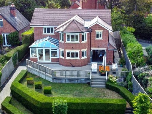 4 bedroom detached house for sale in St. Peters Road, Malvern, WR14 — £1,250,000 • 4 bed • 3 bath • 2831 ft²
 3 bedroom detached house for sale in Bomford Hill, Worcester, Worcestershire, WR4 — £365,000 • 3 bed • 2 bath • 1331 ft²
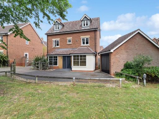 4 bedroom detached house for sale in Sayers Avenue, Malvern, Worcestershire, WR14 1PR, WR14 — £425,000 • 4 bed • 2 bath • 1594 ft²
 4 bedroom detached house for sale in Grasshopper Avenue, Worcester, Worcestershire, WR5 — £450,000 • 4 bed • 3 bath • 1324 ft²
Meta
- {
"@context": "https://schema.org",
"@type": "Residence",
"name": "5 bedroom detached house for sale in Battenhall Avenue, Wor…",
"description": "",
"url": "https://propertypiper.co.uk/property/950d2e31-172c-4e1a-8bce-ca97eff239d9",
"image": "https://image-a.propertypiper.co.uk/0dbab655-4c15-4430-b22c-31a97430a673-1024.jpeg",
"address": {
"@type": "PostalAddress",
"streetAddress": "PYRMONT BATTENHALL AVENUE WORCESTER",
"postalCode": "WR5 2HW",
"addressLocality": "Worcester",
"addressRegion": "Worcester",
"addressCountry": "England"
},
"geo": {
"@type": "GeoCoordinates",
"latitude": 52.17936374971071,
"longitude": -2.2020085638216402
},
"numberOfRooms": 5,
"numberOfBathroomsTotal": 3,
"floorSize": {
"@type": "QuantitativeValue",
"value": 2329,
"unitCode": "FTK"
},
"offers": {
"@type": "Offer",
"price": 825000,
"priceCurrency": "GBP",
"availability": "https://schema.org/InStock"
},
"additionalProperty": [
{
"@type": "PropertyValue",
"name": "Feature",
"value": "detached"
},
{
"@type": "PropertyValue",
"name": "Feature",
"value": "1970s"
},
{
"@type": "PropertyValue",
"name": "Feature",
"value": "two-story"
},
{
"@type": "PropertyValue",
"name": "Feature",
"value": "double garage"
},
{
"@type": "PropertyValue",
"name": "Feature",
"value": "driveway"
},
{
"@type": "PropertyValue",
"name": "Feature",
"value": "brick"
},
{
"@type": "PropertyValue",
"name": "Feature",
"value": "asphalt"
},
{
"@type": "PropertyValue",
"name": "Feature",
"value": "modern kitchen"
},
{
"@type": "PropertyValue",
"name": "Feature",
"value": "contemporary style"
},
{
"@type": "PropertyValue",
"name": "Feature",
"value": "island unit"
},
{
"@type": "PropertyValue",
"name": "Feature",
"value": "wine cooler"
},
{
"@type": "PropertyValue",
"name": "Feature",
"value": "integrated appliances"
},
{
"@type": "PropertyValue",
"name": "Feature",
"value": "laminate flooring"
},
{
"@type": "PropertyValue",
"name": "Feature",
"value": "bright lighting"
},
{
"@type": "PropertyValue",
"name": "Feature",
"value": "spacious"
}
]
}
High Res Floorplan Images
Compatible Floorplan Images
FloorplanImages Thumbnail