NE64 6HN - Residential development for sale in Woodhorn Road, Newbiggi…
View on Property Piper
Residential development for sale in Woodhorn Road, Newbiggin-By-The-Sea, Northumberland, NE64
Property Details
- Price: £1000000
- Bedrooms: 1
- Bathrooms: 1
- Property Type: undefined
- Property SubType: undefined
Brochure Descriptions
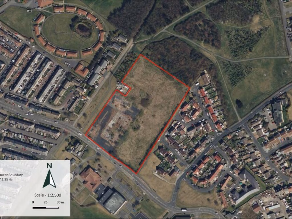
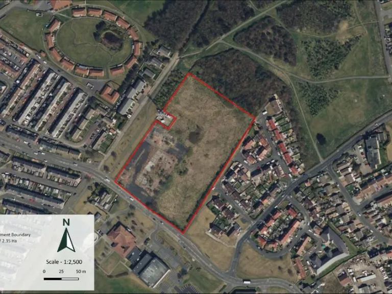
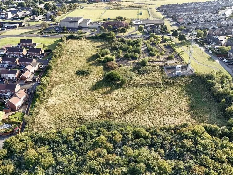
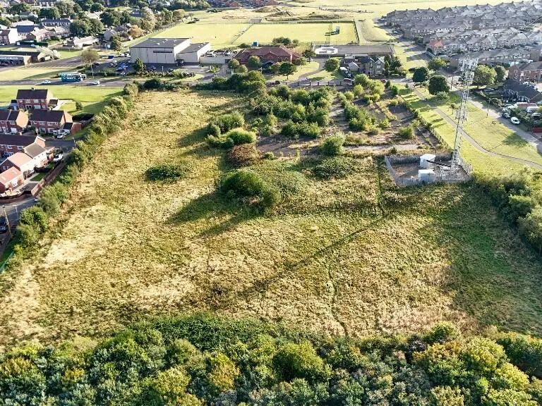
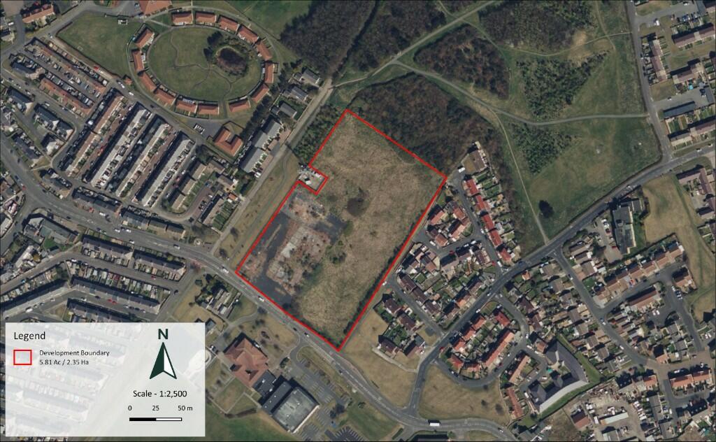
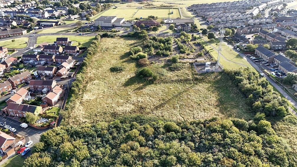
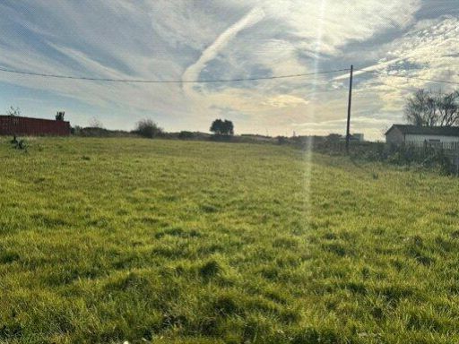
- The property is a large plot ideal for residential development, situated on the site of a former school. The surrounding area is suburban, with neighboring residential estates visible in the vicinity. The land is predominantly flat with some patches of vegetation, offering potential for multiple residential units. The site provides an expansive area suitable for building, aligning with existing infrastructure and enjoying an open layout.
Textual Property Features
Detected Visual Features
- development opportunity
- vacant land
- plot
- investment
- residential area
- potential
- redevelopment
- urban fringe
- land plot
Nearby Schools
- Bedlington Academy
- NCEA James Knott CofE Primary School
- Ashington Academy
- NCEA Grace Darling CofE Primary School
- Linton Primary School
- Newsham Primary School
- Horton Grange Primary School
- Stead Lane Primary School
- Central Primary School
- NCEA William Leech CofE Primary School
- Bede Academy
- The Blyth Academy
- Malvin's Close Academy
- Morpeth Road Academy
- Bedlington Station Primary School
- NCEA Bishop's Primary School
- NCEA Duke's Secondary School
- Croftway Academy
- St Wilfrid's Catholic Primary School
- Cambois Primary School
- Stakeford Primary School
- St Aidan's Catholic Primary School, Ashington
- NCEA Thomas Bewick C of E Primary School
- Bothal Primary School
- Ellington Primary School
Nearest General Shops
- Id: 1029972861
- Tags:
- Addr:
- City: Newbiggin by the Sea
- Country: GB
- County: Northumberland
- Housenumber: 47
- Postcode: NE64 6NJ
- Street: Front Street
- Building: retail
- Fhrs:
- Name: New Butcher by the Sea
- Shop: butcher
- Source: survey
- TagsNormalized:
- Lat: 55.1849476
- Lon: -1.5119841
- FullGeoHash: gcycvw5585yf
- PartitionGeoHash: gcyc
- Images:
- FoodStandards:
- Id: 578329
- FHRSID: 578329
- LocalAuthorityBusinessID: 39133
- BusinessName: New Butcher by the Sea
- BusinessType: Retailers - other
- BusinessTypeID: 4613
- AddressLine1: 47 Front Street
- AddressLine2: Newbiggin-By-The-Sea
- AddressLine3: Northumberland
- AddressLine4: null
- PostCode: NE64 6NJ
- RatingValue: 5
- RatingKey: fhrs_5_en-GB
- RatingDate: 2020-02-27
- LocalAuthorityCode: 707
- LocalAuthorityName: Northumberland
- LocalAuthorityWebSite: http://www.northumberland.gov.uk
- LocalAuthorityEmailAddress: public.protection@northumberland.gov.uk
- Scores:
- Hygiene: 0
- Structural: 5
- ConfidenceInManagement: 0
- NewRatingPending: false
- Geocode:
- Longitude: -1.51151200000000
- Latitude: 55.18501900000000
- Distance: 182.2
,- Id: 88034942
- Tags:
- Addr:
- City: Newbiggin by the Sea
- Country: GB
- County: Northumberland
- Housenumber: 45
- Postcode: NE64 6NJ
- Street: Front Street
- Building: retail
- Name: POP UP
- Shop: yes
- Source: survey
- TagsNormalized:
- Lat: 55.1849289
- Lon: -1.5120653
- FullGeoHash: gcycvw4gw267
- PartitionGeoHash: gcyc
- Images:
- FoodStandards: null
- Distance: 178.5
,- Id: 3837781201
- Tags:
- Addr:
- City: Newbiggin by the Sea
- Country: GB
- County: Northumberland
- Street: Front Street
- Name: The Grooming Room
- Shop: pet
- TagsNormalized:
- Lat: 55.1852541
- Lon: -1.5120057
- FullGeoHash: gcycvw4vrsyz
- PartitionGeoHash: gcyc
- Images:
- FoodStandards: null
- Distance: 169.6
}
Nearest Airports
- Id: 51496177
- Tags:
- Addr:
- City: Newcastle upon Tyne
- Housename: Newcastle International Airport
- Postcode: NE13 8BZ
- Street: Woolsington
- Aerodrome: international
- Aerodrome:type: public
- Aeroway: aerodrome
- Contact:
- Website: http://www.newcastleairport.com
- Ele: 81
- Iata: NCL
- Icao: EGNT
- Ifr: yes
- Name: Newcastle International Airport
- Old_name: Woolsington Aerodrome
- Operator: Newcastle International Airport Ltd
- Operator:type: private
- Phone: +44 871 882 1121
- Ref: NCL
- Size: 4500000
- Source: Bing
- Vfr: yes
- Website: https://www.newcastleairport.com/
- Wheelchair: yes
- Wikidata: Q8975
- Wikipedia: en:Newcastle International Airport
- TagsNormalized:
- airport
- international airport
- Lat: 55.0385826
- Lon: -1.6925163
- FullGeoHash: gcyc17rwcx2m
- PartitionGeoHash: gcyc
- Images:
- FoodStandards: null
- Distance: 19884.7
,- Id: 224091164
- Tags:
- Addr:
- City: Newcastle upon Tyne
- Postcode: NE13 8BZ
- Street: Woolsington
- Building: hotel
- Contact:
- Facebook: https://www.facebook.com/doubletree.newcastle
- Google_plus: https://plus.google.com/115643701064921491168/about
- Twitter: https://twitter.com/dtnewcastle_int
- Email: info@doubletree-newcastle.co.uk
- Fhrs:
- Name: DoubleTree by Hilton Hotel Newcastle International Airport
- Operator: Hilton Worldwide
- Phone: +44 1661 824266
- Rooms: 179
- Smoking: no
- Stars: 4
- Tourism: hotel
- Website: https://doubletree3.hilton.com/en/hotels/united-kingdom/doubletree-by-hilton-hotel-newcastle-international-airport-NCLNADI/index.html?WT.mc_id=zELWAKN0EMEA1DT2DMH3LocalSearch4DGGenericx6NCLNADI
- Wheelchair: yes
- TagsNormalized:
- hotel
- airport
- international airport
- tourism
- major airport
- Lat: 55.0364476
- Lon: -1.7124358
- FullGeoHash: gcyc1514937m
- PartitionGeoHash: gcyc
- Images:
- FoodStandards:
- Id: 236731
- FHRSID: 236731
- LocalAuthorityBusinessID: 11/00246/MIXED
- BusinessName: Doubletree By Hilton Hotel
- BusinessType: Hotel/bed & breakfast/guest house
- BusinessTypeID: 7842
- AddressLine1: Doubletree By Hilton Newcastle Airport
- AddressLine2: Woolsington
- AddressLine3: Newcastle Upon Tyne
- AddressLine4: null
- PostCode: NE13 8BZ
- RatingValue: 5
- RatingKey: fhrs_5_en-GB
- RatingDate: 2019-08-13
- LocalAuthorityCode: 416
- LocalAuthorityName: Newcastle Upon Tyne
- LocalAuthorityWebSite: http://www.newcastle.gov.uk/
- LocalAuthorityEmailAddress: psr@newcastle.gov.uk
- Scores:
- Hygiene: 0
- Structural: 5
- ConfidenceInManagement: 0
- NewRatingPending: false
- Geocode:
- Longitude: -1.71254240000000
- Latitude: 55.03664040000000
- Distance: 20820.8
}
Nearest Train stations
- Id: 5520053927
- Tags:
- Name: Acklington
- Naptan:
- Network: National Rail
- Operator: Northern
- Public_transport: station
- Railway: station
- Ref:
- Source: NPE
- Wikidata: Q3517520
- Wikipedia: en:Acklington railway station
- TagsNormalized:
- Lat: 55.3072171
- Lon: -1.6517687
- FullGeoHash: gcyfdkm5yuxb
- PartitionGeoHash: gcyf
- Images:
- FoodStandards: null
- Distance: 16074.5
,- Id: 8068832751
- Tags:
- Name: Cramlington
- Naptan:
- Network: National Rail
- Operator: Northern
- Public_transport: station
- Railway: station
- Ref:
- Wikidata: Q2007937
- Wikipedia: en:Cramlington railway station
- TagsNormalized:
- Lat: 55.0877627
- Lon: -1.5986832
- FullGeoHash: gcyc7s7v7zr2
- PartitionGeoHash: gcyc
- Images:
- FoodStandards: null
- Distance: 12124
,- Id: 7209360087
- Tags:
- Name: Morpeth
- Naptan:
- Network: National Rail
- Public_transport: station
- Railway: station
- Ref:
- Wikidata: Q2534198
- Wikipedia: en:Morpeth railway station
- TagsNormalized:
- Lat: 55.1623623
- Lon: -1.6831484
- FullGeoHash: gcyccdn25c9s
- PartitionGeoHash: gcyc
- Images:
- FoodStandards: null
- Distance: 11011.7
,- Id: 46985645
- Tags:
- Name: Widdrington
- Naptan:
- Network: National Rail
- Public_transport: station
- Railway: station
- Ref:
- Source: NPE
- Wheelchair: yes
- Wikidata: Q2572775
- Wikipedia: en:Widdrington railway station
- TagsNormalized:
- Lat: 55.2411444
- Lon: -1.6162192
- FullGeoHash: gcyf70r4gret
- PartitionGeoHash: gcyf
- Images:
- FoodStandards: null
- Distance: 8925.7
,- Id: 6738885509
- Tags:
- Name: Pegswood
- Naptan:
- Network: National Rail
- Public_transport: station
- Railway: station
- Ref:
- Source: NPE
- Train: yes
- Wikidata: Q2495528
- Wikipedia: en:Pegswood railway station
- TagsNormalized:
- Lat: 55.1783232
- Lon: -1.6437205
- FullGeoHash: gcycfsgj48cn
- PartitionGeoHash: gcyc
- Images:
- FoodStandards: null
- Distance: 8238.3
}
Nearest Bus stations and stops
- Id: 9610486659
- Tags:
- Bus: yes
- Highway: bus_stop
- Public_transport: platform
- TagsNormalized:
- Lat: 55.1747045
- Lon: -1.5405486
- FullGeoHash: gcycuunpyw7s
- PartitionGeoHash: gcyc
- Images:
- FoodStandards: null
- Distance: 2047.3
,- Id: 2487314035
- Tags:
- Bus: yes
- Highway: bus_stop
- Public_transport: platform
- TagsNormalized:
- Lat: 55.1729062
- Lon: -1.5359409
- FullGeoHash: gcycv5ct3zpm
- PartitionGeoHash: gcyc
- Images:
- FoodStandards: null
- Distance: 1959.2
,- Id: 2487314060
- Tags:
- Bus: yes
- Highway: bus_stop
- Public_transport: platform
- TagsNormalized:
- Lat: 55.1729279
- Lon: -1.5338764
- FullGeoHash: gcycv5gjd54y
- PartitionGeoHash: gcyc
- Images:
- FoodStandards: null
- Distance: 1869.1
,- Id: 7276433717
- Tags:
- Bench: no
- Bus: yes
- Highway: bus_stop
- Name: Newbiggin, Cresswell Arms
- Naptan:
- Public_transport: platform
- Ref: nldawgjg
- Shelter: yes
- Source: survey
- Tactile_paving: yes
- TagsNormalized:
- Lat: 55.1867802
- Lon: -1.5048306
- FullGeoHash: gcycvy2nqcky
- PartitionGeoHash: gcyc
- Images:
- FoodStandards: null
- Distance: 632.9
,- Id: 7860862964
- Tags:
- Bench: yes
- Bin: yes
- Highway: bus_stop
- Public_transport: stop_position
- Shelter: yes
- Tactile_paving: yes
- TagsNormalized:
- Lat: 55.1804176
- Lon: -1.5167543
- FullGeoHash: gcycvmr91p6h
- PartitionGeoHash: gcyc
- Images:
- FoodStandards: null
- Distance: 595.6
}
Nearest Hotels
- Id: 4321187487
- Tags:
- Name: Marlow Lodge
- Tourism: hotel
- TagsNormalized:
- Lat: 55.1261674
- Lon: -1.5171669
- FullGeoHash: gcyct7rjpqqm
- PartitionGeoHash: gcyc
- Images:
- FoodStandards: null
- Distance: 6613.9
,- Id: 102597782
- Tags:
- Addr:
- City: Blyth
- Street: Regent Street
- Amenity: pub
- Building: yes
- Name: The Reef Hotel
- Source: Bing
- TagsNormalized:
- Lat: 55.1305532
- Lon: -1.5122552
- FullGeoHash: gcycts4y9zuz
- PartitionGeoHash: gcyc
- Images:
- FoodStandards: null
- Distance: 6126
,- Id: 210063931
- Tags:
- Addr:
- City: Ashington
- Postcode: NE63 9AT
- Subdistrict: Queen Elizabeth Country Park
- Suburb: Woodhorn
- Brand: Premier Inn
- Brand:wikidata: Q2108626
- Brand:wikipedia: en:Premier Inn
- Building: yes
- Internet_access: wlan
- Internet_access:fee: customers
- Internet_access:operator: Virgin Media
- Internet_access:ssid: Premier Inn Free Wi-Fi
- Name: Premier Inn
- Tourism: hotel
- TagsNormalized:
- Lat: 55.1970028
- Lon: -1.5534827
- FullGeoHash: gcyfh8kcc5p7
- PartitionGeoHash: gcyf
- Images:
- FoodStandards: null
- Distance: 2773.5
}
Tags
- development opportunity
- vacant land
- plot
- investment
- residential area
- potential
- redevelopment
- vacant land
- development opportunity
- investment
- residential area
- urban fringe
- land plot
Local Market Stats
- Average Price/sqft: £119
- Avg Income: £29500
- Social Housing: 21%
- Planning Success Rate: 89%
AirBnB Data
- 1km average: £115/night
- Listings in 1km: 3
Similar Properties
 Land for sale in Land At Wembley Gardens, Cambois, Northumberland, NE24 — £650,000 • 1 bed • 1 bath
 Land for sale in Land Adjacent To Hatfield House, Borough Road, North Shields, NE29 — £300,000 • 1 bed • 1 bath • 10890 ft²
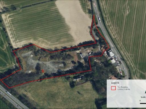 Residential development for sale in Clifton Park, Great North Road, Morpeth, Northumberland, NE61 6DG, NE61 — £3,000,000 • 1 bed • 1 bath
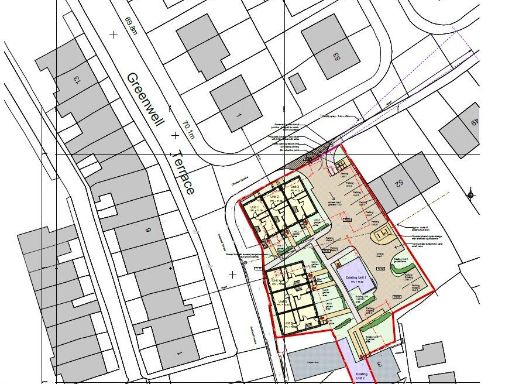 Plot for sale in Former Miners Hall, Crawcrook, Tyne and Wear, NE40 — £295,000 • 1 bed • 1 bath
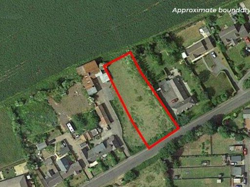 Land for sale in Land To The West Of 1 North Side, Shilbottle, Alnwick, NE66 — £260,000 • 1 bed • 1 bath • 20473 ft²
 Land for sale in Land At Sandy Lane, North Gosforth, NE13 — £625,000 • 1 bed • 1 bath
Meta
- {
"@context": "https://schema.org",
"@type": "Residence",
"name": "Residential development for sale in Woodhorn Road, Newbiggi…",
"description": "",
"url": "https://propertypiper.co.uk/property/81ba683b-5aca-4f28-8075-163d87724578",
"image": "https://image-a.propertypiper.co.uk/57590995-826f-4d94-8840-09fcebef1541-1024.jpeg",
"address": {
"@type": "PostalAddress",
"streetAddress": "WOODHORN ROAD, NEWBIGGIN-BY-THE-SEA",
"postalCode": "NE64 6HN",
"addressLocality": "Northumberland",
"addressRegion": "Wansbeck",
"addressCountry": "England"
},
"geo": {
"@type": "GeoCoordinates",
"latitude": 55.1856297,
"longitude": -1.5145944
},
"numberOfRooms": 1,
"numberOfBathroomsTotal": 1,
"offers": {
"@type": "Offer",
"price": 1000000,
"priceCurrency": "GBP",
"availability": "https://schema.org/InStock"
},
"additionalProperty": [
{
"@type": "PropertyValue",
"name": "Feature",
"value": "development opportunity"
},
{
"@type": "PropertyValue",
"name": "Feature",
"value": "vacant land"
},
{
"@type": "PropertyValue",
"name": "Feature",
"value": "plot"
},
{
"@type": "PropertyValue",
"name": "Feature",
"value": "investment"
},
{
"@type": "PropertyValue",
"name": "Feature",
"value": "residential area"
},
{
"@type": "PropertyValue",
"name": "Feature",
"value": "potential"
},
{
"@type": "PropertyValue",
"name": "Feature",
"value": "redevelopment"
},
{
"@type": "PropertyValue",
"name": "Feature",
"value": "vacant land"
},
{
"@type": "PropertyValue",
"name": "Feature",
"value": "development opportunity"
},
{
"@type": "PropertyValue",
"name": "Feature",
"value": "investment"
},
{
"@type": "PropertyValue",
"name": "Feature",
"value": "residential area"
},
{
"@type": "PropertyValue",
"name": "Feature",
"value": "urban fringe"
},
{
"@type": "PropertyValue",
"name": "Feature",
"value": "land plot"
}
]
}