HX3 7HH - Land for sale in Land At Back Clough, Bradford Road, Northo…
View on Property Piper
Land for sale in Land At Back Clough, Bradford Road, Northowram, Halifax, HX3 7HH, HX3
Property Details
- Price: £1350000
- Bedrooms: 1
- Bathrooms: 1
- Property Type: undefined
- Property SubType: undefined
Brochure Descriptions
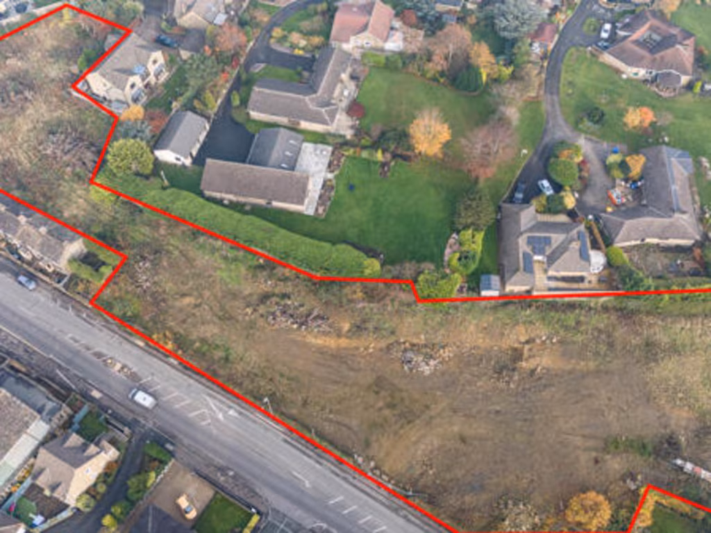
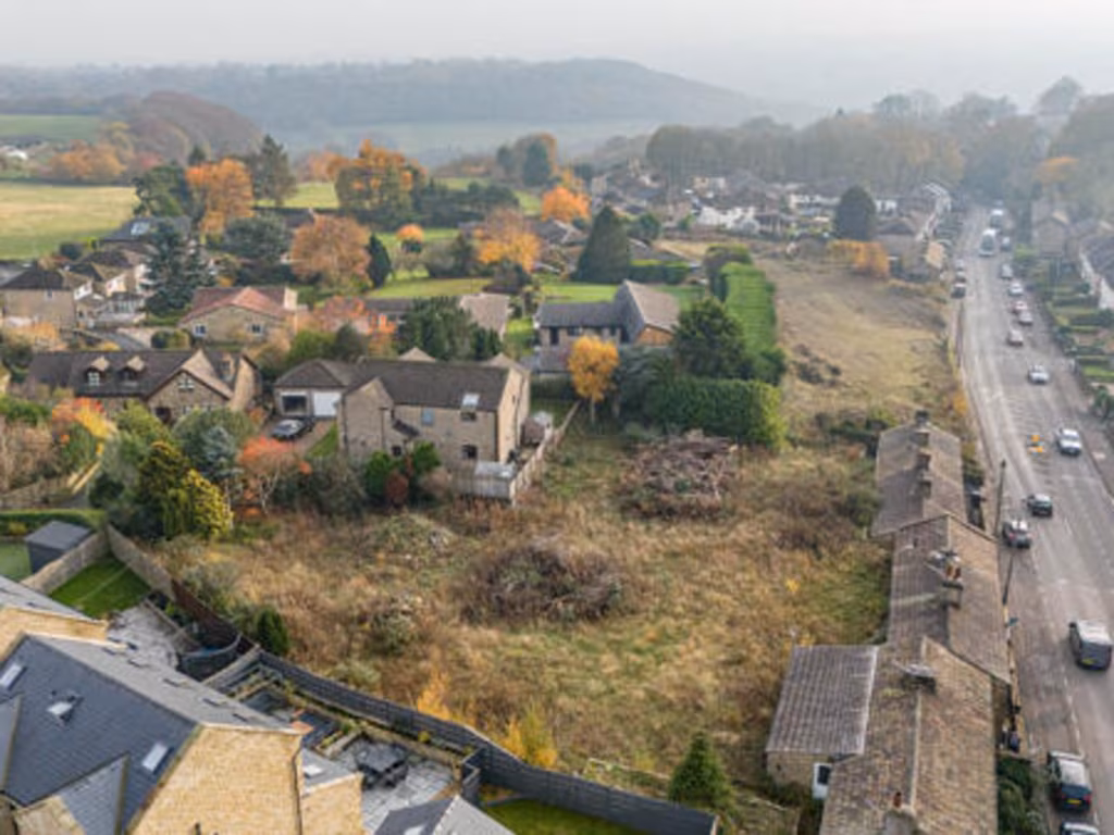
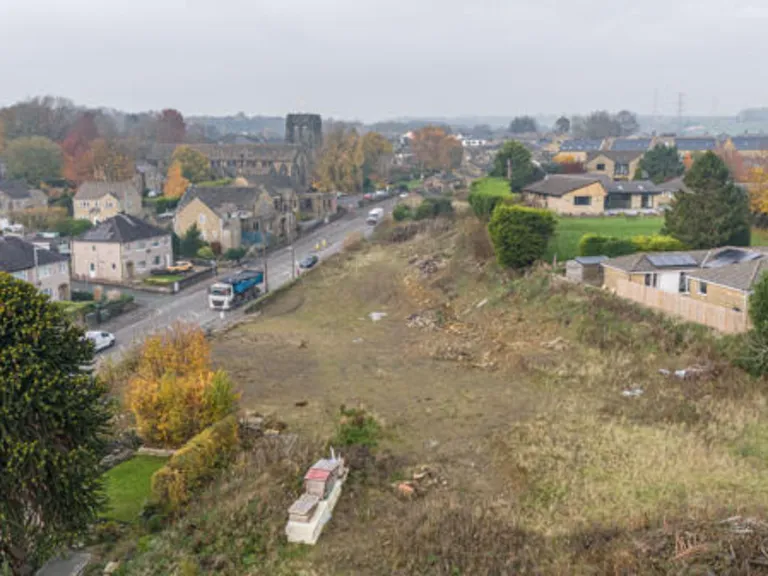
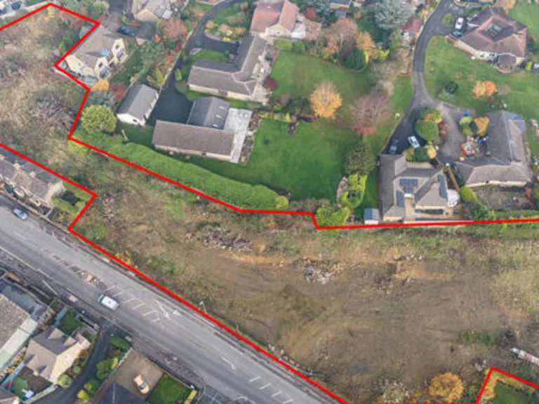
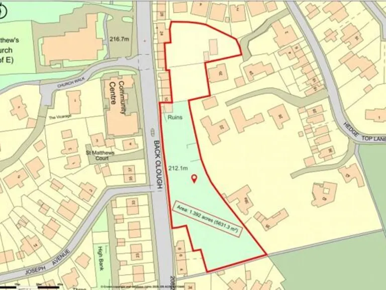
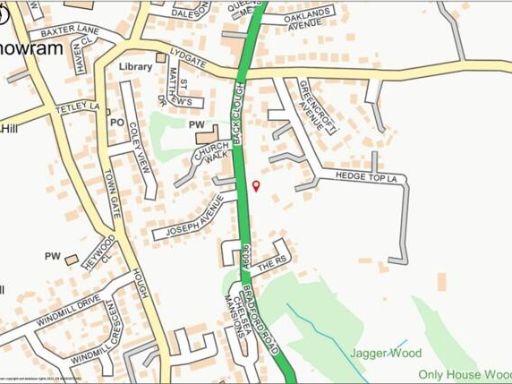
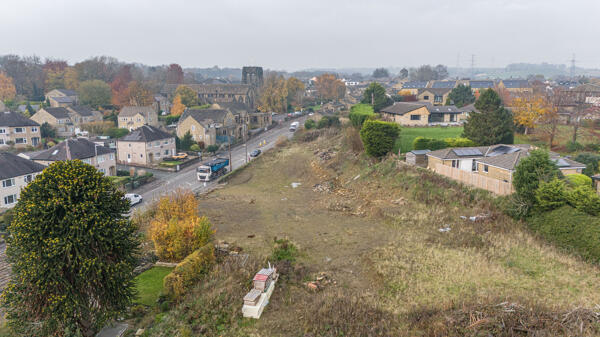
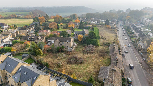
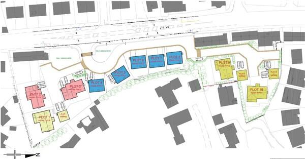
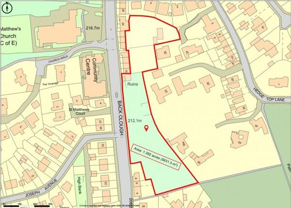
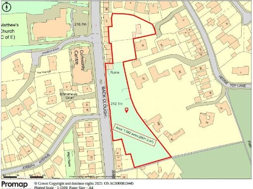
- Valuator-style description: A development parcel of land situated on a sloping, elevated site adjacent to Bradford Road in Northowram. The site extends to approximately 1.392 acres (0.56 hectares) and benefits from planning consent for the construction of 10 detached houses. The plot is irregular in shape with a visible fall from the road down into the site, offering potential for dwellings with elevated outlooks over the surrounding townscape. Immediate context is residential with nearby bungalows and houses, a church and local road frontage to the A6036 (Bradford Road). Vehicular access is direct from Bradford Road. The site is of a size classed as large for a single residential development plot and would be suitable for medium-density suburban housing development subject to planning compliance. Local commuter links (M62 and rail) are noted as strong.
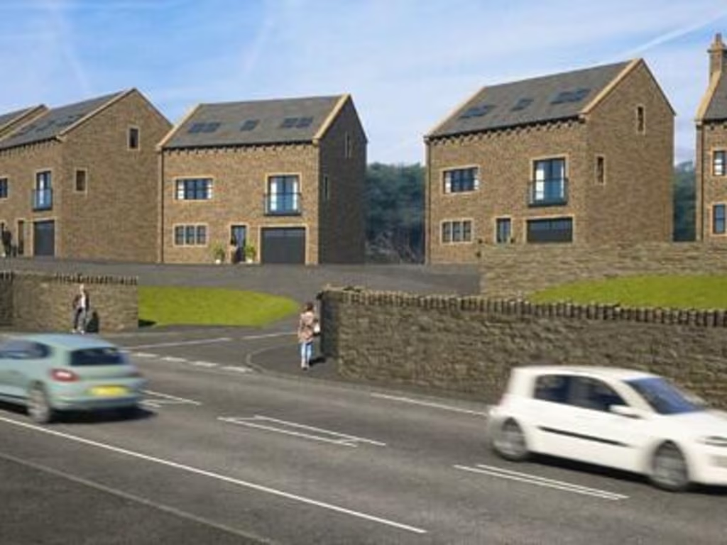
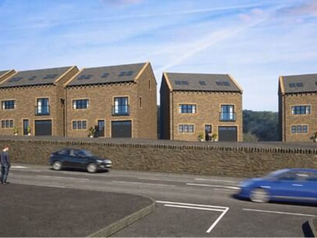
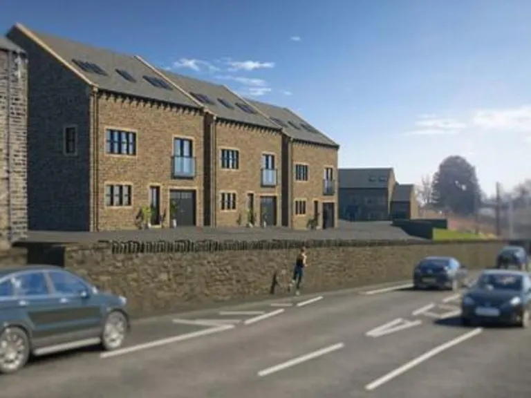
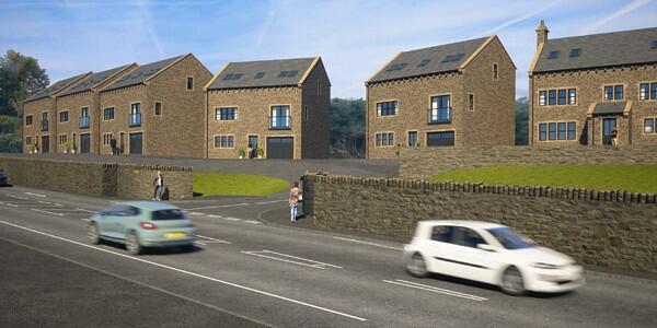
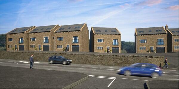
- New-build development of stone-built houses illustrated in marketing visuals. Properties appear as two to three storeys with pitched slate roofs and dormer/rooflight windows; a mix of semi‑detached and detached house forms is shown. The site sits directly off a main road (retaining wall and pavement visible) with modest front lawns and tiered levels on sloping ground; a site plan suggests a small cul-de-sac/cluster layout with landscaped buffer strips. Overall accommodation is likely medium-to-large for family use (probable 3–4 bedroom homes) with average-sized rear gardens and limited driveway/parking adjacent to each unit. Views are mainly of the roadside and nearby semi-rural/wooded land in the distance. Proportions and materials indicate a higher-quality new build in keeping with local vernacular.
Image Descriptions
- land plot
- property development site modern
Textual Property Features
Detected Visual Features
- land
- plot
- development opportunity
- vacant
- residential area
- potential
- property development
- investment
- modern houses
- garden
- accessible roads
Nearby Schools
- Siddal Primary School
- Brighouse High School
- Cliffe Hill Community Primary School
- Trinity Academy Bradford
- Buttershaw Business & Enterprise College Academy
- Home Farm Primary School
- St John the Evangelist Catholic Primary School
- St Joseph's Catholic Primary Academy
- Trinity Academy Akroydon
- Salterlee Primary School
- Shelf Junior and Infant School
- Jaamiatul Imaam Muhammad Zakaria
- Trinity Academy St Chad's
- Lightcliffe Academy
- Lightcliffe C of E Primary School
- Beech Hill School
- Hipperholme Grammar School
- Northowram Primary School
- St Michael and All Angels CofE Primary & Pre School
- Russell Hall Primary School
- Reevy Hill Primary School
- Stocks Lane Primary School
- Foxhill Primary School
- Salterhebble Junior and Infant School
- Withinfields Primary School
- St Joseph's Catholic Primary Academy
- Farfield Primary and Nursery School
- Shibden Head Primary Academy
Nearest Bars And Restaurants
- Id: 431888411
- Tags:
- Addr:
- City: Halifax
- Country: GB
- Hamlet: Hipperholme
- Postcode: HX3 8JQ
- Street: Denholme Gate Road
- Amenity: pub
- Fhrs:
- Name: The Hare & Hounds
- Source:
- TagsNormalized:
- Lat: 53.7293116
- Lon: -1.8143318
- FullGeoHash: gcw9wtnggj85
- PartitionGeoHash: gcw9
- Images:
- FoodStandards: null
- Distance: 1258.3
,- Id: 511124952
- Tags:
- Addr:
- Housenumber: 2
- Postcode: HX3 7LN
- Street: West Street
- Village: Shelf
- Amenity: pub
- Fhrs:
- Name: Duke of York
- Source: photograph
- Source:addr: FHRS Open Data
- Wikidata: Q26426706
- TagsNormalized:
- Lat: 53.7476995
- Lon: -1.823826
- FullGeoHash: gcw9y2rzjc2u
- PartitionGeoHash: gcw9
- Images:
- FoodStandards: null
- Distance: 1243.8
,- Id: 665170447
- Tags:
- Amenity: cafe
- Building: yes
- Outdoor_seating: yes
- TagsNormalized:
- Lat: 53.7306155
- Lon: -1.8374034
- FullGeoHash: gcw9wjq592sw
- PartitionGeoHash: gcw9
- Images:
- FoodStandards: null
- Distance: 906.5
,- Id: 150475156
- Tags:
- Amenity: restaurant
- Building: yes
- Food: yes
- Name: The Brown Horse
- Phone: +44 1422 202112
- Source: photograph
- TagsNormalized:
- Lat: 53.7381975
- Lon: -1.8154486
- FullGeoHash: gcw9wwwp8yp6
- PartitionGeoHash: gcw9
- Images:
- FoodStandards: null
- Distance: 875.3
,- Id: 450756829
- Tags:
- Addr:
- City: Halifax
- Country: GB
- Hamlet: Northowram
- Housenumber: 1
- Postcode: HX3 7EA
- Street: Towngate
- Amenity: pub
- Fhrs:
- Name: Shoulder of Mutton
- Source:
- TagsNormalized:
- Lat: 53.7380947
- Lon: -1.8318481
- FullGeoHash: gcw9wqdp4fgj
- PartitionGeoHash: gcw9
- Images:
- FoodStandards: null
- Distance: 255.2
}
Nearest General Shops
- Id: 118710058
- Tags:
- Addr:
- City: Halifax
- Country: GB
- Postcode: HX3 6AB
- Street: Charlestown Road
- Brand: Next
- Brand:wikidata: Q246655
- Brand:wikipedia: en:Next plc
- Building: yes
- Name: Next
- Shop: clothes
- TagsNormalized:
- Lat: 53.7260169
- Lon: -1.8521329
- FullGeoHash: gcw9tue2dpmw
- PartitionGeoHash: gcw9
- Images:
- FoodStandards: null
- Distance: 1964.6
,- Id: 1874119198
- Tags:
- Name: BBeauty Lounge
- Phone: +44 1422 208400
- Shop: beauty
- Website: http://www.bbeautylounge.co.uk/
- TagsNormalized:
- Lat: 53.7256647
- Lon: -1.8117647
- FullGeoHash: gcw9wu2wwvf3
- PartitionGeoHash: gcw9
- Images:
- FoodStandards: null
- Distance: 1665.6
,- Id: 413494627
- Tags:
- Name: Halifax Volkswagen
- Shop: car
- TagsNormalized:
- Lat: 53.7470215
- Lon: -1.8217143
- FullGeoHash: gcw9y837nfzr
- PartitionGeoHash: gcw9
- Images:
- FoodStandards: null
- Distance: 1215.3
}
Nearest Grocery shops
- Id: 359502831
- Tags:
- Brand: Co-op Food
- Brand:wikidata: Q3277439
- Brand:wikipedia: en:Co-op Food
- Building: yes
- Name: Co-op Food
- Operator: The Co-operative Group
- Shop: convenience
- TagsNormalized:
- co-op
- co-op food
- food
- convenience
- shop
- Lat: 53.7263731
- Lon: -1.8129524
- FullGeoHash: gcw9wsxfg1ue
- PartitionGeoHash: gcw9
- Images:
- FoodStandards: null
- Distance: 1554.8
,- Id: 559917374
- Tags:
- Building: retail
- Shop: convenience
- TagsNormalized:
- Lat: 53.730823
- Lon: -1.8432568
- FullGeoHash: gcw9wj3u9p25
- PartitionGeoHash: gcw9
- Images:
- FoodStandards: null
- Distance: 1177.2
,- Id: 391577797
- Tags:
- Amenity: fuel
- Name: Headlands
- Operator: murco
- Shop: convenience
- TagsNormalized:
- Lat: 53.7301369
- Lon: -1.8153274
- FullGeoHash: gcw9wtq0ez3z
- PartitionGeoHash: gcw9
- Images:
- FoodStandards: null
- Distance: 1148.5
}
Nearest Supermarkets
- Id: 202093191
- Tags:
- Addr:
- City: Halifax
- Country: GB
- Housenumber: 83
- Postcode: HX3 6ED
- Street: Haley Hill
- Brand: Lidl
- Brand:wikidata: Q151954
- Building: supermarket
- Building:levels: 1
- Fhrs:
- Name: Lidl
- Payment:
- Coins: yes
- Maestro: yes
- Mastercard: yes
- Notes: yes
- Visa: yes
- Visa_debit: yes
- Visa_electron: yes
- Shop: supermarket
- Source: Bing
- Source:addr: FHRS Open Data
- Wheelchair: yes
- TagsNormalized:
- Lat: 53.7292548
- Lon: -1.8628824
- FullGeoHash: gcw9tt57xen1
- PartitionGeoHash: gcw9
- Images:
- FoodStandards: null
- Distance: 2410.8
,- Id: 108382826
- Tags:
- Addr:
- City: Halifax
- Country: GB
- Postcode: HX1 1SB
- Street: Wade Street
- Brand: Sainsbury's
- Brand:wikidata: Q152096
- Brand:wikipedia: en:Sainsbury's
- Building: yes
- Fhrs:
- Name: Sainsbury's
- Shop: supermarket
- Source:
- Website: https://stores.sainsburys.co.uk/0778/halifax
- TagsNormalized:
- sainsburys
- supermarket
- shop
- Lat: 53.7257087
- Lon: -1.855886
- FullGeoHash: gcw9tu2wftzp
- PartitionGeoHash: gcw9
- Images:
- FoodStandards: null
- Distance: 2184
,- Id: 559917377
- Tags:
- Brand: Sainsbury's
- Brand:wikidata: Q152096
- Brand:wikipedia: en:Sainsbury's
- Building: yes
- Name: Sainsbury's
- Note: Petrol station shop attached to a larger store
- Shop: supermarket
- Website: https://stores.sainsburys.co.uk/0778/halifax
- TagsNormalized:
- sainsburys
- supermarket
- shop
- Lat: 53.726369
- Lon: -1.8547003
- FullGeoHash: gcw9tu96y354
- PartitionGeoHash: gcw9
- Images:
- FoodStandards: null
- Distance: 2078.2
}
Nearest Religious buildings
- Id: 565369436
- Tags:
- Amenity: place_of_worship
- Building: yes
- Name: Christ Church Hipperholme & Lightcliffe
- Religion: christian
- TagsNormalized:
- place of worship
- church
- christian
- Lat: 53.7252698
- Lon: -1.8122601
- FullGeoHash: gcw9wu2k7k0v
- PartitionGeoHash: gcw9
- Images:
- FoodStandards: null
- Distance: 1677.7
,- Id: 206123342
- Tags:
- Amenity: place_of_worship
- Building: church
- Denomination: anglican
- Name: St John the Baptist
- Religion: christian
- Wikidata: Q26426812
- TagsNormalized:
- place of worship
- church
- anglican
- baptist
- christian
- Lat: 53.7385725
- Lon: -1.812366
- FullGeoHash: gcw9wyb3bgcz
- PartitionGeoHash: gcw9
- Images:
- FoodStandards: null
- Distance: 1082.2
,- Id: 204964971
- Tags:
- Amenity: place_of_worship
- Building: church
- Denomination: anglican
- Name: Northowram Church
- Religion: christian
- Source: Local knowledge / Bing
- Wikidata: Q26426956
- TagsNormalized:
- place of worship
- church
- anglican
- christian
- Lat: 53.7387378
- Lon: -1.8293521
- FullGeoHash: gcw9wqgfv4b1
- PartitionGeoHash: gcw9
- Images:
- FoodStandards: null
- Distance: 213.9
}
Nearest Medical buildings
- Id: 854043053
- Tags:
- Amenity: clinic
- Building: yes
- Building:levels: 3
- Healthcare: clinic
- Name: Laura Mitchell Health & Wellbeing Centre
- Operator: NHS
- Operator:type: public
- TagsNormalized:
- Lat: 53.7248922
- Lon: -1.8629221
- FullGeoHash: gcw9ts76nvb9
- PartitionGeoHash: gcw9
- Images:
- FoodStandards: null
- Distance: 2623.2
,- Id: 5502173701
- Tags:
- Addr:
- City: Halifax
- Country: GB
- Housenumber: 7-11
- Postcode: HX1 1PB
- Street: Market Street
- Amenity: pharmacy
- Brand: Boots
- Brand:wikidata: Q6123139
- Brand:wikipedia: en:Boots (company)
- Dispensing: yes
- Healthcare: pharmacy
- Name: Boots
- Operator: Boots
- Ref: 1039558
- TagsNormalized:
- pharmacy
- boots
- health
- healthcare
- Lat: 53.7228881
- Lon: -1.8587735
- FullGeoHash: gcw9teyqx2nn
- PartitionGeoHash: gcw9
- Images:
- FoodStandards: null
- Distance: 2523.1
,- Id: 8411731722
- Tags:
- Amenity: dentist
- Brand: mydentist
- Brand:wikidata: Q65118035
- Healthcare: dentist
- Name: mydentist
- TagsNormalized:
- Lat: 53.7248641
- Lon: -1.8604326
- FullGeoHash: gcw9tsm60b8c
- PartitionGeoHash: gcw9
- Images:
- FoodStandards: null
- Distance: 2485.2
,- Id: 957606806
- Tags:
- Amenity: doctors
- Building: yes
- Healthcare: doctor
- TagsNormalized:
- doctor
- doctors
- health
- healthcare
- Lat: 53.7301625
- Lon: -1.8644486
- FullGeoHash: gcw9tt62ghnr
- PartitionGeoHash: gcw9
- Images:
- FoodStandards: null
- Distance: 2475.3
}
Nearest Airports
- Id: 11519546
- Tags:
- Addr:
- City: Leeds
- Postcode: LS19 7TU
- Aerodrome: international
- Aerodrome:type: public
- Aeroway: aerodrome
- Iata: LBA
- Icao: EGNM
- Name: Leeds Bradford Airport
- Operator: Leeds Bradford Airport Limited
- Operator:type: private
- Ref: LBA
- Type: multipolygon
- Website: https://www.leedsbradfordairport.co.uk/
- Wikidata: Q8699
- Wikipedia: en:Leeds Bradford Airport
- TagsNormalized:
- airport
- international airport
- Lat: 53.8667047
- Lon: -1.660138
- FullGeoHash: gcwf6nph7cx3
- PartitionGeoHash: gcwf
- Images:
- Q8699-1
- Q8699-2
- Q8699-3
- Q8699-4
- FoodStandards: null
- Distance: 18186.8
}
Nearest Leisure Facilities
- Id: 403107216
- Tags:
- Leisure: pitch
- Source: Bing
- Sport: rugby_union
- TagsNormalized:
- pitch
- leisure
- rugby
- rugby union
- sports
- Lat: 53.7312592
- Lon: -1.8173105
- FullGeoHash: gcw9wtkxm8ej
- PartitionGeoHash: gcw9
- Images:
- FoodStandards: null
- Distance: 968.3
,- Id: 911266755
- Tags:
- Leisure: pitch
- Sport: rugby_union
- TagsNormalized:
- pitch
- leisure
- rugby
- rugby union
- sports
- Lat: 53.7306561
- Lon: -1.8189912
- FullGeoHash: gcw9wt77y2mb
- PartitionGeoHash: gcw9
- Images:
- FoodStandards: null
- Distance: 935
,- Id: 204977310
- Tags:
- Leisure: pitch
- Source: Bing
- Sport: cricket
- TagsNormalized:
- pitch
- leisure
- cricket
- sports
- Lat: 53.7392459
- Lon: -1.8240857
- FullGeoHash: gcw9wqztz9x0
- PartitionGeoHash: gcw9
- Images:
- FoodStandards: null
- Distance: 395.7
,- Id: 204976961
- Tags:
- Leisure: pitch
- Source: Bing
- Sport: cricket
- TagsNormalized:
- pitch
- leisure
- cricket
- sports
- Lat: 53.7385121
- Lon: -1.8238736
- FullGeoHash: gcw9wqzcs8tr
- PartitionGeoHash: gcw9
- Images:
- FoodStandards: null
- Distance: 358.6
,- Id: 731989940
- Tags:
- Leisure: pitch
- Name: Northowram Crown Green Bowls Club
- Sport: bowls
- TagsNormalized:
- pitch
- leisure
- bowls
- club
- sports
- Lat: 53.7359541
- Lon: -1.830286
- FullGeoHash: gcw9wq74x5zu
- PartitionGeoHash: gcw9
- Images:
- FoodStandards: null
- Distance: 152.2
}
Nearest Tourist attractions
- Id: 183981646
- Tags:
- Building: yes
- Opening_hours: Tu-Sa 10:00-16:00; BH 10:00-16:00
- Tourism: museum
- Wikidata: Q4856277
- Wikipedia: en:Bankfield Museum
- TagsNormalized:
- Lat: 53.732533
- Lon: -1.8633319
- FullGeoHash: gcw9ttentnph
- PartitionGeoHash: gcw9
- Images:
- FoodStandards: null
- Distance: 2337
,- Id: 2162905189
- Tags:
- Addr:
- City: Halifax
- Housename: Shibden Hall
- Postcode: HX3 6XG
- Street: Lister's Road
- Museum: history
- Name: Shibden Hall
- Operator: Calderdale Museums
- Tourism: museum
- Website: https://museums.calderdale.gov.uk/visit/shibden-hall
- TagsNormalized:
- Lat: 53.7281552
- Lon: -1.8399129
- FullGeoHash: gcw9whujnyj9
- PartitionGeoHash: gcw9
- Images:
- FoodStandards: null
- Distance: 1223.2
,- Id: 361229184
- Tags:
- Name: Shibden Estate
- Tourism: attraction
- TagsNormalized:
- Lat: 53.7299643
- Lon: -1.8372346
- FullGeoHash: gcw9wjnptr69
- PartitionGeoHash: gcw9
- Images:
- FoodStandards: null
- Distance: 956.5
}
Nearest Hotels
- Id: 174074958
- Tags:
- Brand: Premier Inn
- Brand:wikidata: Q2108626
- Building: yes
- Internet_access: wlan
- Internet_access:fee: customers
- Internet_access:operator: Virgin Media
- Internet_access:ssid: Premier Inn Free Wi-Fi
- Name: Premier Inn Halifax Town Centre
- Tourism: hotel
- TagsNormalized:
- premier
- inn
- halifax
- hotel
- tourism
- Lat: 53.7252407
- Lon: -1.8614838
- FullGeoHash: gcw9tsks0qc0
- PartitionGeoHash: gcw9
- Images:
- FoodStandards: null
- Distance: 2522.1
,- Id: 118508271
- Tags:
- Addr:
- City: Halifax
- Country: GB
- Housenumber: 42-46
- Postcode: HX1 1QE
- Street: Horton Street
- Building: yes
- Fax: +44 870 6996114
- Fhrs:
- Fixme: FHRS quotes street Square Road. Other things quote Horton street.
- Name: Imperial Crown Hotel
- Phone: +44 1422 349866
- Rooms: 56
- Tourism: hotel
- Website: www.imperialcrownhotel.co.uk
- TagsNormalized:
- Lat: 53.7213494
- Lon: -1.8556674
- FullGeoHash: gcw9tg8txc65
- PartitionGeoHash: gcw9
- Images:
- FoodStandards: null
- Distance: 2481.3
,- Id: 118583365
- Tags:
- Addr:
- City: Halifax
- Country: GB
- Housenumber: 5
- Postcode: HX1 1SP
- Street: Multcture Hall Road
- Bar: yes
- Building: hotel
- Building:levels: 4
- Email: info@woolmerchanthotel.co.uk
- Fhrs:
- Internet_access: yes
- Name: Wool Merchant Hotel
- Pets_allowed: no
- Phone: +44 1422 368783
- Rooms: 55
- Smoking: no
- Stars: 3
- Tourism: hotel
- Website: https://woolmerchanthotel.co.uk/
- TagsNormalized:
- Lat: 53.7240802
- Lon: -1.8539778
- FullGeoHash: gcw9tu1vrnmv
- PartitionGeoHash: gcw9
- Images:
- FoodStandards: null
- Distance: 2194.8
}
Tags
- land
- plot
- development opportunity
- vacant
- residential area
- potential
- property development
- land
- residential area
- investment
- modern houses
- garden
- accessible roads
Local Market Stats
- Average Price/sqft: £191
- Avg Income: £38200
- Rental Yield: 3.9%
- Social Housing: 8%
- Planning Success Rate: 84%
AirBnB Data
- 1km average: £95/night
- Listings in 1km: 1
Similar Properties
 Land for sale in Land at Back Clough, Northowram, Halifax, HX3 — £1,350,000 • 1 bed • 1 bath
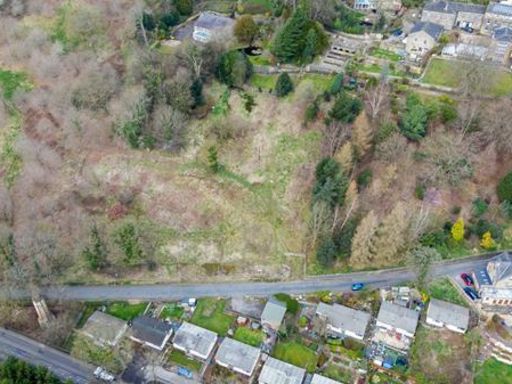 Land for sale in Residential Development Site, Lower Brockwell Lane, Sowerby Bridge, HX6 — £1,000,000 • 1 bed • 1 bath
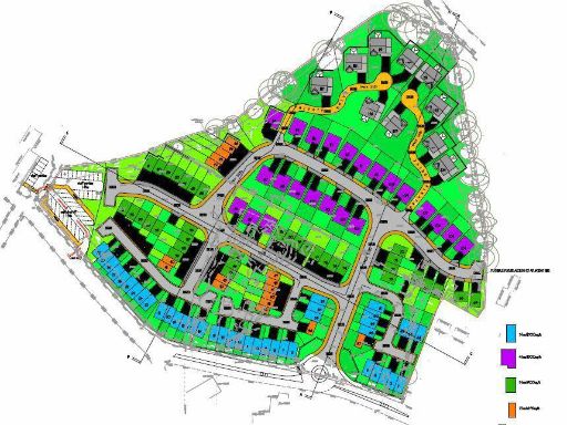 Land for sale in Albert Road, Queensbury, Bradford, BD13 1PL, BD13 — POA • 1 bed • 1 bath
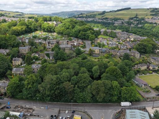 Land for sale in Land at Jerry Lane, Sowerby Bridge, Halifax, HX6 — £600,000 • 1 bed • 1 bath
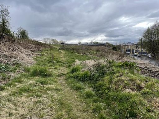 Land for sale in Land Adjacent To Emstead Works, Old Lane, Halifax, HX3 — £650,000 • 1 bed • 1 bath
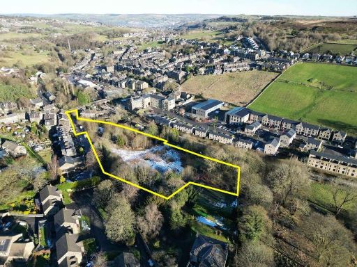 Land for sale in Land at Ivy Bank Lane, Haworth, Keighley, BD22 — £1,250,000 • 1 bed • 1 bath
Meta
- {
"@context": "https://schema.org",
"@type": "Residence",
"name": "Land for sale in Land At Back Clough, Bradford Road, Northo…",
"description": "",
"url": "https://propertypiper.co.uk/property/81abce75-53de-45ad-be43-84b0c494d17d",
"image": "https://image-a.propertypiper.co.uk/bc6f6f83-f182-4419-be82-10a634ec65fa-1024.jpeg",
"address": {
"@type": "PostalAddress",
"streetAddress": "7 BACK CLOUGH HALIFAX",
"postalCode": "HX3 7HH",
"addressLocality": "Calderdale",
"addressRegion": "Halifax",
"addressCountry": "England"
},
"geo": {
"@type": "GeoCoordinates",
"latitude": 53.73687081145608,
"longitude": -1.8285665645704166
},
"numberOfRooms": 1,
"numberOfBathroomsTotal": 1,
"offers": {
"@type": "Offer",
"price": 1350000,
"priceCurrency": "GBP",
"availability": "https://schema.org/InStock"
},
"additionalProperty": [
{
"@type": "PropertyValue",
"name": "Feature",
"value": "land"
},
{
"@type": "PropertyValue",
"name": "Feature",
"value": "plot"
},
{
"@type": "PropertyValue",
"name": "Feature",
"value": "development opportunity"
},
{
"@type": "PropertyValue",
"name": "Feature",
"value": "vacant"
},
{
"@type": "PropertyValue",
"name": "Feature",
"value": "residential area"
},
{
"@type": "PropertyValue",
"name": "Feature",
"value": "potential"
},
{
"@type": "PropertyValue",
"name": "Feature",
"value": "property development"
},
{
"@type": "PropertyValue",
"name": "Feature",
"value": "land"
},
{
"@type": "PropertyValue",
"name": "Feature",
"value": "residential area"
},
{
"@type": "PropertyValue",
"name": "Feature",
"value": "investment"
},
{
"@type": "PropertyValue",
"name": "Feature",
"value": "modern houses"
},
{
"@type": "PropertyValue",
"name": "Feature",
"value": "garden"
},
{
"@type": "PropertyValue",
"name": "Feature",
"value": "accessible roads"
}
]
}