BD20 8LT - 3 bedroom terraced house for sale in Aireside, Cononley, BD…
View on Property Piper
3 bedroom terraced house for sale in Aireside, Cononley, BD20
Property Details
- Price: £240000
- Bedrooms: 3
- Bathrooms: 2
- Property Type: undefined
- Property SubType: undefined
Image Descriptions
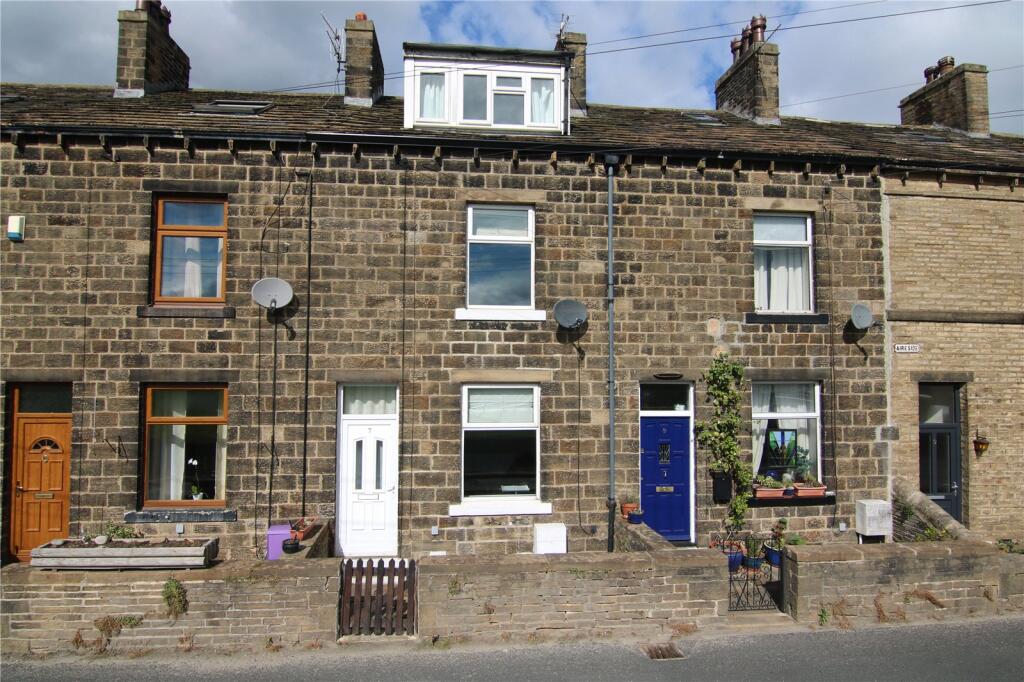
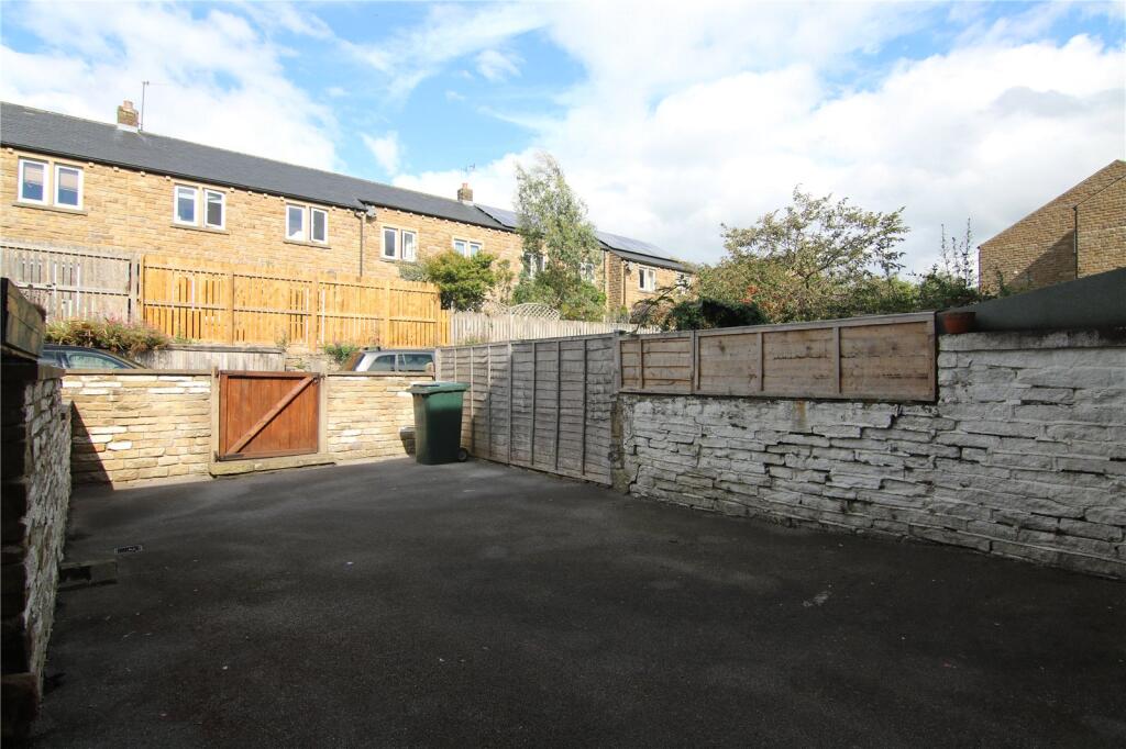
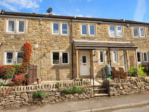
- 1900s terraced house Victorian terrace
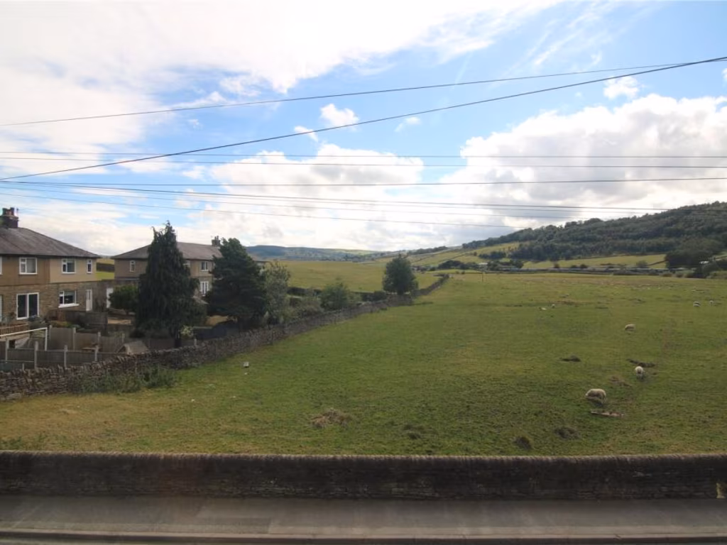
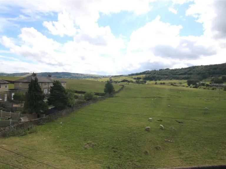
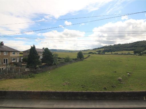
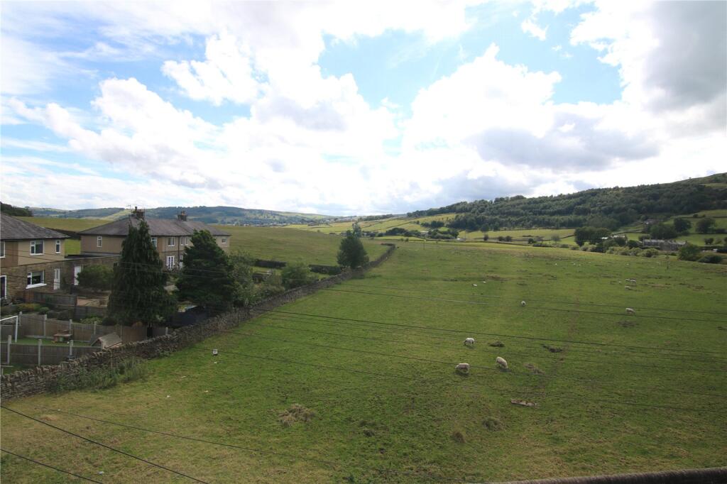
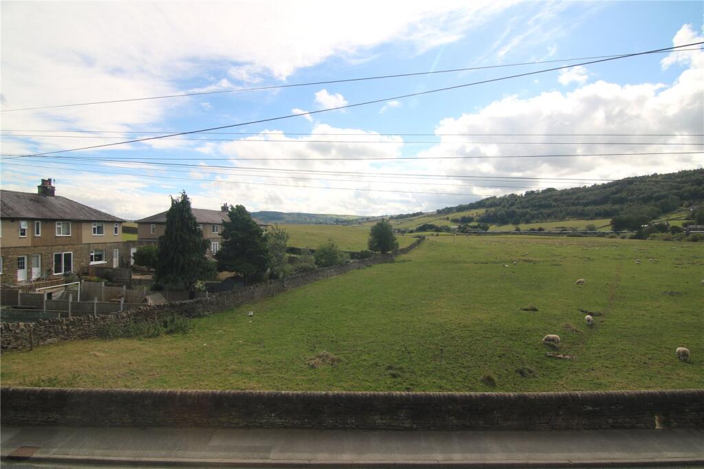
- rural landscape
Floorplan Description
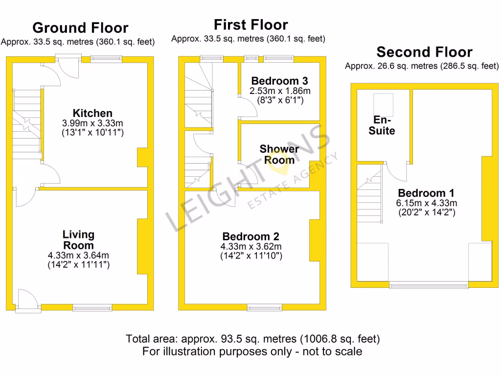
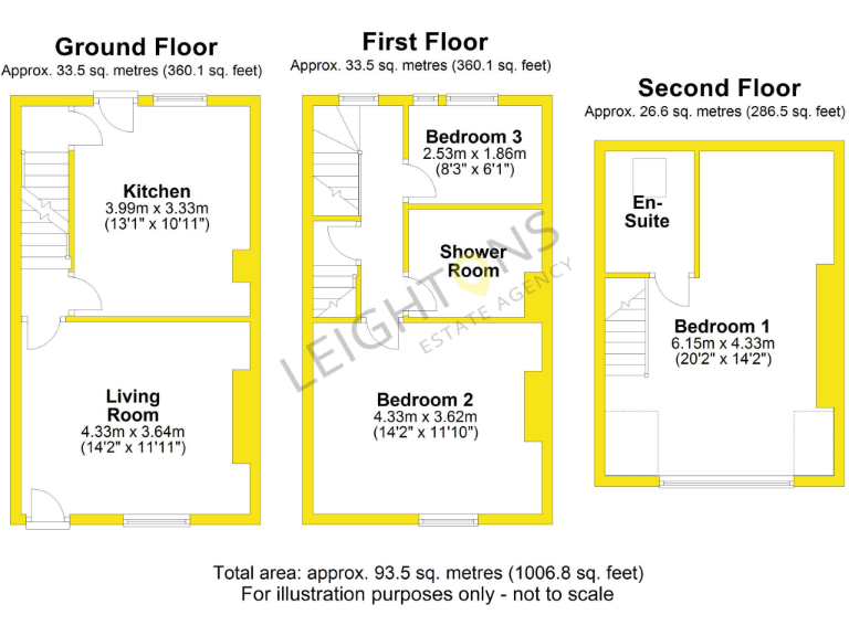
- Floor plan showing rooms and dimensions across three floors
Rooms
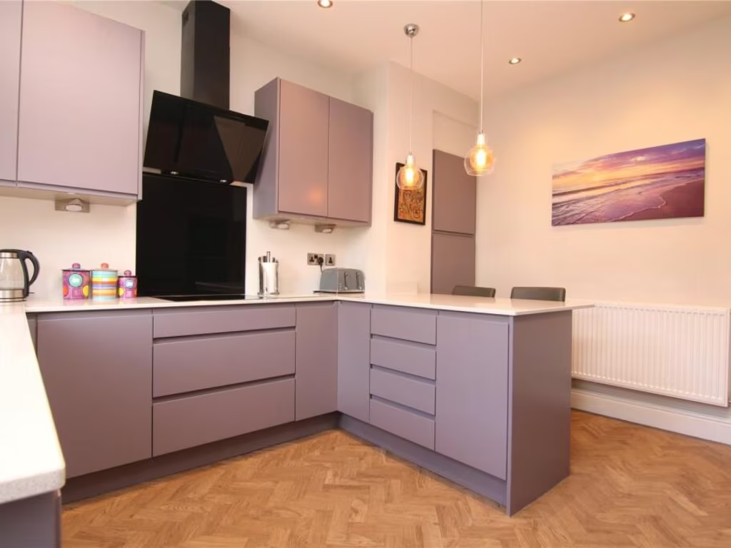
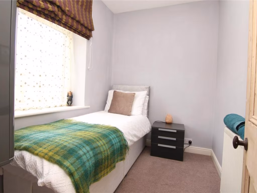
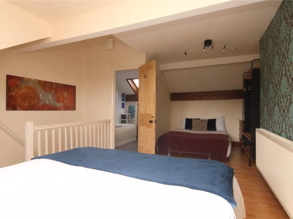
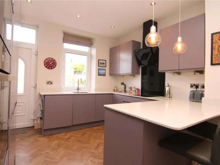
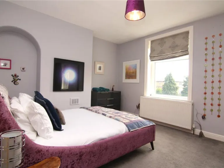
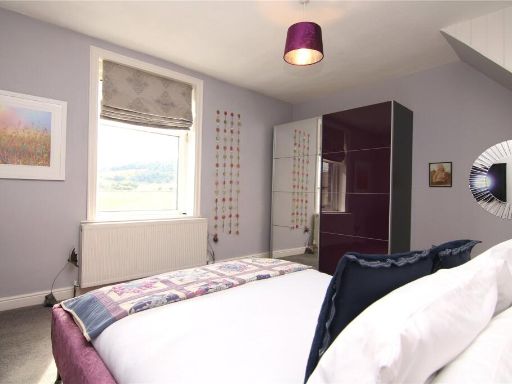
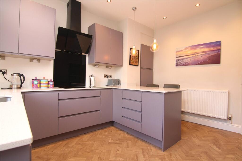
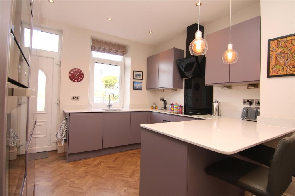
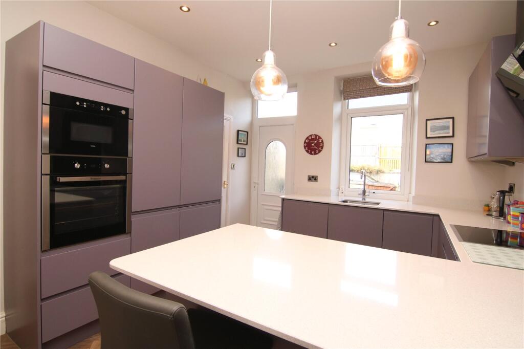
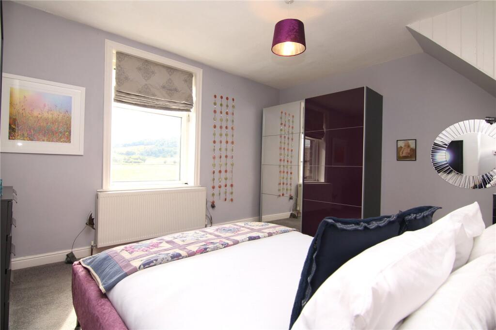
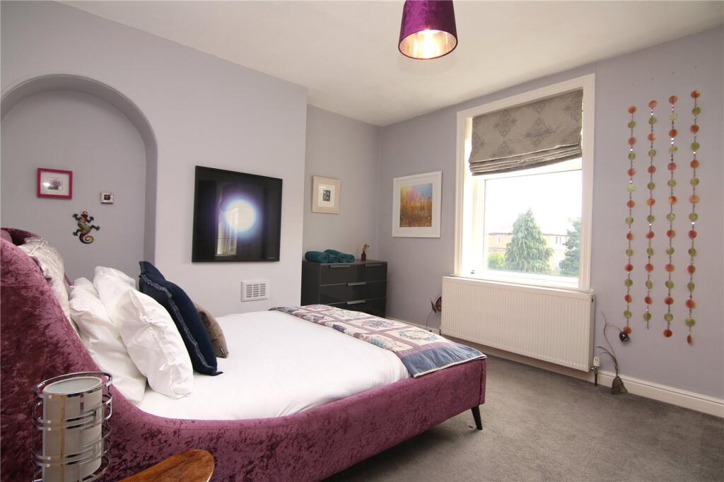
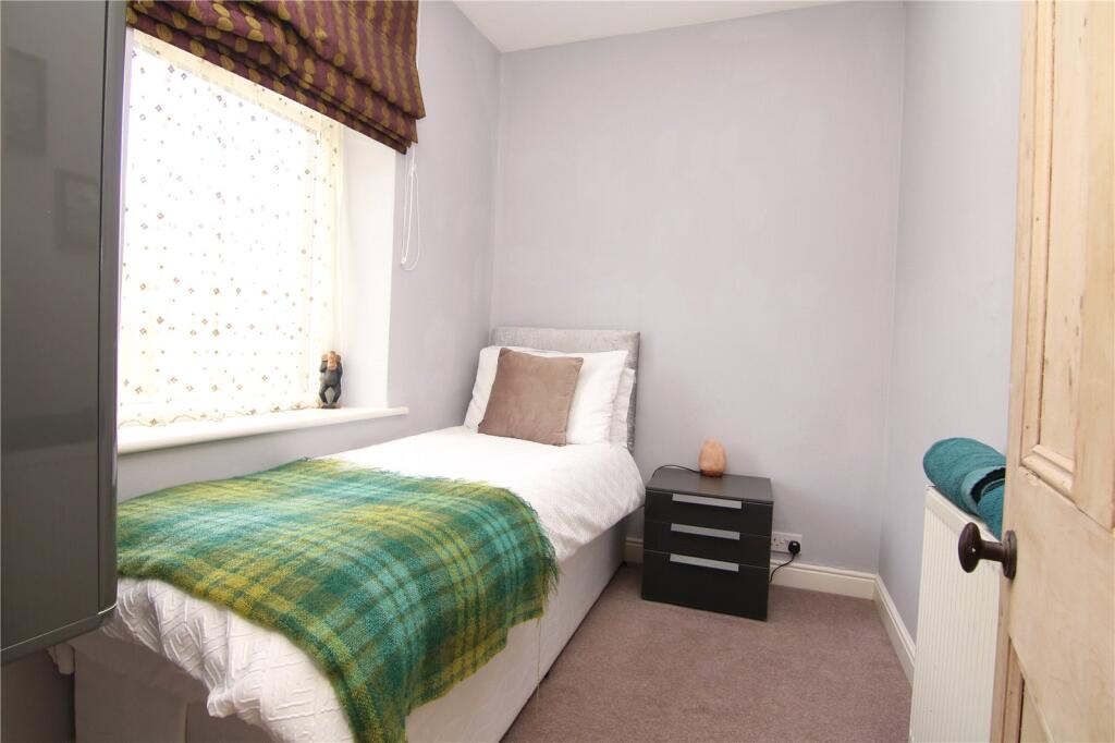
- Kitchen:
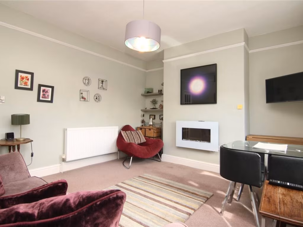
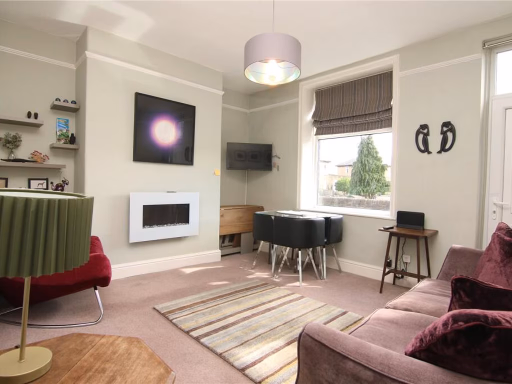
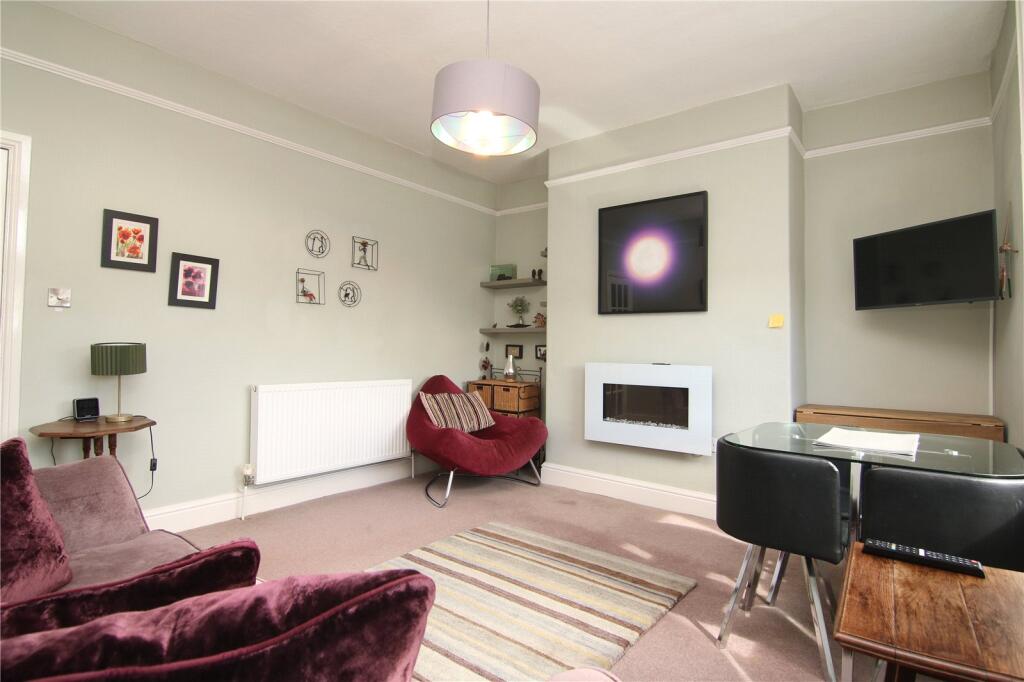
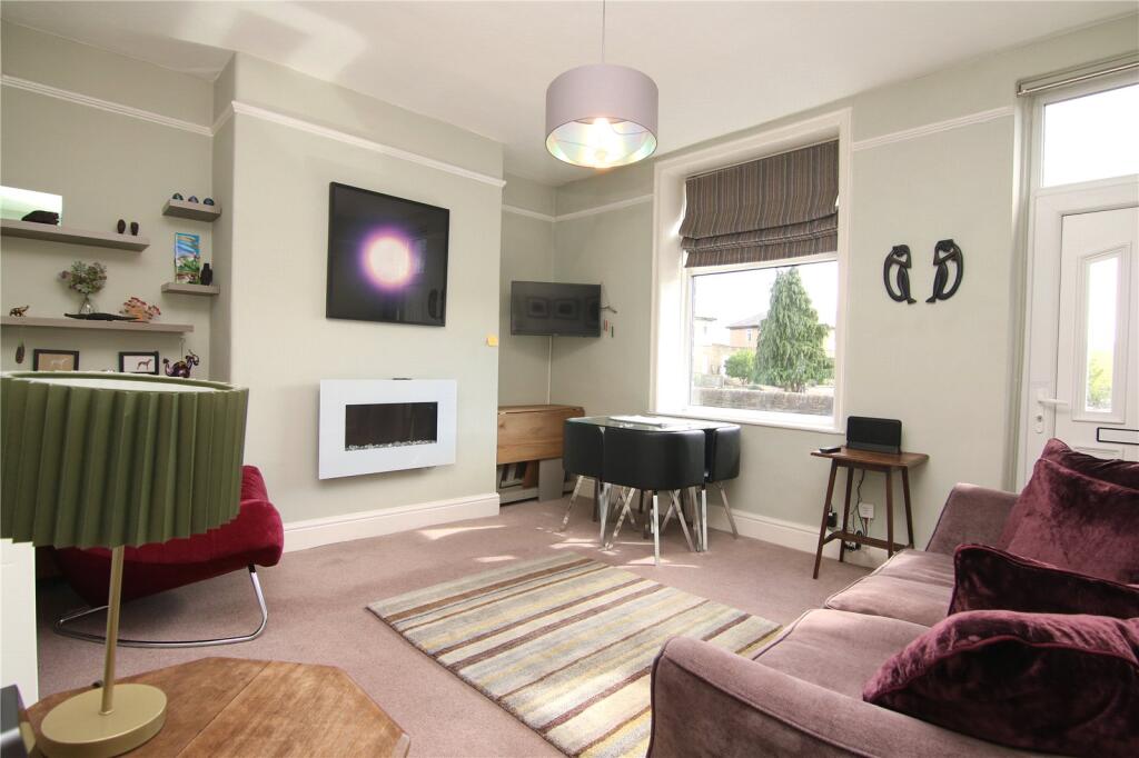
- Living Room:
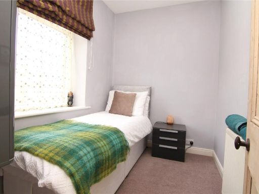
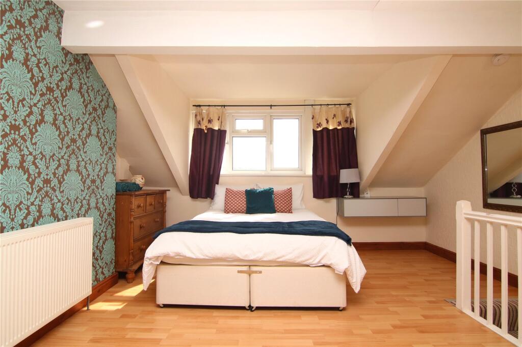
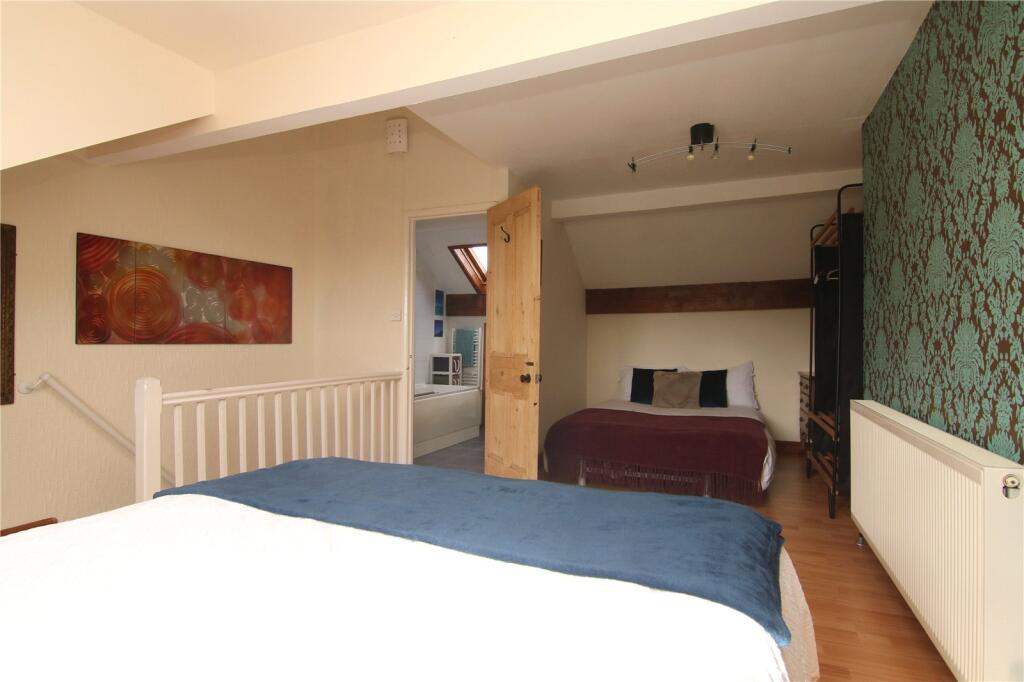
- Bedroom 2:
- Bedroom 3:
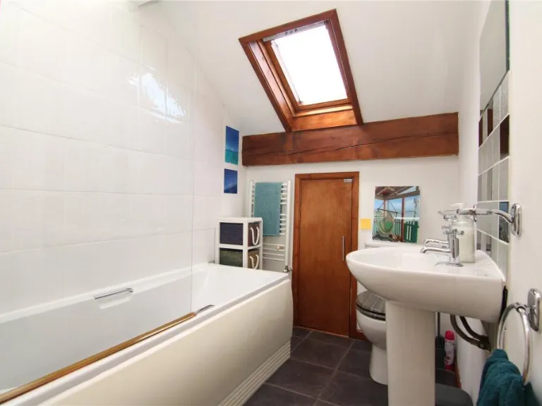
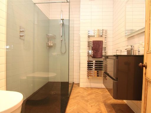
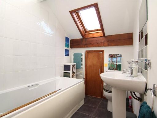
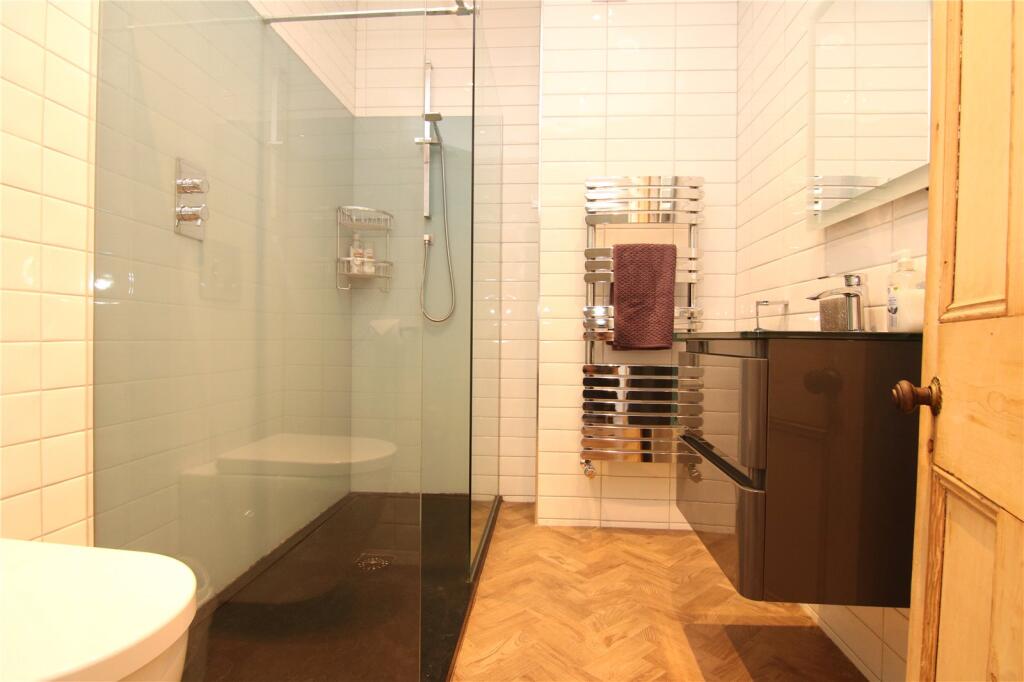
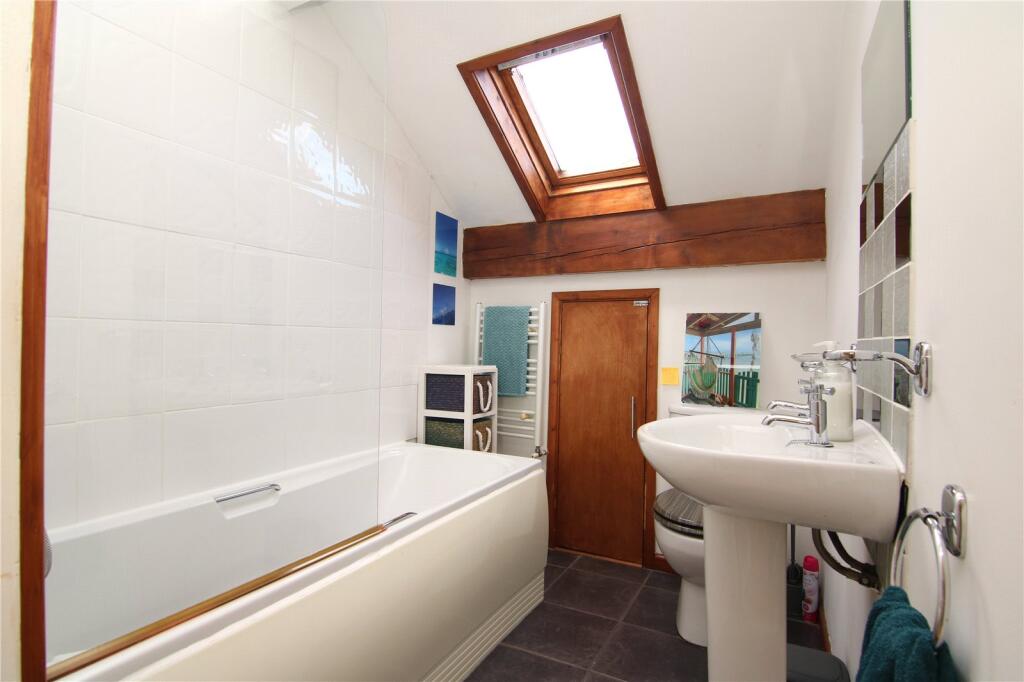
- Shower Room:
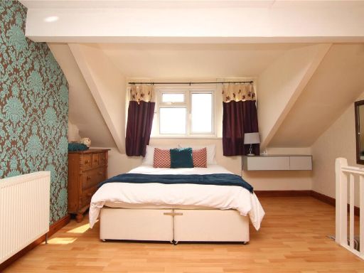
- Bedroom 1:
- En-Suite:
Textual Property Features
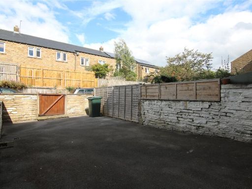
- Has Garden
- Chain Free
- Success
Detected Visual Features
- Victorian
- terraced
- period property
- stone
- historic
- three stories
- front garden
- no garage
- traditional style
- period features
- rural
- landscape
- countryside
- pasture
- nature
- scenic
- quiet
- views
EPC Details
- Fully double glazed
- Sandstone or limestone, as built, no insulation (assumed)
- Boiler and radiators, mains gas
- Low energy lighting in 88% of fixed outlets
- Solid, no insulation (assumed)
Nearby Schools
- Oakworth Primary School
- Sutton-in-Craven Community Primary School
- Steeton Primary School
- South Craven School
- Kildwick Church of England Voluntary Controlled Primary School
- Silsden Primary School
- Embsay Church of England Voluntary Controlled Primary School
- Christ Church Church of England Primary School
- Skipton Parish Church of England Primary School
- Skipton, Water Street Community Primary School
- Skipton Girls' High School
- Merlin Top Primary Academy
- Lothersdale Primary School
- Carleton Endowed CofE Primary School
- Greatwood Community Primary School
- St Stephen's Catholic Primary School and Nursery, A Voluntary Academy
- Ermysted's Grammar School
- Bradleys Both Community Primary School
- Cowling Community Primary School
- The Skipton Academy
- Laycock Primary School
- Our Lady of Victories Catholic School
- Glusburn Community Primary School
- Cononley Community Primary School
Nearest General Shops
- Id: 4718942865
- Tags:
- Name: Olive Lounge Travel
- Shop: travel_agency
- TagsNormalized:
- Lat: 53.9017796
- Lon: -1.9898395
- FullGeoHash: gcwddsx097up
- PartitionGeoHash: gcwd
- Images:
- FoodStandards: null
- Distance: 2031.3
,- Id: 4718942868
- Tags:
- Name: Studio
- Shop: hairdresser
- TagsNormalized:
- Lat: 53.9019984
- Lon: -1.9898218
- FullGeoHash: gcwddsx1cuc2
- PartitionGeoHash: gcwd
- Images:
- FoodStandards: null
- Distance: 2011.5
,- Id: 380217017
- Tags:
- Addr:
- City: Keighley
- Postcode: BD20 7BW
- Village: Crosshills
- Alt_name: Vauxhall Keighley
- Building: yes
- Name: Walter C Brigg
- Shop: car
- TagsNormalized:
- Lat: 53.9059472
- Lon: -1.9826874
- FullGeoHash: gcwddvk2bhch
- PartitionGeoHash: gcwd
- Images:
- FoodStandards: null
- Distance: 2002
}
Nearest Grocery shops
- Id: 548193893
- Tags:
- Brand: Co-op Food
- Brand:wikidata: Q3277439
- Brand:wikipedia: en:Co-op Food
- Building: yes
- Name: Co-op Food
- Opening_hours: Mo-Su 05:00-23:00
- Operator: The Co-operative Group
- Operator:wikidata: Q117202
- Shop: convenience
- Wheelchair: limited
- TagsNormalized:
- co-op
- co-op food
- food
- convenience
- shop
- Lat: 53.9063468
- Lon: -1.985405
- FullGeoHash: gcwddv670xqs
- PartitionGeoHash: gcwd
- Images:
- FoodStandards: null
- Distance: 1836.5
,- Id: 282568944
- Tags:
- Addr:
- City: Keighley
- Housenumber: 5A
- Postcode: BD20 9EF
- Street: Rose Terrace
- Village: Low Bradley
- Building: yes
- Fhrs:
- Name: Bradleys Village Store
- Shop: convenience
- TagsNormalized:
- Lat: 53.9322672
- Lon: -1.9963928
- FullGeoHash: gcwdfd460xm9
- PartitionGeoHash: gcwd
- Images:
- FoodStandards: null
- Distance: 1811
,- Id: 557265141
- Tags:
- Addr:
- City: Keighley
- Housenumber: 2-4
- Postcode: BD20 8LH
- Street: King Street
- Village: Cononley
- Amenity: post_office
- Building: yes
- Name: Cononley Village Store
- Opening_hours: Mo-Fr 07:00-19:30; Sa 07:30-19:30; Su 08:30-12:30
- Ref:
- Shop: convenience
- TagsNormalized:
- office
- post office
- convenience
- shop
- Lat: 53.9180785
- Lon: -2.0164534
- FullGeoHash: gcwddp7xt4r6
- PartitionGeoHash: gcwd
- Images:
- FoodStandards: null
- Distance: 651.6
}
Nearest Religious buildings
- Id: 398634343
- Tags:
- Amenity: place_of_worship
- Building: church
- Denomination: anglican
- Loc_name: The Lang Kirk of Craven
- Name: St. Andrew's
- Religion: christian
- Wikidata: Q17538069
- TagsNormalized:
- place of worship
- church
- anglican
- christian
- Lat: 53.9091586
- Lon: -1.9839616
- FullGeoHash: gcwddvg7d7e1
- PartitionGeoHash: gcwd
- Images:
- FoodStandards: null
- Distance: 1729.7
,- Id: 555410596
- Tags:
- Amenity: place_of_worship
- Building: chapel
- Denomination: methodist
- Name: Farnhill Methodist Church
- Religion: christian
- TagsNormalized:
- place of worship
- chapel
- methodist
- church
- christian
- Lat: 53.9117388
- Lon: -1.9890099
- FullGeoHash: gcwddwrdssw8
- PartitionGeoHash: gcwd
- Images:
- FoodStandards: null
- Distance: 1300.9
,- Id: 553767408
- Tags:
- Amenity: place_of_worship
- Building: yes
- Denomination: anglican
- Name: St John the Evangelist
- Religion: christian
- Wikidata: Q105084360
- TagsNormalized:
- place of worship
- anglican
- evangelist
- christian
- church
- Lat: 53.9190418
- Lon: -2.0215803
- FullGeoHash: gcwd9zxvjvbk
- PartitionGeoHash: gcwd
- Images:
- FoodStandards: null
- Distance: 1001.5
}
Nearest Airports
- Id: 11519546
- Tags:
- Addr:
- City: Leeds
- Postcode: LS19 7TU
- Aerodrome: international
- Aerodrome:type: public
- Aeroway: aerodrome
- Iata: LBA
- Icao: EGNM
- Name: Leeds Bradford Airport
- Operator: Leeds Bradford Airport Limited
- Operator:type: private
- Ref: LBA
- Type: multipolygon
- Website: https://www.leedsbradfordairport.co.uk/
- Wikidata: Q8699
- Wikipedia: en:Leeds Bradford Airport
- TagsNormalized:
- airport
- international airport
- Lat: 53.8667047
- Lon: -1.660138
- FullGeoHash: gcwf6nph7cx3
- PartitionGeoHash: gcwf
- Images:
- Q8699-1
- Q8699-2
- Q8699-3
- Q8699-4
- FoodStandards: null
- Distance: 23387.4
}
Nearest Leisure Facilities
- Id: 556702639
- Tags:
- TagsNormalized:
- Lat: 53.9144338
- Lon: -1.9949813
- FullGeoHash: gcwddwg63dfh
- PartitionGeoHash: gcwd
- Images:
- FoodStandards: null
- Distance: 820.1
,- Id: 219642115
- Tags:
- TagsNormalized:
- Lat: 53.9170725
- Lon: -2.0146837
- FullGeoHash: gcwddpkcwqyc
- PartitionGeoHash: gcwd
- Images:
- FoodStandards: null
- Distance: 527.3
,- Id: 213526490
- Tags:
- Leisure: pitch
- Name: Cononley Crown Green Bowls Club
- Sport: bowls
- TagsNormalized:
- pitch
- leisure
- bowls
- club
- sports
- Lat: 53.9174787
- Lon: -2.0140551
- FullGeoHash: gcwddpmkj4e8
- PartitionGeoHash: gcwd
- Images:
- FoodStandards: null
- Distance: 487.6
,- Id: 213547525
- Tags:
- TagsNormalized:
- Lat: 53.9175519
- Lon: -2.0135422
- FullGeoHash: gcwddpmu904j
- PartitionGeoHash: gcwd
- Images:
- FoodStandards: null
- Distance: 454.9
,- Id: 557641772
- Tags:
- Leisure: outdoor_seating
- Operator: The Railway
- TagsNormalized:
- outdoor
- outdoor seating
- leisure
- Lat: 53.9178833
- Lon: -2.0129634
- FullGeoHash: gcwddpqnqtcw
- PartitionGeoHash: gcwd
- Images:
- FoodStandards: null
- Distance: 422.8
}
Nearest Tourist attractions
- Id: 557037936
- Tags:
- Addr:
- City: Keighley
- District: Cononley
- Postcode: BD20 8LJ
- Street: Main Street
- Building: yes
- Fhrs:
- Name: Cononley Hall B&B
- Source:
- Tourism: guest_house
- TagsNormalized:
- Lat: 53.9185569
- Lon: -2.0187912
- FullGeoHash: gcwddp9fqg80
- PartitionGeoHash: gcwd
- Images:
- FoodStandards: null
- Distance: 811.8
,- Id: 213526393
- Tags:
- Building: house
- Name: St Johns B&B
- Tourism: guest_house
- TagsNormalized:
- Lat: 53.9169757
- Lon: -2.0149969
- FullGeoHash: gcwddpk9phtr
- PartitionGeoHash: gcwd
- Images:
- FoodStandards: null
- Distance: 548.1
,- Id: 213926322
- Tags:
- Name: Cononley caravan park
- Tourism: caravan_site
- TagsNormalized:
- Lat: 53.9209597
- Lon: -2.0117976
- FullGeoHash: gcwdf0p03eqv
- PartitionGeoHash: gcwd
- Images:
- FoodStandards: null
- Distance: 543.2
}
Nearest Train stations
- Id: 28871745
- Tags:
- Name: Bolton Abbey
- Naptan:
- Public_transport: station
- Railway: station
- Train: yes
- Usage: tourism
- Wikidata: Q4940142
- Wikipedia: en:Bolton Abbey railway station
- TagsNormalized:
- Lat: 53.9761778
- Lon: -1.9087257
- FullGeoHash: gcwehd4452yf
- PartitionGeoHash: gcwe
- Images:
- FoodStandards: null
- Distance: 9173.4
,- Id: 3713706488
- Tags:
- Name: Keighley
- Naptan:
- Network: National Rail
- Public_transport: station
- Railway: station
- Ref:
- Wheelchair: limited
- Wikidata: Q518724
- Wikipedia: en:Keighley railway station
- TagsNormalized:
- Lat: 53.867932
- Lon: -1.9013628
- FullGeoHash: gcwdkwr7rn34
- PartitionGeoHash: gcwd
- Images:
- FoodStandards: null
- Distance: 8804.5
,- Id: 28377390
- Tags:
- Name: Holywell
- Note: Serves adjacent Craven Fault viewpoint and picnic sites only. No publicly accessible route to A65.
- Public_transport: station
- Railway: station
- Train: yes
- Usage: tourism
- Wikidata: Q5887184
- Wikipedia: en:Holywell Halt railway station
- TagsNormalized:
- Lat: 53.9758359
- Lon: -1.9600589
- FullGeoHash: gcwe56h8p344
- PartitionGeoHash: gcwe
- Images:
- FoodStandards: null
- Distance: 7203.5
,- Id: 28373147
- Tags:
- Name: Embsay
- Naptan:
- Public_transport: station
- Railway: station
- Train: yes
- Usage: tourism
- Wikidata: Q5370259
- Wikipedia: en:Embsay railway station
- TagsNormalized:
- Lat: 53.9753772
- Lon: -1.991213
- FullGeoHash: gcwe49yj37ef
- PartitionGeoHash: gcwe
- Images:
- FoodStandards: null
- Distance: 6554.1
,- Id: 5061764050
- Tags:
- Name: Skipton
- Naptan:
- Network: National Rail
- Operator: Northern
- Public_transport: station
- Railway: station
- Ref:
- Train: yes
- Wheelchair: yes
- Wikidata: Q2477336
- Wikipedia: en:Skipton railway station
- TagsNormalized:
- Lat: 53.9584308
- Lon: -2.0260314
- FullGeoHash: gcwdcyudwh93
- PartitionGeoHash: gcwd
- Images:
- FoodStandards: null
- Distance: 4763.9
}
Nearest Bus stations and stops
- Id: 5369911607
- Tags:
- Bus: yes
- Highway: bus_stop
- Public_transport: platform
- TagsNormalized:
- Lat: 53.9090468
- Lon: -1.9859578
- FullGeoHash: gcwddvcfgydw
- PartitionGeoHash: gcwd
- Images:
- FoodStandards: null
- Distance: 1625.7
,- Id: 5369911606
- Tags:
- Bus: yes
- Highway: bus_stop
- Public_transport: platform
- TagsNormalized:
- Lat: 53.9090049
- Lon: -1.9861597
- FullGeoHash: gcwddvcdxngu
- PartitionGeoHash: gcwd
- Images:
- FoodStandards: null
- Distance: 1617.3
,- Id: 413545463
- Tags:
- Bay: yes
- Bus: yes
- Highway: bus_stop
- Public_transport: platform
- Shelter: yes
- TagsNormalized:
- Lat: 53.9288303
- Lon: -2.0057838
- FullGeoHash: gcwdf37qjye5
- PartitionGeoHash: gcwd
- Images:
- FoodStandards: null
- Distance: 1301.4
,- Id: 5374664582
- Tags:
- Bus: yes
- Highway: bus_stop
- Public_transport: platform
- Shelter: yes
- TagsNormalized:
- Lat: 53.9182154
- Lon: -2.0165471
- FullGeoHash: gcwddpe875c7
- PartitionGeoHash: gcwd
- Images:
- FoodStandards: null
- Distance: 660.3
,- Id: 5378186416
- Tags:
- Bus: yes
- Highway: bus_stop
- Public_transport: platform
- TagsNormalized:
- Lat: 53.9171178
- Lon: -2.0061258
- FullGeoHash: gcwddr71vzhp
- PartitionGeoHash: gcwd
- Images:
- FoodStandards: null
- Distance: 33.2
}
Nearest Hotels
- Id: 352651760
- Tags:
- Addr:
- City: Keighley
- Postcode: BD20 6RY
- Street: Station Road
- Village: Steeton With Eastburn
- Fhrs:
- Name: Steeton Hall
- Source:
- Tourism: hotel
- TagsNormalized:
- Lat: 53.8983628
- Lon: -1.947491
- FullGeoHash: gcwdeevuspj3
- PartitionGeoHash: gcwd
- Images:
- FoodStandards: null
- Distance: 4400.7
,- Id: 365348147
- Tags:
- Addr:
- City: Skipton
- Postcode: BD23 2TA
- Street: Keighley Road
- Building: yes
- Fhrs:
- Name: The Rendezvous hotel
- Phone: +44 1756 700100
- Tourism: hotel
- Website: https://rendezvous-skipton.co.uk/
- TagsNormalized:
- Lat: 53.9439245
- Lon: -2.0123407
- FullGeoHash: gcwdfhnwjh65
- PartitionGeoHash: gcwd
- Images:
- FoodStandards: null
- Distance: 3001.9
,- Id: 556701254
- Tags:
- Addr:
- City: Keighley
- District: Kildwick
- Postcode: BD20 9BH
- Street: Priest Bank Road
- Amenity: pub
- Building: yes
- Fhrs:
- Name: The White Lion Hotel
- Outdoor_seating: yes
- Source:
- TagsNormalized:
- Lat: 53.9085709
- Lon: -1.9842499
- FullGeoHash: gcwddvg05tup
- PartitionGeoHash: gcwd
- Images:
- FoodStandards: null
- Distance: 1748.2
}
Tags
- Victorian
- terraced
- period property
- stone
- historic
- three stories
- front garden
- no garage
- traditional style
- period features
- rural
- landscape
- countryside
- pasture
- nature
- scenic
- quiet
- views
Local Market Stats
- Average Price/sqft: £234
- Avg Income: £42900
- Rental Yield: 3.6%
- Social Housing: 6%
- Planning Success Rate: 84%
AirBnB Data
- 1km average: £85/night
- Listings in 1km: 2
Similar Properties
 3 bedroom terraced house for sale in Meadow Bank, 12 Skipton Road, Cononley, BD20 8NH, BD20 — £285,000 • 3 bed • 1 bath • 4254 ft²
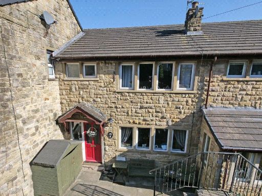 3 bedroom house for sale in 4 Cross Hills Road, Cononley, Keighley, West Yorkshire, BD20 8LA, BD20 — £299,000 • 3 bed • 1 bath • 613 ft²
 2 bedroom town house for sale in 49 Meadow Lane, Cononley BD20 8NB, BD20 — £275,000 • 2 bed • 1 bath • 726 ft²
 3 bedroom cottage for sale in 13 Crag View, Cononley BD20 8JU, BD20 — £240,000 • 3 bed • 1 bath • 714 ft²
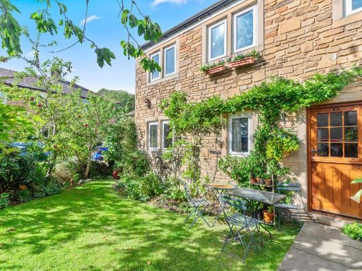 3 bedroom semi-detached house for sale in Meadow Lane, Cononley, Keighley, North Yorkshire, BD20 — £319,950 • 3 bed • 1 bath • 976 ft²
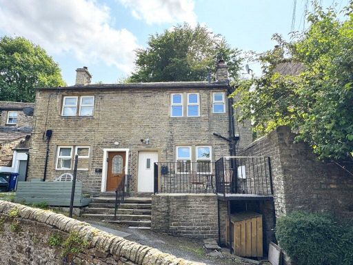 2 bedroom semi-detached house for sale in 91 Main Street, Cononley, BD20 8LJ, BD20 — £227,000 • 2 bed • 1 bath • 536 ft²
Meta
- {
"@context": "https://schema.org",
"@type": "Residence",
"name": "3 bedroom terraced house for sale in Aireside, Cononley, BD…",
"description": "",
"url": "https://propertypiper.co.uk/property/7e42346e-dbf9-4137-9c20-8882eafcdd53",
"image": "https://image-a.propertypiper.co.uk/e9795645-e49c-4367-982e-2501cae83331-1024.jpeg",
"address": {
"@type": "PostalAddress",
"streetAddress": "7 AIRESIDE CONONLEY KEIGHLEY",
"postalCode": "BD20 8LT",
"addressLocality": "Craven",
"addressRegion": "Skipton and Ripon",
"addressCountry": "England"
},
"geo": {
"@type": "GeoCoordinates",
"latitude": 53.917137547866915,
"longitude": -2.006632212383665
},
"numberOfRooms": 3,
"numberOfBathroomsTotal": 2,
"floorSize": {
"@type": "QuantitativeValue",
"value": 1006,
"unitCode": "FTK"
},
"offers": {
"@type": "Offer",
"price": 240000,
"priceCurrency": "GBP",
"availability": "https://schema.org/InStock"
},
"additionalProperty": [
{
"@type": "PropertyValue",
"name": "Feature",
"value": "Victorian"
},
{
"@type": "PropertyValue",
"name": "Feature",
"value": "terraced"
},
{
"@type": "PropertyValue",
"name": "Feature",
"value": "period property"
},
{
"@type": "PropertyValue",
"name": "Feature",
"value": "stone"
},
{
"@type": "PropertyValue",
"name": "Feature",
"value": "historic"
},
{
"@type": "PropertyValue",
"name": "Feature",
"value": "three stories"
},
{
"@type": "PropertyValue",
"name": "Feature",
"value": "front garden"
},
{
"@type": "PropertyValue",
"name": "Feature",
"value": "no garage"
},
{
"@type": "PropertyValue",
"name": "Feature",
"value": "traditional style"
},
{
"@type": "PropertyValue",
"name": "Feature",
"value": "period features"
},
{
"@type": "PropertyValue",
"name": "Feature",
"value": "rural"
},
{
"@type": "PropertyValue",
"name": "Feature",
"value": "landscape"
},
{
"@type": "PropertyValue",
"name": "Feature",
"value": "countryside"
},
{
"@type": "PropertyValue",
"name": "Feature",
"value": "pasture"
},
{
"@type": "PropertyValue",
"name": "Feature",
"value": "nature"
},
{
"@type": "PropertyValue",
"name": "Feature",
"value": "scenic"
},
{
"@type": "PropertyValue",
"name": "Feature",
"value": "quiet"
},
{
"@type": "PropertyValue",
"name": "Feature",
"value": "views"
}
]
}
High Res Floorplan Images
Compatible Floorplan Images
FloorplanImages Thumbnail