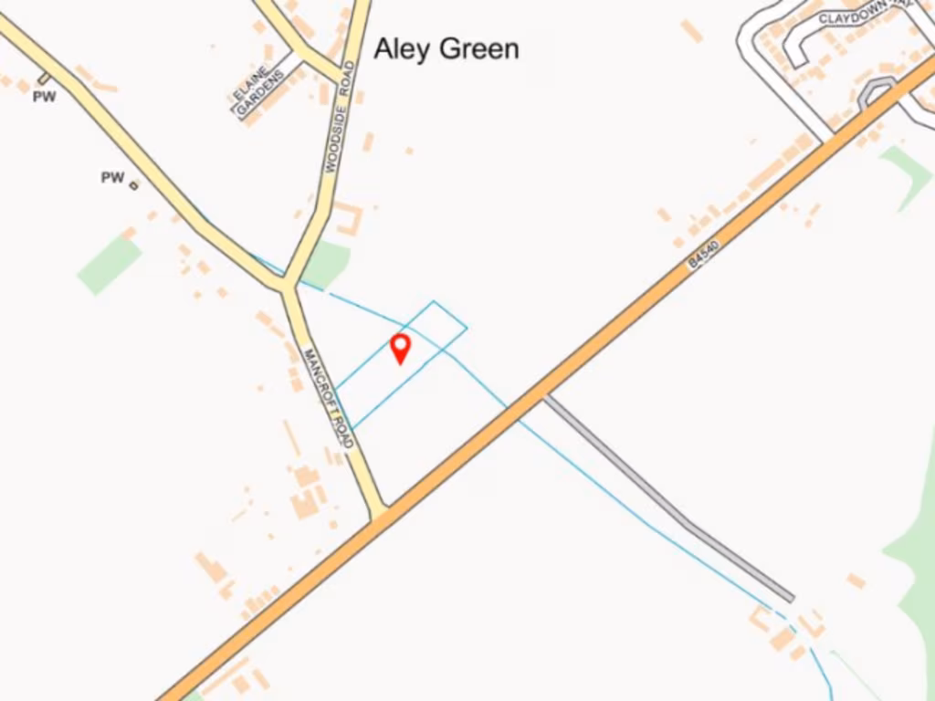
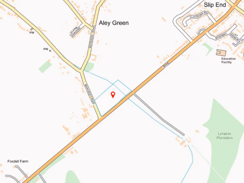
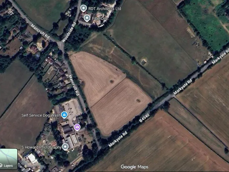
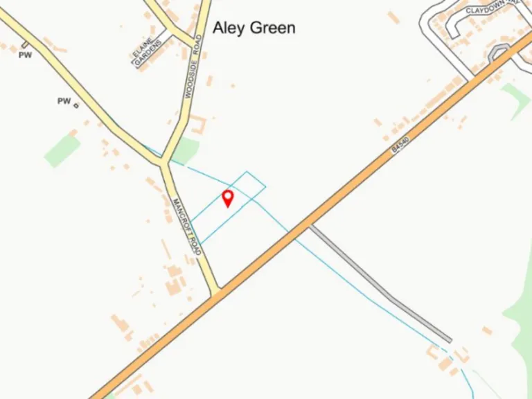
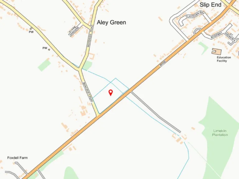
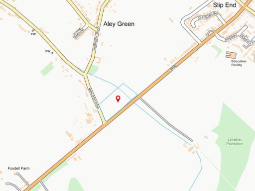
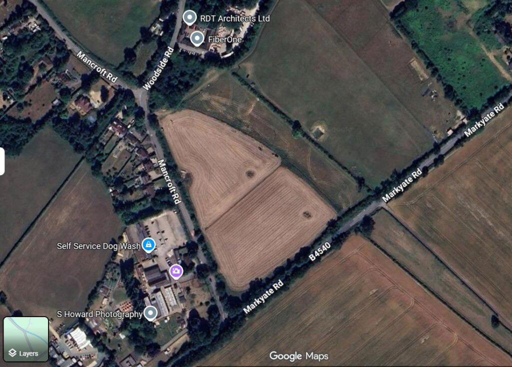
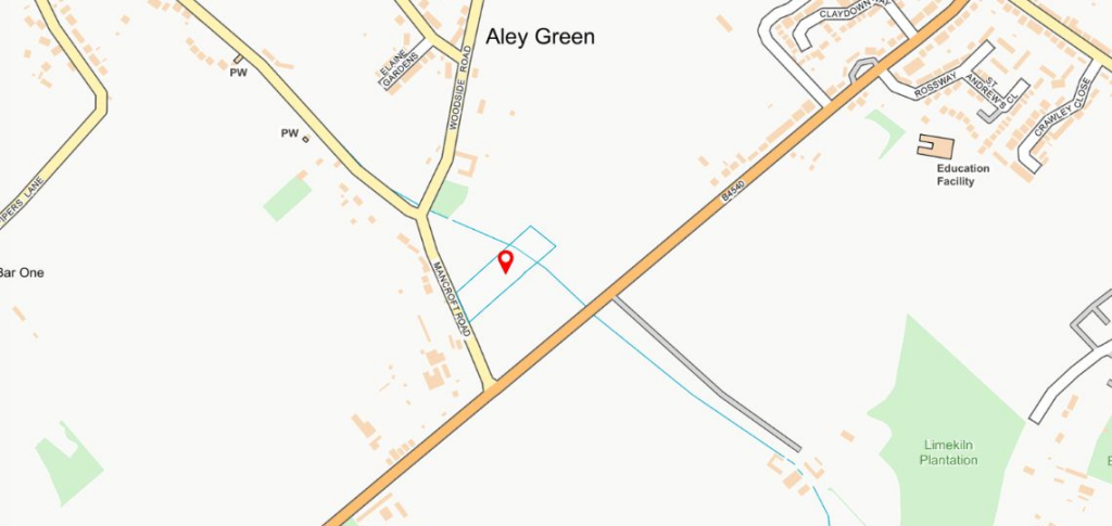
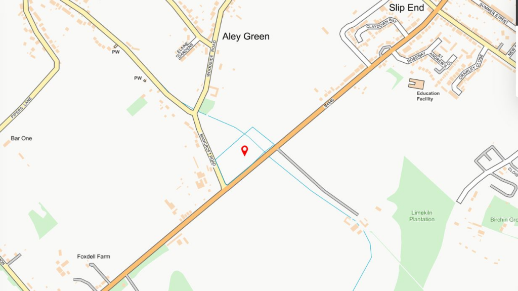
LU1 4DG - Land for sale in Slip End Road, Luton, Bedfordshire, LU1 4D…
View on Property Piper
Land for sale in Slip End Road, Luton, Bedfordshire, LU1 4DG , LU1
Property Details
- Price: £425000
- Bedrooms: 1
- Bathrooms: 1
- Property Type: undefined
- Property SubType: undefined
Image Descriptions
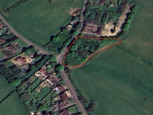
- land agricultural
- land plot
Textual Property Features
Detected Visual Features
- field
- agricultural
- land
- development opportunity
- rural
- open space
- potential
- expansion
- investment
- plot
- Aley Green
- development potential
- vacant land
- residential
Nearby Schools
- Oakwood Primary School
- Tennyson Road Primary School
- St Margaret of Scotland Catholic Primary School
- Whipperley Infant Academy
- Foxdell Primary School
- Maidenhall Primary School
- Caddington Village School
- The Linden Academy
- Hillborough Junior School
- Mehria Primary School
- Denbigh Primary School
- Beechwood Park School
- Kensworth Church of England Academy
- Slip End Village School
- Surrey Street Primary School
- Farley Junior Academy
- Hillborough Infant and Nursery School
- Dallow Primary School
- Bury Park Educational Institute (Al - Hikmah Secondary School)
- Downside Primary School
- Denbigh High School
- Jamiatul Uloom Al - Islamia
- Flamstead Village School
- Markyate Village School and Nursery
- The Stockwood Park Academy
- Beech Hill Community Primary School
- Challney High School for Boys
Nearest General Shops
- Id: 203425069
- Tags:
- Addr:
- City: Pepperstock
- Country: GB
- Postcode: LU1 4LL
- Street: Halfmoon Lane
- Fhrs:
- Authority: Central Bedfordshire
- Id: 736025
- Local_authority_id: 154031
- Name: Harpers
- Shop: butcher
- TagsNormalized:
- Lat: 51.8506362
- Lon: -0.4254907
- FullGeoHash: gcpwyr45v75h
- PartitionGeoHash: gcpw
- Images:
- FoodStandards: null
- Distance: 1460.8
,- Id: 699084071
- Tags:
- Brand: Citroën
- Brand:wikidata: Q6746
- Brand:wikipedia: fr:Citroën
- Building: yes
- Name: Citroën
- Shop: car
- TagsNormalized:
- Lat: 51.8533545
- Lon: -0.4352541
- FullGeoHash: gcpwype59vgh
- PartitionGeoHash: gcpw
- Images:
- FoodStandards: null
- Distance: 855.3
,- Id: 699084072
- Tags:
- Brand: Citroën
- Brand:wikidata: Q6746
- Brand:wikipedia: fr:Citroën
- Building: yes
- Name: Citroën
- Shop: car_repair
- TagsNormalized:
- citroën
- car repair
- repair
- shop
- Lat: 51.8547287
- Lon: -0.4365443
- FullGeoHash: gcpwypf5ey0c
- PartitionGeoHash: gcpw
- Images:
- FoodStandards: null
- Distance: 850.3
}
Nearest Grocery shops
- Id: 6679715327
- Tags:
- Addr:
- City: Luton
- Country: GB
- Housenumber: 13
- Postcode: LU1 4EE
- Street: Manor Road
- Village: Caddington
- Amenity: fast_food
- Fhrs:
- Authority: Central Bedfordshire
- Id: 450591
- Local_authority_id: 65534
- Name: Sky Fry Fish & Chip Shop
- TagsNormalized:
- fast food
- food
- chip
- fish
- shop
- Lat: 51.8655177
- Lon: -0.4573917
- FullGeoHash: gcpxj9ffw120
- PartitionGeoHash: gcpx
- Images:
- FoodStandards: null
- Distance: 1832.3
,- Id: 249389067
- Tags:
- Addr:
- City: Luton
- Country: GB
- Housenumber: 43
- Postcode: LU1 4HS
- Street: Elm Avenue
- Village: Caddington
- Fhrs:
- Authority: Central Bedfordshire
- Id: 1127024
- Local_authority_id: 168972
- Name: A & A Convenience Store
- Shop: convenience
- TagsNormalized:
- Lat: 51.8625227
- Lon: -0.4549878
- FullGeoHash: gcpxj9k9n4bw
- PartitionGeoHash: gcpx
- Images:
- FoodStandards: null
- Distance: 1461.2
,- Id: 249451061
- Tags:
- Addr:
- City: Luton
- Country: GB
- Housenumber: 1
- Postcode: LU1 4BU
- Street: Markyate Road
- Village: Slip End
- Fhrs:
- Authority: Central Bedfordshire
- Id: 450592
- Local_authority_id: 65601
- Name: Slip End Superstore
- Shop: convenience
- TagsNormalized:
- Lat: 51.8544337
- Lon: -0.4335521
- FullGeoHash: gcpwypu3cx01
- PartitionGeoHash: gcpw
- Images:
- FoodStandards:
- Id: 450592
- FHRSID: 450592
- LocalAuthorityBusinessID: 65601
- BusinessName: Slip End Superstore
- BusinessType: Retailers - other
- BusinessTypeID: 4613
- AddressLine1: 1 Markyate Road
- AddressLine2: Slip End
- AddressLine3: Bedfordshire
- AddressLine4: null
- PostCode: LU1 4BU
- RatingValue: 4
- RatingKey: fhrs_4_en-GB
- RatingDate: 2021-11-24
- LocalAuthorityCode: 702
- LocalAuthorityName: Central Bedfordshire
- LocalAuthorityWebSite: http://www.centralbedfordshire.gov.uk
- LocalAuthorityEmailAddress: env.health@centralbedfordshire.gov.uk
- Scores:
- Hygiene: 5
- Structural: 10
- ConfidenceInManagement: 0
- NewRatingPending: false
- Geocode:
- Longitude: -0.43507400000000
- Latitude: 51.85350600000000
- Distance: 1011.4
}
Nearest Religious buildings
- Id: 787889963
- Tags:
- Amenity: place_of_worship
- Building: church
- Denomination: anglican
- Name: St Andrew
- Religion: christian
- Wikidata: Q26408445
- TagsNormalized:
- place of worship
- church
- anglican
- christian
- Lat: 51.8576395
- Lon: -0.430684
- FullGeoHash: gcpxn0qkskdt
- PartitionGeoHash: gcpx
- Images:
- FoodStandards: null
- Distance: 1365.8
,- Id: 1009960794
- Tags:
- Addr:
- City: Caddington
- Housename: St Thomas Church
- Postcode: LU1 4HH
- Street: Manor Road
- Amenity: place_of_worship
- Building: yes
- Denomination: catholic
- Name: St Thomas the Apostle Catholic Church
- Religion: christian
- TagsNormalized:
- place of worship
- catholic
- church
- christian
- Lat: 51.8596165
- Lon: -0.4545742
- FullGeoHash: gcpxj8ubpthy
- PartitionGeoHash: gcpx
- Images:
- FoodStandards: null
- Distance: 1156.5
,- Id: 249444026
- Tags:
- Amenity: place_of_worship
- Denomination: methodist
- Name: Aley Green Methodist Church
- Religion: christian
- TagsNormalized:
- place of worship
- methodist
- church
- christian
- Lat: 51.8536602
- Lon: -0.4509167
- FullGeoHash: gcpwvxxtkyu5
- PartitionGeoHash: gcpw
- Images:
- FoodStandards: null
- Distance: 461.2
}
Nearest Medical buildings
- Id: 7188946424
- Tags:
- Amenity: doctors
- Healthcare: doctor
- Name: Farley Hill Medical Centre
- TagsNormalized:
- doctor
- doctors
- health
- healthcare
- Lat: 51.8750735
- Lon: -0.4387611
- FullGeoHash: gcpxn58d0ns4
- PartitionGeoHash: gcpx
- Images:
- FoodStandards: null
- Distance: 2797.3
,- Id: 7188946426
- Tags:
- Amenity: pharmacy
- Healthcare: pharmacy
- Name: Farley Hill Pharmacy
- TagsNormalized:
- Lat: 51.8750023
- Lon: -0.4386297
- FullGeoHash: gcpxn589g1mf
- PartitionGeoHash: gcpx
- Images:
- FoodStandards: null
- Distance: 2791.4
,- Id: 255593745
- Tags:
- Addr:
- City: St Albans
- Housenumber: 40
- Postcode: AL3 8PB
- Street: High Street
- Village: Markyate
- Amenity: pharmacy
- Fhrs:
- Name: Markyate Pharmacy
- Source:
- Addr: FHRS Open Data
- Name: FHRS Open Data
- TagsNormalized:
- Lat: 51.8371151
- Lon: -0.4618234
- FullGeoHash: gcpwvkxtndxs
- PartitionGeoHash: gcpw
- Images:
- FoodStandards:
- Id: 734521
- FHRSID: 734521
- LocalAuthorityBusinessID: 1009
- BusinessName: Markyate Pharmacy
- BusinessType: Retailers - other
- BusinessTypeID: 4613
- AddressLine1: null
- AddressLine2: 40 High Street
- AddressLine3: Markyate
- AddressLine4: St. Albans, Herts
- PostCode: AL3 8PB
- RatingValue: Exempt
- RatingKey: fhrs_exempt_en-GB
- RatingDate: 2021-04-26
- LocalAuthorityCode: 156
- LocalAuthorityName: Dacorum
- LocalAuthorityWebSite: http://www.dacorum.gov.uk
- LocalAuthorityEmailAddress: ecp@dacorum.gov.uk
- Scores:
- Hygiene: null
- Structural: null
- ConfidenceInManagement: null
- NewRatingPending: false
- Geocode:
- Longitude: -0.46247900000000
- Latitude: 51.83757400000000
- Distance: 1804.3
,- Id: 247419194
- Tags:
- Addr:
- City: Caddington
- Country: GB
- Housenumber: 31
- Postcode: LU1 4EE
- Street: Manor Road
- Amenity: pharmacy
- Fhrs:
- Authority: Central Bedfordshire
- Id: 564665
- Local_authority_id: 13313
- Name: Medigreen Pharmacy
- TagsNormalized:
- Lat: 51.864825
- Lon: -0.4581287
- FullGeoHash: gcpxj9dqsb4k
- PartitionGeoHash: gcpx
- Images:
- FoodStandards: null
- Distance: 1783.5
}
Nearest Airports
- Id: 110273499
- Tags:
- Addr:
- Country: GB
- Postcode: LU2 9LY
- Aerodrome: international
- Aerodrome:type: public
- Aeroway: aerodrome
- Alt_name: London Luton
- Iata: LTN
- Icao: EGGW
- Name: London Luton Airport
- Website: https://www.london-luton.co.uk/
- Wikidata: Q8712
- Wikipedia: en:Luton Airport
- TagsNormalized:
- airport
- international airport
- Lat: 51.8780363
- Lon: -0.3701408
- FullGeoHash: gcpxps47rngh
- PartitionGeoHash: gcpx
- Images:
- FoodStandards: null
- Distance: 6092.3
}
Nearest Tourist attractions
- Id: 6293013786
- Tags:
- Name: Whitney’s Apartment
- Tourism: apartment
- TagsNormalized:
- Lat: 51.8763096
- Lon: -0.4083276
- FullGeoHash: gcpxney9mm0b
- PartitionGeoHash: gcpx
- Images:
- FoodStandards: null
- Distance: 3906.3
,- Id: 802670897
- Tags:
- Addr:
- City: Luton
- Housename: Stockwood Park Golf Club
- Postcode: LU1 4LX
- Street: London Road
- Fee: no
- Museum: local_history
- Name: Stockwood Discovery Centre
- Opening_hours: We-Su 11:00-17:00
- Operator: Culture Trust
- Tourism: museum
- Website: https://www.culturetrust.com/venues/stockwood-discovery-centre
- Wheelchair: yes
- TagsNormalized:
- Lat: 51.865932
- Lon: -0.4228416
- FullGeoHash: gcpxn3uhgn6r
- PartitionGeoHash: gcpx
- Images:
- FoodStandards: null
- Distance: 2382.8
,- Id: 429382833
- Tags:
- TagsNormalized:
- Lat: 51.8651477
- Lon: -0.4261006
- FullGeoHash: gcpxn3c8rhk3
- PartitionGeoHash: gcpx
- Images:
- FoodStandards: null
- Distance: 2167.8
}
Nearest Train stations
- Id: 6825844805
- Tags:
- Name: Harpenden
- Naptan:
- Network: gb-national-rail
- Public_transport: station
- Railway: station
- Ref:
- Source: NPE
- Train: yes
- Wheelchair: yes
- Wheelchair:description: Lifts from platform to footbridge. Step-free exit from platform 1 to car park on east side.
- Wikidata: Q2278802
- Wikipedia: en:Harpenden railway station
- TagsNormalized:
- Lat: 51.8148177
- Lon: -0.3515572
- FullGeoHash: gcpyb0850n5g
- PartitionGeoHash: gcpy
- Images:
- FoodStandards: null
- Distance: 7645.2
,- Id: 9725567363
- Tags:
- Name: Whipsnade Central
- Public_transport: station
- Railway: station
- Train: yes
- Usage: tourism
- TagsNormalized:
- Lat: 51.8461109
- Lon: -0.5415762
- FullGeoHash: gcpwgwm9kred
- PartitionGeoHash: gcpw
- Images:
- FoodStandards: null
- Distance: 6530.8
,- Id: 21285573
- Tags:
- Name: Leagrave
- Naptan:
- Network: National Rail
- Public_transport: station
- Railway: station
- Ref:
- Wheelchair: no
- Wikidata: Q12061118
- Wikipedia: en:Leagrave railway station
- TagsNormalized:
- Lat: 51.9054737
- Lon: -0.4585987
- FullGeoHash: gcpxm9453cs5
- PartitionGeoHash: gcpx
- Images:
- FoodStandards: null
- Distance: 6177
,- Id: 6750291608
- Tags:
- Name: Luton Airport Parkway
- Naptan:
- Network: National Rail
- Public_transport: station
- Railway: station
- Ref:
- Train: yes
- Wheelchair: yes
- Wheelchair:description: Lifts from booking office to footbridge with lifts to all platforms. Step-free exit from platform 1 to Kimpton Road. Step-free from main entrance to shuttle bus to Airport. Toilets not checked on this visit. 10 blue badge spaces.
- Wikidata: Q801135
- Wikipedia: en:Luton Airport Parkway railway station
- TagsNormalized:
- Lat: 51.872845
- Lon: -0.3961244
- FullGeoHash: gcpxngpt1xhj
- PartitionGeoHash: gcpx
- Images:
- FoodStandards: null
- Distance: 4279.5
,- Id: 8399259717
- Tags:
- Name: Luton
- Naptan:
- Network: National Rail
- Public_transport: station
- Railway: station
- Ref:
- Wikidata: Q1809595
- Wikipedia: en:Luton railway station
- TagsNormalized:
- Lat: 51.8825271
- Lon: -0.4140848
- FullGeoHash: gcpxnsfmxh5c
- PartitionGeoHash: gcpx
- Images:
- FoodStandards: null
- Distance: 4217.8
}
Nearest Bus stations and stops
- Id: 249443975
- Tags:
- Bus: yes
- Highway: bus_stop
- Public_transport: platform
- TagsNormalized:
- Lat: 51.8537972
- Lon: -0.4506362
- FullGeoHash: gcpwvxxy72mk
- PartitionGeoHash: gcpw
- Images:
- FoodStandards: null
- Distance: 461.8
,- Id: 249453575
- Tags:
- Bus: yes
- Highway: bus_stop
- Public_transport: platform
- TagsNormalized:
- Lat: 51.8538781
- Lon: -0.445604
- FullGeoHash: gcpwvzew8xmx
- PartitionGeoHash: gcpw
- Images:
- FoodStandards: null
- Distance: 394.2
,- Id: 249453604
- Tags:
- Bus: yes
- Highway: bus_stop
- Public_transport: platform
- TagsNormalized:
- Lat: 51.8538615
- Lon: -0.4454905
- FullGeoHash: gcpwvzewek6h
- PartitionGeoHash: gcpw
- Images:
- FoodStandards: null
- Distance: 394
,- Id: 249443943
- Tags:
- Bus: yes
- Highway: bus_stop
- Public_transport: platform
- TagsNormalized:
- Lat: 51.8516342
- Lon: -0.4473746
- FullGeoHash: gcpwvz61xmjq
- PartitionGeoHash: gcpw
- Images:
- FoodStandards: null
- Distance: 143.1
,- Id: 417225449
- Tags:
- Bus: yes
- Highway: bus_stop
- Public_transport: platform
- TagsNormalized:
- Lat: 51.8514273
- Lon: -0.4466903
- FullGeoHash: gcpwvz68rqee
- PartitionGeoHash: gcpw
- Images:
- FoodStandards: null
- Distance: 113.7
}
Nearest Hotels
- Id: 749288533
- Tags:
- Addr:
- City: Luton
- Housenumber: 136
- Postcode: LU1 3RP
- Street: Tennyson Road
- Building: hotel
- Email: bookings@lintonhotel.com
- Fhrs:
- Authority: Luton
- Id: 1027689
- Local_authority_id: 15995
- Name: Linton Luton Hotel
- Phone: +44 1582 407644
- Tourism: hotel
- Website: http://www.lintonhotel.com
- TagsNormalized:
- Lat: 51.8674185
- Lon: -0.4173938
- FullGeoHash: gcpxnd0jd58e
- PartitionGeoHash: gcpx
- Images:
- FoodStandards: null
- Distance: 2764.9
,- Id: 1009912737
- Tags:
- Brand: Premier Inn
- Brand:wikidata: Q2108626
- Brand:wikipedia: en:Premier Inn
- Building: yes
- Internet_access: wlan
- Internet_access:fee: customers
- Internet_access:operator: Virgin Media
- Internet_access:ssid: Premier Inn Free Wi-Fi
- Name: Premier Inn
- Tourism: hotel
- TagsNormalized:
- Lat: 51.8571403
- Lon: -0.4798419
- FullGeoHash: gcpxj069dzeg
- PartitionGeoHash: gcpx
- Images:
- FoodStandards: null
- Distance: 2392.7
,- Id: 294878882
- Tags:
- Addr:
- City: St Albans
- Postcode: AL3 8HH
- Street: London Road
- Village: Markyate
- Brand: Holiday Inn
- Brand:wikidata: Q2717882
- Brand:wikipedia: en:Holiday Inn
- Fhrs:
- Name: Holiday Inn
- Source:
- Tourism: hotel
- TagsNormalized:
- Lat: 51.8290226
- Lon: -0.4443934
- FullGeoHash: gcpwvghmuyh6
- PartitionGeoHash: gcpw
- Images:
- FoodStandards: null
- Distance: 2383.2
}
Tags
- field
- agricultural
- land
- development opportunity
- rural
- open space
- potential
- expansion
- investment
- land
- plot
- Aley Green
- investment
- development potential
- vacant land
- residential
Local Market Stats
- Average Price/sqft: £314
- Avg Income: £42600
- Rental Yield: 4.7%
- Social Housing: 13%
- Planning Success Rate: 71%
Similar Properties
 Land for sale in Mancroft Road, Luton, Bedfordshire, LU1 — £200,000 • 1 bed • 1 bath
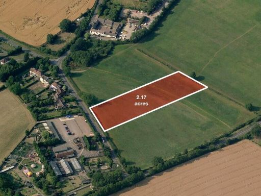 Land for sale in 2.17 acres on a residential road in Slip End, Bedfordshire / Hertfordshire, LU1 — £145,000 • 1 bed • 1 bath
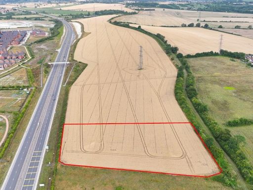 Land for sale in Luton Road, Chalton, LU4 — £75,000 • 1 bed • 1 bath
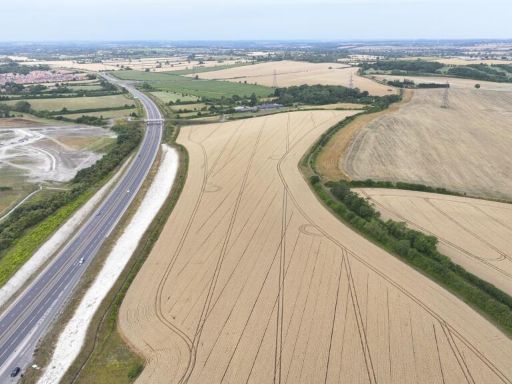 Land for sale in Luton Road, Chalton, LU4 — £250,000 • 1 bed • 1 bath
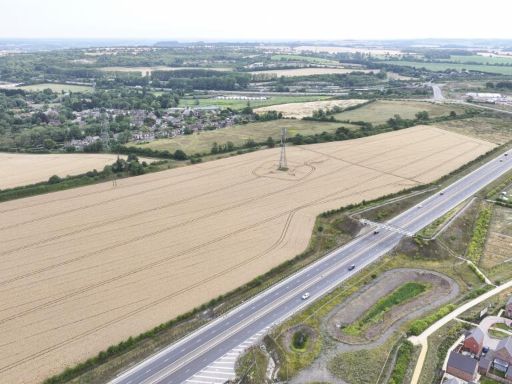 Land for sale in Luton Road, Chalton, LU4 — £850,000 • 1 bed • 1 bath
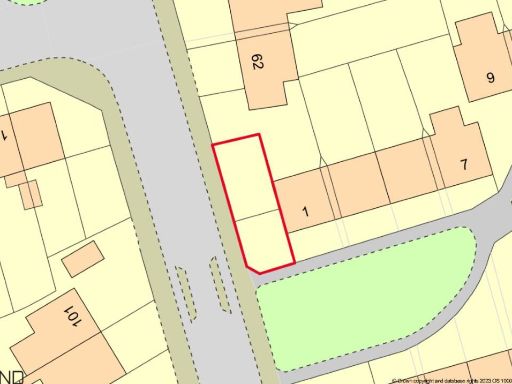 Land for sale in Land Adjacent to 1 The Link, Houghton Regis, Dunstable, Bedfordshire, LU5 5HQ, LU5 — £10,000 • 1 bed • 1 bath • 1087 ft²
Meta
- {
"@context": "https://schema.org",
"@type": "Residence",
"name": "Land for sale in Slip End Road, Luton, Bedfordshire, LU1 4D…",
"description": "",
"url": "https://propertypiper.co.uk/property/74b635e9-4e73-4f3f-b2ca-6cd19aa1a7cb",
"image": "https://image-a.propertypiper.co.uk/479a1bb8-12be-477b-b31d-14db6e161ff9-1024.jpeg",
"address": {
"@type": "PostalAddress",
"streetAddress": "Slip End Road, Luton, Bedfordshire, LU1 4DG ",
"postalCode": "LU1 4DG",
"addressLocality": "Central Bedfordshire",
"addressRegion": "Luton South",
"addressCountry": "England"
},
"geo": {
"@type": "GeoCoordinates",
"latitude": 51.850405472536806,
"longitude": -0.4467551400339801
},
"numberOfRooms": 1,
"numberOfBathroomsTotal": 1,
"offers": {
"@type": "Offer",
"price": 425000,
"priceCurrency": "GBP",
"availability": "https://schema.org/InStock"
},
"additionalProperty": [
{
"@type": "PropertyValue",
"name": "Feature",
"value": "field"
},
{
"@type": "PropertyValue",
"name": "Feature",
"value": "agricultural"
},
{
"@type": "PropertyValue",
"name": "Feature",
"value": "land"
},
{
"@type": "PropertyValue",
"name": "Feature",
"value": "development opportunity"
},
{
"@type": "PropertyValue",
"name": "Feature",
"value": "rural"
},
{
"@type": "PropertyValue",
"name": "Feature",
"value": "open space"
},
{
"@type": "PropertyValue",
"name": "Feature",
"value": "potential"
},
{
"@type": "PropertyValue",
"name": "Feature",
"value": "expansion"
},
{
"@type": "PropertyValue",
"name": "Feature",
"value": "investment"
},
{
"@type": "PropertyValue",
"name": "Feature",
"value": "land"
},
{
"@type": "PropertyValue",
"name": "Feature",
"value": "plot"
},
{
"@type": "PropertyValue",
"name": "Feature",
"value": "Aley Green"
},
{
"@type": "PropertyValue",
"name": "Feature",
"value": "investment"
},
{
"@type": "PropertyValue",
"name": "Feature",
"value": "development potential"
},
{
"@type": "PropertyValue",
"name": "Feature",
"value": "vacant land"
},
{
"@type": "PropertyValue",
"name": "Feature",
"value": "residential"
}
]
}