BN21 4JF - 3 bedroom flat for sale in Blackwater Road, Eastbourne, BN21
View on Property Piper
3 bedroom flat for sale in Blackwater Road, Eastbourne, BN21
Property Details
- Price: £259950
- Bedrooms: 3
- Bathrooms: 1
- Property Type: undefined
- Property SubType: undefined
Brochure Descriptions
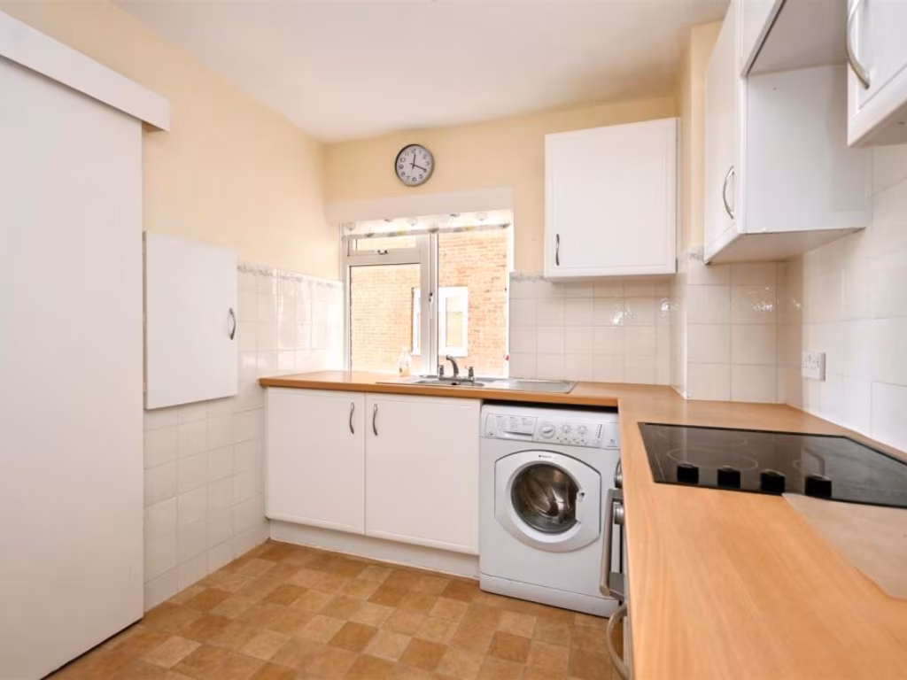
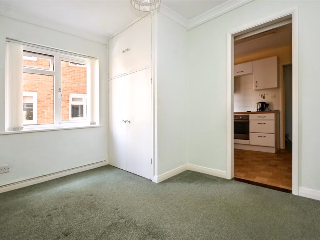
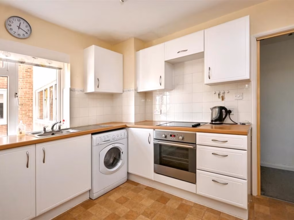
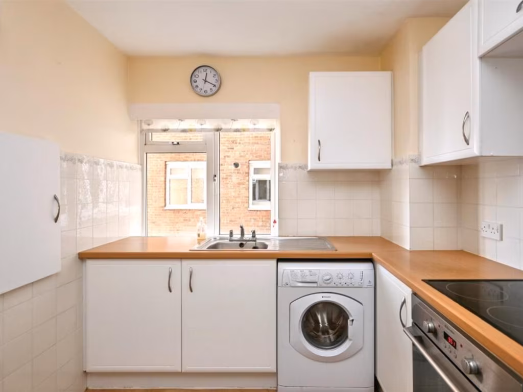
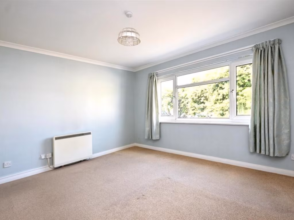
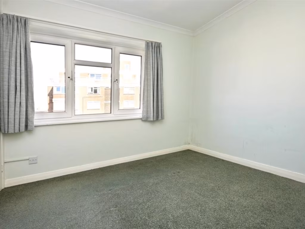
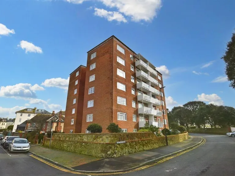
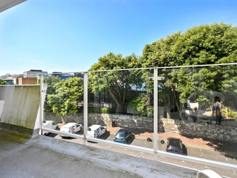
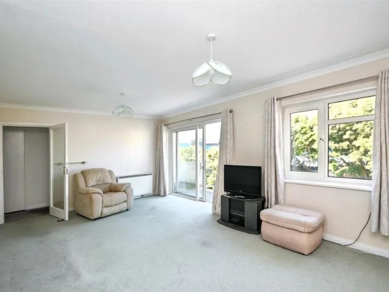
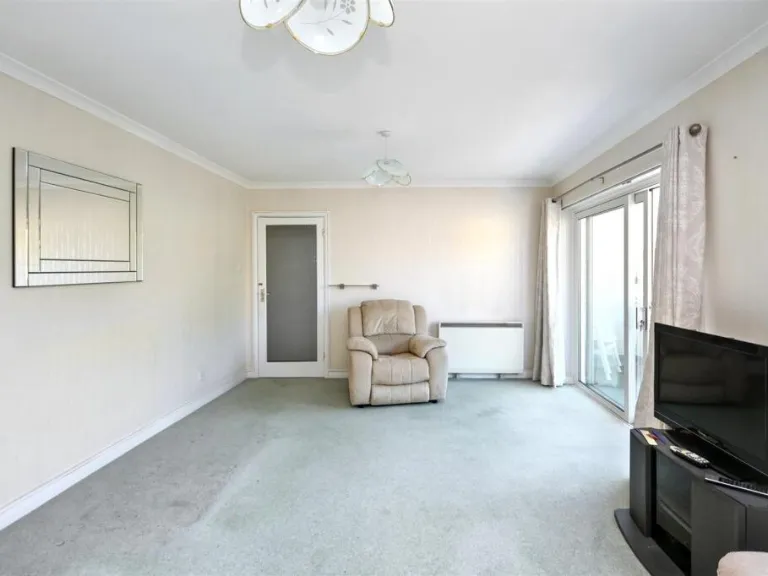
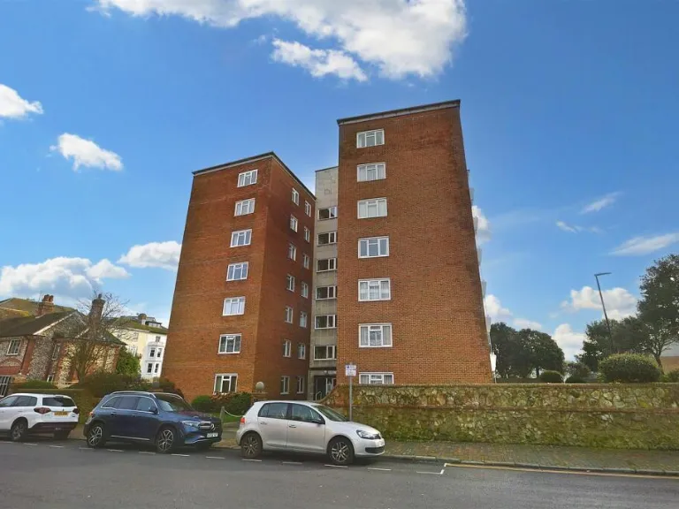
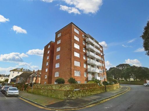
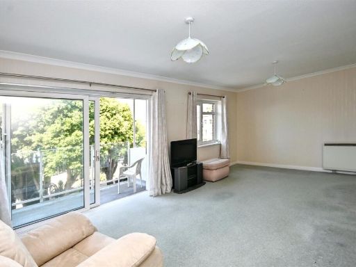
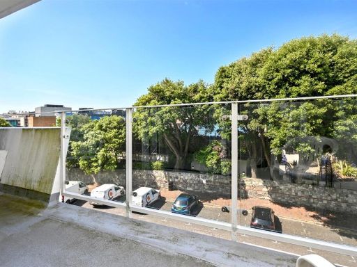
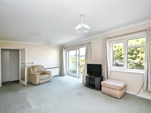
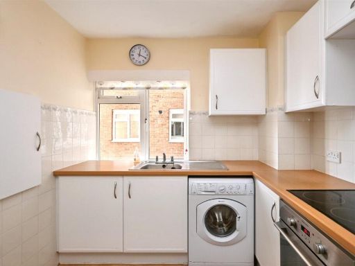
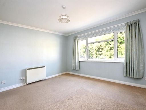
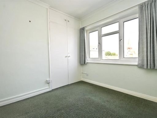
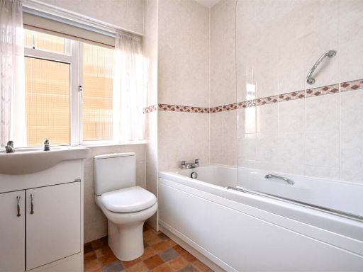
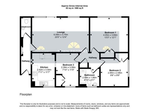
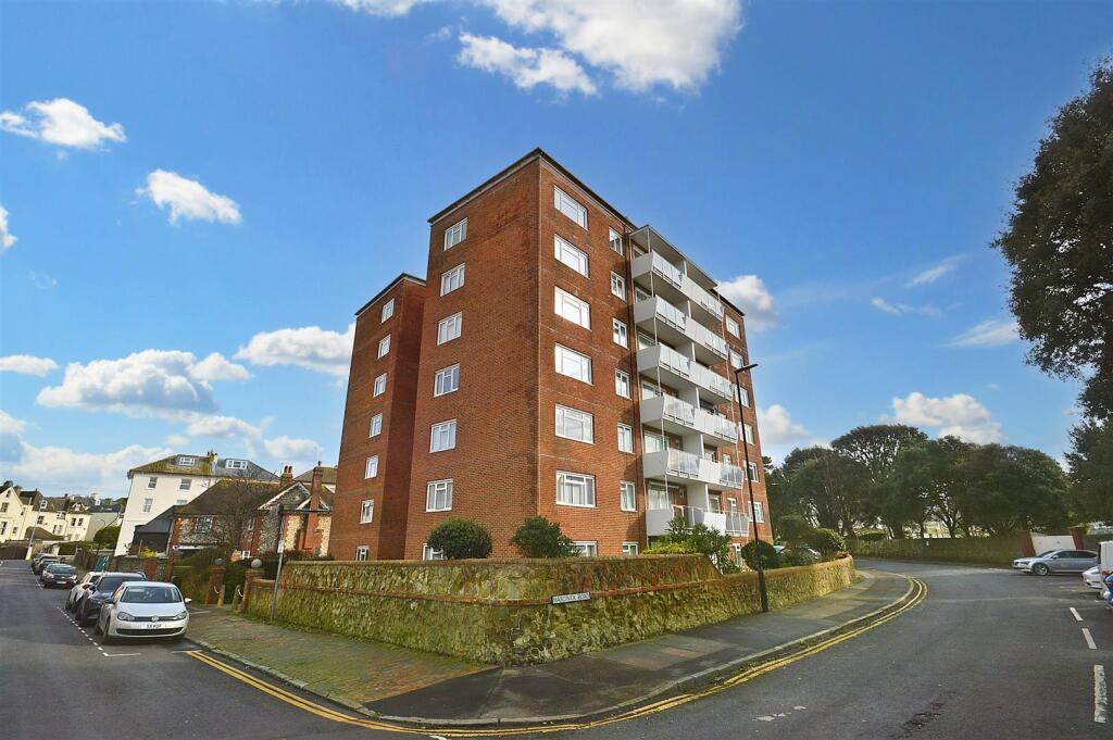
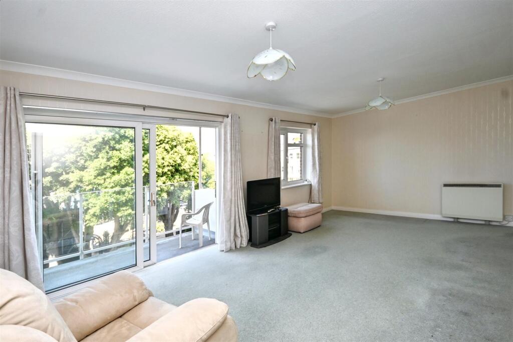
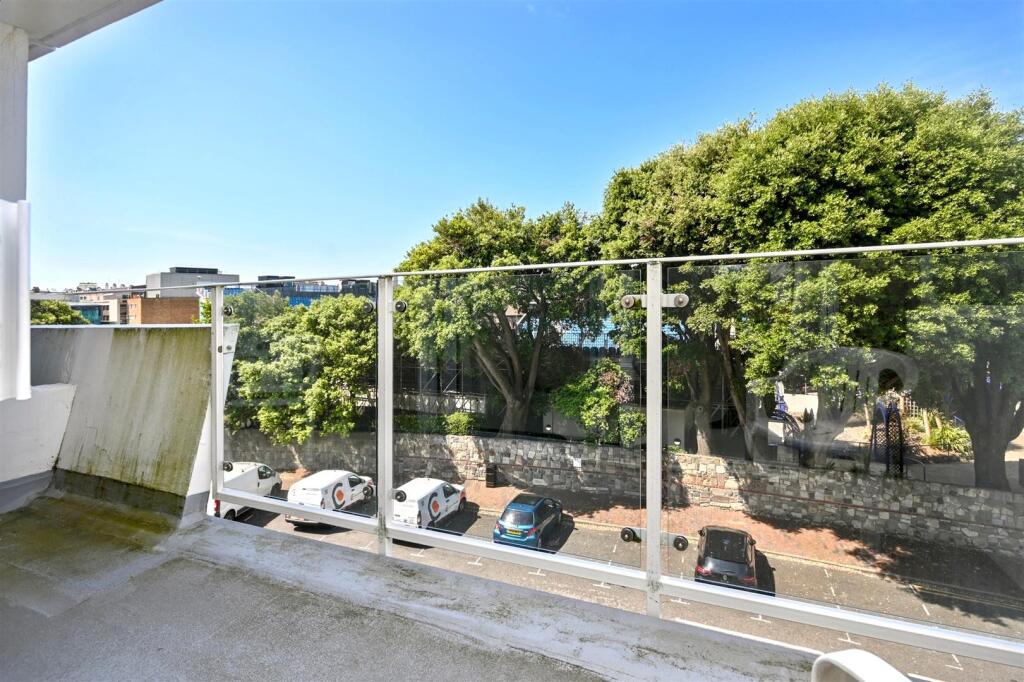
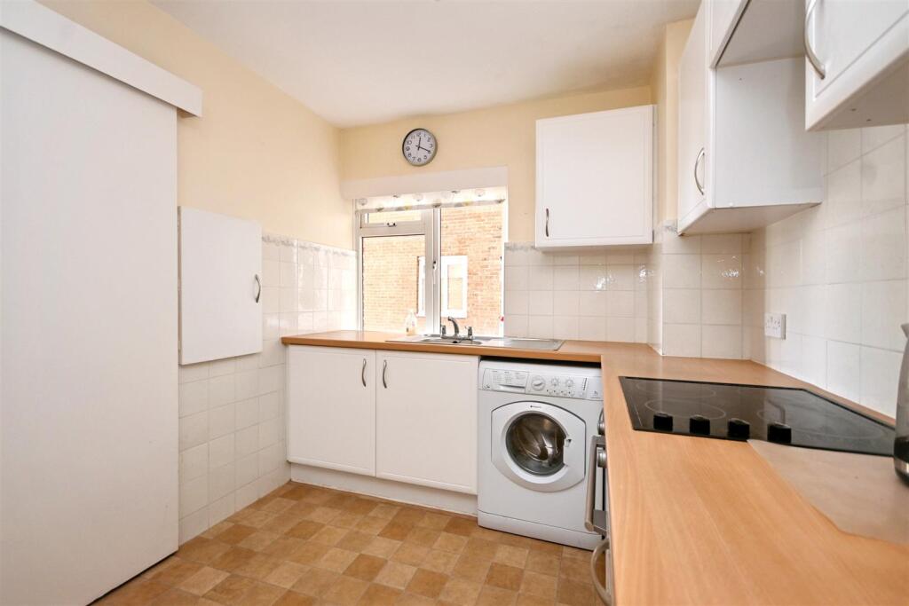
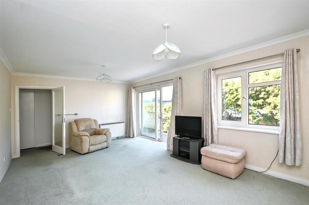
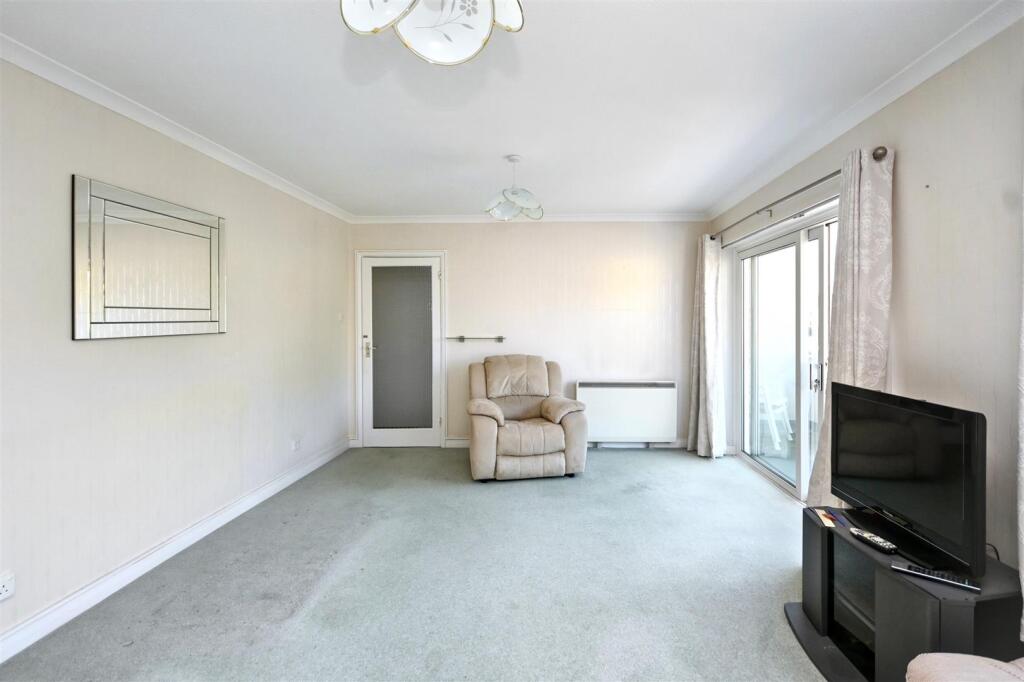
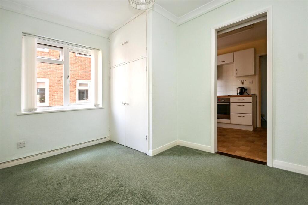
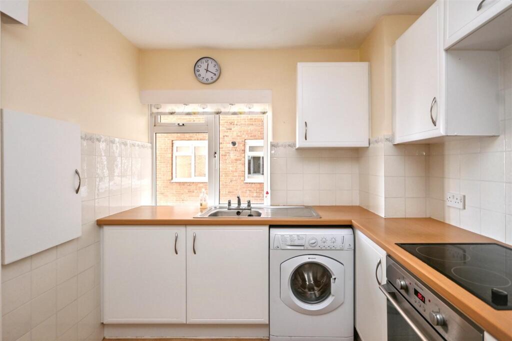
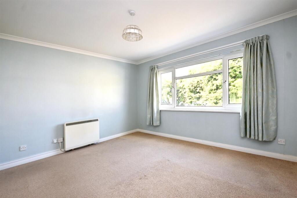
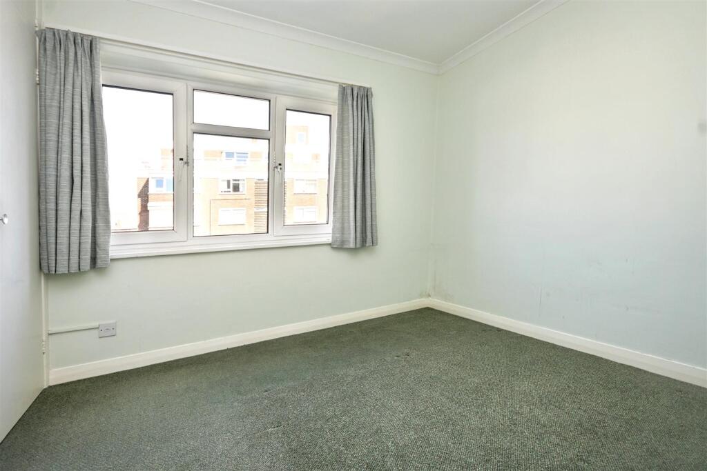
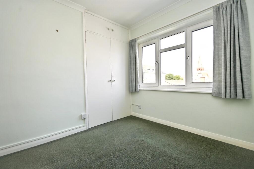
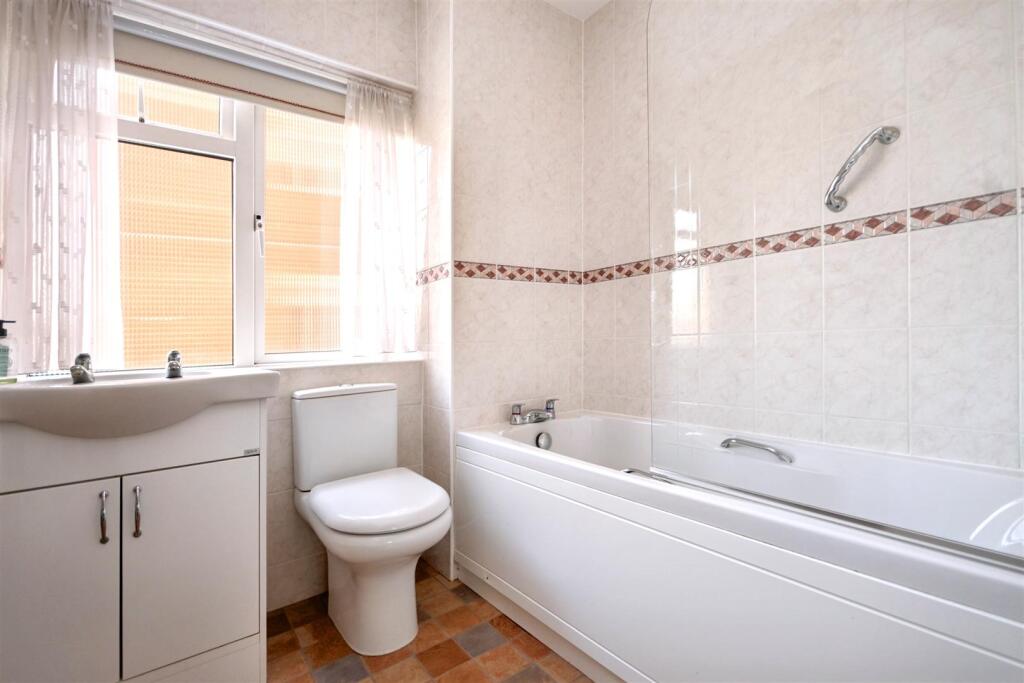
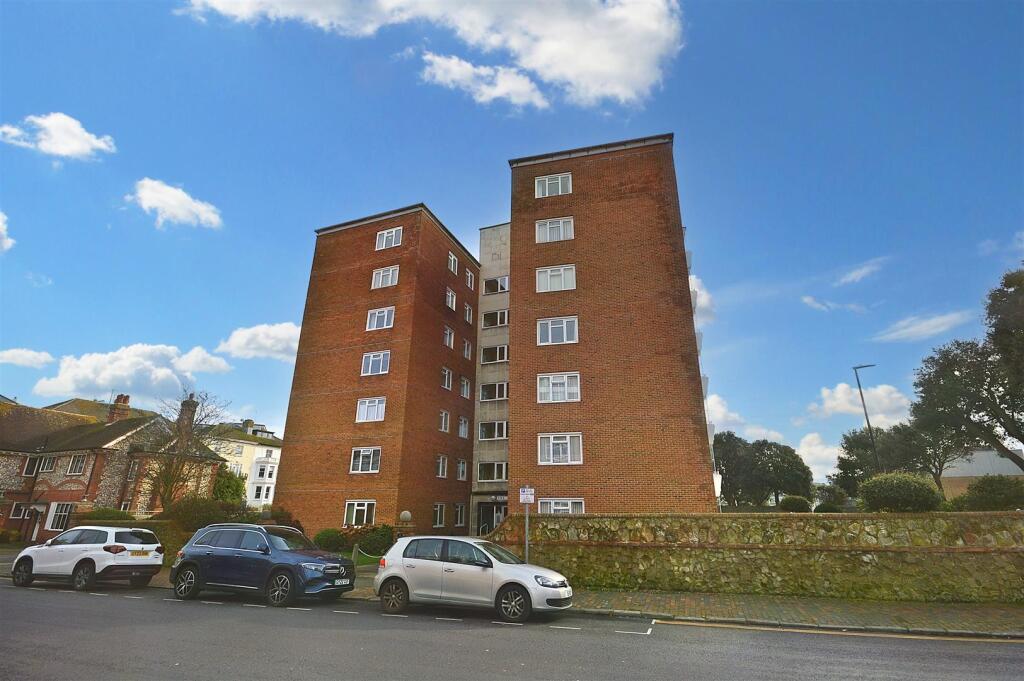
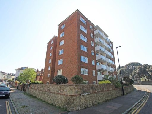
- This well-presented third-floor apartment offers impressive views over the nearby tennis courts at Devonshire Park. Situated in a sizeable red-brick building, the apartment comprises three bedrooms, a spacious living/dining room with patio doors leading to a sun balcony, a fitted kitchen, and one bathroom with a separate WC. The property's notable features include double glazing and electric heating, while the rooms afford an average size. The apartment enjoys a convenient location within walking distance to the town center, railway station, and local theatres, making it particularly appealing for those who appreciate urban conveniences and leisure amenities.
Image Descriptions
- apartment building mid-century modern
- living room Modern
Floorplan Description
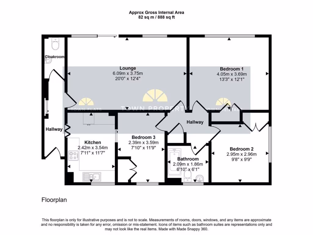
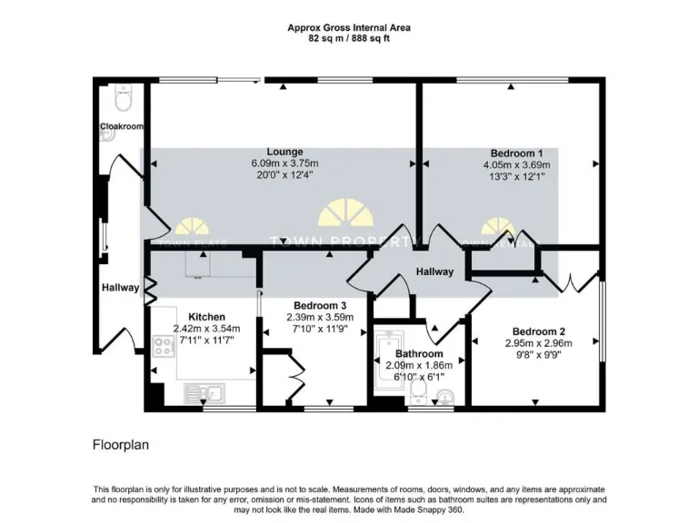
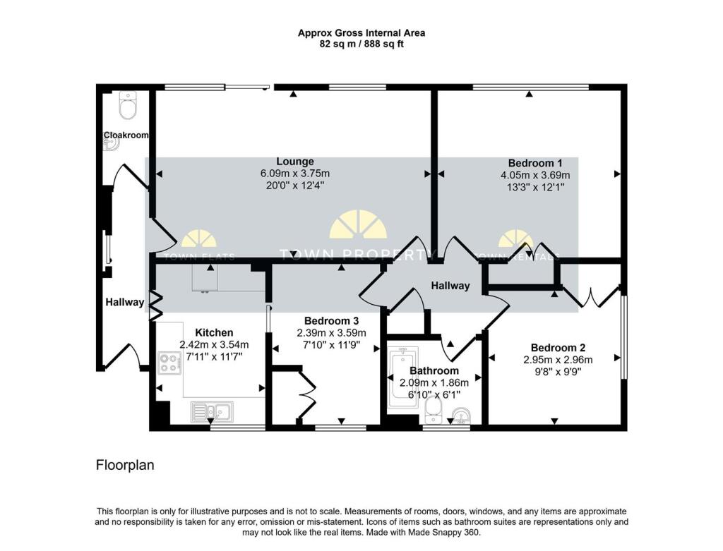
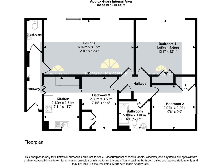
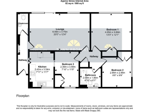
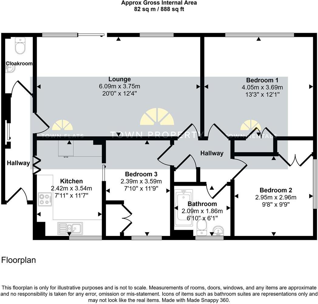
- A flat consisting of three bedrooms, a lounge, kitchen, cloakroom, and a bathroom.
Rooms
- Cloakroom: Small
- Lounge: Large
- Kitchen: Average
- Bedroom 1: Large
- Bedroom 2: Average
- Bedroom 3: Average
- Bathroom: Small
Textual Property Features
- Has Garden
- Chain Free
- Success
Detected Visual Features
- apartment building
- mid-century modern
- brick exterior
- balconies
- urban setting
- multi-story
- modern
- apartment
- living room
- balcony
- large room
- natural light
- updating needed
- date fixtures
EPC Details
- Fully double glazed
- Cavity wall, as built, no insulation (assumed)
- Boiler and radiators, mains gas
- Low energy lighting in 20% of fixed outlets
- (another dwelling below)
Nearby Schools
- Gildredge House
- Pashley Down Infant School
- Stafford Junior School
- St Andrew's Church of England Infants School
- West Rise Community Infant School
- Oakwood Primary Academy
- St John's Meads Church of England Primary School
- Motcombe Infants' School
- West Rise Junior School
- The Eastbourne Academy
- The Turing School
- Eastbourne College
- Bourne Primary School
- St Thomas A Becket Catholic Primary School
- The Cavendish School
- Ocklynge Junior School
- Ratton School
- Parkland Infant School
- Parkland Junior School
- Bede's Prep School
- St Andrew's Prep
- Roselands Infants' School
- Tollgate Community Junior School
- The Haven Church of England Methodist Primary School
- Heron Park Primary Academy
Nearest General Shops
- Id: 579971639
- Tags:
- Addr:
- City: Eastbourne
- Postcode: BN21 4LB
- Name: Neil's Collectables & Antiques
- Shop: antiques
- TagsNormalized:
- Lat: 50.7662936
- Lon: 0.2843667
- FullGeoHash: u100y3xp45p1
- PartitionGeoHash: u100
- Images:
- FoodStandards: null
- Distance: 200
,- Id: 579971638
- Tags:
- Addr:
- City: Eastbourne
- Housenumber: 108
- Postcode: BN21 4LZ
- Street: South Street
- Name: The Eastbourne Hearing Centre Ltd
- Shop: hearing_aids
- TagsNormalized:
- Lat: 50.7662761
- Lon: 0.284295
- FullGeoHash: u100y3xnbxc8
- PartitionGeoHash: u100
- Images:
- FoodStandards: null
- Distance: 198
,- Id: 821625152
- Tags:
- Addr:
- City: Eastbourne
- Housenumber: 106
- Postcode: BN21 4LZ
- Street: South Street
- Building: yes
- Name: The Lightshop
- Shop: lighting
- TagsNormalized:
- Lat: 50.7662478
- Lon: 0.2841881
- FullGeoHash: u100y3wyy46p
- PartitionGeoHash: u100
- Images:
- FoodStandards: null
- Distance: 195.1
}
Nearest Grocery shops
- Id: 576501717
- Tags:
- Addr:
- City: Eastbourne
- Housenumber: 204-206
- Postcode: BN21 3DF
- Street: Terminus Road
- Branch: Terminus Road
- Brand: Best-one
- Brand:wikidata: Q4896532
- Brand:wikipedia: en:Best-one
- Building: yes
- Fhrs:
- Level: 0
- Name: Best-one
- Opening_hours: Mo-Sa 07:00-23:00; Su 07:00-22:30
- Operator: Blakemore Retail
- Shop: convenience
- Source:
- Addr: FSA Food Hygiene Rating Scheme open data
- TagsNormalized:
- Lat: 50.7672261
- Lon: 0.2891601
- FullGeoHash: u100y9fs9bv7
- PartitionGeoHash: u100
- Images:
- FoodStandards: null
- Distance: 456.5
,- Id: 868461896
- Tags:
- Name: Sunny Foods
- Shop: health_food
- TagsNormalized:
- health
- health food
- food
- shop
- Lat: 50.7662396
- Lon: 0.279289
- FullGeoHash: u100y3eqgbuz
- PartitionGeoHash: u100
- Images:
- FoodStandards: null
- Distance: 403.1
,- Id: 579831170
- Tags:
- Addr:
- City: Eastbourne
- Housenumber: 25-29
- Postcode: BN21 4QD
- Street: Cornfield Road
- Brand: Co-op Food
- Brand:wikidata: Q3277439
- Brand:wikipedia: en:Co-op Food
- Fhrs:
- Level: 0
- Name: Co-op Food
- Note: Appears to be a Co-operative Group store, rather than any of the other co-operatives using this branding but I'm not completely certain.
- Operator: The Co-operative Group
- Operator:wikidata: Q117202
- Shop: convenience
- TagsNormalized:
- co-op
- co-op food
- food
- convenience
- shop
- Lat: 50.7675255
- Lon: 0.2848445
- FullGeoHash: u100y3zqm2em
- PartitionGeoHash: u100
- Images:
- FoodStandards:
- Id: 139281
- FHRSID: 139281
- LocalAuthorityBusinessID: 74835
- BusinessName: The Co-op
- BusinessType: Retailers - supermarkets/hypermarkets
- BusinessTypeID: 7840
- AddressLine1: 25-29 Cornfield Road
- AddressLine2: Eastbourne
- AddressLine3: East Sussex
- AddressLine4: null
- PostCode: BN21 4QD
- RatingValue: 5
- RatingKey: fhrs_5_en-GB
- RatingDate: 2022-03-31
- LocalAuthorityCode: 102
- LocalAuthorityName: Eastbourne
- LocalAuthorityWebSite: https://www.lewes-eastbourne.gov.uk
- LocalAuthorityEmailAddress: customer_first@lewes-eastbourne.gov.uk
- Scores:
- Hygiene: 0
- Structural: 0
- ConfidenceInManagement: 0
- NewRatingPending: false
- Geocode:
- Longitude: 0.28471800000000
- Latitude: 50.76750200000000
- Distance: 339
}
Nearest Supermarkets
- Id: 683865127
- Tags:
- Addr:
- City: Eastbourne
- Housenumber: 21
- Postcode: BN23 6QD
- Street: Lottbridge Drove
- Brand: Tesco Extra
- Brand:wikidata: Q25172225
- Brand:wikipedia: en:Tesco Extra
- Building: retail
- Name: Tesco Extra
- Opening_hours: 24/7
- Payment:
- Cash: yes
- Maestro: yes
- Mastercard: yes
- Visa: yes
- Visa_electron: yes
- Phone: +44 345 6779243
- Shop: supermarket
- Website: https://www.tesco.com/store-locator/eastbourne/21-lottbridge-drove
- Wheelchair: yes
- TagsNormalized:
- tesco
- tesco extra
- retail
- supermarket
- shop
- Lat: 50.7859685
- Lon: 0.3035168
- FullGeoHash: u100yvm18qww
- PartitionGeoHash: u100
- Images:
- FoodStandards: null
- Distance: 2743.1
,- Id: 34247357
- Tags:
- Brand: Waitrose
- Brand:wikidata: Q771734
- Brand:wikipedia: en:Waitrose
- Building: retail
- Name: Waitrose
- Official_name: Waitrose & Partners
- Opening_hours: Mo-Fr 08:00-21:00; Sa 08:00-20:00; Su 10:00-16:00
- Operator: Waitrose & Partners
- Shop: supermarket
- TagsNormalized:
- waitrose
- retail
- supermarket
- shop
- Lat: 50.7727956
- Lon: 0.267936
- FullGeoHash: u100y4ghgr5e
- PartitionGeoHash: u100
- Images:
- FoodStandards: null
- Distance: 1475.9
,- Id: 821625176
- Tags:
- Branch: Eastbourne
- Brand: Sainsbury's
- Brand:wikidata: Q152096
- Brand:wikipedia: en:Sainsbury's
- Level: 0
- Name: Sainsbury's
- Opening_hours: Mo-We 08:00-18:00; Th,Fr 08:00-19:00; Sa 07:30-18:00; Su 10:30-16:30
- Shop: supermarket
- TagsNormalized:
- sainsburys
- supermarket
- shop
- Lat: 50.769727
- Lon: 0.2851478
- FullGeoHash: u100y6reh7jd
- PartitionGeoHash: u100
- Images:
- FoodStandards: null
- Distance: 584.7
}
Nearest Religious buildings
- Id: 668630619
- Tags:
- Amenity: place_of_worship
- Building: church
- Denomination: anglican
- Name: Trinity Church
- Religion: christian
- Website: https://holytrinityeastbourne.org.uk/
- Wikidata: Q17555426
- TagsNormalized:
- place of worship
- church
- anglican
- christian
- Lat: 50.766853
- Lon: 0.2881967
- FullGeoHash: u100y9cf77r4
- PartitionGeoHash: u100
- Images:
- FoodStandards: null
- Distance: 378.6
,- Id: 291398478
- Tags:
- Addr:
- City: Eastbourne
- Housename: Eastbourne House
- Housenumber: 22-24
- Postcode: BN21 4SA
- Street: Gildredge Road
- Amenity: place_of_worship
- Building: yes
- Name: Eastbourne House
- TagsNormalized:
- Lat: 50.7673248
- Lon: 0.2817916
- FullGeoHash: u100y3vjn5r0
- PartitionGeoHash: u100
- Images:
- FoodStandards: null
- Distance: 361.2
,- Id: 253017179
- Tags:
- Addr:
- City: Eastbourne
- Postcode: BN21 4UT
- Street: South Street
- Amenity: place_of_worship
- Building: church
- Denomination: anglican
- Name: St Saviour's Church
- Religion: christian
- Source: OS_Opendata_Streetview
- Wikidata: Q17555438
- TagsNormalized:
- place of worship
- church
- anglican
- christian
- Lat: 50.765945
- Lon: 0.2829738
- FullGeoHash: u100y3wj1f09
- PartitionGeoHash: u100
- Images:
- FoodStandards: null
- Distance: 186.7
}
Nearest Medical buildings
- Id: 4771436180
- Tags:
- Amenity: doctors
- Healthcare: doctor
- Name: Bolton House
- TagsNormalized:
- doctor
- doctors
- health
- healthcare
- Lat: 50.7676285
- Lon: 0.285945
- FullGeoHash: u100y9bnz5bh
- PartitionGeoHash: u100
- Images:
- FoodStandards: null
- Distance: 366.8
,- Id: 530674514
- Tags:
- Amenity: pharmacy
- Healthcare: pharmacy
- TagsNormalized:
- Lat: 50.7658693
- Lon: 0.281007
- FullGeoHash: u100y3ssegyn
- PartitionGeoHash: u100
- Images:
- FoodStandards: null
- Distance: 278.3
,- Id: 1043479341
- Tags:
- Amenity: clinic
- Building: yes
- Healthcare: clinic
- Healthcare:speciality: obstetric_ultrasonography
- Name: Window to the Womb
- Operator: Window to the Womb
- Phone: 01323368400
- Website: https://windowtothewomb.co.uk/find-a-clinic/eastbourne-baby-scan-clinic/
- TagsNormalized:
- Lat: 50.7663149
- Lon: 0.2817858
- FullGeoHash: u100y3tpnp48
- PartitionGeoHash: u100
- Images:
- FoodStandards: null
- Distance: 269.3
,- Id: 5405368324
- Tags:
- Addr:
- Housename: Trinity House
- Housenumber: 1
- Postcode: BN21 3LA
- Street: Trinity Trees
- Amenity: clinic
- Healthcare: clinic
- Name: Cardiovascular Healthcare
- Phone: +44 1323 410400
- TagsNormalized:
- Lat: 50.7665961
- Lon: 0.2858546
- FullGeoHash: u100y9b0ugkt
- PartitionGeoHash: u100
- Images:
- FoodStandards: null
- Distance: 257.5
}
Nearest Leisure Facilities
- Id: 1043817143
- Tags:
- TagsNormalized:
- outdoor
- outdoor seating
- leisure
- Lat: 50.7632429
- Lon: 0.2880535
- FullGeoHash: u100y91v24k7
- PartitionGeoHash: u100
- Images:
- FoodStandards: null
- Distance: 297.6
,- Id: 577316874
- Tags:
- TagsNormalized:
- Lat: 50.7635319
- Lon: 0.2882204
- FullGeoHash: u100y91zh00w
- PartitionGeoHash: u100
- Images:
- FoodStandards: null
- Distance: 294.9
,- Id: 1043817135
- Tags:
- Leisure: sports_centre
- Name: Winn Sports Hall @ Eastbourne College
- TagsNormalized:
- sports
- sports centre
- leisure
- college
- sports hall
- Lat: 50.7627239
- Lon: 0.2812398
- FullGeoHash: u100y3hf33ee
- PartitionGeoHash: u100
- Images:
- FoodStandards: null
- Distance: 292.5
,- Id: 577316873
- Tags:
- TagsNormalized:
- Lat: 50.7629865
- Lon: 0.287569
- FullGeoHash: u100y917ufdc
- PartitionGeoHash: u100
- Images:
- FoodStandards: null
- Distance: 283.8
,- Id: 669991734
- Tags:
- TagsNormalized:
- sports
- sports centre
- leisure
- Lat: 50.7638091
- Lon: 0.2836129
- FullGeoHash: u100y3q88evh
- PartitionGeoHash: u100
- Images:
- FoodStandards: null
- Distance: 90.9
}
Nearest Tourist attractions
- Id: 6979877286
- Tags:
- Addr:
- Housenumber: 101-111
- Street: South Street
- Name: Mayfair House
- Tourism: attraction
- TagsNormalized:
- Lat: 50.7665605
- Lon: 0.2838485
- FullGeoHash: u100y3y8whuc
- PartitionGeoHash: u100
- Images:
- FoodStandards: null
- Distance: 231.9
,- Id: 822219093
- Tags:
- Addr:
- City: Eastbourne
- Postcode: BN21 4JJ
- Street: College Road
- Building: yes
- Fee: no
- Name: Towner Art Gallery
- Opening_hours:
- Tourism: gallery
- TagsNormalized:
- Lat: 50.7627388
- Lon: 0.2829053
- FullGeoHash: u100y3n42hm7
- PartitionGeoHash: u100
- Images:
- FoodStandards: null
- Distance: 219
,- Id: 8711841748
- Tags:
- Internet_access: yes
- Internet_access:fee: customers
- Name: The Sheldon B&B
- Smoking: outside
- Tourism: guest_house
- TagsNormalized:
- Lat: 50.7646723
- Lon: 0.2864118
- FullGeoHash: u100y92t9uu1
- PartitionGeoHash: u100
- Images:
- FoodStandards: null
- Distance: 148.9
}
Nearest Train stations
- Id: 6745675394
- Tags:
- Name: Polegate
- Naptan:
- Network: National Rail
- Public_transport: station
- Railway: station
- Ref:
- Wikidata: Q1928088
- Wikipedia: en:Polegate railway station
- TagsNormalized:
- Lat: 50.8211277
- Lon: 0.2467483
- FullGeoHash: u101jeewt8ug
- PartitionGeoHash: u101
- Images:
- FoodStandards: null
- Distance: 6828.4
,- Id: 6745645284
- Tags:
- Name: Pevensey and Westham
- Naptan:
- Network: National Rail
- Public_transport: station
- Railway: station
- Ref:
- Wikidata: Q2280818
- Wikipedia: en:Pevensey & Westham railway station
- TagsNormalized:
- Lat: 50.8157704
- Lon: 0.3253781
- FullGeoHash: u101p6szmf5m
- PartitionGeoHash: u101
- Images:
- FoodStandards: null
- Distance: 6390.6
,- Id: 6745675396
- Tags:
- Name: Hampden Park
- Naptan:
- Network: National Rail
- Platforms: 2
- Public_transport: station
- Railway: station
- Ref:
- Source: NPE
- Wheelchair: no
- Wikidata: Q2163730
- Wikipedia: en:Hampden Park railway station
- TagsNormalized:
- Lat: 50.7959254
- Lon: 0.2796796
- FullGeoHash: u100yr5etnb1
- PartitionGeoHash: u100
- Images:
- FoodStandards: null
- Distance: 3510
,- Id: 1252781690
- Tags:
- Name: Eastbourne Miniature Steam Railway
- Public_transport: station
- Railway: station
- Usage: tourism
- TagsNormalized:
- Lat: 50.7882891
- Lon: 0.2874059
- FullGeoHash: u100yt9r1p33
- PartitionGeoHash: u100
- Images:
- FoodStandards: null
- Distance: 2654.7
,- Id: 6745675395
- Tags:
- Name: Eastbourne
- Naptan:
- Network: National Rail
- Public_transport: station
- Railway: station
- Ref:
- Wikidata: Q800700
- Wikimedia_commons: Category:Eastbourne railway station
- Wikipedia: en:Eastbourne railway station
- TagsNormalized:
- Lat: 50.7696435
- Lon: 0.2815355
- FullGeoHash: u100y6m48780
- PartitionGeoHash: u100
- Images:
- FoodStandards: null
- Distance: 604.9
}
Nearest Bus stations and stops
- Id: 983865042
- Tags:
- Bench: yes
- Bus: yes
- Highway: bus_stop
- Name: Compton Street
- Public_transport: platform
- Shelter: no
- TagsNormalized:
- Lat: 50.7651756
- Lon: 0.287624
- FullGeoHash: u100y992w4eu
- PartitionGeoHash: u100
- Images:
- FoodStandards: null
- Distance: 244.8
,- Id: 8807386648
- Tags:
- Bench: no
- Bin: no
- Bus: yes
- Highway: bus_stop
- Local_ref: M1
- Name: Memorial Roundabout
- Public_transport: platform
- Shelter: no
- Tactile_paving: no
- TagsNormalized:
- Lat: 50.7664263
- Lon: 0.2842257
- FullGeoHash: u100y3wzygy0
- PartitionGeoHash: u100
- Images:
- FoodStandards: null
- Distance: 214.8
,- Id: 983011198
- Tags:
- Bench: no
- Bus: yes
- Highway: bus_stop
- Name: Winter Gardens
- Public_transport: platform
- Shelter: no
- TagsNormalized:
- Lat: 50.7627855
- Lon: 0.285183
- FullGeoHash: u100y3pdtjpf
- PartitionGeoHash: u100
- Images:
- FoodStandards: null
- Distance: 199.7
,- Id: 983865081
- Tags:
- Bench: no
- Bin: no
- Bus: yes
- Highway: bus_stop
- Name: Winter Gardens
- Public_transport: platform
- Shelter: no
- Tactile_paving: no
- TagsNormalized:
- Lat: 50.7627967
- Lon: 0.284817
- FullGeoHash: u100y3p6sxnv
- PartitionGeoHash: u100
- Images:
- FoodStandards: null
- Distance: 192.2
,- Id: 983865035
- Tags:
- Bench: no
- Bin: no
- Bus: yes
- Highway: bus_stop
- Name: Howard Gardens
- Public_transport: platform
- Shelter: no
- Tactile_paving: no
- TagsNormalized:
- Lat: 50.7641232
- Lon: 0.2864772
- FullGeoHash: u100y92d7qky
- PartitionGeoHash: u100
- Images:
- FoodStandards: null
- Distance: 157.7
}
Nearest Hotels
- Id: 577316887
- Tags:
- Building: yes
- Building:colour: light_yellow
- Building:levels: 4
- Building:material: plaster
- Name: The Albany Hotel (Lions)
- Roof:
- Tourism: hotel
- TagsNormalized:
- Lat: 50.7639446
- Lon: 0.2878227
- FullGeoHash: u100y9396v0h
- PartitionGeoHash: u100
- Images:
- FoodStandards: null
- Distance: 254.3
,- Id: 577316886
- Tags:
- Addr:
- City: Eastbourne
- Housename: West Rocks Hotel
- Housenumber: 44
- Postcode: BN21 4DL
- Street: Grand Parade
- Building: yes
- Building:levels: 4
- Internet_access: wlan
- Internet_access:fee: customers
- Name: West Rocks Townhouse Hotel
- Roof:
- Rooms: 47
- Source: local knowledge;website
- Tourism: hotel
- Website: https://www.westrockshotel.com/
- TagsNormalized:
- Lat: 50.7637379
- Lon: 0.2875962
- FullGeoHash: u100y932jqx7
- PartitionGeoHash: u100
- Images:
- FoodStandards: null
- Distance: 245.7
,- Id: 577316880
- Tags:
- Addr:
- City: Eastbourne
- Postcode: BN21 4DN
- Street: Grand Parade
- Building: yes
- Building:levels: 9
- Name: The View Hotel
- Roof:
- Tourism: hotel
- TagsNormalized:
- Lat: 50.7632393
- Lon: 0.2869635
- FullGeoHash: u100y90vq9xm
- PartitionGeoHash: u100
- Images:
- FoodStandards: null
- Distance: 232.9
}
Tags
- apartment building
- mid-century modern
- brick exterior
- balconies
- urban setting
- multi-story
- modern
- apartment
- living room
- balcony
- large room
- natural light
- updating needed
- date fixtures
Local Market Stats
- Average Price/sqft: £304
- Avg Income: £43000
- Rental Yield: 4.4%
- Social Housing: 9%
- Planning Success Rate: 88%
AirBnB Data
- 1km average: £87/night
- Listings in 1km: 23
Similar Properties
 3 bedroom flat for sale in Blackwater Road, Eastbourne, BN21 4JF, BN21 — £259,950 • 3 bed • 1 bath • 915 ft²
 3 bedroom flat for sale in Grassington Road, Eastbourne, BN20 — £350,000 • 3 bed • 2 bath • 926 ft²
 2 bedroom flat for sale in Blackwater Road, Eastbourne, BN21 — £259,950 • 2 bed • 1 bath • 904 ft²
 2 bedroom flat for sale in Blackwater Road, Eastbourne, BN21 — £225,000 • 2 bed • 1 bath • 791 ft²
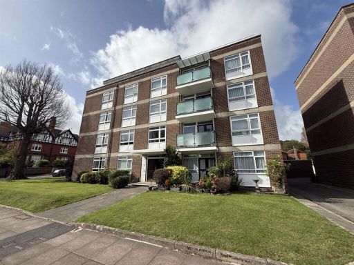 3 bedroom flat for sale in Granville Road, Eastbourne, BN20 — £245,000 • 3 bed • 1 bath • 685 ft²
 3 bedroom penthouse for sale in Grassington Road, Eastbourne, BN20 7BG, BN20 — £550,000 • 3 bed • 2 bath • 1389 ft²
Meta
- {
"@context": "https://schema.org",
"@type": "Residence",
"name": "3 bedroom flat for sale in Blackwater Road, Eastbourne, BN21",
"description": "",
"url": "https://propertypiper.co.uk/property/710ad18e-ea91-4e5d-916b-45c23f99f627",
"image": "https://image-a.propertypiper.co.uk/8ddde417-2882-4ef7-aaec-14daa0f8f6a0-1024.jpeg",
"address": {
"@type": "PostalAddress",
"streetAddress": "THE LODGE, 3 FLAT 10 BLACKWATER ROAD EASTBOURNE",
"postalCode": "BN21 4JF",
"addressLocality": "Eastbourne",
"addressRegion": "Eastbourne",
"addressCountry": "England"
},
"geo": {
"@type": "GeoCoordinates",
"latitude": 50.764495420983955,
"longitude": 0.28431375140830006
},
"numberOfRooms": 3,
"numberOfBathroomsTotal": 1,
"floorSize": {
"@type": "QuantitativeValue",
"value": 888,
"unitCode": "FTK"
},
"offers": {
"@type": "Offer",
"price": 259950,
"priceCurrency": "GBP",
"availability": "https://schema.org/InStock"
},
"additionalProperty": [
{
"@type": "PropertyValue",
"name": "Feature",
"value": "apartment building"
},
{
"@type": "PropertyValue",
"name": "Feature",
"value": "mid-century modern"
},
{
"@type": "PropertyValue",
"name": "Feature",
"value": "brick exterior"
},
{
"@type": "PropertyValue",
"name": "Feature",
"value": "balconies"
},
{
"@type": "PropertyValue",
"name": "Feature",
"value": "urban setting"
},
{
"@type": "PropertyValue",
"name": "Feature",
"value": "multi-story"
},
{
"@type": "PropertyValue",
"name": "Feature",
"value": "modern"
},
{
"@type": "PropertyValue",
"name": "Feature",
"value": "apartment"
},
{
"@type": "PropertyValue",
"name": "Feature",
"value": "living room"
},
{
"@type": "PropertyValue",
"name": "Feature",
"value": "balcony"
},
{
"@type": "PropertyValue",
"name": "Feature",
"value": "large room"
},
{
"@type": "PropertyValue",
"name": "Feature",
"value": "natural light"
},
{
"@type": "PropertyValue",
"name": "Feature",
"value": "updating needed"
},
{
"@type": "PropertyValue",
"name": "Feature",
"value": "date fixtures"
}
]
}
High Res Floorplan Images
Compatible Floorplan Images
FloorplanImages Thumbnail