GL3 4SL - Land for sale in Lot 3 Land At The Peak, Birdlip Hill, Witc…
View on Property Piper
Land for sale in Lot 3 Land At The Peak, Birdlip Hill, Witcombe, Gloucester, Gloucestershire, GL3
Property Details
- Price: £10000
- Bedrooms: 1
- Bathrooms: 1
- Property Type: undefined
- Property SubType: undefined
Brochure Descriptions
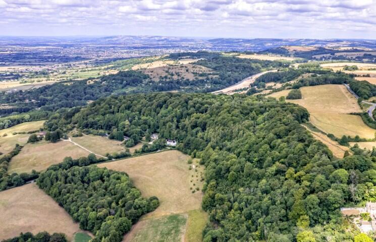
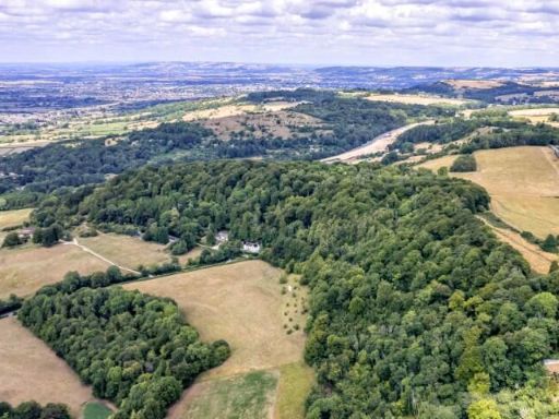
- The property for sale is a large block of broadleaf woodland outlined on the aerial image, located in a rural and scenic part of Birdlip Hill, overlooking rolling countryside. The block extends to approximately 26 acres and comprises a contiguous forested area, surrounded by farmland and some scattered residential dwellings. Views are exceptional, with sweeping vistas of open countryside and distant hills visible from the higher points of the land. No residential buildings or developed structures are included within the outlined property; it is purely woodland, suitable for conservation, leisure, or potential forestry uses. The property size is very large (26 acres).
- The property for sale is a parcel of land located on Birdlip Hill in Birdlip, Gloucester. From the map, it is situated in a semi-rural location surrounded by countryside and woodland, indicative of expansive and scenic views, likely over forested or valley areas. The property is not a built residence but rather vacant land, so there are no rooms to describe. The size is reasonably large, suitable for agricultural, recreational, or potential development use, given its placement among large fields and woodland patches.
- The property for sale comprises substantial parcels of land known as The Peak Plantation. It is divided into three lots: Lot 1 is a large woodland area of approximately 18 acres with direct access to a classified highway and several public footpaths crossing, ideal for forestry or leisure pursuits. Lot 2 consists of about 7.7 acres, also crossed by public rights of way, suitable for similar uses. Lot 3 is about 0.75 acres, smaller and accessed via an established right of way, with no public rights of way over this lot. All lots appear to be attractive, predominantly woodland parcels with gently undulating land and adjoining open countryside—likely to offer tranquil woodland views and a sense of privacy. Overall, the property is large, almost 27 acres, suitable for those looking for significant woodland or rewilding opportunities.
Image Descriptions
- country estate with expansive woodland
Textual Property Features
Detected Visual Features
- country estate
- expansive property
- woodland
- secluded
- natural setting
- rural
Nearby Schools
- Miserden Church of England Primary School
- Sheepscombe Primary School
- Castle Hill Primary School
- Henley Bank High School
- The Richard Pate School
- Warden Hill Primary School
- Naunton Park Primary School
- Dean Close School
- Coopers Edge School
- Coberley Church of England Primary School
- The High School Leckhampton
- St Mark's Church of England Junior School
- Benhall Infant School
- Cranham Church of England Primary School
- Birdlip Primary School
- Shurdington Church of England Primary School
- Leckhampton Church of England Primary School
- Chosen Hill School
- Greatfield Park Primary School
- St James' Church of England Primary School
- Cheltenham Bournside School and Sixth Form Centre
- Lakeside Primary School
- Dean Close Preparatory School
- Dean Close Airthrie
- Brockworth Primary Academy
- Cheltenham College
- Christ Church CofE Primary School
Nearest General Shops
- Id: 2882367039
- Tags:
- Name: Shurdington Nurseries
- Shop: plant_nursery
- Source: survey
- Source:name: OS_OpenData_StreetView
- TagsNormalized:
- Lat: 51.8548536
- Lon: -2.1248783
- FullGeoHash: gcnqzxusqtrf
- PartitionGeoHash: gcnq
- Images:
- FoodStandards: null
- Distance: 2687.4
,- Id: 1055126846
- Tags:
- Building: yes
- Name: Gloucester Mixed Feeds
- Shop: pet
- Website: http://www.gloucestermixfeeds.com/
- TagsNormalized:
- Lat: 51.8365178
- Lon: -2.1460864
- FullGeoHash: gcnqzht38e3c
- PartitionGeoHash: gcnq
- Images:
- FoodStandards: null
- Distance: 2396.5
,- Id: 833604440
- Tags:
- Addr:
- City: Gloucester
- Housename: Grove Farm
- Postcode: GL3 4UH
- Village: Witcombe
- Landuse: retail
- Name: Crickley Hill Tractors
- Shop: car
- Source:
- TagsNormalized:
- Lat: 51.8406037
- Lon: -2.103123
- FullGeoHash: gcnwbjk93svy
- PartitionGeoHash: gcnw
- Images:
- FoodStandards: null
- Distance: 1129.9
}
Nearest Grocery shops
- Id: 348768960
- Tags:
- Brand: Co-op Food
- Brand:wikidata: Q3277439
- Brand:wikipedia: en:Co-op Food
- Name: Co-op Food
- Opening_hours: Mo-Sa 07:00-22:00; Su 08:00-22:00
- Operator: The Co-operative Group
- Operator:wikidata: Q117202
- Shop: convenience
- Source: local_knowledge
- TagsNormalized:
- co-op
- co-op food
- food
- convenience
- shop
- Lat: 51.8442478
- Lon: -2.156971
- FullGeoHash: gcnqyvvqdumb
- PartitionGeoHash: gcnq
- Images:
- FoodStandards: null
- Distance: 3376.8
,- Id: 1122924016
- Tags:
- Brand: Shell Select
- Brand:wikidata: Q110716465
- Building: yes
- Name: Shell Select
- Shop: convenience
- TagsNormalized:
- shell
- shell select
- convenience
- shop
- Lat: 51.8420164
- Lon: -2.1490371
- FullGeoHash: gcnqzje1eu3c
- PartitionGeoHash: gcnq
- Images:
- FoodStandards: null
- Distance: 2778
,- Id: 331968353
- Tags:
- Addr:
- Housenumber: 10
- Street: Astridge Road
- Fixme: PO closed, but is this still a shop?
- Shop: convenience
- Source: survey
- TagsNormalized:
- Lat: 51.8408913
- Lon: -2.1385097
- FullGeoHash: gcnqzm6g14ed
- PartitionGeoHash: gcnq
- Images:
- FoodStandards: null
- Distance: 2072.2
}
Nearest Supermarkets
- Id: 25347825
- Tags:
- Addr:
- City: Gloucester
- Country: GB
- Postcode: GL4 4FF
- Street: Heron Way
- Alt_name: Morrisons Glevum Shopping Centre
- Brand: Morrisons
- Brand:wikidata: Q922344
- Brand:wikipedia: en:Morrisons
- Name: Morrisons
- Operator: Morrisons
- Shop: supermarket
- Website: https://my.morrisons.com/storefinder/142
- TagsNormalized:
- Lat: 51.8415663
- Lon: -2.2054838
- FullGeoHash: gcnqvv6p082h
- PartitionGeoHash: gcnq
- Images:
- FoodStandards: null
- Distance: 6511.9
,- Id: 462992338
- Tags:
- Addr:
- City: Cheltenham
- Postcode: GL51 3BW
- Street: Caernarvon Road
- Brand: Morrisons
- Brand:wikidata: Q922344
- Brand:wikipedia: en:Morrisons
- Building: retail
- Building:levels: 1
- Name: Morrisons
- Opening_hours: Mo-Sa 07:00-23:00; Su 10:00-16:00
- Payment:
- Shop: supermarket
- Website: https://my.morrisons.com/storefinder/326
- TagsNormalized:
- morrisons
- retail
- supermarket
- shop
- Lat: 51.8800704
- Lon: -2.1084235
- FullGeoHash: gcnx0h2xq4j6
- PartitionGeoHash: gcnx
- Images:
- FoodStandards: null
- Distance: 5346.4
,- Id: 39789356
- Tags:
- Addr:
- City: Gloucester
- Postcode: GL3 4AA
- Street: Delta Way
- Brand: Tesco Extra
- Brand:wikidata: Q25172225
- Brand:wikipedia: en:Tesco Extra
- Building: yes
- Check_date: 2023-02-13
- Contact:
- Website: https://www.tesco.com/store-locator/gloucester/gloucester-business-park
- Name: Tesco Extra
- Operator: Tesco
- Payment:
- Shop: supermarket
- Source: Bing;survey
- Wheelchair: yes
- TagsNormalized:
- tesco
- tesco extra
- supermarket
- shop
- Lat: 51.848769
- Lon: -2.1717721
- FullGeoHash: gcnqywf8fp16
- PartitionGeoHash: gcnq
- Images:
- FoodStandards: null
- Distance: 4510.1
}
Nearest Religious buildings
- Id: 39224325
- Tags:
- Amenity: grave_yard
- Denomination: anglican
- Name: Saint Peter's Churchyard
- Note: The churchyard is Saint Peter's
- Religion: christian
- TagsNormalized:
- grave yard
- anglican
- church
- christian
- Lat: 51.8436127
- Lon: -2.124377
- FullGeoHash: gcnqztv4fmve
- PartitionGeoHash: gcnq
- Images:
- FoodStandards: null
- Distance: 1543.7
,- Id: 882736484
- Tags:
- Amenity: place_of_worship
- Building: church
- Denomination: anglican
- Ele: 102.5054932
- Name: Saint Mary the Virgin
- Religion: christian
- Wikidata: Q17526306
- TagsNormalized:
- place of worship
- church
- anglican
- christian
- Lat: 51.8317193
- Lon: -2.131178
- FullGeoHash: gcnqze8jeuy9
- PartitionGeoHash: gcnq
- Images:
- FoodStandards: null
- Distance: 1320.4
,- Id: 449683059
- Tags:
- Addr:
- City: Gloucester
- Postcode: GL4 8JH
- Amenity: place_of_worship
- Building: church
- Denomination: anglican
- Name: Saint Mary in Hamlet
- Note: I know the dedication is rather strange but so is the church and it's history.
- Religion: christian
- Source: OS OpenData StreetView
- Source:name: local knowledge
- Wikidata: Q105097833
- TagsNormalized:
- place of worship
- church
- anglican
- christian
- Lat: 51.826786
- Lon: -2.1066225
- FullGeoHash: gcnwb4f0bjhk
- PartitionGeoHash: gcnw
- Images:
- FoodStandards: null
- Distance: 690
}
Nearest Leisure Facilities
- Id: 833153482
- Tags:
- Access: customers
- Addr:
- City: Gloucester
- Postcode: GL3 4UF
- Street: Crickley Hill
- Village: Witcombe
- Alt_name: Crickley Hill Farm
- Leisure: park
- Name: Flyup 417 Bike Park
- TagsNormalized:
- Lat: 51.8373605
- Lon: -2.114554
- FullGeoHash: gcnqzusnx26k
- PartitionGeoHash: gcnq
- Images:
- FoodStandards: null
- Distance: 617.8
,- Id: 947855058
- Tags:
- Leisure: pitch
- Sport: cricket
- TagsNormalized:
- pitch
- leisure
- cricket
- sports
- Lat: 51.8287463
- Lon: -2.1054818
- FullGeoHash: gcnwb54u6dwf
- PartitionGeoHash: gcnw
- Images:
- FoodStandards: null
- Distance: 576.9
,- Id: 1030738563
- Tags:
- Access: customers
- Garden:
- Leisure: garden
- TagsNormalized:
- Lat: 51.8284936
- Lon: -2.1105453
- FullGeoHash: gcnqzgp4uerq
- PartitionGeoHash: gcnq
- Images:
- FoodStandards: null
- Distance: 406.2
,- Id: 9772069867
- Tags:
- Access: customers
- Leisure: picnic_table
- TagsNormalized:
- picnic
- picnic table
- leisure
- Lat: 51.8285025
- Lon: -2.110694
- FullGeoHash: gcnqzgp4cm0k
- PartitionGeoHash: gcnq
- Images:
- FoodStandards: null
- Distance: 402.9
,- Id: 1063937905
- Tags:
- TagsNormalized:
- Lat: 51.8337071
- Lon: -2.1153764
- FullGeoHash: gcnqzu59hpm4
- PartitionGeoHash: gcnq
- Images:
- FoodStandards: null
- Distance: 298.7
}
Nearest Tourist attractions
- Id: 546617526
- Tags:
- Booth: K6
- Disused:
- Museum: history
- Name: The Brimpsfield Telephone Kiosk
- Public_bookcase:
- Source: survey
- Tourism: museum
- TagsNormalized:
- Lat: 51.8129209
- Lon: -2.0894194
- FullGeoHash: gcnwb2q80uxb
- PartitionGeoHash: gcnw
- Images:
- FoodStandards: null
- Distance: 2630.8
,- Id: 32196058
- Tags:
- HE_ref: 1014826
- Archaeological_site: roman_villa
- Description: The ruins of a fine Roman Country house are to be found on the slopes of Coopers Hill near to Witcombe
- Historic: archaeological_site
- Historic:civilization: ancient_roman
- Listed_status: scheduled_monument
- Name: Great Witcombe Roman Villa
- Operator: English Heritage
- Site_type: roman_villa
- Source: survey
- Tourism: attraction
- Website: https://www.english-heritage.org.uk/visit/places/great-witcombe-roman-villa/
- Wikidata: Q5600255
- Wikipedia: en:Great Witcombe Roman Villa
- TagsNormalized:
- Lat: 51.82677
- Lon: -2.1474122
- FullGeoHash: gcnqz4u2cdjm
- PartitionGeoHash: gcnq
- Images:
- FoodStandards: null
- Distance: 2505
,- Id: 925377188
- Tags:
- Source: survey
- Tourism: camp_site
- TagsNormalized:
- Lat: 51.8138172
- Lon: -2.1266385
- FullGeoHash: gcnqz87mmex6
- PartitionGeoHash: gcnq
- Images:
- FoodStandards: null
- Distance: 2263.1
}
Nearest Hotels
- Id: 7777593936
- Tags:
- Addr:
- City: Gloucester
- Postcode: GL3 4SS
- Street: Ermin Way
- Brand: Premier Inn
- Brand:wikidata: Q2108626
- Internet_access: wlan
- Internet_access:fee: customers
- Internet_access:operator: Virgin Media
- Internet_access:ssid: Premier Inn Free Wi-Fi
- Name: Premier Inn Gloucester (Little Witcombe) Hotel
- Phone: +44 333 003 1676
- Tourism: hotel
- Website: https://www.premierinn.com/gb/en/hotels/england/gloucestershire/gloucester/gloucester-little-witcombe.html
- TagsNormalized:
- Lat: 51.8397912
- Lon: -2.1390505
- FullGeoHash: gcnqzm4kst2r
- PartitionGeoHash: gcnq
- Images:
- FoodStandards: null
- Distance: 2050.7
,- Id: 1059272347
- Tags:
- Brand: Premier Inn
- Brand:wikidata: Q2108626
- Building: yes
- Internet_access: wlan
- Internet_access:fee: customers
- Internet_access:operator: Virgin Media
- Internet_access:ssid: Premier Inn Free Wi-Fi
- Name: Premier Inn Gloucester (Little Witcombe) Hotel
- Phone: +44 333 003 1676
- Tourism: hotel
- Website: https://www.premierinn.com/gb/en/hotels/england/gloucestershire/gloucester/gloucester-little-witcombe.html
- TagsNormalized:
- Lat: 51.8397918
- Lon: -2.1389547
- FullGeoHash: gcnqzm4kwtxg
- PartitionGeoHash: gcnq
- Images:
- FoodStandards: null
- Distance: 2044.7
,- Id: 449683063
- Tags:
- Amenity: pub
- Building: yes
- Name: Royal George Hotel
- Operator: Old English Inns
- Tourism: hotel
- TagsNormalized:
- Lat: 51.8282614
- Lon: -2.1098455
- FullGeoHash: gcnqzgp9t01j
- PartitionGeoHash: gcnq
- Images:
- FoodStandards: null
- Distance: 444.7
}
Tags
- country estate
- expansive property
- woodland
- secluded
- natural setting
- rural
Local Market Stats
- Average Price/sqft: £303
- Avg Income: £51200
- Rental Yield: 4.7%
- Social Housing: 8%
- Planning Success Rate: 90%
AirBnB Data
- 1km average: £128/night
- Listings in 1km: 2
Similar Properties
 Land for sale in Lot 1 Land At The Peak, Birdlip Hill, Witcombe, Gloucester, Gloucestershire, GL3 — £110,000 • 1 bed • 1 bath
 Land for sale in Land At The Peak, Birdlip Hill, Witcombe, Gloucester, Gloucestershire, GL3 — £200,000 • 1 bed • 1 bath
 Land for sale in Lot 2 Land At The Peak, Birdlip Hill, Witcombe, Gloucester, Gloucestershire, GL3 — £80,000 • 1 bed • 1 bath
 House for sale in Lot 2 - Land At Blacklaines Farm, B4070, Birdlip, Gloucestershire, GL4 8LH, GL4 — £700,000 • 1 bed • 1 bath
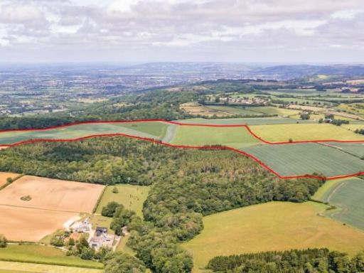 House for sale in Lot 3 - Land At Blacklaines Farm, B4070, Birdlip, Gloucestershire, GL4 8LH, GL4 — £500,000 • 1 bed • 1 bath
 Land for sale in The Whole - Land Near Arundel Drive, Rodborough, Stroud, Gloucestershire, GL5 — £375,000 • 1 bed • 1 bath
Meta
- {
"@context": "https://schema.org",
"@type": "Residence",
"name": "Land for sale in Lot 3 Land At The Peak, Birdlip Hill, Witc…",
"description": "",
"url": "https://propertypiper.co.uk/property/5e8252c8-4067-4448-8db0-224deb7e6b26",
"image": "https://image-a.propertypiper.co.uk/c8a7c5b0-4b6f-4f14-8b99-09d67baac072-1024.jpeg",
"address": {
"@type": "PostalAddress",
"streetAddress": "THE DOWER HOUSE BIRDLIP HILL WITCOMBE GLOUCESTER",
"postalCode": "GL3 4SL",
"addressLocality": "Tewkesbury",
"addressRegion": "Tewkesbury",
"addressCountry": "England"
},
"geo": {
"@type": "GeoCoordinates",
"latitude": 51.8320385697988,
"longitude": -2.111970016462441
},
"numberOfRooms": 1,
"numberOfBathroomsTotal": 1,
"offers": {
"@type": "Offer",
"price": 10000,
"priceCurrency": "GBP",
"availability": "https://schema.org/InStock"
},
"additionalProperty": [
{
"@type": "PropertyValue",
"name": "Feature",
"value": "country estate"
},
{
"@type": "PropertyValue",
"name": "Feature",
"value": "expansive property"
},
{
"@type": "PropertyValue",
"name": "Feature",
"value": "woodland"
},
{
"@type": "PropertyValue",
"name": "Feature",
"value": "secluded"
},
{
"@type": "PropertyValue",
"name": "Feature",
"value": "natural setting"
},
{
"@type": "PropertyValue",
"name": "Feature",
"value": "rural"
}
]
}