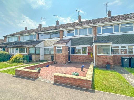
CV10 7LZ - 3 bedroom terraced house for sale in Silver Walk, Nuneaton,…
View on Property Piper
3 bedroom terraced house for sale in Silver Walk, Nuneaton, CV10
Property Details
- Price: £194950
- Bedrooms: 3
- Bathrooms: 1
- Property Type: undefined
- Property SubType: undefined
Image Descriptions
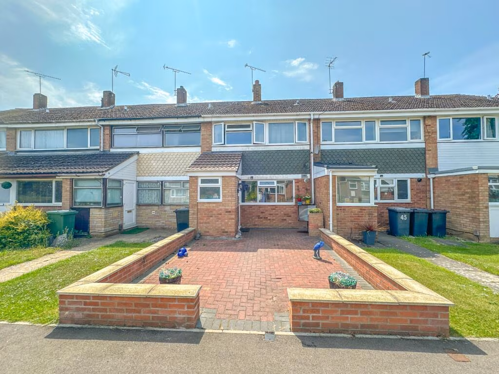
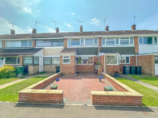
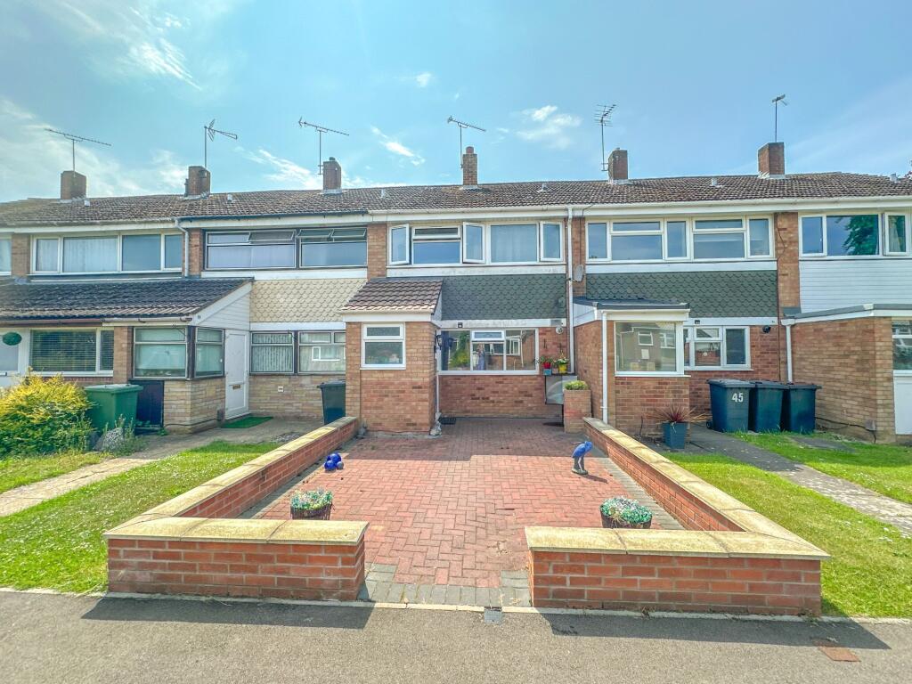
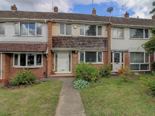
- terraced house Mid-20th Century
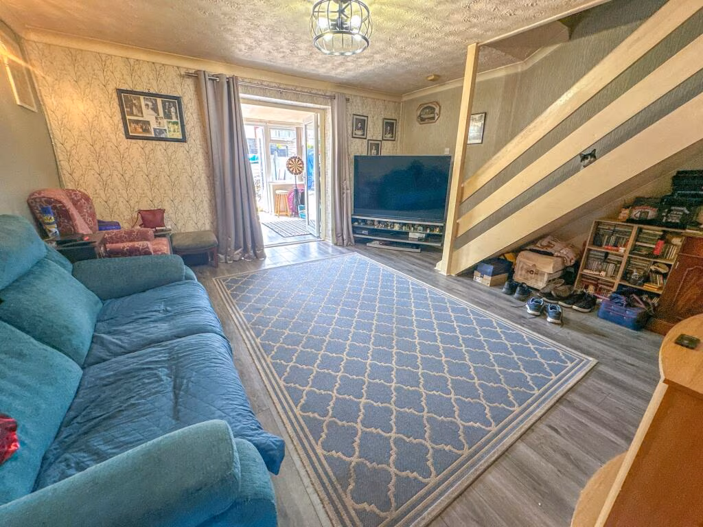
- living room modern
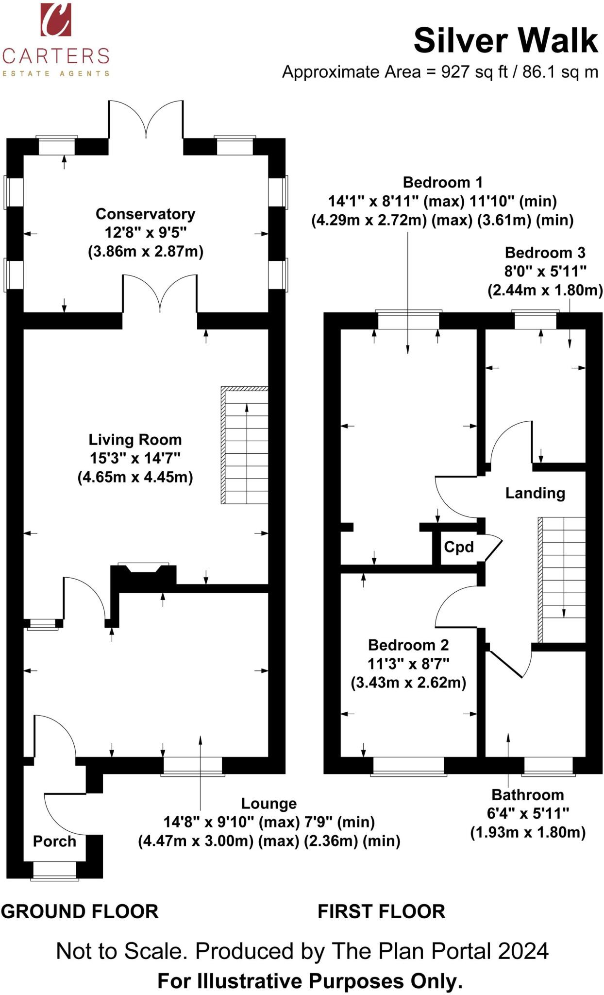
Floorplan Description
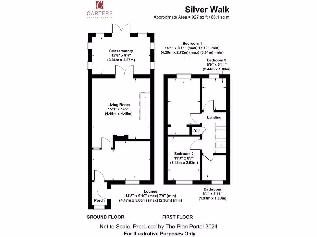
- A two-story property with multiple rooms including conservatory and bedrooms.
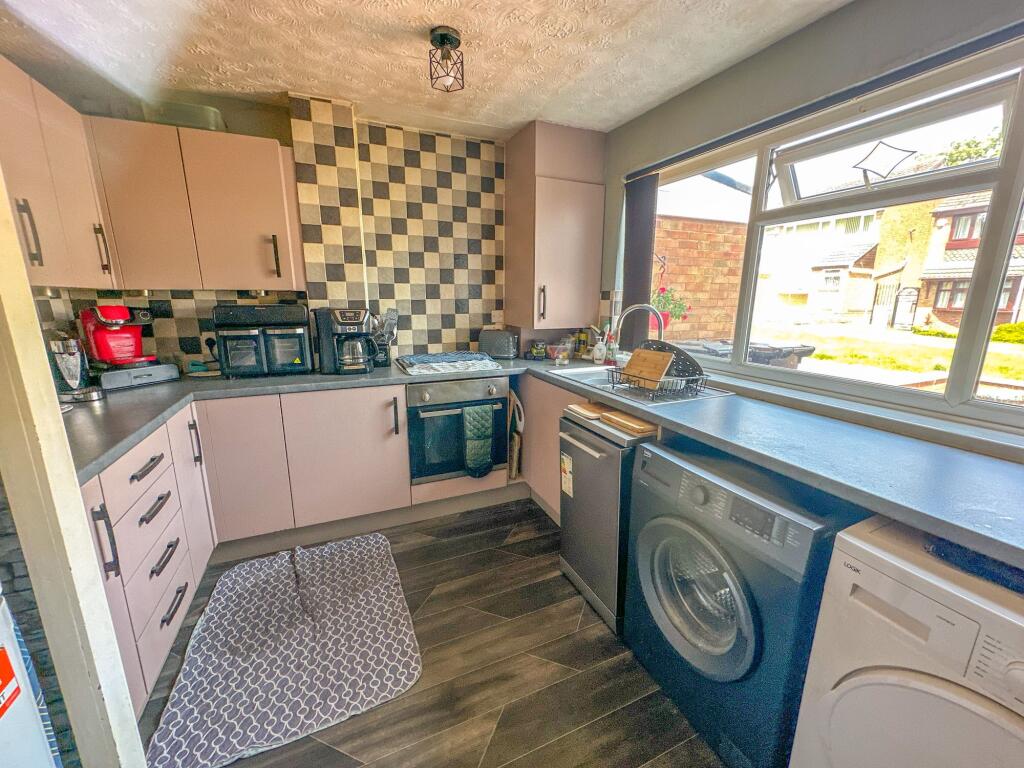
Rooms
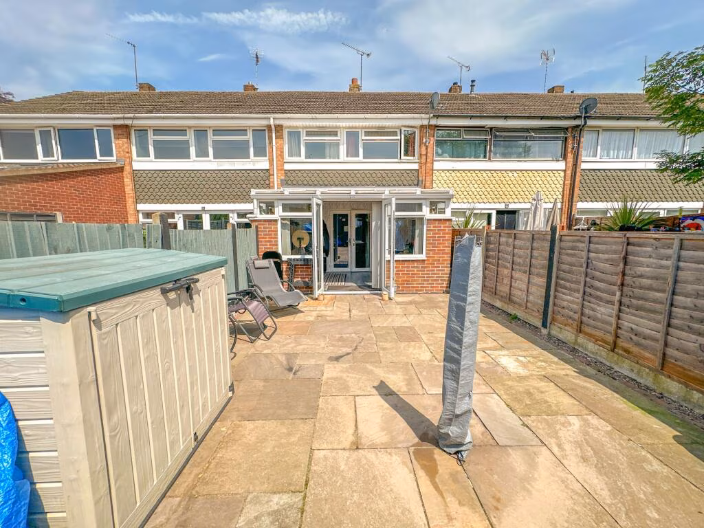
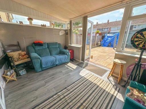
- Conservatory:
- Living Room:
- Lounge:
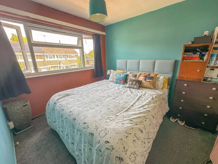
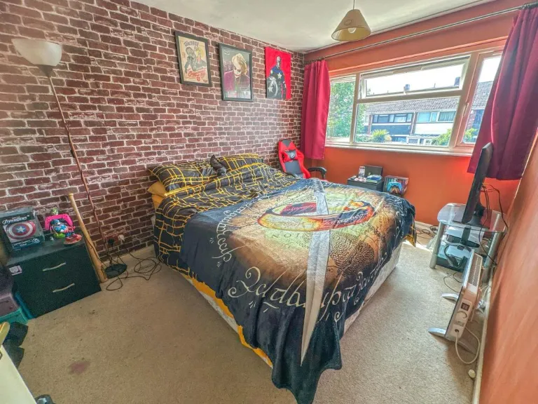
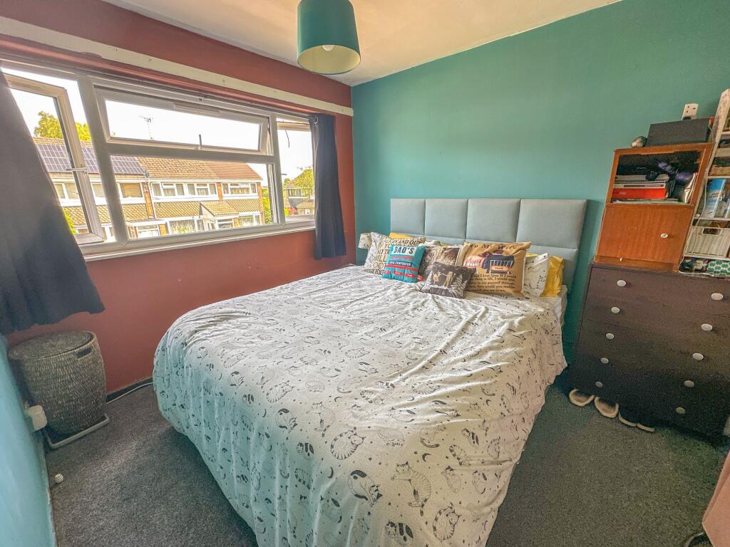
- Bedroom 1:
- Bedroom 2:
- Bedroom 3:
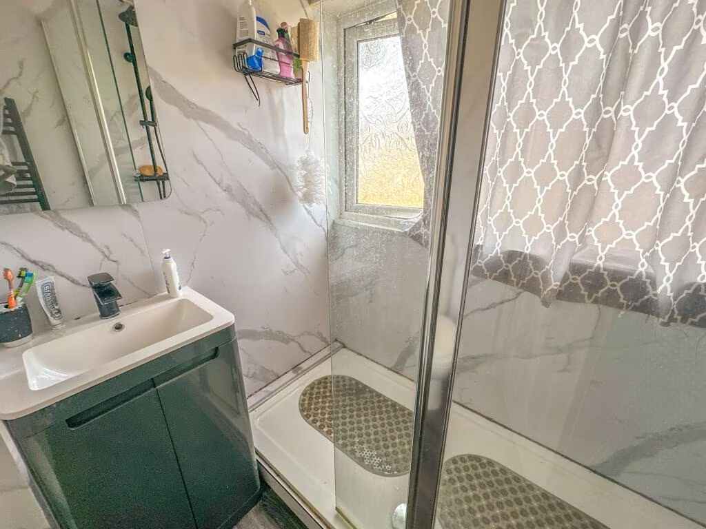
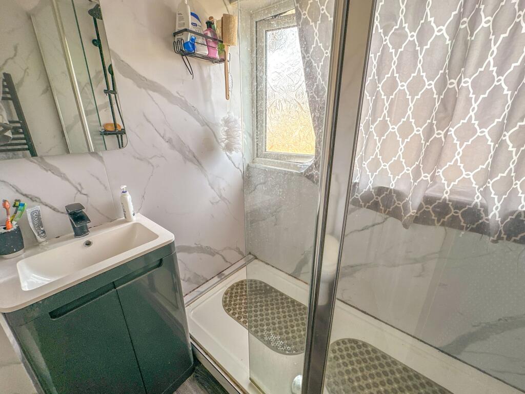
- Bathroom:
Textual Property Features
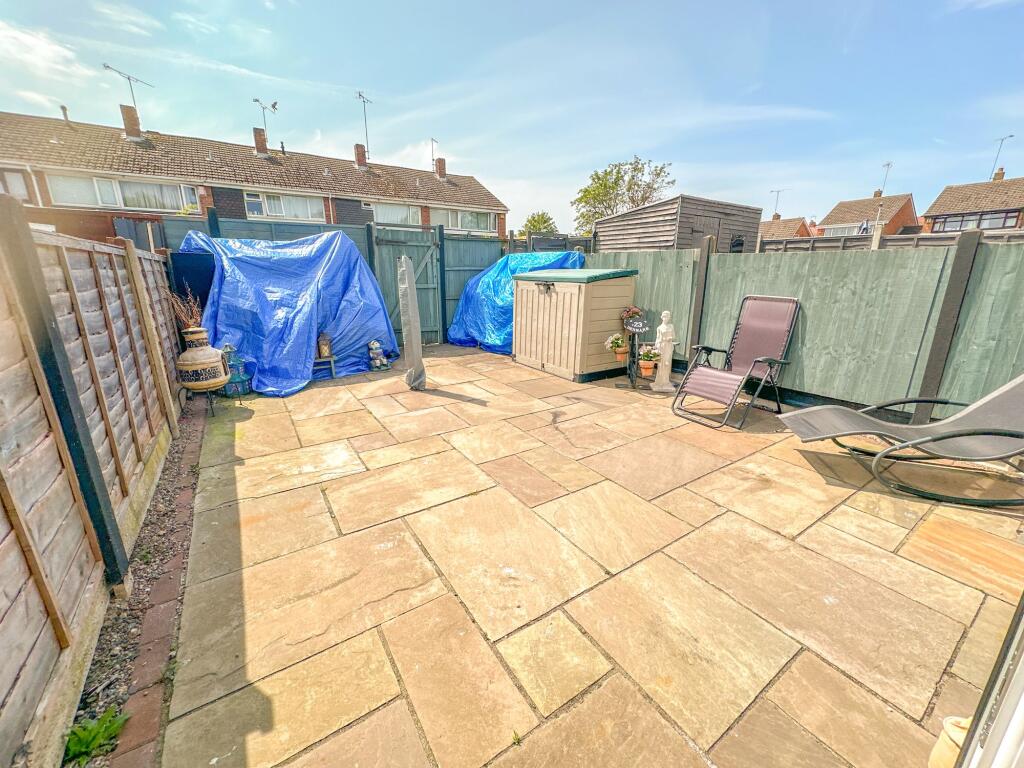
- Has Garden
- Chain Free
- Success
Detected Visual Features
- terraced house
- mid-20th century
- brick exterior
- composite roof
- paved front yard
- residential
- suburban
- investment potential
- retro
- needs modernization
- modern
- living room
- feature wall
- staircase
- natural light
- laminate flooring
- open plan
EPC Details
- Fully double glazed
- Cavity wall, as built, no insulation (assumed)
- Room heaters, electric
- Low energy lighting in 89% of fixed outlets
- Solid, no insulation (assumed)
Nearby Schools
- Middlemarch School
- Glendale Infant School
- Queen's Church of England Academy
- Higham Lane School
- Race Leys Infant School
- Race Leys Junior School
- Nuneaton Academy
- Nathaniel Newton Infant School
- Hartshill Academy
- Chilvers Coton Community Infant School
- Croft Junior School
- Abbey CofE Infant School
- Camp Hill Primary School
- Lower Farm Academy
- St Paul's CofE Primary School, Nuneaton
- George Eliot Academy
- All Saints CofE Primary School and Nursery, Nuneaton
- Wembrook Primary School
- Our Lady & St. Joseph Catholic Academy
- The Canons C of E Primary School
- Stockingford Academy
- St Anne's Catholic Academy
- St Thomas More Catholic School and Sixth Form College
- Etone College
- Weddington Primary School
- St Francis Catholic Academy
Nearest Bars And Restaurants
- Id: 2244683132
- Tags:
- Amenity: pub
- Name: The Griff And Coton
- TagsNormalized:
- Lat: 52.5143828
- Lon: -1.4767139
- FullGeoHash: gcqfwruwqn6r
- PartitionGeoHash: gcqf
- Images:
- FoodStandards: null
- Distance: 752.8
,- Id: 519128322
- Tags:
- Amenity: pub
- Landuse: retail
- Name: The Cock & Bear
- Source: GPS Survey
- TagsNormalized:
- Lat: 52.5228563
- Lon: -1.4827982
- FullGeoHash: gcqfy32rb619
- PartitionGeoHash: gcqf
- Images:
- FoodStandards: null
- Distance: 606.9
,- Id: 567920067
- Tags:
- Amenity: pub
- Building: yes
- Name: Hare & Hounds
- TagsNormalized:
- Lat: 52.5133711
- Lon: -1.4844941
- FullGeoHash: gcqfwpz08cbu
- PartitionGeoHash: gcqf
- Images:
- FoodStandards: null
- Distance: 510.4
,- Id: 3369954096
- Tags:
- Amenity: fast_food
- Name: Golden Fryer
- Name:en: Golden Fryer
- TagsNormalized:
- Lat: 52.5216862
- Lon: -1.4845496
- FullGeoHash: gcqfy1qbzrzt
- PartitionGeoHash: gcqf
- Images:
- FoodStandards: null
- Distance: 444.8
,- Id: 585577901
- Tags:
- Amenity: pub
- Building: pub
- Name: The Sunnyside
- Operator: John Barras
- Source: Warwicks CC Aerial Imagery 2013
- TagsNormalized:
- Lat: 52.5195398
- Lon: -1.4911367
- FullGeoHash: gcqfy0fhmzzf
- PartitionGeoHash: gcqf
- Images:
- FoodStandards: null
- Distance: 379.1
}
Nearest General Shops
- Id: 4791451032
- Tags:
- Name: Jewson
- Name:en: Jewson
- Shop: car_repair
- TagsNormalized:
- jewson
- car repair
- repair
- shop
- Lat: 52.5211177
- Lon: -1.4843472
- FullGeoHash: gcqfy1pjsjyw
- PartitionGeoHash: gcqf
- Images:
- FoodStandards: null
- Distance: 388.6
,- Id: 4805510523
- Tags:
- Name: Style Hair Arts
- Name:en: Style Hair Arts
- Shop: hairdresser
- TagsNormalized:
- Lat: 52.5194057
- Lon: -1.4862316
- FullGeoHash: gcqfy0vg8qc6
- PartitionGeoHash: gcqf
- Images:
- FoodStandards: null
- Distance: 175.4
,- Id: 4791474422
- Tags:
- Name: Inspired
- Shop: beauty
- TagsNormalized:
- Lat: 52.5193107
- Lon: -1.4863345
- FullGeoHash: gcqfy0vejvhe
- PartitionGeoHash: gcqf
- Images:
- FoodStandards: null
- Distance: 164.8
}
Nearest Grocery shops
- Id: 3369954060
- Tags:
- Name: Ram Newsagents
- Name:en: Ram Newsagents
- Shop: convenience
- TagsNormalized:
- Lat: 52.5216128
- Lon: -1.4844155
- FullGeoHash: gcqfy1r0dd78
- PartitionGeoHash: gcqf
- Images:
- FoodStandards: null
- Distance: 439.5
,- Id: 4791451023
- Tags:
- Name: Carling Drinks Corner
- Name:en: Carling Drinks Corner
- Shop: convenience
- TagsNormalized:
- Lat: 52.5213765
- Lon: -1.4870587
- FullGeoHash: gcqfy1jpjn0w
- PartitionGeoHash: gcqf
- Images:
- FoodStandards: null
- Distance: 397.9
,- Id: 166696479
- Tags:
- Brand: Tesco Express
- Brand:wikidata: Q98456772
- Brand:wikipedia: en:Tesco
- Building: retail
- Contact:
- Website: https://www.tesco.com/store-locator/nuneaton/240-croft-rd
- Name: Tesco Express
- Shop: convenience
- TagsNormalized:
- tesco
- tesco express
- retail
- convenience
- shop
- Lat: 52.5169739
- Lon: -1.4902022
- FullGeoHash: gcqfy06vec2x
- PartitionGeoHash: gcqf
- Images:
- FoodStandards: null
- Distance: 281.2
}
Nearest Supermarkets
- Id: 154900831
- Tags:
- Addr:
- Postcode: CV11 4XS
- Street: Vicarage Street
- Brand: Sainsbury's
- Brand:wikidata: Q152096
- Brand:wikipedia: en:Sainsbury's
- Building: yes
- Designation: Nuneaton Superstore
- Name: Sainsbury's
- Shop: supermarket
- Source: visual survey;bing
- Wheelchair: yes
- TagsNormalized:
- sainsburys
- supermarket
- shop
- Lat: 52.5200212
- Lon: -1.4637443
- FullGeoHash: gcqfy8ypk391
- PartitionGeoHash: gcqf
- Images:
- FoodStandards: null
- Distance: 1544.9
,- Id: 358085061
- Tags:
- Brand: Co-op Food
- Brand:wikidata: Q3277439
- Brand:wikipedia: en:Co-op Food
- Building: yes
- Name: Co-op Food
- Operator: The Co-operative Group
- Operator:wikidata: Q117202
- Shop: supermarket
- TagsNormalized:
- co-op
- co-op food
- food
- supermarket
- shop
- Lat: 52.5230836
- Lon: -1.4708591
- FullGeoHash: gcqfy98cnkrv
- PartitionGeoHash: gcqf
- Images:
- FoodStandards: null
- Distance: 1196.5
,- Id: 256981764
- Tags:
- Addr:
- Country: GB
- Postcode: CV11 5LD
- Street: Queen's Road
- Brand: Lidl
- Brand:wikidata: Q151954
- Brand:wikipedia: en:Lidl
- Building: yes
- Designation: Nuneaton
- Fhrs:
- Name: Lidl
- Shop: supermarket
- TagsNormalized:
- Lat: 52.5225135
- Lon: -1.4746137
- FullGeoHash: gcqfy3qjz40k
- PartitionGeoHash: gcqf
- Images:
- FoodStandards:
- Id: 638714
- FHRSID: 638714
- LocalAuthorityBusinessID: 92453
- BusinessName: Lidl
- BusinessType: Retailers - supermarkets/hypermarkets
- BusinessTypeID: 7840
- AddressLine1: Lidl
- AddressLine2: Queens Road
- AddressLine3: null
- AddressLine4: Nuneaton
- PostCode: CV11 5LD
- RatingValue: 5
- RatingKey: fhrs_5_en-GB
- RatingDate: 2022-05-24
- LocalAuthorityCode: 318
- LocalAuthorityName: Nuneaton and Bedworth
- LocalAuthorityWebSite: http://www.nuneatonandbedworth.gov.uk
- LocalAuthorityEmailAddress: food.team@nuneatonandbedworth.gov.uk
- Scores:
- Hygiene: 0
- Structural: 5
- ConfidenceInManagement: 5
- NewRatingPending: false
- Geocode:
- Longitude: null
- Latitude: null
- Distance: 946.3
}
Nearest Religious buildings
- Id: 847403491
- Tags:
- Amenity: place_of_worship
- Name: Fife Street Free Methodist Church
- Religion: christian
- Source: GPS Survey
- TagsNormalized:
- place of worship
- church
- methodist
- christian
- Lat: 52.5236414
- Lon: -1.4797816
- FullGeoHash: gcqfy3dkqs6v
- PartitionGeoHash: gcqf
- Images:
- FoodStandards: null
- Distance: 782.1
,- Id: 462774240
- Tags:
- Amenity: place_of_worship
- Building: yes
- Name: Heath End Church
- Religion: christian
- TagsNormalized:
- place of worship
- church
- heath
- christian
- Lat: 52.512795
- Lon: -1.4822852
- FullGeoHash: gcqfwr8thq2p
- PartitionGeoHash: gcqf
- Images:
- FoodStandards: null
- Distance: 621.9
,- Id: 155298147
- Tags:
- Addr:
- Amenity: school
- Name: Queens Church Of England Academy
- Ref:
- Source: bing
- Source:addr:postcode: get-information-schools.service.gov.uk
- TagsNormalized:
- Lat: 52.5221833
- Lon: -1.4814371
- FullGeoHash: gcqfy337bh87
- PartitionGeoHash: gcqf
- Images:
- FoodStandards: null
- Distance: 585.1
}
Nearest Medical buildings
- Id: 1033599131
- Tags:
- Amenity: hospital
- Healthcare: hospital
- Name: George Eliot Hospital
- Source: visual survey;estimate
- Wikidata: Q5538950
- TagsNormalized:
- Lat: 52.5116237
- Lon: -1.4759239
- FullGeoHash: gcqfwrmq2kpk
- PartitionGeoHash: gcqf
- Images:
- FoodStandards: null
- Distance: 984
,- Id: 166696856
- Tags:
- Amenity: doctors
- Emergency: no
- Healthcare: doctor
- TagsNormalized:
- doctor
- doctors
- health
- healthcare
- Lat: 52.5162836
- Lon: -1.4985712
- FullGeoHash: gcqfvbkc8bb6
- PartitionGeoHash: gcqf
- Images:
- FoodStandards: null
- Distance: 848.5
,- Id: 4805510521
- Tags:
- Amenity: pharmacy
- Brand: Lloyds Pharmacy
- Brand:wikidata: Q6662870
- Brand:wikipedia: en:LloydsPharmacy
- Healthcare: pharmacy
- Name: Lloyds Pharmacy
- Name:en: Lloyds Pharmacy
- TagsNormalized:
- pharmacy
- lloyds pharmacy
- health
- healthcare
- Lat: 52.5221229
- Lon: -1.4759432
- FullGeoHash: gcqfy3m7812f
- PartitionGeoHash: gcqf
- Images:
- FoodStandards: null
- Distance: 847.4
,- Id: 582991535
- Tags:
- Amenity: doctors
- Building: yes
- Healthcare: doctor
- Name: Stockingford Medical Centre
- Name:en: Stockingford Medical Centre
- Source: Warwicks CC Aerial Imagery 2013
- TagsNormalized:
- doctor
- doctors
- health
- healthcare
- Lat: 52.5209245
- Lon: -1.4935506
- FullGeoHash: gcqfy10kt9zy
- PartitionGeoHash: gcqf
- Images:
- FoodStandards: null
- Distance: 599.8
}
Nearest Airports
- Id: 2437117
- Tags:
- Aerodrome: international
- Aerodrome:type: public
- Aeroway: aerodrome
- Ele: 104
- Iata: BHX
- Icao: EGBB
- Internet_access: wlan
- Is_in: Birmingham,England,UK
- Name: Birmingham Airport
- Ref: BHX
- Type: multipolygon
- Website: https://www.birminghamairport.co.uk/
- Wikidata: Q8719
- Wikipedia: en:Birmingham Airport
- TagsNormalized:
- airport
- international airport
- Lat: 52.4543817
- Lon: -1.7468974
- FullGeoHash: gcqf2jpbym6y
- PartitionGeoHash: gcqf
- Images:
- FoodStandards: null
- Distance: 19004.4
}
Nearest Leisure Facilities
- Id: 330037328
- Tags:
- Leisure: playground
- Name: Jubilee Playground
- TagsNormalized:
- Lat: 52.5177847
- Lon: -1.4827122
- FullGeoHash: gcqfy286629s
- PartitionGeoHash: gcqf
- Images:
- FoodStandards: null
- Distance: 242.2
,- Id: 462679731
- Tags:
- Hoops: 1
- Leisure: pitch
- Sport: basketball
- Surface: paved
- TagsNormalized:
- pitch
- leisure
- basketball
- sports
- Lat: 52.5175617
- Lon: -1.4831677
- FullGeoHash: gcqfy0xbzxn4
- PartitionGeoHash: gcqf
- Images:
- FoodStandards: null
- Distance: 213.4
,- Id: 462679741
- Tags:
- Leisure: pitch
- Sport: soccer
- Surface: ground
- TagsNormalized:
- Lat: 52.5181388
- Lon: -1.483322
- FullGeoHash: gcqfy0xuk4du
- PartitionGeoHash: gcqf
- Images:
- FoodStandards: null
- Distance: 203.8
,- Id: 462679742
- Tags:
- Leisure: pitch
- Sport: soccer
- Surface: ground
- TagsNormalized:
- Lat: 52.5171256
- Lon: -1.4836742
- FullGeoHash: gcqfy0rw7vu2
- PartitionGeoHash: gcqf
- Images:
- FoodStandards: null
- Distance: 193.6
,- Id: 462679743
- Tags:
- Leisure: pitch
- Name: Jubilee Cricket Pitch
- Sport: cricket
- TagsNormalized:
- pitch
- leisure
- cricket
- sports
- Lat: 52.5176888
- Lon: -1.4841768
- FullGeoHash: gcqfy0x38nv8
- PartitionGeoHash: gcqf
- Images:
- FoodStandards: null
- Distance: 143.9
}
Nearest Tourist attractions
- Id: 218616482
- Tags:
- Name: Griff Caravan Site
- Tourism: caravan_site
- TagsNormalized:
- Lat: 52.5005371
- Lon: -1.4696575
- FullGeoHash: gcqfwt3vf3ry
- PartitionGeoHash: gcqf
- Images:
- FoodStandards: null
- Distance: 2228
,- Id: 148117471
- Tags:
- Building: yes
- Name: Nuneaton Museum and Art Gallery
- Source: survey; Bing
- Tourism: museum
- Wikidata: Q7069802
- TagsNormalized:
- Lat: 52.5202243
- Lon: -1.4660584
- FullGeoHash: gcqfy9h2qr7t
- PartitionGeoHash: gcqf
- Images:
- FoodStandards: null
- Distance: 1394.6
,- Id: 4791466023
- Tags:
- Name: Manor Court Care Home
- Name:en: Manor Court Care Home
- Tourism: hostel
- TagsNormalized:
- Lat: 52.525423
- Lon: -1.4786984
- FullGeoHash: gcqfy3gnzbd8
- PartitionGeoHash: gcqf
- Images:
- FoodStandards: null
- Distance: 988.4
}
Nearest Hotels
- Id: 463491876
- Tags:
- Brand: Travelodge
- Brand:wikidata: Q9361374
- Brand:wikipedia: en:Travelodge UK
- Building: yes
- Internet_access: wlan
- Internet_access:fee: customers
- Internet_access:ssid: Travelodge WiFi
- Name: Travelodge
- Tourism: hotel
- TagsNormalized:
- Lat: 52.5086334
- Lon: -1.4741625
- FullGeoHash: gcqfwqyscw8y
- PartitionGeoHash: gcqf
- Images:
- FoodStandards: null
- Distance: 1311.1
,- Id: 725984159
- Tags:
- Area: yes
- Building: yes
- Name: The Manor Hotel
- Tourism: hotel
- TagsNormalized:
- Lat: 52.5273887
- Lon: -1.4761689
- FullGeoHash: gcqfy6m44ybw
- PartitionGeoHash: gcqf
- Images:
- FoodStandards: null
- Distance: 1264.5
,- Id: 520746709
- Tags:
- Building: residential
- Name: Abbey Grange Hotel
- Source: Bing
- Tourism: hotel
- TagsNormalized:
- Lat: 52.5248879
- Lon: -1.4784149
- FullGeoHash: gcqfy3g7wkvb
- PartitionGeoHash: gcqf
- Images:
- FoodStandards: null
- Distance: 948.7
}
Tags
- terraced house
- mid-20th century
- brick exterior
- composite roof
- paved front yard
- residential
- suburban
- investment potential
- retro
- needs modernization
- modern
- living room
- feature wall
- staircase
- natural light
- laminate flooring
- open plan
Local Market Stats
- Average Price/sqft: £230
- Avg Income: £41500
- Rental Yield: 5%
- Social Housing: 10%
- Planning Success Rate: 93%
AirBnB Data
- 1km average: £75/night
- Listings in 1km: 1
Similar Properties
 3 bedroom property for sale in Rutland Avenue, Nuneaton, CV10 — £195,000 • 3 bed • 1 bath • 843 ft²
 3 bedroom terraced house for sale in Eadie Street, Nuneaton, CV10 — £165,000 • 3 bed • 1 bath
 3 bedroom terraced house for sale in Kingswood Road, Nuneaton, CV10 — £169,950 • 3 bed • 1 bath • 926 ft²
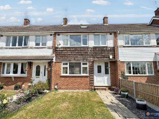 3 bedroom terraced house for sale in Granby Road, Stockingford, Nuneaton, CV10 8EL, CV10 — £210,000 • 3 bed • 1 bath • 1130 ft²
 3 bedroom semi-detached house for sale in Raynor Crescent, Bedworth, CV12 — £170,000 • 3 bed • 1 bath • 802 ft²
 3 bedroom terraced house for sale in Westbury Road, Nuneaton, Warwickshire, CV10 — £165,000 • 3 bed • 1 bath • 915 ft²
Meta
- {
"@context": "https://schema.org",
"@type": "Residence",
"name": "3 bedroom terraced house for sale in Silver Walk, Nuneaton,…",
"description": "",
"url": "https://propertypiper.co.uk/property/52c8e855-0e73-4101-a949-5e0e08147602",
"image": "https://image-a.propertypiper.co.uk/1ed214b6-ba7e-4cf4-8e57-94c1734a6a23-1024.jpeg",
"address": {
"@type": "PostalAddress",
"streetAddress": "47 SILVER WALK NUNEATON ",
"postalCode": "CV10 7LZ",
"addressLocality": "Nuneaton and Bedworth",
"addressRegion": "Nuneaton",
"addressCountry": "England"
},
"geo": {
"@type": "GeoCoordinates",
"latitude": 52.517828890444605,
"longitude": -1.4862907764016224
},
"numberOfRooms": 3,
"numberOfBathroomsTotal": 1,
"floorSize": {
"@type": "QuantitativeValue",
"value": 635,
"unitCode": "FTK"
},
"offers": {
"@type": "Offer",
"price": 194950,
"priceCurrency": "GBP",
"availability": "https://schema.org/InStock"
},
"additionalProperty": [
{
"@type": "PropertyValue",
"name": "Feature",
"value": "terraced house"
},
{
"@type": "PropertyValue",
"name": "Feature",
"value": "mid-20th century"
},
{
"@type": "PropertyValue",
"name": "Feature",
"value": "brick exterior"
},
{
"@type": "PropertyValue",
"name": "Feature",
"value": "composite roof"
},
{
"@type": "PropertyValue",
"name": "Feature",
"value": "paved front yard"
},
{
"@type": "PropertyValue",
"name": "Feature",
"value": "residential"
},
{
"@type": "PropertyValue",
"name": "Feature",
"value": "suburban"
},
{
"@type": "PropertyValue",
"name": "Feature",
"value": "investment potential"
},
{
"@type": "PropertyValue",
"name": "Feature",
"value": "retro"
},
{
"@type": "PropertyValue",
"name": "Feature",
"value": "needs modernization"
},
{
"@type": "PropertyValue",
"name": "Feature",
"value": "modern"
},
{
"@type": "PropertyValue",
"name": "Feature",
"value": "living room"
},
{
"@type": "PropertyValue",
"name": "Feature",
"value": "feature wall"
},
{
"@type": "PropertyValue",
"name": "Feature",
"value": "staircase"
},
{
"@type": "PropertyValue",
"name": "Feature",
"value": "natural light"
},
{
"@type": "PropertyValue",
"name": "Feature",
"value": "laminate flooring"
},
{
"@type": "PropertyValue",
"name": "Feature",
"value": "open plan"
}
]
}
High Res Floorplan Images
Compatible Floorplan Images
FloorplanImages Thumbnail