BS23 4PR - 2 bedroom flat for sale in Ottawa Road, WestonSuperMare, BS…
View on Property Piper
2 bedroom flat for sale in Ottawa Road, Weston-Super-Mare, BS23
Property Details
- Price: £50000
- Bedrooms: 2
- Bathrooms: 1
- Property Type: undefined
- Property SubType: undefined
Brochure Descriptions
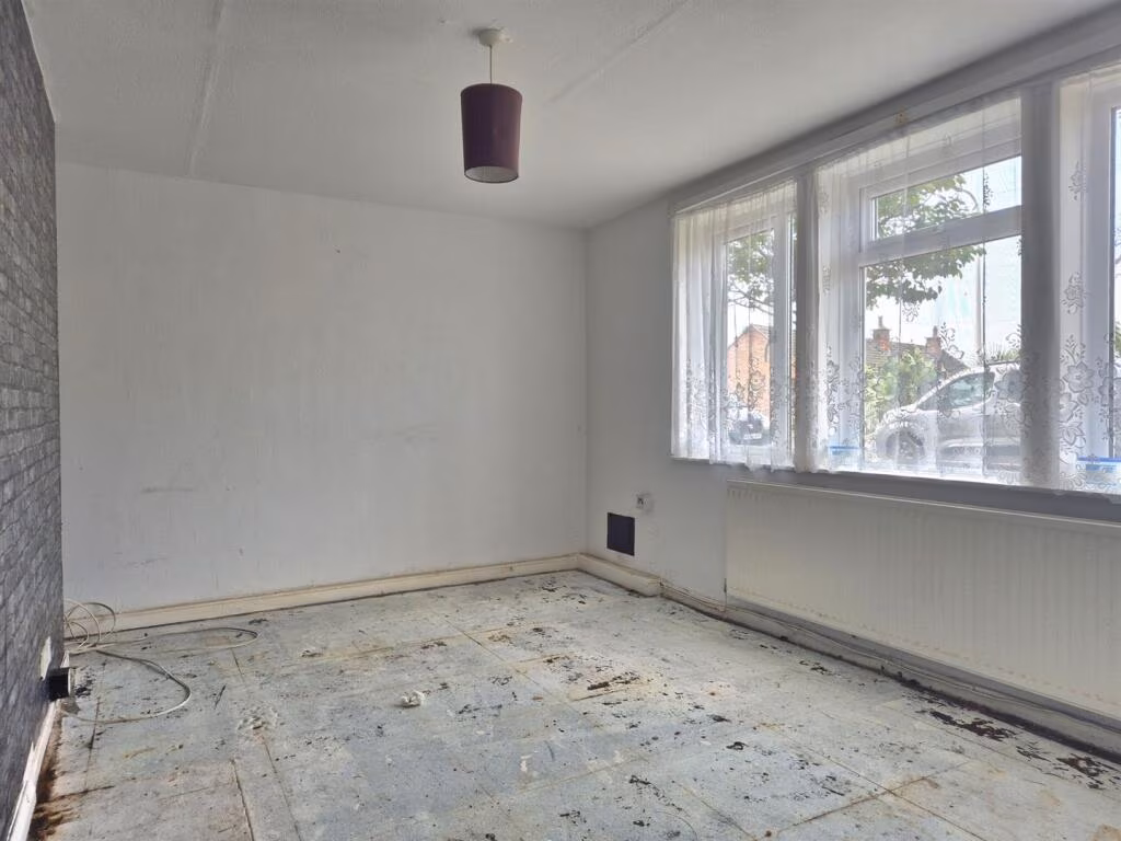
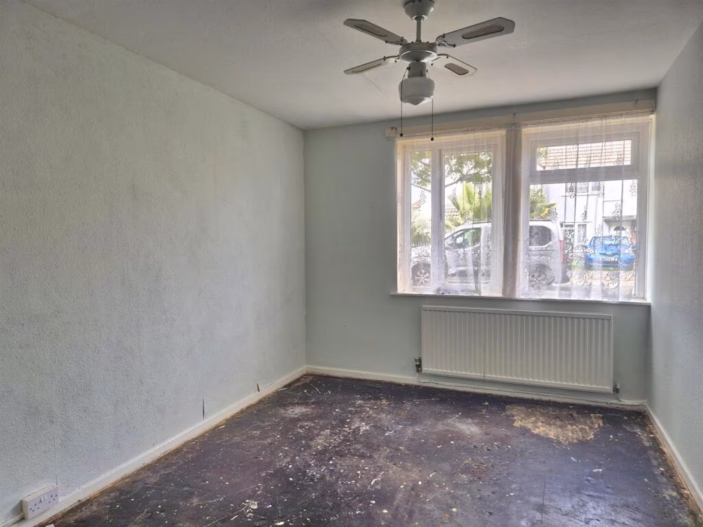
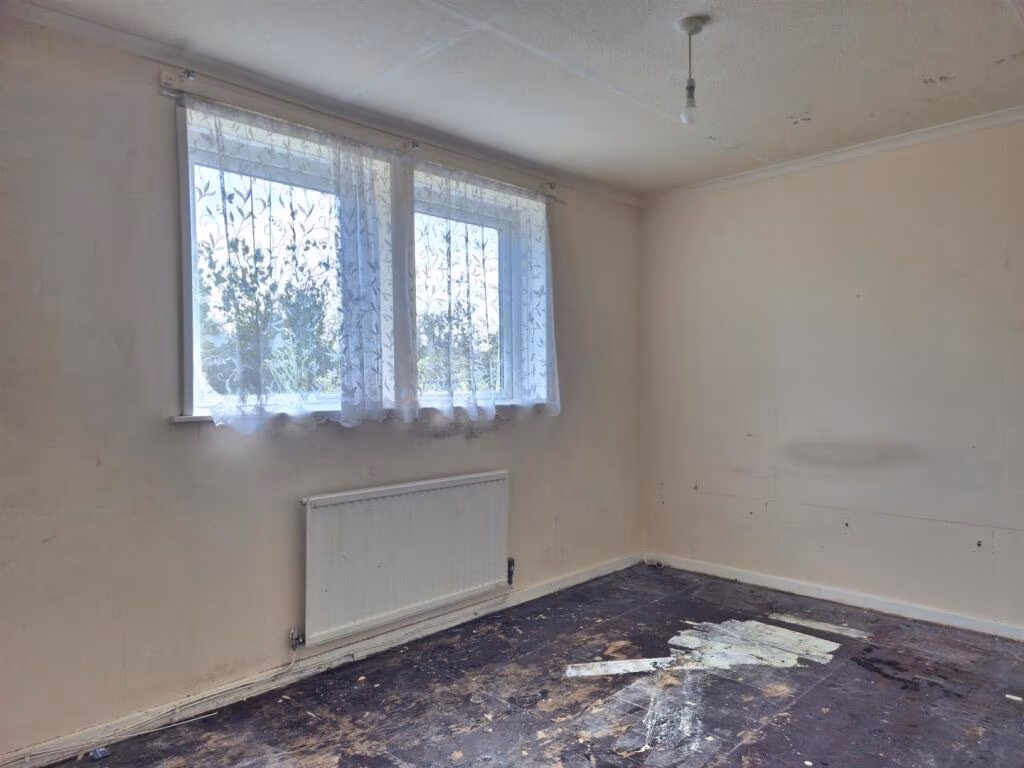
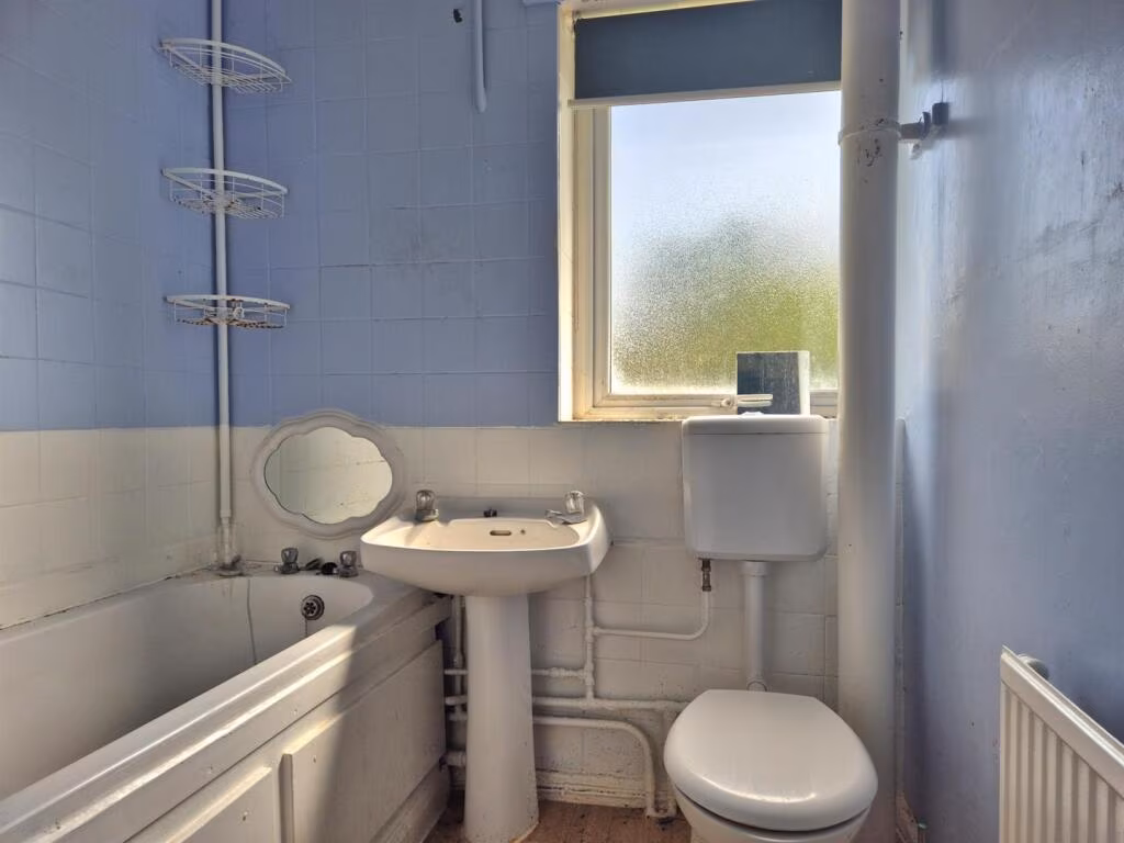
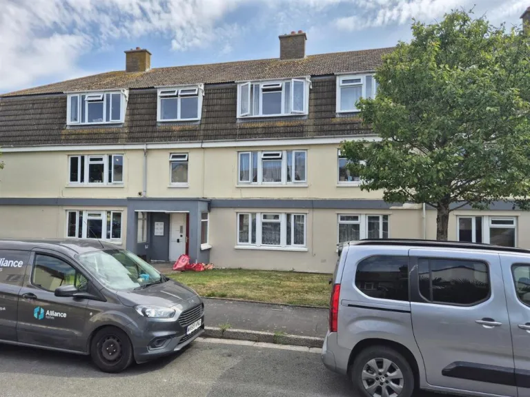
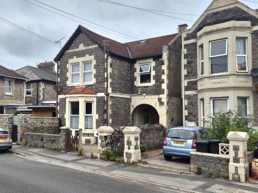
- The property is a mid-terrace townhouse over three floors, featuring a pitched roof with dormer windows on the top floor. The frontage includes a small garden area and the overall property size is average for a townhouse. The external appearance suggests a post-war construction, rendered with light-colored finish. The garden size to the front is small and there is off-road parking available. The property fronts a residential street and the view is of similar residential housing and some greenery. There are no exceptional views visible (e.g., sea or river).
Image Descriptions
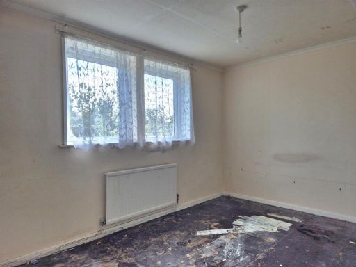
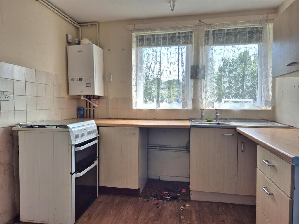
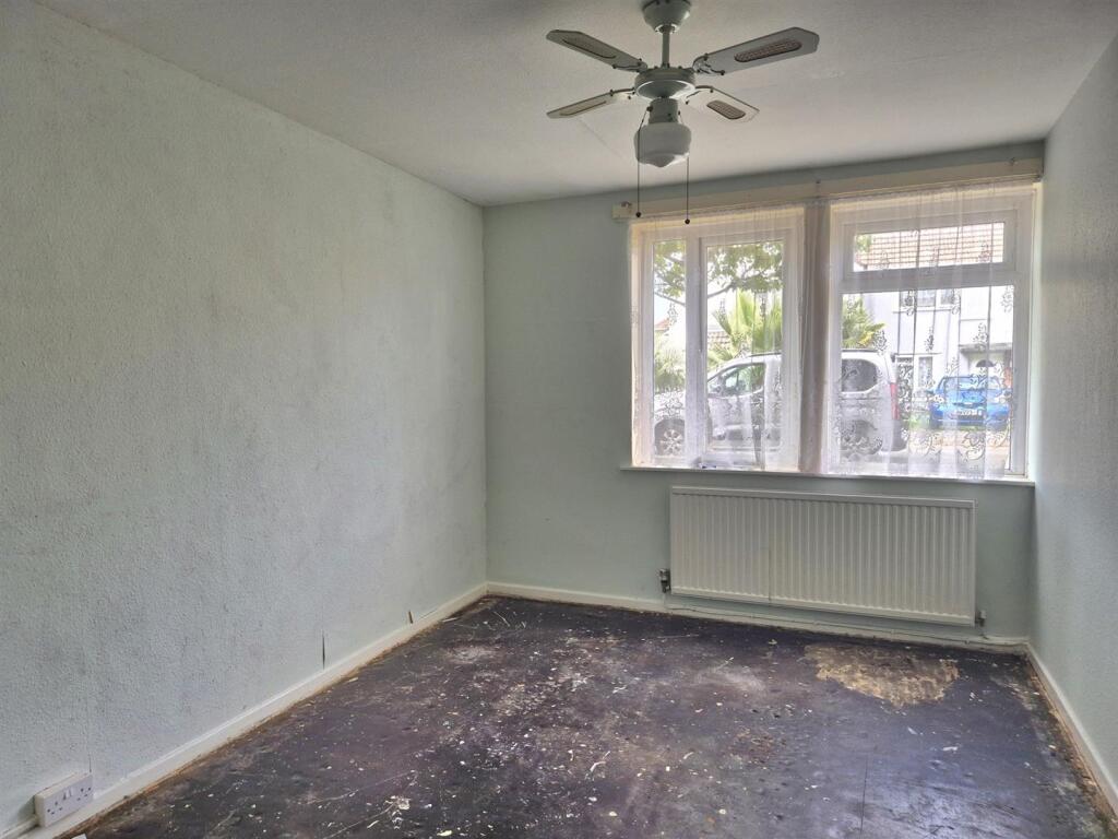
- apartment block mid-20th century
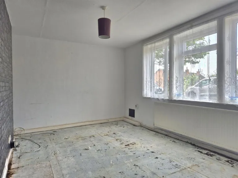
- living room mid-20th century
Floorplan Description
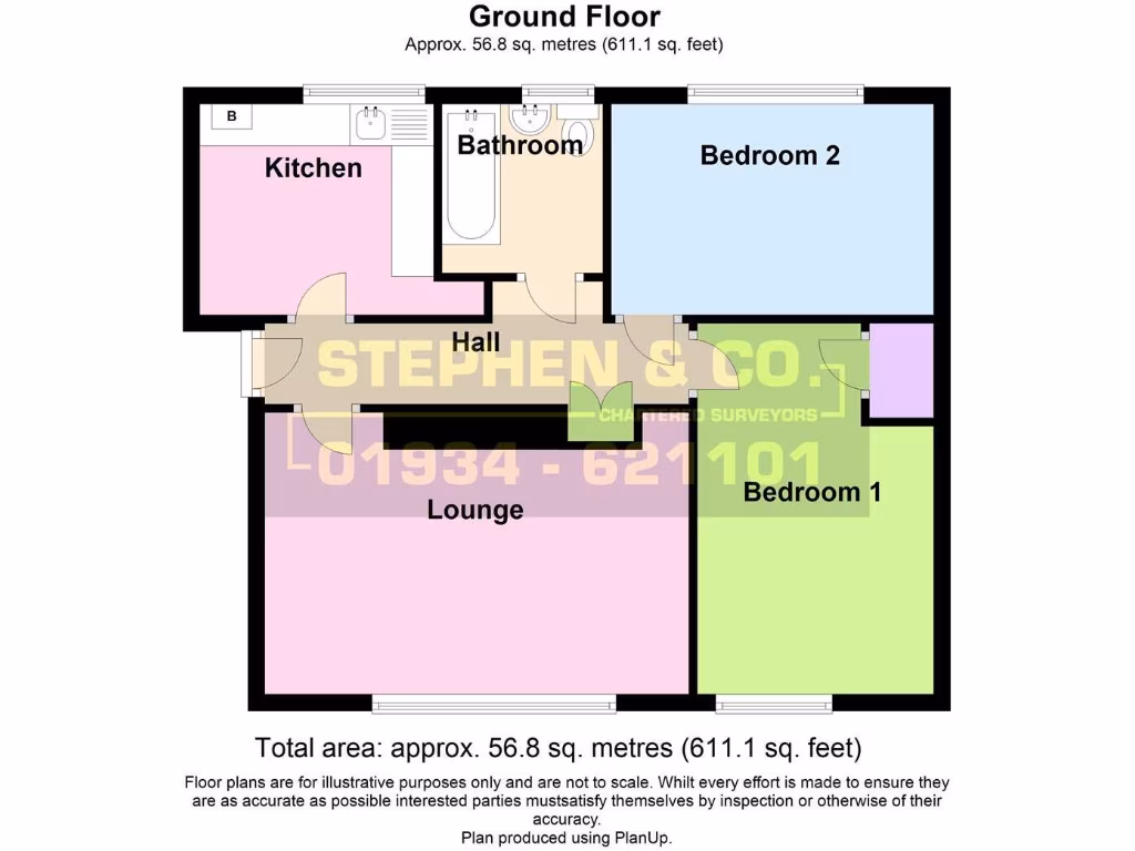
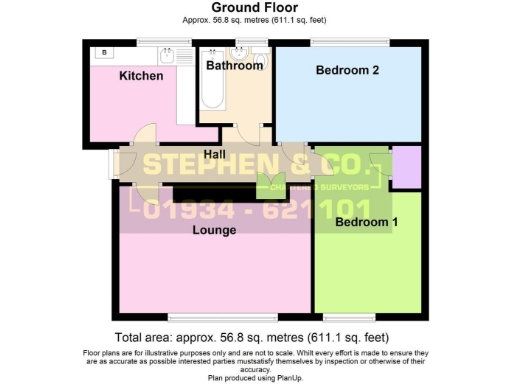
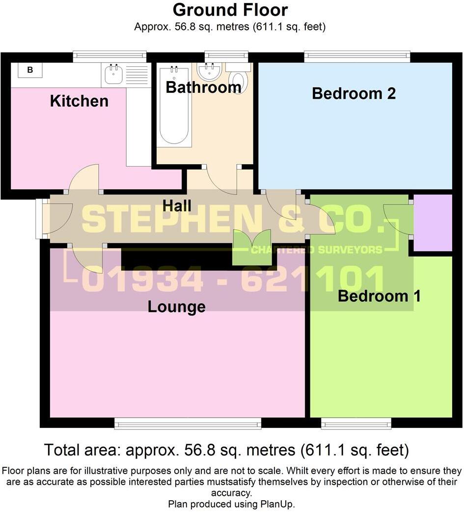
- A 611.1 square feet property with a kitchen, bathroom, two bedrooms, a hall, and a lounge.
Rooms
- Kitchen:
- Bathroom:
- Bedroom 2:
- Hall:
- Lounge:
- Bedroom 1:
Textual Property Features
- Is Public Notice
- Is Auction
- Is Ex Local Authority
- Success
Detected Visual Features
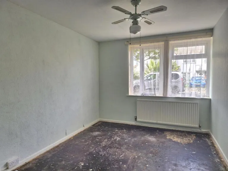
- apartment
- flat
- mid-20th century
- exterior
- residential
- gabled roof
- communal
- minimalist
- basic
- functional
- fixer-upper
- dated
- needs renovation
- unfinished flooring
- basic windows
- radiator heating
- mid-century
- potential
- natural light
EPC Details
- Fully double glazed
- System built, with external insulation
- Boiler and radiators, mains gas
- Low energy lighting in all fixed outlets
- Solid, no insulation (assumed)
Nearby Schools
- Lympsham Church of England Academy
- Hutton Church of England Primary School
- Walliscote Primary School
- Worle Community School
- Mendip Green Primary School
- St Martin's Church of England Primary School
- Oldmixon Primary School
- Uphill Village Academy
- Broadoak Academy
- Windwhistle Primary School
- Bournville Primary School
- Winterstoke Hundred Academy
- Ashcombe Primary School
- Christ Church Church of England Primary School
- Mead Vale Community Primary School
- Milton Park Primary School
- Worle Village Primary School
- Kewstoke Primary School
- Locking Primary School
- Parklands Educate Together Primary
- Haywood Village Academy
- Hans Price Academy
- Corpus Christi Catholic Primary School
- Herons' Moor Academy
- Worlebury St Pauls Church School
- St Mark's Ecumenical Anglican/Methodist Primary School
Nearest General Shops
- Id: 1130986706
- Tags:
- Addr:
- Name: Roché Hairdressers
- Shop: hairdresser
- TagsNormalized:
- Lat: 51.3338392
- Lon: -2.9764165
- FullGeoHash: gcjuh309k3ny
- PartitionGeoHash: gcju
- Images:
- FoodStandards: null
- Distance: 882
,- Id: 3099632425
- Tags:
- Addr:
- Postcode: BS24 9AA
- Street: Winterstoke Road
- Name: Feature Fire
- Note: sells stoves, fires, fireplaces, firewood etc
- Shop: trade
- Trade: fire
- Website: http://www.feature-fire.co.uk/
- TagsNormalized:
- Lat: 51.3320663
- Lon: -2.9565804
- FullGeoHash: gcjuh8xnfwty
- PartitionGeoHash: gcju
- Images:
- FoodStandards: null
- Distance: 791.6
,- Id: 4823866158
- Tags:
- Brand: Proper Job
- Brand:wikidata: Q83741810
- Name: Proper Job
- Shop: hardware
- Source: Survey
- TagsNormalized:
- Lat: 51.3338301
- Lon: -2.9722969
- FullGeoHash: gcjuh359hrwb
- PartitionGeoHash: gcju
- Images:
- FoodStandards: null
- Distance: 686.3
}
Nearest Religious buildings
- Id: 1130986746
- Tags:
- Amenity: place_of_worship
- TagsNormalized:
- Lat: 51.3336583
- Lon: -2.9784169
- FullGeoHash: gcjuh1p0jz7r
- PartitionGeoHash: gcju
- Images:
- FoodStandards: null
- Distance: 981.4
,- Id: 813698605
- Tags:
- Amenity: place_of_worship
- Building: church
- Denomination: anglican
- Name: St Nicholas
- Religion: christian
- Wikidata: Q26598511
- TagsNormalized:
- place of worship
- church
- anglican
- christian
- Lat: 51.3246221
- Lon: -2.9778971
- FullGeoHash: gcjgupre9gnb
- PartitionGeoHash: gcjg
- Images:
- FoodStandards: null
- Distance: 905.7
,- Id: 313023823
- Tags:
- Amenity: place_of_worship
- Building: church
- Denomination: anglican
- Name: St Barnabas Mission Church
- Religion: christian
- Source: Bing
- Wikidata: Q105091114
- TagsNormalized:
- place of worship
- church
- anglican
- christian
- Lat: 51.3253527
- Lon: -2.9665006
- FullGeoHash: gcjgurrzge0y
- PartitionGeoHash: gcjg
- Images:
- FoodStandards: null
- Distance: 378.9
}
Nearest Medical buildings
- Id: 98767385
- Tags:
- Amenity: hospital
- Building: yes
- Healthcare: hospital
- Source: OS_OpenData_StreetView
- TagsNormalized:
- Lat: 51.3392599
- Lon: -2.9688273
- FullGeoHash: gcjuh6n0v79y
- PartitionGeoHash: gcju
- Images:
- FoodStandards: null
- Distance: 1177.3
,- Id: 1130986736
- Tags:
- Addr:
- Amenity: pharmacy
- Healthcare: pharmacy
- Name: Shaws Pharmacy
- TagsNormalized:
- Lat: 51.3339264
- Lon: -2.9789432
- FullGeoHash: gcjuh1ncc96y
- PartitionGeoHash: gcju
- Images:
- FoodStandards: null
- Distance: 1028.3
,- Id: 854599317
- Tags:
- Addr:
- City: Weston-Super-Mare
- Postcode: BS23 4TQ
- Street: Grange Road
- Suburb: Uphill
- Amenity: hospital
- Emergency: yes
- Fhrs:
- Healthcare: hospital
- Name: Weston General Hospital
- Source:
- Wikidata: Q7989433
- TagsNormalized:
- hospital
- health
- healthcare
- general
- Lat: 51.3224266
- Lon: -2.9725604
- FullGeoHash: gcjguqgqy3dr
- PartitionGeoHash: gcjg
- Images:
- FoodStandards:
- Id: 581772
- FHRSID: 581772
- LocalAuthorityBusinessID: U07JWMGRAN/1
- BusinessName: Weston General Ward Kitchens
- BusinessType: Hospitals/Childcare/Caring Premises
- BusinessTypeID: 5
- AddressLine1: null
- AddressLine2: Grange Road
- AddressLine3: Uphill
- AddressLine4: Weston-Super-Mare
- PostCode: BS23 4TQ
- RatingValue: 5
- RatingKey: fhrs_5_en-GB
- RatingDate: 2022-02-28
- LocalAuthorityCode: 858
- LocalAuthorityName: North Somerset
- LocalAuthorityWebSite: http://www.n-somerset.gov.uk
- LocalAuthorityEmailAddress: foodandsafety@n-somerset.gov.uk
- Scores:
- Hygiene: 5
- Structural: 0
- ConfidenceInManagement: 5
- NewRatingPending: false
- Geocode:
- Longitude: -2.97141098976135
- Latitude: 51.32234191894530
- Distance: 814.4
,- Id: 813635585
- Tags:
- Addr:
- Amenity: community_centre
- Building: yes
- Name: The For All Healthy Living Centre
- Wikidata: Q55163604
- TagsNormalized:
- Lat: 51.3320996
- Lon: -2.9657655
- FullGeoHash: gcjuh88rhsuv
- PartitionGeoHash: gcju
- Images:
- FoodStandards: null
- Distance: 376.8
}
Nearest Airports
- Id: 47483196
- Tags:
- Aerodrome: international
- Aeroway: aerodrome
- Iata: BRS
- Icao: EGGD
- Internet_access: wlan
- Internet_access:fee: no
- Name: Bristol Airport
- Type: public
- Website: https://www.bristolairport.co.uk/
- Wikidata: Q8725
- Wikipedia: en:Bristol Airport
- TagsNormalized:
- airport
- international airport
- Lat: 51.3830799
- Lon: -2.7186615
- FullGeoHash: gcnh64h24s74
- PartitionGeoHash: gcnh
- Images:
- FoodStandards: null
- Distance: 18250
,- Id: 319112968
- Tags:
- Aerodrome: international
- Aerodrome:type: public
- Aeroway: aerodrome
- Iata: CWL
- Icao: EGFF
- Internet_access: yes
- Internet_access:fee: no
- Is_in: Cardiff,Wales,UK
- Name: Cardiff Airport
- Operator: Cardiff International Airport Limited
- Source: Gagravarr_Airports
- Type: civil
- Wikidata: Q8994
- Wikipedia: en:Cardiff Airport
- TagsNormalized:
- airport
- international airport
- Lat: 51.3978554
- Lon: -3.3438203
- FullGeoHash: gcjs7utn5qdy
- PartitionGeoHash: gcjs
- Images:
- FoodStandards: null
- Distance: 27288.7
}
Nearest Leisure Facilities
- Id: 960091408
- Tags:
- TagsNormalized:
- Lat: 51.3269497
- Lon: -2.9709562
- FullGeoHash: gcjguru95sym
- PartitionGeoHash: gcjg
- Images:
- FoodStandards: null
- Distance: 359.4
,- Id: 984909447
- Tags:
- Leisure: pitch
- Sport: cricket
- TagsNormalized:
- pitch
- leisure
- cricket
- sports
- Lat: 51.3292409
- Lon: -2.9716727
- FullGeoHash: gcjuh2hne000
- PartitionGeoHash: gcju
- Images:
- FoodStandards: null
- Distance: 351.8
,- Id: 120818584
- Tags:
- Leisure: pitch
- Sport: soccer
- TagsNormalized:
- Lat: 51.3275444
- Lon: -2.962432
- FullGeoHash: gcjguxfud7f8
- PartitionGeoHash: gcjg
- Images:
- FoodStandards: null
- Distance: 323.8
,- Id: 984909454
- Tags:
- TagsNormalized:
- Lat: 51.3298723
- Lon: -2.9662692
- FullGeoHash: gcjuh8240vtr
- PartitionGeoHash: gcju
- Images:
- FoodStandards: null
- Distance: 126.9
,- Id: 170856101
- Tags:
- TagsNormalized:
- Lat: 51.3279522
- Lon: -2.9677883
- FullGeoHash: gcjguryyvxb9
- PartitionGeoHash: gcjg
- Images:
- FoodStandards: null
- Distance: 118.7
}
Nearest Tourist attractions
- Id: 366848200
- Tags:
- Addr:
- City: Weston-Super-Mare
- Postcode: BS23 1BE
- Street: Marine Parade
- Amenity: arts_centre
- Name: Tropicana
- Old_name: Dismaland
- Tourism: attraction
- Wikidata: Q7846196
- TagsNormalized:
- arts centre
- attraction
- tourism
- Lat: 51.3407859
- Lon: -2.9826493
- FullGeoHash: gcjuh4k1g0pm
- PartitionGeoHash: gcju
- Images:
- FoodStandards: null
- Distance: 1738.2
,- Id: 125983962
- Tags:
- Source: Bing
- Tourism: caravan_site
- TagsNormalized:
- Lat: 51.3235378
- Lon: -2.9893491
- FullGeoHash: gcjggzpjr0gu
- PartitionGeoHash: gcjg
- Images:
- FoodStandards: null
- Distance: 1679.4
,- Id: 522781497
- Tags:
- Building: ruins
- Name: Explosives Store
- Source: GPS
- Tourism: attraction
- TagsNormalized:
- Lat: 51.3186717
- Lon: -2.9827506
- FullGeoHash: gcjgunk0bvgb
- PartitionGeoHash: gcjg
- Images:
- FoodStandards: null
- Distance: 1583.3
}
Nearest Train stations
- Id: 474564204
- Tags:
- Name: Highbridge and Burnham
- Naptan:
- Network: National Rail
- Public_transport: station
- Railway: station
- Ref:
- Wikidata: Q2508684
- Wikipedia: en:Highbridge and Burnham railway station
- TagsNormalized:
- Lat: 51.2183132
- Lon: -2.9720037
- FullGeoHash: gcjgkk5b7397
- PartitionGeoHash: gcjg
- Images:
- FoodStandards: null
- Distance: 12286.5
,- Id: 21277558
- Tags:
- Name: Yatton
- Naptan:
- Network: National Rail
- Operator: GWR
- Platforms: 2
- Public_transport: station
- Railway: station
- Ref:
- Source: NPE + GPX
- Wikidata: Q1957149
- Wikipedia: en:Yatton railway station
- TagsNormalized:
- Lat: 51.3908826
- Lon: -2.8277046
- FullGeoHash: gcjurekvtdye
- PartitionGeoHash: gcju
- Images:
- FoodStandards: null
- Distance: 11866.6
,- Id: 253893851
- Tags:
- Name: Worle
- Naptan:
- Network: National Rail
- Public_transport: station
- Railway: station
- Ref:
- Wikidata: Q2416797
- Wikipedia: en:Worle railway station
- TagsNormalized:
- Lat: 51.3578502
- Lon: -2.9093225
- FullGeoHash: gcjujv3mpv5v
- PartitionGeoHash: gcju
- Images:
- FoodStandards: null
- Distance: 5131.3
,- Id: 21277557
- Tags:
- Name: Weston Milton
- Naptan:
- Network: National Rail
- Operator: GWR
- Public_transport: station
- Railway: station
- Ref:
- Source: NPE + GPX
- Wikidata: Q2432877
- Wikipedia: en:Weston Milton railway station
- TagsNormalized:
- Lat: 51.3485177
- Lon: -2.9422803
- FullGeoHash: gcjuj59qzckz
- PartitionGeoHash: gcju
- Images:
- FoodStandards: null
- Distance: 2774.5
,- Id: 21277582
- Tags:
- Name: Weston-super-Mare
- Naptan:
- Network: National Rail
- Public_transport: station
- Railway: station
- Ref:
- Source: NPE
- Wikidata: Q2335883
- Wikipedia: en:Weston-super-Mare railway station
- TagsNormalized:
- Lat: 51.344496
- Lon: -2.9718305
- FullGeoHash: gcjuh6gzr7f8
- PartitionGeoHash: gcju
- Images:
- FoodStandards: null
- Distance: 1786.3
}
Nearest Hotels
- Id: 180578855
- Tags:
- Addr:
- City: Weston-Super-Mare
- Postcode: BS23 1TT
- Street: Dolphin Square
- Brand: Premier Inn
- Brand:wikidata: Q2108626
- Brand:wikipedia: en:Premier Inn
- Building: yes
- Building:levels: 4
- Fhrs:
- Internet_access: wlan
- Internet_access:fee: customers
- Internet_access:operator: Virgin Media
- Internet_access:ssid: Premier Inn Free Wi-Fi
- Name: Premier Inn
- Smoking: no
- Tourism: hotel
- TagsNormalized:
- Lat: 51.3452855
- Lon: -2.9800784
- FullGeoHash: gcjuh5jgznuq
- PartitionGeoHash: gcju
- Images:
- FoodStandards: null
- Distance: 2060.4
,- Id: 192553325
- Tags:
- Addr:
- City: Weston-Super-Mare
- Postcode: BS23 1BA
- Street: Beach Road
- Building: yes
- Fhrs:
- Name: The Grand Atlantic Hotel
- Source: Bing
- Source:name: survey
- Tourism: hotel
- TagsNormalized:
- Lat: 51.3438811
- Lon: -2.9798723
- FullGeoHash: gcjuh4y5gcnh
- PartitionGeoHash: gcju
- Images:
- FoodStandards: null
- Distance: 1915.5
,- Id: 98774087
- Tags:
- Building: yes
- Name: Uphill Manor
- Source: OS_OpenData_StreetView
- Tourism: hotel
- Wikidata: Q17534259
- TagsNormalized:
- Lat: 51.3260862
- Lon: -2.9786257
- FullGeoHash: gcjgupxh0gzw
- PartitionGeoHash: gcjg
- Images:
- FoodStandards: null
- Distance: 882.3
}
Tags
- apartment
- flat
- mid-20th century
- exterior
- residential
- gabled roof
- communal
- minimalist
- basic
- functional
- fixer-upper
- dated
- needs renovation
- unfinished flooring
- basic windows
- radiator heating
- mid-century
- potential
- natural light
Local Market Stats
- Average Price/sqft: £233
- Avg Income: £39400
- Rental Yield: 4.7%
- Social Housing: 15%
- Planning Success Rate: 83%
Similar Properties
 2 bedroom flat for sale in Clarendon Road, Weston-Super-Mare, BS23 — £80,000 • 2 bed • 1 bath • 637 ft²
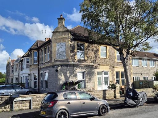 1 bedroom flat for sale in St. Pauls Road, Weston-Super-Mare, BS23 — £50,000 • 1 bed • 1 bath • 531 ft²
 3 bedroom block of apartments for sale in Weston-super-Mare*Studio Flat*First Floor Flat*Ground Floor Flat*, BS23 — £170,000 • 3 bed • 1 bath • 388 ft²
 2 bedroom flat for sale in Moorland Road, Weston-super-Mare, Somerset, BS23 — £110,000 • 2 bed • 1 bath • 708 ft²
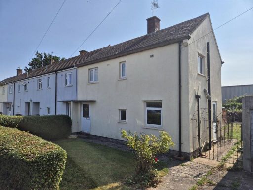 2 bedroom end of terrace house for sale in Coleridge Road, Weston-Super-Mare, BS23 — £130,000 • 2 bed • 1 bath • 905 ft²
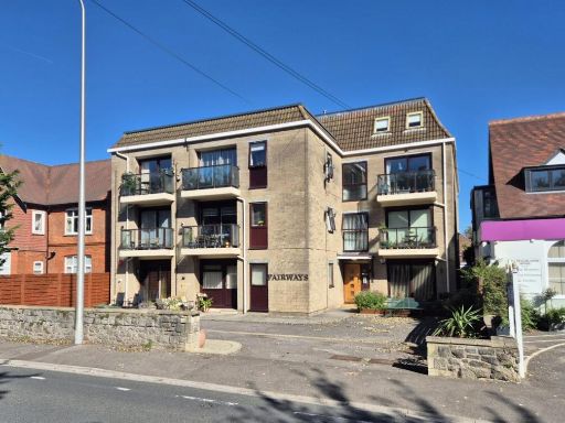 2 bedroom flat for sale in 15 Uphill Road North, Weston-Super-Mare, BS23 — £130,000 • 2 bed • 1 bath • 789 ft²
Meta
- {
"@context": "https://schema.org",
"@type": "Residence",
"name": "2 bedroom flat for sale in Ottawa Road, WestonSuperMare, BS…",
"description": "",
"url": "https://propertypiper.co.uk/property/434cc2ff-12ec-4630-a049-ef819ceff301",
"image": "https://image-a.propertypiper.co.uk/129307f8-72f1-4940-9246-6e888c3b3fbd-1024.jpeg",
"address": {
"@type": "PostalAddress",
"streetAddress": "43 OTTAWA ROAD WESTON-SUPER-MARE ",
"postalCode": "BS23 4PR",
"addressLocality": "North Somerset",
"addressRegion": "Weston-Super-Mare",
"addressCountry": "England"
},
"geo": {
"@type": "GeoCoordinates",
"latitude": 51.32875827262502,
"longitude": -2.9666687657966824
},
"numberOfRooms": 2,
"numberOfBathroomsTotal": 1,
"floorSize": {
"@type": "QuantitativeValue",
"value": 700,
"unitCode": "FTK"
},
"offers": {
"@type": "Offer",
"price": 50000,
"priceCurrency": "GBP",
"availability": "https://schema.org/InStock"
},
"additionalProperty": [
{
"@type": "PropertyValue",
"name": "Feature",
"value": "apartment"
},
{
"@type": "PropertyValue",
"name": "Feature",
"value": "flat"
},
{
"@type": "PropertyValue",
"name": "Feature",
"value": "mid-20th century"
},
{
"@type": "PropertyValue",
"name": "Feature",
"value": "exterior"
},
{
"@type": "PropertyValue",
"name": "Feature",
"value": "residential"
},
{
"@type": "PropertyValue",
"name": "Feature",
"value": "gabled roof"
},
{
"@type": "PropertyValue",
"name": "Feature",
"value": "communal"
},
{
"@type": "PropertyValue",
"name": "Feature",
"value": "minimalist"
},
{
"@type": "PropertyValue",
"name": "Feature",
"value": "basic"
},
{
"@type": "PropertyValue",
"name": "Feature",
"value": "functional"
},
{
"@type": "PropertyValue",
"name": "Feature",
"value": "fixer-upper"
},
{
"@type": "PropertyValue",
"name": "Feature",
"value": "dated"
},
{
"@type": "PropertyValue",
"name": "Feature",
"value": "needs renovation"
},
{
"@type": "PropertyValue",
"name": "Feature",
"value": "unfinished flooring"
},
{
"@type": "PropertyValue",
"name": "Feature",
"value": "basic windows"
},
{
"@type": "PropertyValue",
"name": "Feature",
"value": "radiator heating"
},
{
"@type": "PropertyValue",
"name": "Feature",
"value": "mid-century"
},
{
"@type": "PropertyValue",
"name": "Feature",
"value": "potential"
},
{
"@type": "PropertyValue",
"name": "Feature",
"value": "natural light"
}
]
}
High Res Floorplan Images
Compatible Floorplan Images
FloorplanImages Thumbnail