L16 2LZ - 3 bedroom semidetached house for sale in Court Hey Road, Ch…
View on Property Piper
3 bedroom semi-detached house for sale in Court Hey Road, Childwall, Liverpool, L16
Property Details
- Price: £335000
- Bedrooms: 3
- Bathrooms: 1
- Property Type: undefined
- Property SubType: undefined
Brochure Descriptions
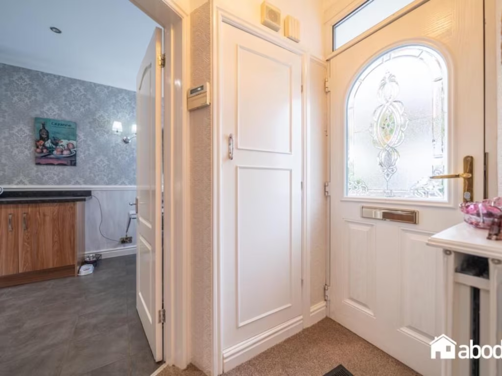
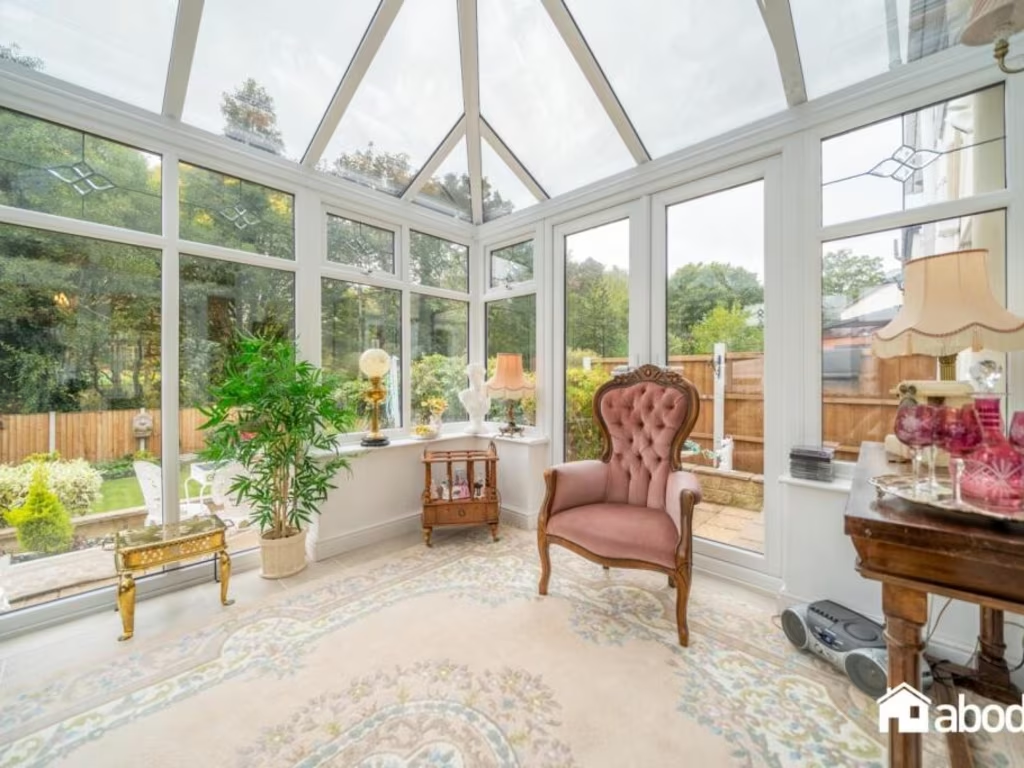
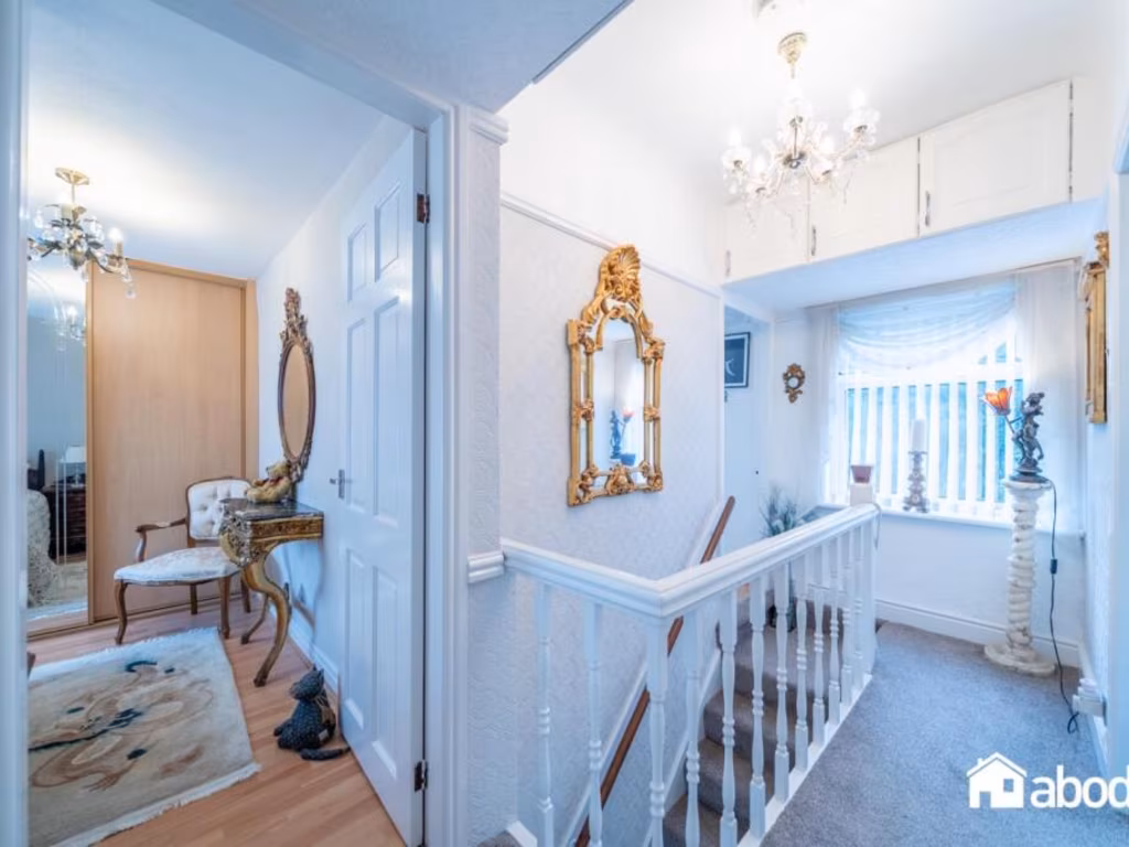
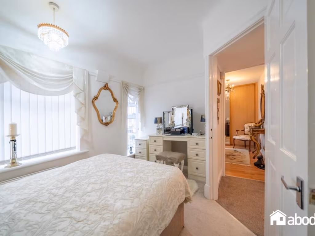
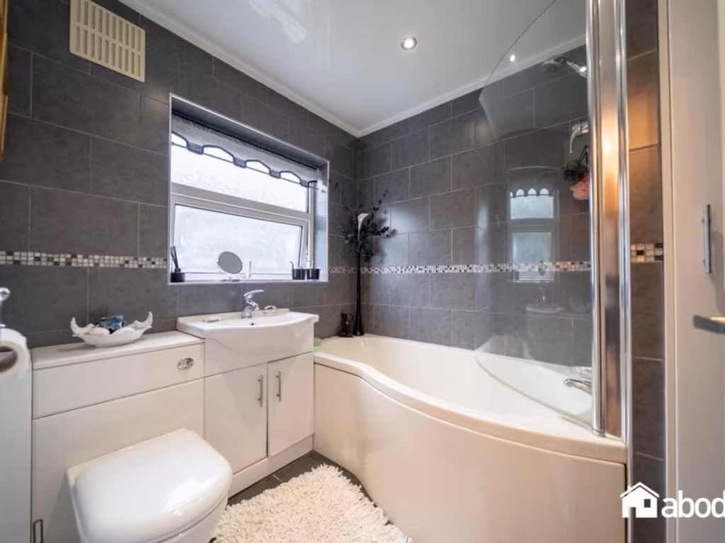
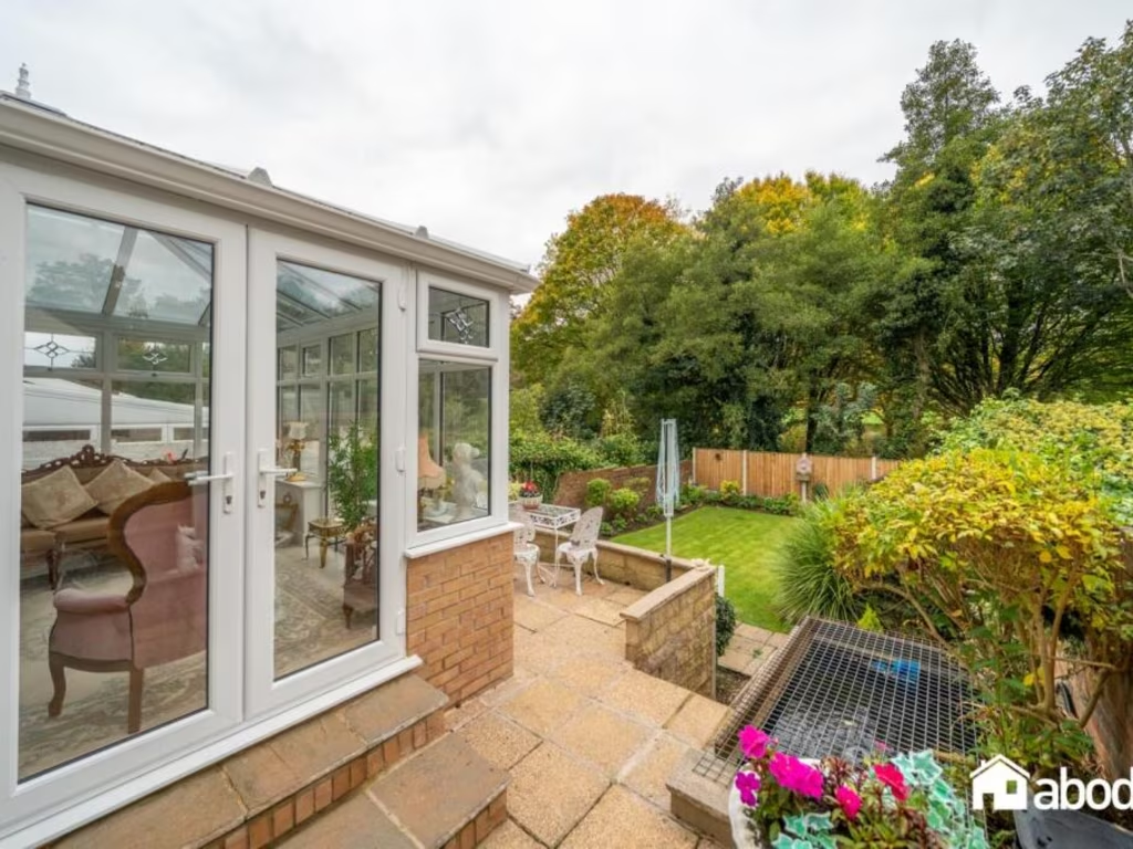
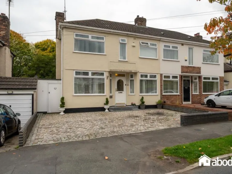
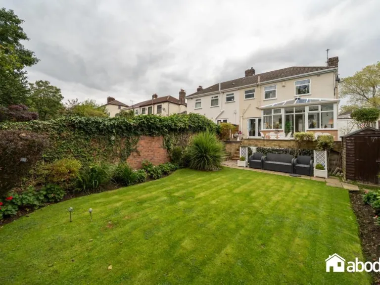
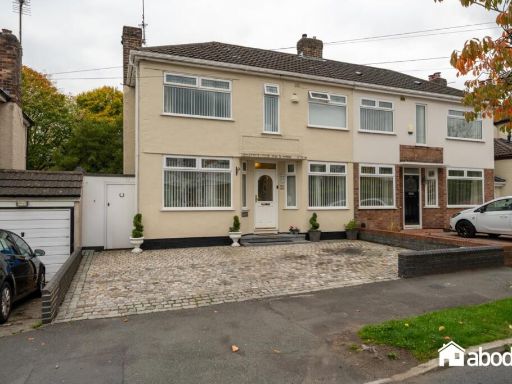
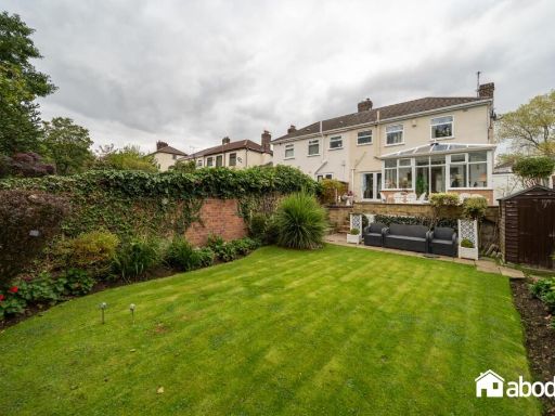
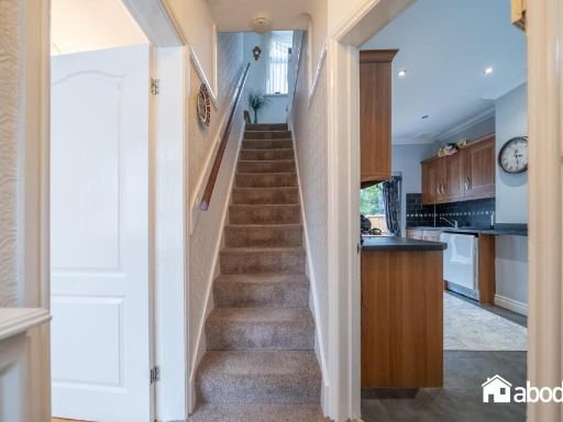
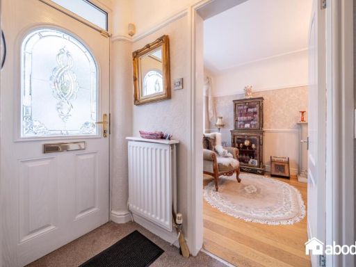
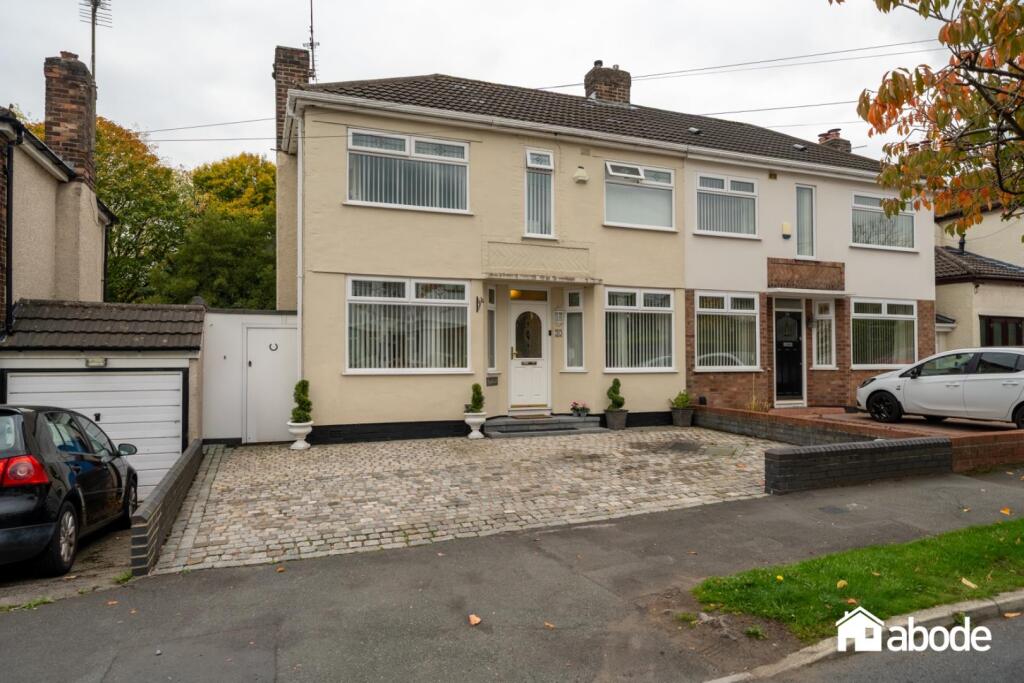
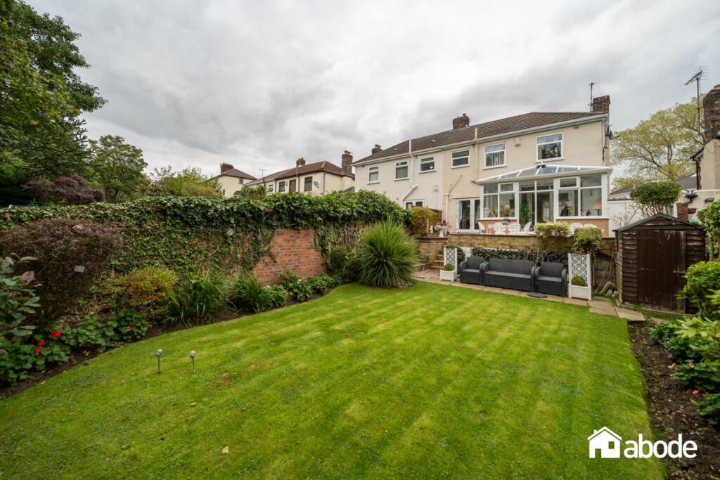
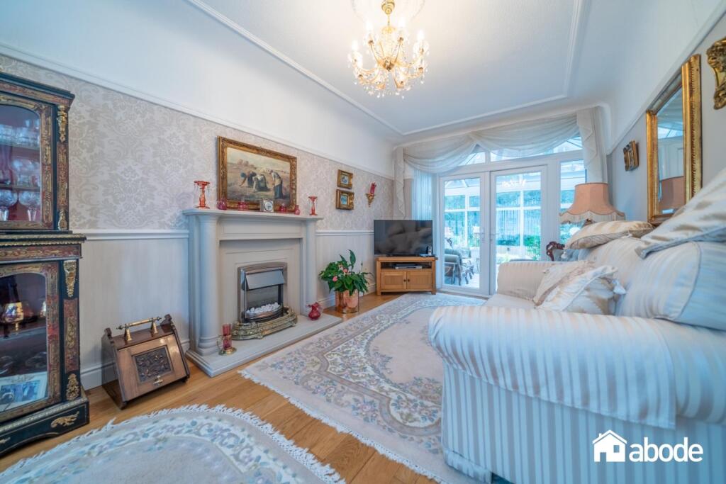
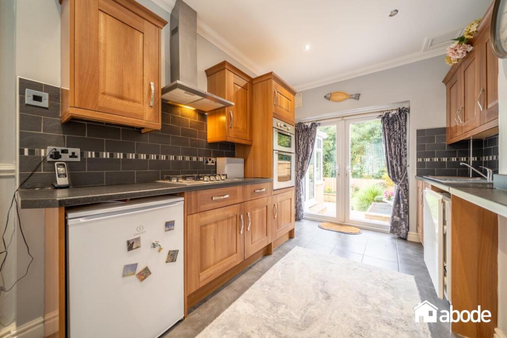
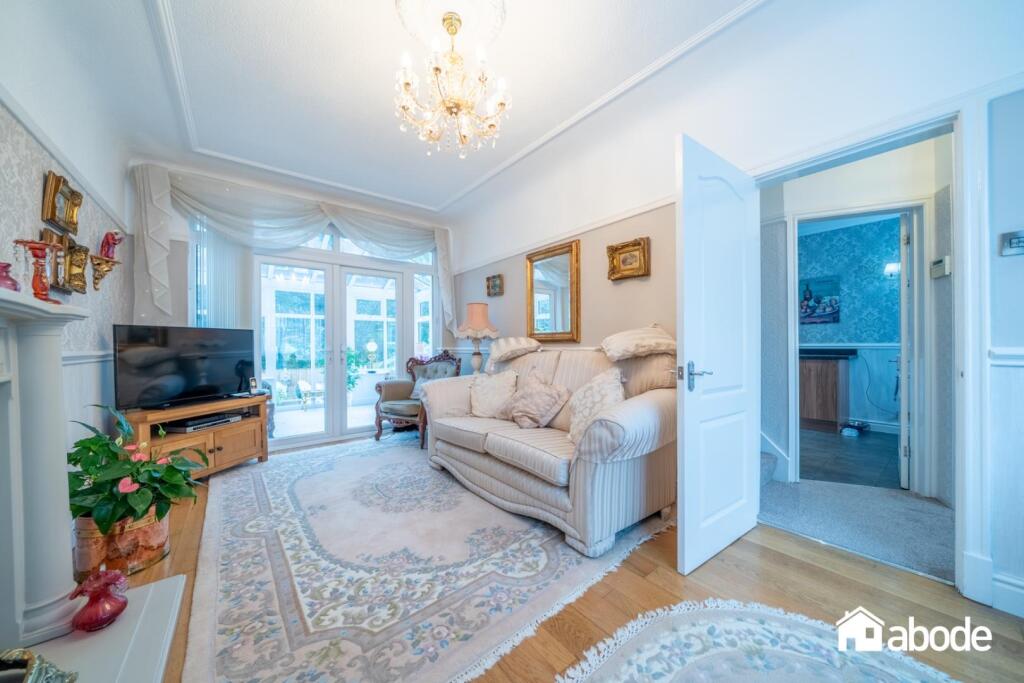
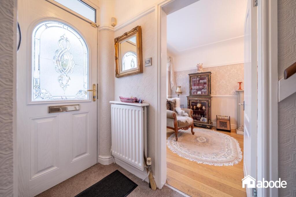
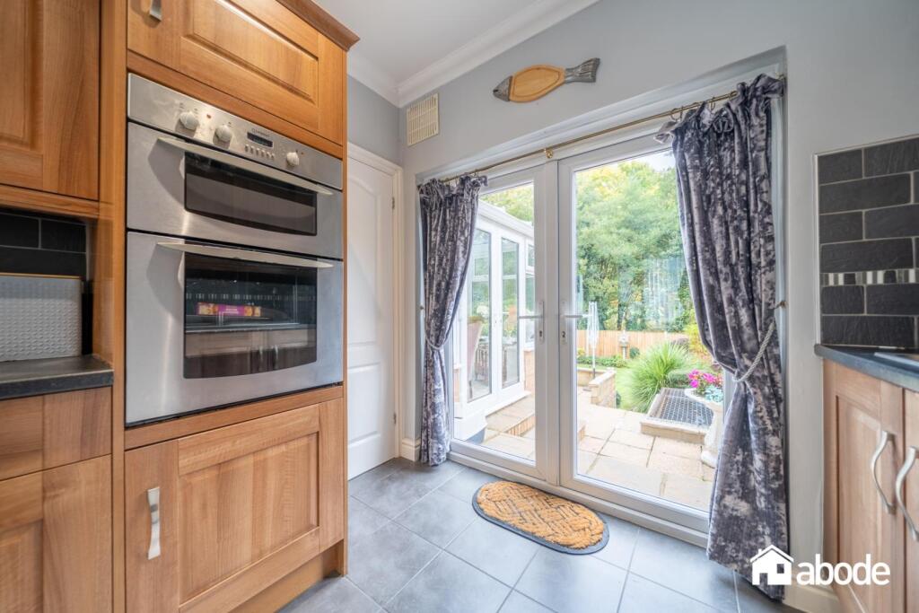
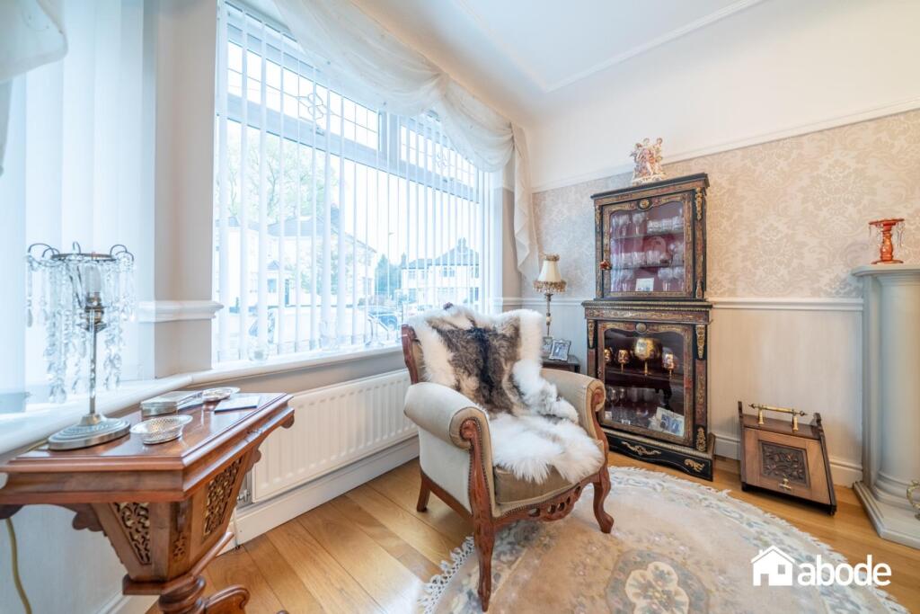
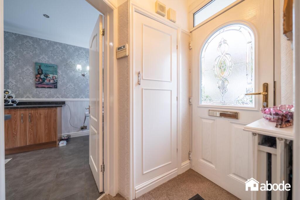
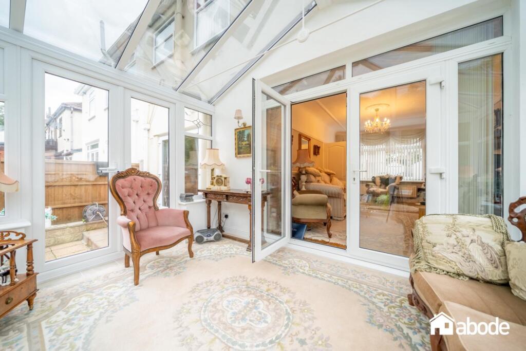
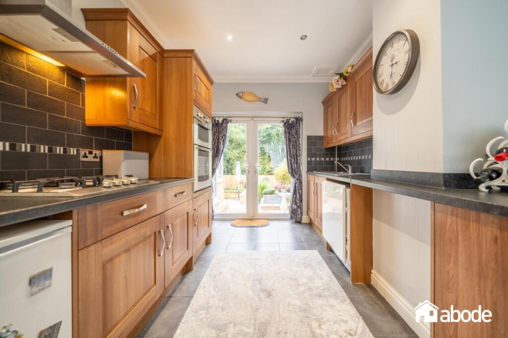
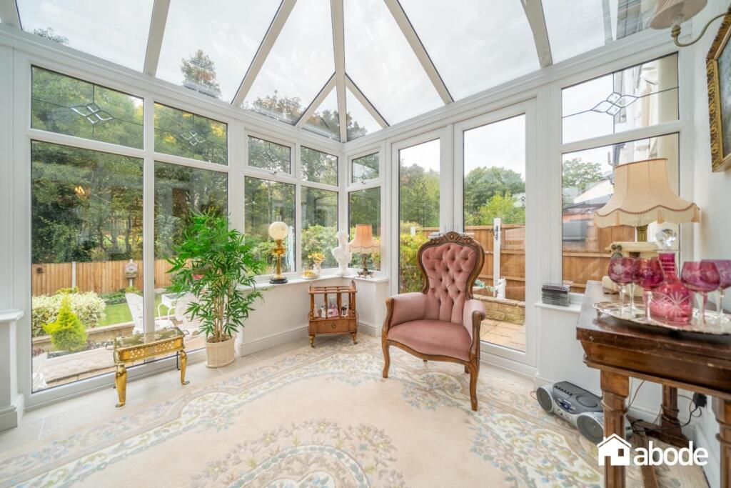
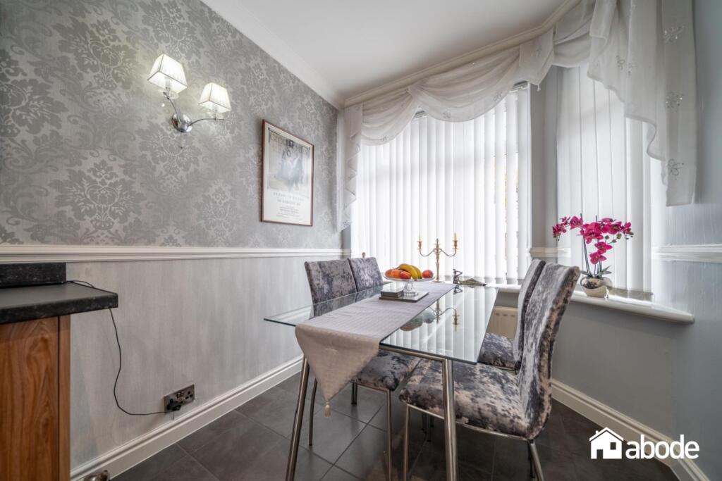
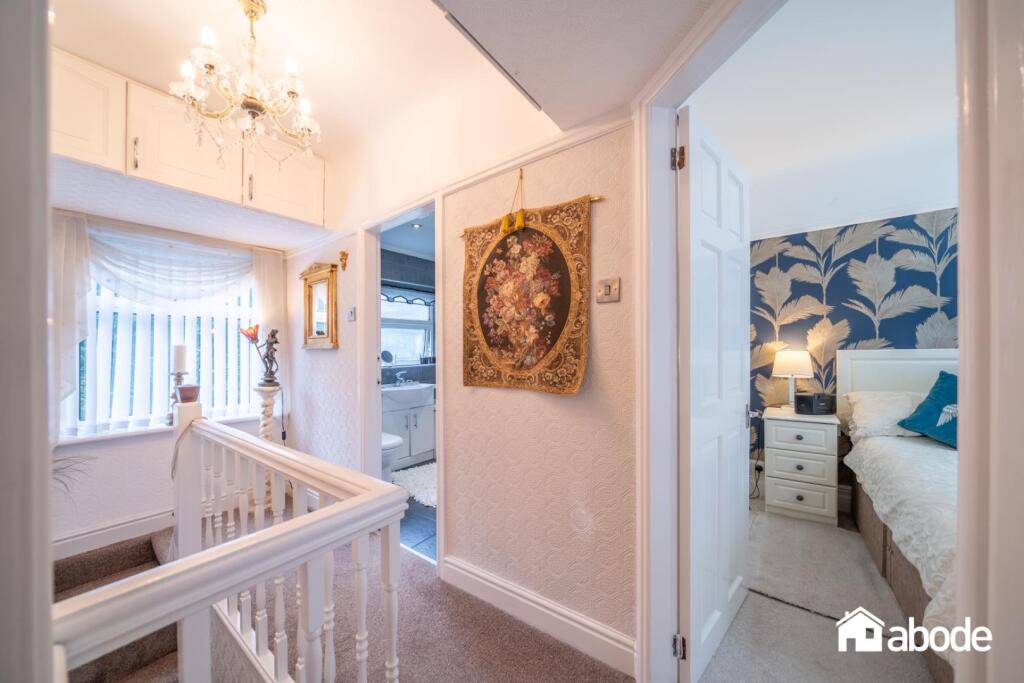
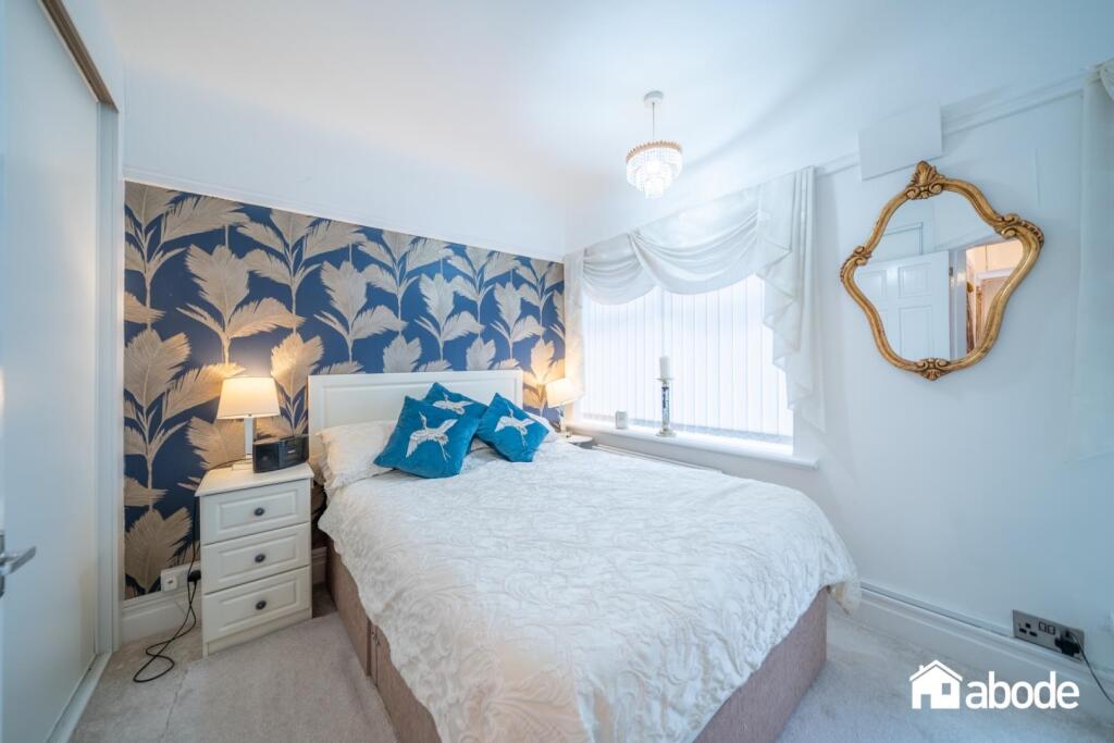
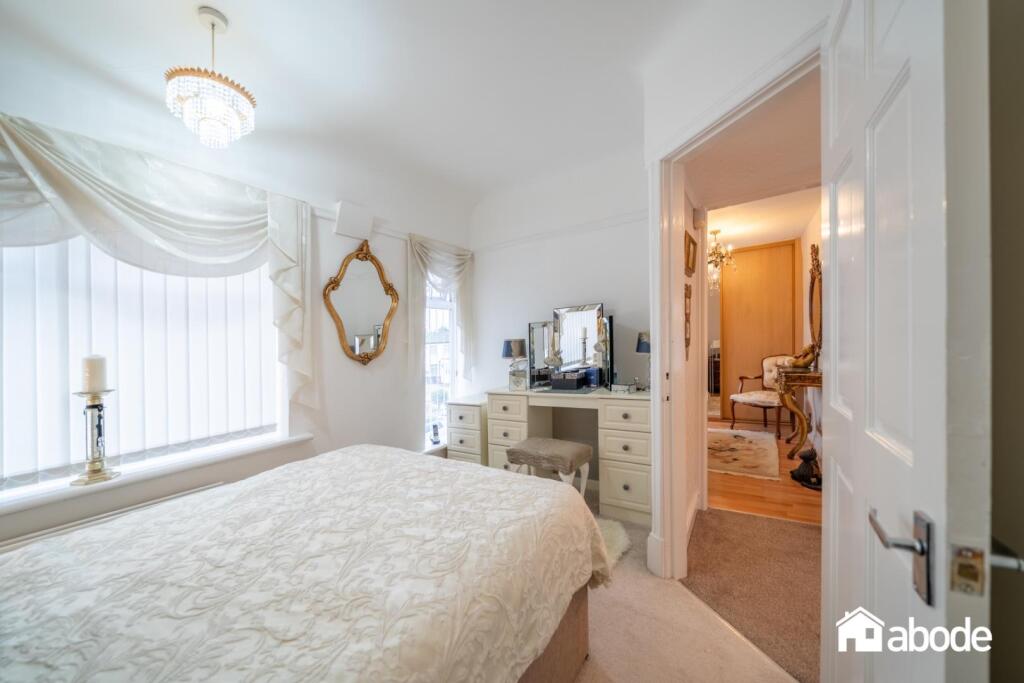
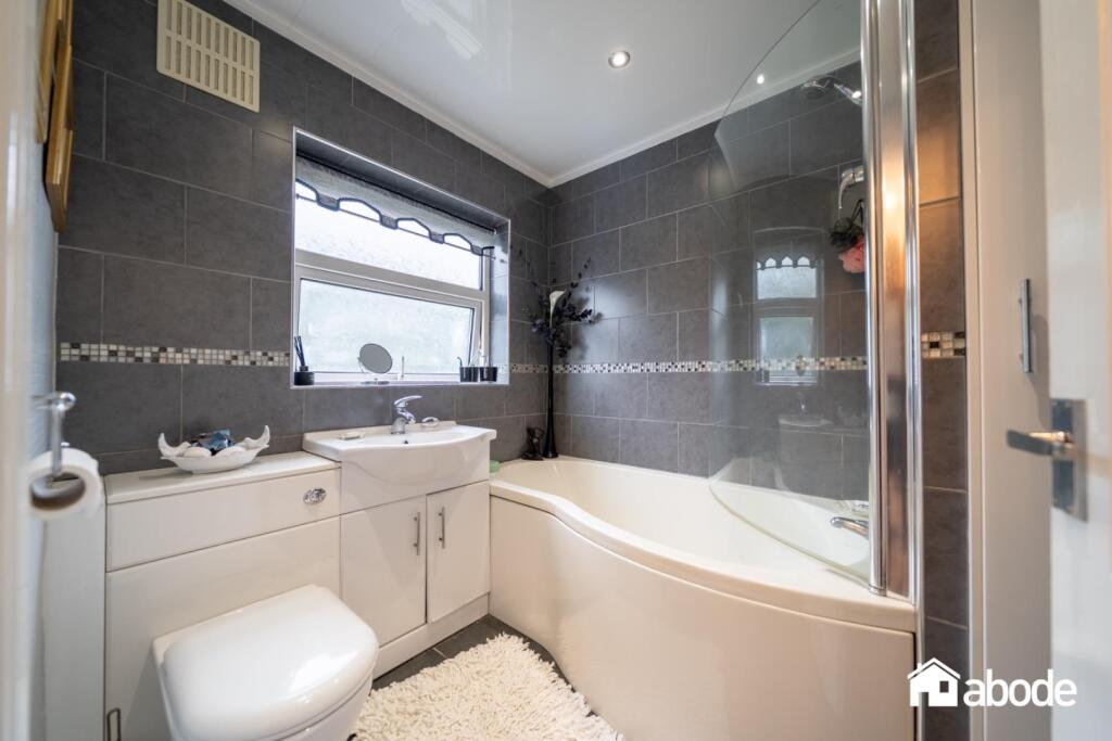
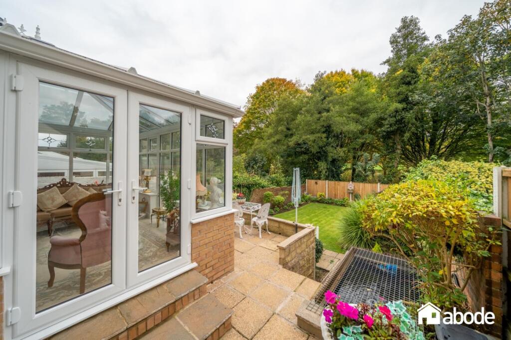
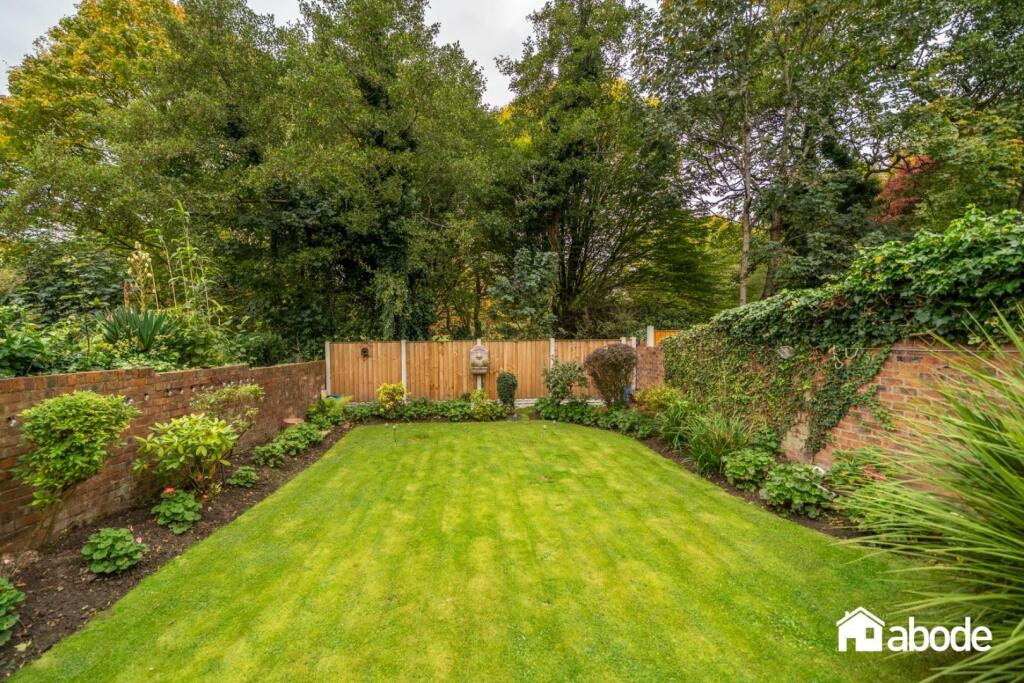
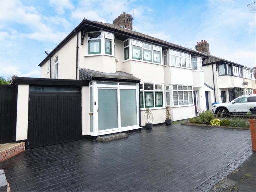
- Semi-detached, double-fronted family home in Childwall. The property presents a wide paved forecourt providing off-road parking and access to a single garage to the side. Exterior appears recently rendered/painted with a tiled roof. Internally the images show two principal reception rooms (formal sitting room with fireplace and a second reception), a fitted kitchen with a separate utility/side access corridor and a conservatory-style rear extension providing additional living space. The accommodation is arranged over two floors and is described/listed as having three bedrooms and one bathroom. The rear garden is of a good/large size with a well-maintained lawn and mature planting, offering a private family garden with scope for landscaping or entertaining. Overall the property is a mid-sized family home in good decorative order externally and generally well presented internally; typical of a suburban, family-orientated residence with off-street parking, garage and sizeable rear garden. No internal floor area (sq ft) shown on the images.
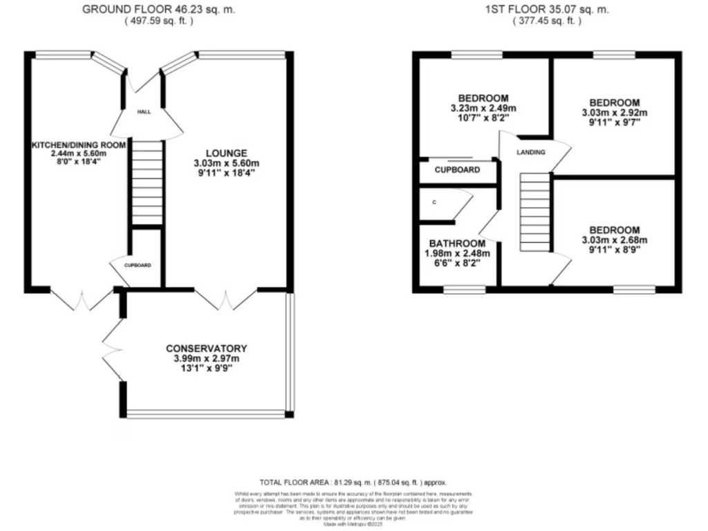
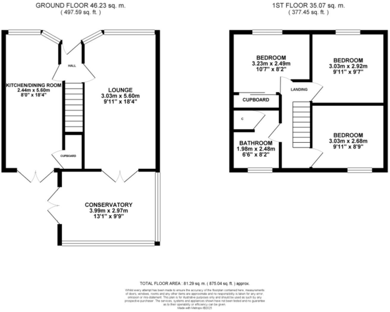
- Two‑storey residential dwelling shown in the listing floor plans. Layout indicates a ground floor with entrance hall, lounge and kitchen/dining area and a first floor with three bedrooms and a family bathroom. Property appears to be a typical suburban family home of average plot size with an average rear garden and a small front garden/forecourt. Location map places the property in the Liverpool area (near local parks and main road links). Suitable for purchaser seeking a mid‑market, family residence; likely benefits from good local amenities and transport links. Condition and internal fixtures cannot be assessed from the images; measurements and exact room sizes should be confirmed by inspection or from the agent's full particulars.
Image Descriptions
- semi-detached house mid-20th century
- backyard and conservatory mid-20th century suburban
Rooms
- KITCHEN/DINING ROOM:
- LOUNGE:
- CONSERVATORY:
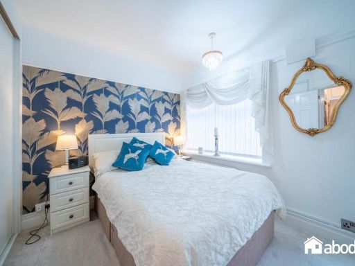
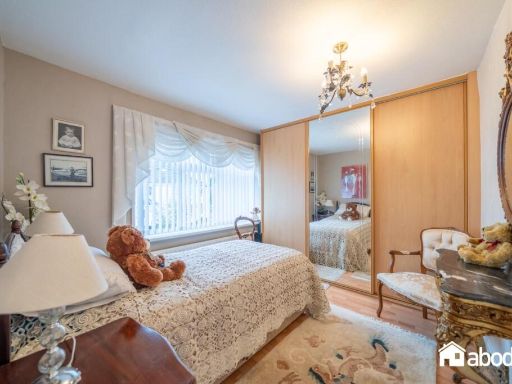
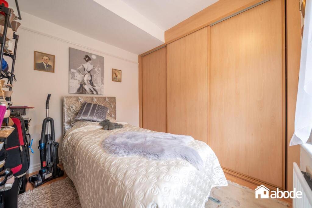
- BEDROOM:
- BEDROOM:
- BEDROOM:
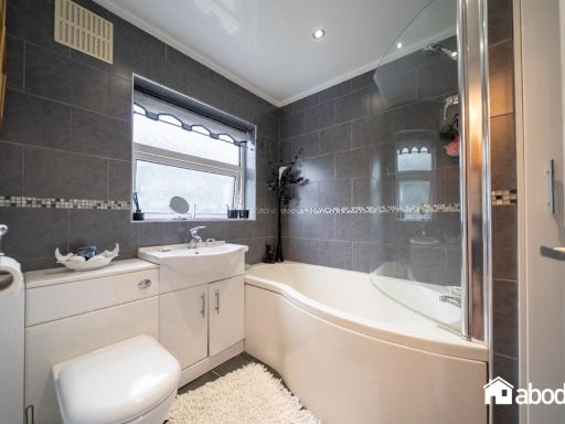
- BATHROOM:
Textual Property Features
Detected Visual Features
- semi-detached
- mid-20th century
- brick construction
- driveway
- garage
- garden
- suburban
- terrace
- backyard
- conservatory
- landscaped garden
- outdoor seating
- brick wall
EPC Details
- Fully double glazed
- Solid brick, as built, no insulation (assumed)
- Boiler and radiators, mains gas
- Low energy lighting in all fixed outlets
- Suspended, no insulation (assumed)
Nearby Schools
- Our Lady of the Assumption Catholic Primary School
- St Paschal Baylon Catholic Primary School
- Childwall Church of England Primary School
- Dixons Broadgreen Academy
- St Margaret Mary's Catholic Junior School
- Broughton Hall Catholic High School
- Blackmoor Park Junior School
- Rudston Primary School
- Malvern Primary School
- Roby Park Primary School
- NexGen Academy
- Blueberry Park
- Cardinal Heenan Catholic High School
- Belle Vale Community Primary School
- Childwall Valley Primary School
- Childwall Sports & Science Academy
- St Margaret Mary's Catholic Infant School
- Dovecot Primary School
- Park View Academy
Nearest Bars And Restaurants
- Id: 572701408
- Tags:
- Addr:
- City: Liverpool
- Housenumber: 2
- Postcode: L14 3PA
- Street: Bowring Park Road
- Amenity: pub
- Brewery: various
- Building: yes
- Name: The Rocket
- Outdoor_seating: yes
- Phone: +44 151 259 4694
- TagsNormalized:
- Lat: 53.4062267
- Lon: -2.8997126
- FullGeoHash: gcmzy423zf1x
- PartitionGeoHash: gcmz
- Images:
- FoodStandards: null
- Distance: 1582.9
,- Id: 559723982
- Tags:
- Amenity: pub
- Building: yes
- Name: The Stanley Arms
- Outdoor_seating: yes
- Smoking: no
- TagsNormalized:
- Lat: 53.4089891
- Lon: -2.8529685
- FullGeoHash: gcmzz4f9cj0m
- PartitionGeoHash: gcmz
- Images:
- FoodStandards: null
- Distance: 1546.4
,- Id: 507336647
- Tags:
- Amenity: pub
- Building: yes
- Name: Childwall Abbey
- Source: OS OpenMap Local
- Wikidata: Q26569509
- TagsNormalized:
- Lat: 53.3952821
- Lon: -2.8824882
- FullGeoHash: gcmzy2m414j0
- PartitionGeoHash: gcmz
- Images:
- FoodStandards: null
- Distance: 1294.6
,- Id: 559723978
- Tags:
- Amenity: pub
- Building: yes
- Name: The Derby Lodge
- Outdoor_seating: yes
- Smoking: no
- TagsNormalized:
- Lat: 53.4086132
- Lon: -2.8578137
- FullGeoHash: gcmzyfxp8p5e
- PartitionGeoHash: gcmz
- Images:
- FoodStandards: null
- Distance: 1223.5
,- Id: 419028112
- Tags:
- Amenity: restaurant
- Cuisine: indian
- Name: Khalisa
- TagsNormalized:
- Lat: 53.4006361
- Lon: -2.8863766
- FullGeoHash: gcmzy361q81d
- PartitionGeoHash: gcmz
- Images:
- FoodStandards: null
- Distance: 935.5
}
Nearest General Shops
- Id: 293646835
- Tags:
- Created_by: Potlatch 0.10b
- Name: New Image
- Shop: salon
- TagsNormalized:
- Lat: 53.3943944
- Lon: -2.8899259
- FullGeoHash: gcmzy0psgue1
- PartitionGeoHash: gcmz
- Images:
- FoodStandards: null
- Distance: 1613.8
,- Id: 6319258619
- Tags:
- Addr:
- City: Liverpool
- Housenumber: 4
- Postcode: L14 7QH
- Street: Swanside Parade
- Name: Bics DIY Centre
- Phone: +44 151 228 7662
- Shop: doityourself
- TagsNormalized:
- Lat: 53.4162433
- Lon: -2.8819826
- FullGeoHash: gcmzykjkhvqn
- PartitionGeoHash: gcmz
- Images:
- FoodStandards: null
- Distance: 1185.9
,- Id: 1137838996
- Tags:
- TagsNormalized:
- Lat: 53.4066059
- Lon: -2.8858577
- FullGeoHash: gcmzy66s48ut
- PartitionGeoHash: gcmz
- Images:
- FoodStandards: null
- Distance: 665.8
}
Nearest Grocery shops
- Id: 6342973303
- Tags:
- Name: Daily Stop
- Shop: convenience
- TagsNormalized:
- Lat: 53.4200222
- Lon: -2.8744778
- FullGeoHash: gcmzysff5vfh
- PartitionGeoHash: gcmz
- Images:
- FoodStandards: null
- Distance: 1536.5
,- Id: 6311518660
- Tags:
- Name: Today's Extra
- Shop: convenience
- TagsNormalized:
- Lat: 53.4160962
- Lon: -2.8814355
- FullGeoHash: gcmzykjg3djc
- PartitionGeoHash: gcmz
- Images:
- FoodStandards: null
- Distance: 1158.4
,- Id: 10181543472
- Tags:
- Addr:
- Housenumber: 102
- Street: Bentham Drive
- Branch: Bentham Drive
- Brand: Co-op Food
- Brand:wikidata: Q3277439
- Name: Co-op Food
- Opening_hours: Mo-Su 07:00-22:00
- Phone: 0151 737 1845
- Shop: convenience
- Website: https://www.coop.co.uk/store-finder/L16-5EX/102-bentham-drive?utm_source=gmb&utm_medium=organic&utm_campaign=gmb-Bentham-Drive-Liverpool
- TagsNormalized:
- co-op
- co-op food
- food
- convenience
- shop
- Lat: 53.4005556
- Lon: -2.885943
- FullGeoHash: gcmzy368b9hf
- PartitionGeoHash: gcmz
- Images:
- FoodStandards: null
- Distance: 920.3
}
Nearest Supermarkets
- Id: 493479392
- Tags:
- Brand: Sainsbury's
- Brand:wikidata: Q152096
- Brand:wikipedia: en:Sainsbury's
- Building: yes
- Name: Sainsbury's
- Shop: supermarket
- TagsNormalized:
- sainsburys
- supermarket
- shop
- Lat: 53.4150435
- Lon: -2.898082
- FullGeoHash: gcmzy5ctjvc3
- PartitionGeoHash: gcmz
- Images:
- FoodStandards: null
- Distance: 1770.7
,- Id: 729739681
- Tags:
- Brand: ALDI
- Brand:wikidata: Q41171672
- Brand:wikipedia: en:Aldi
- Building: yes
- Contact:
- Website: https://stores.aldi.co.uk/gateacre/gateacre-park-drive
- Name: ALDI
- Operator: ALDI
- Shop: supermarket
- TagsNormalized:
- Lat: 53.3912691
- Lon: -2.8721372
- FullGeoHash: gcmzwxsddmgm
- PartitionGeoHash: gcmz
- Images:
- FoodStandards: null
- Distance: 1681.3
,- Id: 479747647
- Tags:
- Brand: ALDI
- Brand:wikidata: Q41171672
- Brand:wikipedia: en:Aldi
- Building: yes
- Contact:
- Website: https://stores.aldi.co.uk/liverpool/367-east-prescot-road
- Name: ALDI
- Shop: supermarket
- TagsNormalized:
- Lat: 53.4196981
- Lon: -2.8862129
- FullGeoHash: gcmzykf2637x
- PartitionGeoHash: gcmz
- Images:
- FoodStandards: null
- Distance: 1648.2
}
Nearest Religious buildings
- Id: 507336816
- Tags:
- Amenity: place_of_worship
- Building: yes
- Denomination: catholic
- Name: St Margaret Mary's Roman Catholic Church
- Religion: christian
- Source: OS OpenMap Local
- TagsNormalized:
- place of worship
- catholic
- church
- roman catholic
- christian
- Lat: 53.4139311
- Lon: -2.8772732
- FullGeoHash: gcmzye8ydwmw
- PartitionGeoHash: gcmz
- Images:
- FoodStandards: null
- Distance: 861.8
,- Id: 507336817
- Tags:
- Amenity: place_of_worship
- Building: yes
- Denomination: catholic
- Name: St Margaret Mary's Roman Catholic Church
- Religion: christian
- Source: OS OpenMap Local
- TagsNormalized:
- place of worship
- catholic
- church
- roman catholic
- christian
- Lat: 53.4136956
- Lon: -2.8779812
- FullGeoHash: gcmzye8m64t9
- PartitionGeoHash: gcmz
- Images:
- FoodStandards: null
- Distance: 842.5
,- Id: 1604808950
- Tags:
- Amenity: place_of_worship
- Denomination: methodist
- Name: Court Hey Methodist Church
- Religion: christian
- TagsNormalized:
- place of worship
- methodist
- church
- christian
- Lat: 53.407626
- Lon: -2.8747164
- FullGeoHash: gcmzydd9yr04
- PartitionGeoHash: gcmz
- Images:
- FoodStandards: null
- Distance: 172.2
}
Nearest Medical buildings
- Id: 301368198
- Tags:
- Amenity: hospital
- Healthcare: hospital
- Name: Broadgreen Hospital
- Wikidata: Q4972190
- TagsNormalized:
- Lat: 53.4115429
- Lon: -2.8978912
- FullGeoHash: gcmzy53bf1px
- PartitionGeoHash: gcmz
- Images:
- FoodStandards: null
- Distance: 1577
,- Id: 247414365
- Tags:
- Amenity: pharmacy
- Dispensing: yes
- Healthcare: pharmacy
- TagsNormalized:
- Lat: 53.4194457
- Lon: -2.8765559
- FullGeoHash: gcmzys9qg6km
- PartitionGeoHash: gcmz
- Images:
- FoodStandards: null
- Distance: 1470.5
,- Id: 301368133
- Tags:
- Amenity: parking
- Building: yes
- Name: Liverpool Heart & Chest Hospital & Broadgreen Hospital Car Park
- Parking: multi-storey
- TagsNormalized:
- Lat: 53.4114118
- Lon: -2.8942083
- FullGeoHash: gcmzy5k800cc
- PartitionGeoHash: gcmz
- Images:
- FoodStandards: null
- Distance: 1347.5
,- Id: 507336807
- Tags:
- Amenity: hospital
- Healthcare: hospital
- Name: Nursing Home
- Source: OS OpenMap Local
- TagsNormalized:
- hospital
- health
- healthcare
- nursing home
- Lat: 53.3996658
- Lon: -2.871396
- FullGeoHash: gcmzy9j5ee5y
- PartitionGeoHash: gcmz
- Images:
- FoodStandards: null
- Distance: 786.7
}
Nearest Airports
- Id: 116737532
- Tags:
- Addr:
- City: Liverpool
- Country: GB
- Postcode: L24 1YD
- Street: Speke Hall Avenue
- Aerodrome: international
- Aerodrome:type: public
- Aeroway: aerodrome
- Iata: LPL
- Icao: EGGP
- Is_in: Liverpool,England,UK
- Name: Liverpool John Lennon Airport
- Old_name: Speke Airport
- Operator: Liverpool Airport plc
- Source: wikipedia
- Website: https://www.liverpoolairport.com/
- Wikidata: Q8727
- Wikipedia: en:Liverpool John Lennon Airport
- TagsNormalized:
- airport
- international airport
- Lat: 53.3357677
- Lon: -2.8518179
- FullGeoHash: gcmzrj7r7gdr
- PartitionGeoHash: gcmz
- Images:
- FoodStandards: null
- Distance: 7995.2
}
Nearest Leisure Facilities
- Id: 35840103
- Tags:
- TagsNormalized:
- Lat: 53.4028491
- Lon: -2.8854809
- FullGeoHash: gcmzy3dy5kt7
- PartitionGeoHash: gcmz
- Images:
- FoodStandards: null
- Distance: 741.7
,- Id: 413304038
- Tags:
- Leisure: pitch
- Source: Bing
- TagsNormalized:
- Lat: 53.4006207
- Lon: -2.873372
- FullGeoHash: gcmzy979jt4w
- PartitionGeoHash: gcmz
- Images:
- FoodStandards: null
- Distance: 644.5
,- Id: 413304039
- Tags:
- Leisure: pitch
- Source: Bing
- TagsNormalized:
- Lat: 53.4011972
- Lon: -2.8730821
- FullGeoHash: gcmzy97us2dt
- PartitionGeoHash: gcmz
- Images:
- FoodStandards: null
- Distance: 588.4
,- Id: 907841762
- Tags:
- Leisure: pitch
- Sport: bowls
- TagsNormalized:
- Lat: 53.404138
- Lon: -2.8741556
- FullGeoHash: gcmzy9gjekf7
- PartitionGeoHash: gcmz
- Images:
- FoodStandards: null
- Distance: 257.6
,- Id: 147257241
- Tags:
- Leisure: park
- Name: Court Hey Park
- Wikidata: Q5178230
- TagsNormalized:
- Lat: 53.4041833
- Lon: -2.8760215
- FullGeoHash: gcmzy9ctzv6f
- PartitionGeoHash: gcmz
- Images:
- FoodStandards: null
- Distance: 227.7
}
Nearest Tourist attractions
- Id: 2800742273
- Tags:
- Addr:
- Housenumber: 100
- Street: Green Lane
- Name: Somersby Guest House
- Phone: +44 151 7227549
- Tourism: guest_house
- Website: http://www.somersbyguesthouse.com/
- TagsNormalized:
- Lat: 53.3882922
- Lon: -2.8982351
- FullGeoHash: gcmzwp1965p2
- PartitionGeoHash: gcmz
- Images:
- FoodStandards: null
- Distance: 2486.7
,- Id: 5099038121
- Tags:
- Name: Stuart Sutcliffe grave
- Name:ru: Могила Стюарта Сатклиффа
- Tourism: attraction
- TagsNormalized:
- Lat: 53.4140411
- Lon: -2.8426872
- FullGeoHash: gcmzz7dp2dfy
- PartitionGeoHash: gcmz
- Images:
- FoodStandards: null
- Distance: 2362.5
,- Id: 1604863902
- Tags:
- Name: National Wildflower Centre
- Tourism: attraction
- TagsNormalized:
- Lat: 53.4043251
- Lon: -2.8765048
- FullGeoHash: gcmzy9cqsxf8
- PartitionGeoHash: gcmz
- Images:
- FoodStandards: null
- Distance: 216.2
}
Nearest Train stations
- Id: 6414583116
- Tags:
- Name: Mossley Hill
- Naptan:
- Network: National Rail
- Postal_code: L18 8AG
- Public_transport: station
- Railway: station
- Ref:
- Wheelchair: yes
- Wikidata: Q1998870
- Wikipedia: en:Mossley Hill railway station
- TagsNormalized:
- Lat: 53.3785566
- Lon: -2.914829
- FullGeoHash: gcmzttm2xs1u
- PartitionGeoHash: gcmz
- Images:
- FoodStandards: null
- Distance: 4019.2
,- Id: 24825515
- Tags:
- Name: Wavertree Technology Park
- Naptan:
- Network: National Rail
- Public_transport: station
- Railway: station
- Ref:
- Train: yes
- Wheelchair: yes
- Wikidata: Q2969859
- Wikipedia: en:Wavertree Technology Park railway station
- TagsNormalized:
- Lat: 53.4052171
- Lon: -2.9228151
- FullGeoHash: gcmzv6pevqp1
- PartitionGeoHash: gcmz
- Images:
- FoodStandards: null
- Distance: 3116.4
,- Id: 255276373
- Tags:
- Name: Huyton
- Naptan:
- Network: National Rail
- Public_transport: station
- Railway: station
- Ref:
- Website: https://www.nationalrail.co.uk/stations_destinations/huy.aspx
- Wikidata: Q946322
- Wikipedia: en:Huyton railway station
- TagsNormalized:
- Lat: 53.4095394
- Lon: -2.8433204
- FullGeoHash: gcmzz6ct1gf8
- PartitionGeoHash: gcmz
- Images:
- FoodStandards: null
- Distance: 2186.3
,- Id: 3680050751
- Tags:
- Name: Roby
- Naptan:
- Network: National Rail
- Public_transport: station
- Railway: station
- Ref:
- Train: yes
- Wikidata: Q3063201
- Wikipedia: en:Roby railway station
- TagsNormalized:
- Lat: 53.4100591
- Lon: -2.8555038
- FullGeoHash: gcmzz508juwh
- PartitionGeoHash: gcmz
- Images:
- FoodStandards: null
- Distance: 1413.3
,- Id: 152294619
- Tags:
- Name: Broad Green
- Naptan:
- Network: National Rail
- Public_transport: station
- Railway: station
- Ref:
- Wikidata: Q2629741
- Wikipedia: en:Broad Green railway station
- TagsNormalized:
- Lat: 53.4065083
- Lon: -2.8933889
- FullGeoHash: gcmzy4m57nsz
- PartitionGeoHash: gcmz
- Images:
- FoodStandards: null
- Distance: 1164.1
}
Nearest Hotels
- Id: 1065731062
- Tags:
- Addr:
- City: Liverpool
- Housenumber: 502
- Postcode: L13 0AS
- Street: Queens Drive
- Brand: Travelodge
- Brand:wikidata: Q9361374
- Building: yes
- Fhrs:
- Authority: Liverpool
- Id: 498295
- Local_authority_id: PI/000243159
- Internet_access: wlan
- Internet_access:fee: customers
- Internet_access:ssid: Travelodge WiFi
- Name: Travelodge Liverpool StoneyCroft
- Tourism: hotel
- TagsNormalized:
- Lat: 53.4204806
- Lon: -2.9098865
- FullGeoHash: gcmzvuchfer7
- PartitionGeoHash: gcmz
- Images:
- FoodStandards: null
- Distance: 2757.8
,- Id: 533863686
- Tags:
- Amenity: taxi
- Name: DERBY LODGE HOTEL CAR PARK
- Naptan:
- AtcoCode: 2800TX00064
- CommonName: DERBY LODGE HOTEL CAR PARK
- Indicator: DERBY LODGE HOTEL CAR PARK
- Landmark: IN THE HOTEL CAR PARK OPPOSITE THE MAIN ENTRANCE
- Notes: No Notes
- PlusbusZoneRef: LVRPLCH
- Street: ROBY ROAD
- Verified: no
- Source: naptan_import
- TagsNormalized:
- Lat: 53.4086518
- Lon: -2.8582276
- FullGeoHash: gcmzyfwxyqr1
- PartitionGeoHash: gcmz
- Images:
- FoodStandards: null
- Distance: 1197.7
,- Id: 559723977
- Tags:
- Brand: Premier Inn
- Brand:wikidata: Q2108626
- Brand:wikipedia: en:Premier Inn
- Building: yes
- Internet_access: wlan
- Internet_access:fee: customers
- Internet_access:operator: Virgin Media
- Internet_access:ssid: Premier Inn Free Wi-Fi
- Name: Premier Inn
- Tourism: hotel
- TagsNormalized:
- Lat: 53.4084558
- Lon: -2.8582066
- FullGeoHash: gcmzyfwwycy8
- PartitionGeoHash: gcmz
- Images:
- FoodStandards: null
- Distance: 1194.4
}
Tags
- semi-detached
- mid-20th century
- brick construction
- driveway
- garage
- garden
- mid-20th century
- suburban
- terrace
- backyard
- conservatory
- landscaped garden
- outdoor seating
- brick wall
Local Market Stats
- Average Price/sqft: £270
- Avg Income: £50200
- Social Housing: 5%
- Planning Success Rate: 94%
Similar Properties
 3 bedroom semi-detached house for sale in Court Hey Road, Childwall, Liverpool, L16 — £335,000 • 3 bed • 1 bath • 993 ft²
 3 bedroom semi-detached house for sale in Thornton Road, Childwall, Liverpool, L16 — £335,000 • 3 bed • 1 bath • 1075 ft²
 3 bedroom semi-detached house for sale in Babbacombe Road, Childwall, Liverpool, L16 — £595,000 • 3 bed • 2 bath • 1749 ft²
 3 bedroom semi-detached house for sale in Molesworth Grove, Childwall, Liverpool L16 — £260,000 • 3 bed • 1 bath • 876 ft²
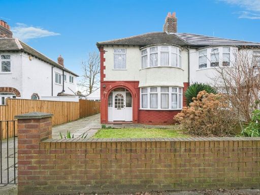 3 bedroom semi-detached house for sale in Childwall Road, Liverpool, L15 — £330,000 • 3 bed • 1 bath • 954 ft²
 4 bedroom detached house for sale in Castletown Close, Childwall, Liverpool, L16 — £450,000 • 4 bed • 3 bath • 1266 ft²
Meta
- {
"@context": "https://schema.org",
"@type": "Residence",
"name": "3 bedroom semidetached house for sale in Court Hey Road, Ch…",
"description": "",
"url": "https://propertypiper.co.uk/property/368d174e-ba93-4423-a09a-7b7b00fd6be9",
"image": "https://image-a.propertypiper.co.uk/52b778bc-d5d1-4009-a5aa-fb913919b99b-1024.jpeg",
"address": {
"@type": "PostalAddress",
"streetAddress": "30 Court Hey Road",
"postalCode": "L16 2LZ",
"addressLocality": "Knowsley",
"addressRegion": "Knowsley",
"addressCountry": "England"
},
"geo": {
"@type": "GeoCoordinates",
"latitude": 53.40622797535661,
"longitude": -2.8758333365311035
},
"numberOfRooms": 3,
"numberOfBathroomsTotal": 1,
"floorSize": {
"@type": "QuantitativeValue",
"value": 875,
"unitCode": "FTK"
},
"offers": {
"@type": "Offer",
"price": 335000,
"priceCurrency": "GBP",
"availability": "https://schema.org/InStock"
},
"additionalProperty": [
{
"@type": "PropertyValue",
"name": "Feature",
"value": "semi-detached"
},
{
"@type": "PropertyValue",
"name": "Feature",
"value": "mid-20th century"
},
{
"@type": "PropertyValue",
"name": "Feature",
"value": "brick construction"
},
{
"@type": "PropertyValue",
"name": "Feature",
"value": "driveway"
},
{
"@type": "PropertyValue",
"name": "Feature",
"value": "garage"
},
{
"@type": "PropertyValue",
"name": "Feature",
"value": "garden"
},
{
"@type": "PropertyValue",
"name": "Feature",
"value": "mid-20th century"
},
{
"@type": "PropertyValue",
"name": "Feature",
"value": "suburban"
},
{
"@type": "PropertyValue",
"name": "Feature",
"value": "terrace"
},
{
"@type": "PropertyValue",
"name": "Feature",
"value": "backyard"
},
{
"@type": "PropertyValue",
"name": "Feature",
"value": "conservatory"
},
{
"@type": "PropertyValue",
"name": "Feature",
"value": "landscaped garden"
},
{
"@type": "PropertyValue",
"name": "Feature",
"value": "outdoor seating"
},
{
"@type": "PropertyValue",
"name": "Feature",
"value": "brick wall"
}
]
}
High Res Floorplan Images
Compatible Floorplan Images
FloorplanImages Thumbnail