PL5 4AD - 1 bedroom apartment for sale in Lancaster Gardens, Plymouth…
View on Property Piper
1 bedroom apartment for sale in Lancaster Gardens, Plymouth, Devon, PL5
Property Details
- Price: £90000
- Bedrooms: 1
- Bathrooms: 1
- Property Type: undefined
- Property SubType: undefined
Brochure Descriptions
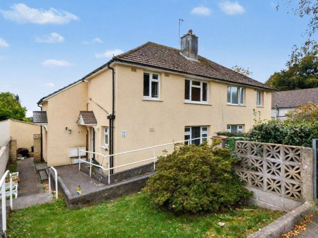
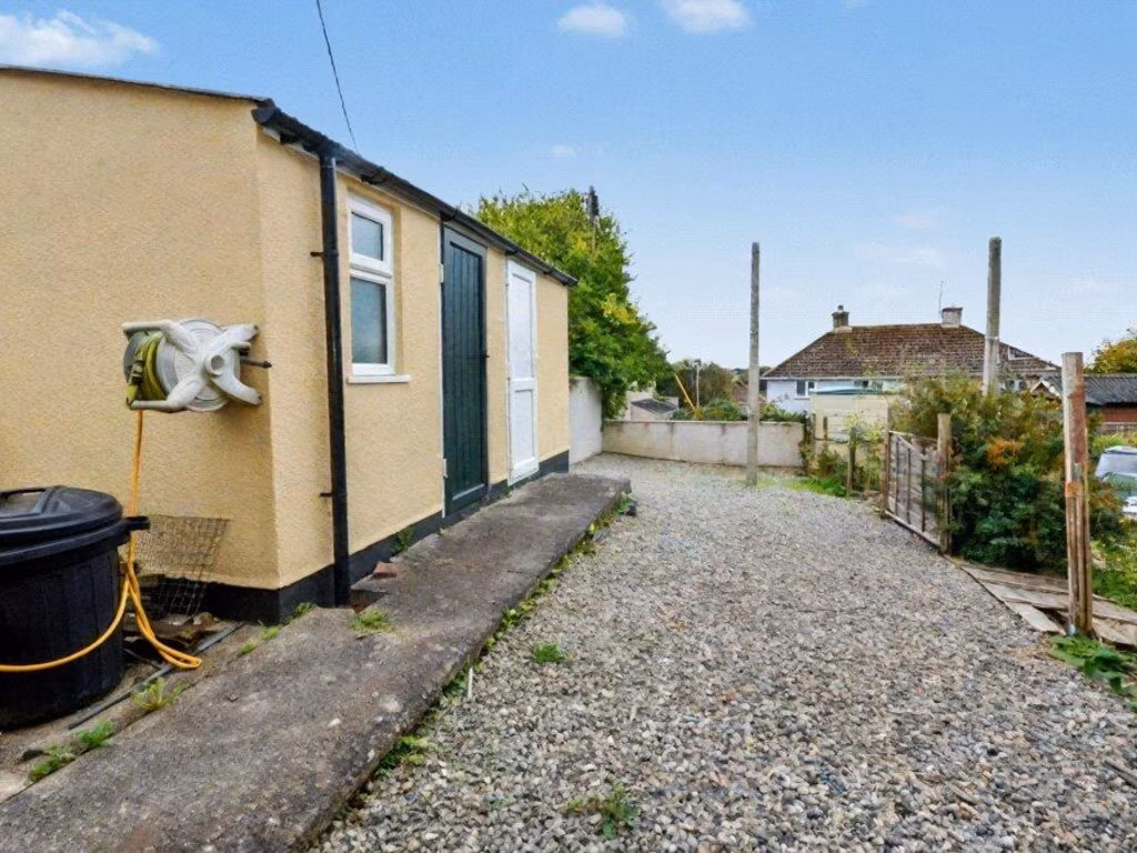
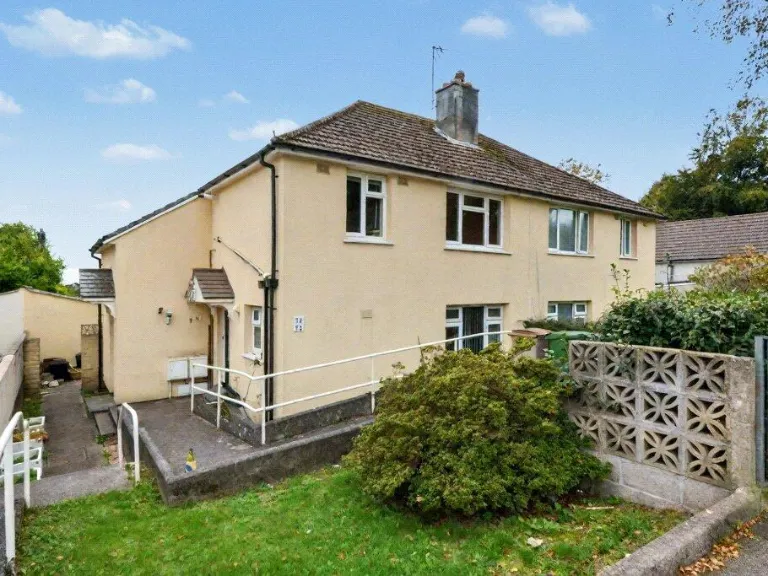
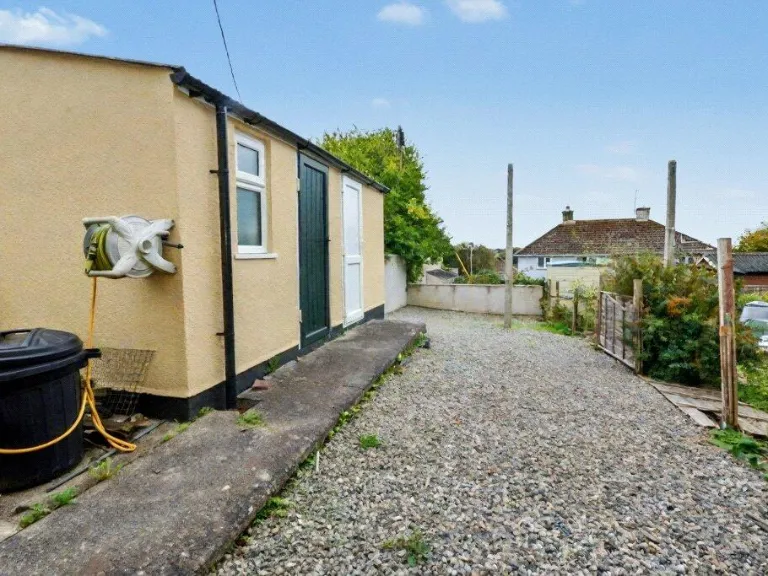
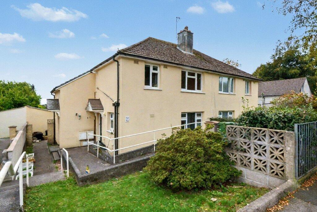
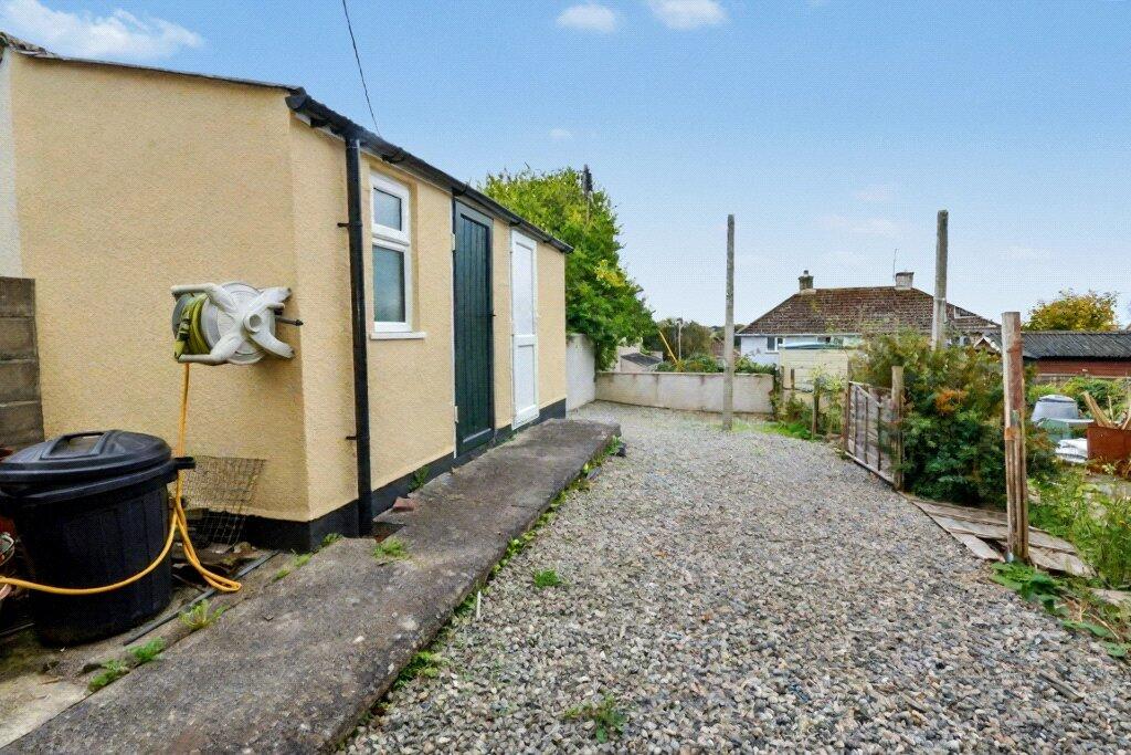
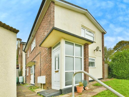
- Two-storey semi-detached residential property finished in a pale render with a pitched tiled roof. The property appears to sit on a slightly elevated plot with a small front lawn, low boundary wall and mature shrubbery. There is a paved side access/driveway leading to outbuildings/garage at the rear and a gated pedestrian entrance. A ground-floor ramp and handrail indicate level access provision. The immediate outlook is suburban with nearby trees and neighbouring houses visible — no sea, river or exceptional long-range view evident. The front garden is small; overall plot and property footprint are modest to average for a suburban semi-detached home. The building form suggests a standard two-bedroom or three-bedroom family layout (noting internal layout is not visible).
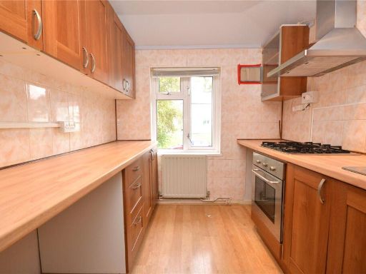
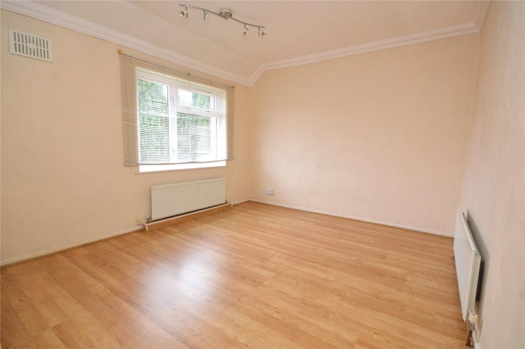
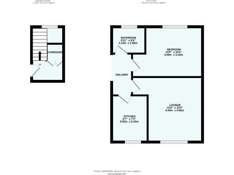
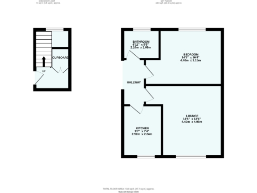
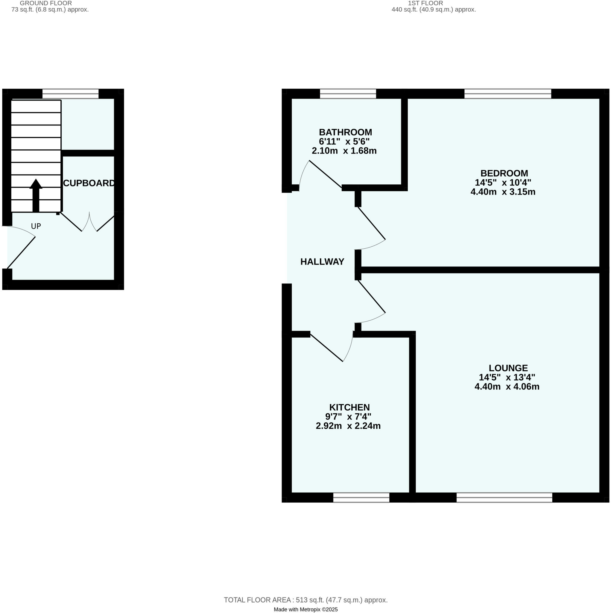
- One-bedroom apartment shown as a compact self-contained flat on a single main living level with a small entrance/stair area. The floorplan indicates: a lounge of average size, one double bedroom, a kitchen, a bathroom, and a central hallway with a storage cupboard. Overall property footprint appears small-to-average for a one-bedroom flat (suitable for single occupant or couple). No external features or garden are shown and no notable views are indicated on the plan. The layout is straightforward and efficient with separate living and sleeping accommodation and internal storage; suitable for buy-to-let or first-time buyer market.
Image Descriptions
- semi-detached house mid-20th century
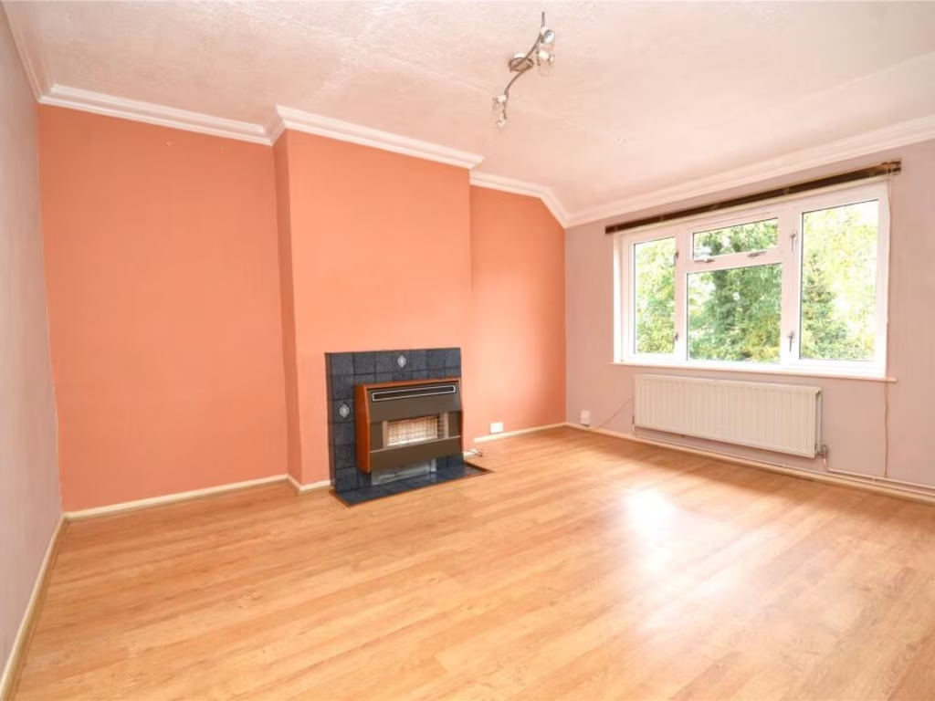
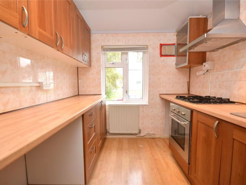
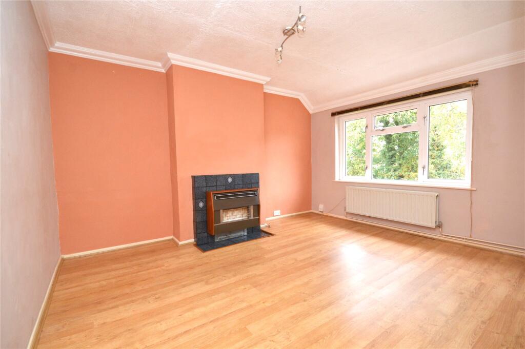
- living room mid-20th century
Floorplan Description
- Two-floor property with lounge, kitchen, bedroom, bathroom and cupboard.
Rooms
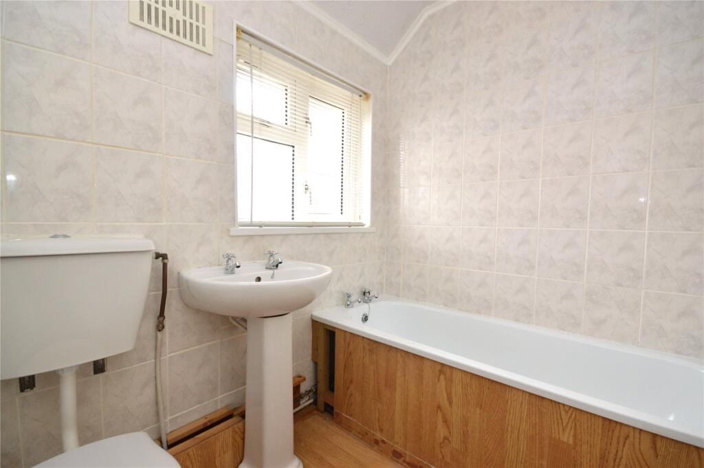
- BATHROOM:
- BEDROOM:
- LOUNGE:
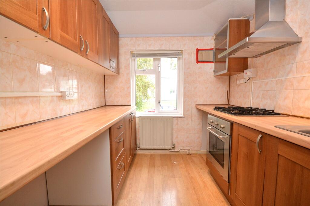
- KITCHEN:
- HALLWAY:
- CUPBOARD:
Textual Property Features
- Has Garden
- Chain Free
- Success
Detected Visual Features
- semi-detached
- mid-20th century
- two-story
- garden
- access ramp
- parking potential
- external stairs
- dual-entrance
- rendered exterior
- living room
- fireplace
- laminate flooring
- window
- radiator
- cornicing
- outdated
- medium room
EPC Details
- Fully double glazed
- Cavity wall, filled cavity
- Boiler and radiators, mains gas
- Low energy lighting in 56% of fixed outlets
- Solid, no insulation (assumed)
Nearby Schools
- King's School
- Compton CofE Primary School
- Pennycross Primary School
- Eggbuckland Community College
- Manadon Vale Primary School
- Shakespeare Primary School
- St Matthew's Church of England Primary and Nursery Academy
- Whitleigh Community Primary School
- Notre Dame RC School
- Oakwood Primary Academy
- Hyde Park Junior School
- Montpelier Primary School
- Widey Court Primary School
- St Boniface's RC College
- Woodfield Primary School
- St Peter's RC Primary School
- Devonport High School for Girls
- Eggbuckland Vale Primary School
- All Saints Church of England Academy
- Knowle Primary School
- Sir John Hunt Community Sports College
- Beechwood Primary Academy
- Mary Dean's CofE Primary School and Nursery
- Ernesettle Community School
- Widewell Primary Academy
Nearest Bars And Restaurants
- Id: 917565248
- Tags:
- Amenity: fast_food
- Building: retail
- Cuisine: indian;kebab;fish_and_chips;chicken
- Mapillary: 321887742868207
- Name: Baba's 40 Dishes
- Survey:
- TagsNormalized:
- fast food
- food
- retail
- indian
- kebab
- fish
- chicken
- Lat: 50.4080131
- Lon: -4.1329097
- FullGeoHash: gbvncbqxbnxn
- PartitionGeoHash: gbvn
- Images:
- FoodStandards: null
- Distance: 1238.8
,- Id: 421174505
- Tags:
- Addr:
- City: Plymouth
- Housename: McDonald's Tavistock Road
- Postcode: PL6 5DA
- Street: Tavistock Road
- Amenity: fast_food
- Brand: McDonald's
- Brand:wikidata: Q38076
- Brand:wikipedia: en:McDonald's
- Building: yes
- Contact:
- Website: https://www.mcdonalds.com/gb/en-gb/location/plymouth/plymouth---tavistock-road/tavistock-road/8260729.html
- Cuisine: burger
- Drive_through: yes
- Name: McDonald's
- Takeaway: yes
- TagsNormalized:
- fast food
- food
- mcdonalds
- burgers
- drive through
- takeaway
- Lat: 50.4141953
- Lon: -4.1272277
- FullGeoHash: gbvnf1deux5u
- PartitionGeoHash: gbvn
- Images:
- FoodStandards: null
- Distance: 1169.4
,- Id: 5209179128
- Tags:
- Amenity: fast_food
- Delivery: no
- Drive_through: no
- Name: Warrens Bakery
- Outdoor_seating: no
- Smoking: no
- TagsNormalized:
- Lat: 50.4092552
- Lon: -4.1326857
- FullGeoHash: gbvncbwxjqq0
- PartitionGeoHash: gbvn
- Images:
- FoodStandards: null
- Distance: 1139.7
,- Id: 9166839218
- Tags:
- Amenity: cafe
- Name: Denzil's Pasties
- TagsNormalized:
- Lat: 50.4096059
- Lon: -4.1497776
- FullGeoHash: gbvnc8f1ppts
- PartitionGeoHash: gbvn
- Images:
- FoodStandards: null
- Distance: 954.5
,- Id: 506499088
- Tags:
- Amenity: pub
- Building: yes
- Name: The Albermarle
- Opening_hours: Su-Th 11:00-23:00,11:00-24:00
- TagsNormalized:
- Lat: 50.4185424
- Lon: -4.1539432
- FullGeoHash: gbvnc6rjq1e2
- PartitionGeoHash: gbvn
- Images:
- FoodStandards: null
- Distance: 785.2
}
Nearest General Shops
- Id: 240138268
- Tags:
- Building: yes
- Name: PDC Motoring Centre
- Shop: car_repair
- Source: bing
- TagsNormalized:
- Lat: 50.4157563
- Lon: -4.1347233
- FullGeoHash: gbvnccvjjfnu
- PartitionGeoHash: gbvn
- Images:
- FoodStandards: null
- Distance: 611.5
,- Id: 10210167420
- Tags:
- TagsNormalized:
- Lat: 50.4150231
- Lon: -4.1437062
- FullGeoHash: gbvnc9y8u9kx
- PartitionGeoHash: gbvn
- Images:
- FoodStandards: null
- Distance: 230.8
,- Id: 10210167419
- Tags:
- TagsNormalized:
- Lat: 50.4150447
- Lon: -4.1437961
- FullGeoHash: gbvnc9y8ft3x
- PartitionGeoHash: gbvn
- Images:
- FoodStandards: null
- Distance: 229.7
}
Nearest Grocery shops
- Id: 598520941
- Tags:
- Addr:
- Building: yes
- Name: Dunnets Local
- Opening_hours: Mo-Su 08:00-18:00
- Shop: convenience
- TagsNormalized:
- Lat: 50.4259006
- Lon: -4.1461226
- FullGeoHash: gbvnceubhm4v
- PartitionGeoHash: gbvn
- Images:
- FoodStandards: null
- Distance: 1005.7
,- Id: 646043528
- Tags:
- Building: retail
- Name: Budshead General Store
- Shop: convenience
- TagsNormalized:
- retail
- general
- convenience
- shop
- Lat: 50.4146016
- Lon: -4.1359632
- FullGeoHash: gbvnccsq34fk
- PartitionGeoHash: gbvn
- Images:
- FoodStandards: null
- Distance: 575.4
,- Id: 40608955
- Tags:
- Building: retail
- Building:levels: 1
- Name: Co-operative Food Supermarket
- Opening_hours: Mo-Sa 06:00-22:00; Su 10:00-16:00
- Shop: supermarket
- Wheelchair: yes
- TagsNormalized:
- Lat: 50.4185417
- Lon: -4.15026
- FullGeoHash: gbvncd3v7cmu
- PartitionGeoHash: gbvn
- Images:
- FoodStandards: null
- Distance: 532.8
}
Nearest Supermarkets
- Id: 917565242
- Tags:
- Brand: Co-op Food
- Brand:wikidata: Q3277439
- Brand:wikipedia: en:Co-op Food
- Building: retail
- Mapillary: 4616276741823670
- Name: Co-op Food
- Shop: supermarket
- Survey:
- TagsNormalized:
- co-op
- co-op food
- food
- retail
- supermarket
- shop
- Lat: 50.4078925
- Lon: -4.1329279
- FullGeoHash: gbvncbqrrb1x
- PartitionGeoHash: gbvn
- Images:
- FoodStandards: null
- Distance: 1249
,- Id: 264985248
- Tags:
- Addr:
- Postcode: PL5 3TW
- Street: Transit Way
- Alt_name: Plymouth Transit Way Superstore
- Brand: Tesco
- Brand:wikidata: Q487494
- Brand:wikipedia: en:Tesco
- Contact:
- Website: https://www.tesco.com/store-locator/plymouth/transit-way
- Name: Tesco
- Shop: supermarket
- TagsNormalized:
- Lat: 50.4099592
- Lon: -4.1491053
- FullGeoHash: gbvnc8feqc6z
- PartitionGeoHash: gbvn
- Images:
- FoodStandards: null
- Distance: 897
,- Id: 183301927
- Tags:
- Addr:
- City: Plymouth
- Country: GB
- Postcode: PL5 3TW
- Street: Transit Way
- Alt_name: LIDL Plymouth
- Brand: Lidl
- Brand:wikidata: Q151954
- Building: retail
- Fhrs:
- Name: Lidl
- Shop: supermarket
- TagsNormalized:
- lidl
- retail
- supermarket
- shop
- Lat: 50.4116412
- Lon: -4.151677
- FullGeoHash: gbvnc90v4gj3
- PartitionGeoHash: gbvn
- Images:
- FoodStandards:
- Id: 76011
- FHRSID: 76011
- LocalAuthorityBusinessID: 178624
- BusinessName: Lidl Great Britain Limited
- BusinessType: Retailers - supermarkets/hypermarkets
- BusinessTypeID: 7840
- AddressLine1: null
- AddressLine2: Transit Way
- AddressLine3: Plymouth
- AddressLine4: Devon
- PostCode: PL5 3TW
- RatingValue: 5
- RatingKey: fhrs_5_en-GB
- RatingDate: 2019-04-26
- LocalAuthorityCode: 891
- LocalAuthorityName: Plymouth City
- LocalAuthorityWebSite: http://www.plymouth.gov.uk
- LocalAuthorityEmailAddress: public.protection@plymouth.gov.uk
- Scores:
- Hygiene: 0
- Structural: 5
- ConfidenceInManagement: 0
- NewRatingPending: false
- Geocode:
- Longitude: -4.15150100000000
- Latitude: 50.41041300000000
- Distance: 855.7
}
Nearest Religious buildings
- Id: 506499080
- Tags:
- Amenity: place_of_worship
- Building: religious
- Denomination: anglican
- Mapillary: 492830932460717
- Name: St Chad's
- Religion: christian
- Survey:
- Wheelchair: yes
- Wikidata: Q105086742
- TagsNormalized:
- place of worship
- religious
- anglican
- christian
- church
- Lat: 50.4185918
- Lon: -4.1511623
- FullGeoHash: gbvncd3jwftp
- PartitionGeoHash: gbvn
- Images:
- FoodStandards: null
- Distance: 595.5
,- Id: 506499121
- Tags:
- Amenity: place_of_worship
- Building: church
- Denomination: evangelical
- Name: Bethany Evangelical Church
- Religion: christian
- Wheelchair: yes
- TagsNormalized:
- place of worship
- church
- evangelical
- christian
- Lat: 50.4173514
- Lon: -4.1499657
- FullGeoHash: gbvncd4n6g3r
- PartitionGeoHash: gbvn
- Images:
- FoodStandards: null
- Distance: 487
,- Id: 506499073
- Tags:
- Amenity: place_of_worship
- Building: yes
- Denomination: salvation_army
- Name: Salvation Army
- Religion: christian
- TagsNormalized:
- place of worship
- salvation army
- christian
- church
- Lat: 50.4170386
- Lon: -4.1432264
- FullGeoHash: gbvncdnuxc4m
- PartitionGeoHash: gbvn
- Images:
- FoodStandards: null
- Distance: 8.9
}
Nearest Medical buildings
- Id: 9166839217
- Tags:
- Amenity: pharmacy
- Brand: Well Pharmacy
- Brand:wikidata: Q7726524
- Brand:wikipedia: en:Well Pharmacy
- Dispensing: yes
- Healthcare: pharmacy
- Name: Well Pharmacy
- TagsNormalized:
- pharmacy
- well pharmacy
- health
- healthcare
- Lat: 50.4096449
- Lon: -4.149661
- FullGeoHash: gbvnc8f33yuk
- PartitionGeoHash: gbvn
- Images:
- FoodStandards: null
- Distance: 946.6
,- Id: 512093085
- Tags:
- Addr:
- Amenity: dentist
- Building: retail
- Contact:
- Website: https://www.bupa.co.uk/dental/dental-care/practices/platinum-transit-way-plymouth
- Healthcare: dentist
- Mapillary: 3078397102481382
- Name: Transit Way Dentist
- Opening_hours: Mo-Fr 09:00-17:00
- Operator: Bupa
- Operator:wikidata: Q931628
- Survey:
- TagsNormalized:
- dentist
- retail
- health
- healthcare
- Lat: 50.4116163
- Lon: -4.1506063
- FullGeoHash: gbvnc91sgy7s
- PartitionGeoHash: gbvn
- Images:
- FoodStandards: null
- Distance: 805.7
,- Id: 644333582
- Tags:
- Addr:
- City: Plymouth
- Street: Crownhill Road
- Amenity: doctors
- Building: yes
- Building:levels: 2
- Healthcare: doctor
- Name: Crownhill Surgery
- Roof:
- Material: roof_tiles
- Shape: hipped
- TagsNormalized:
- doctor
- doctors
- health
- healthcare
- surgery
- Lat: 50.4109493
- Lon: -4.1398712
- FullGeoHash: gbvncc13n403
- PartitionGeoHash: gbvn
- Images:
- FoodStandards: null
- Distance: 717.4
,- Id: 506499118
- Tags:
- Amenity: doctors
- Building: yes
- Name: Budshead Medical Practice
- TagsNormalized:
- Lat: 50.4174015
- Lon: -4.1503328
- FullGeoHash: gbvncd1ydhzd
- PartitionGeoHash: gbvn
- Images:
- FoodStandards: null
- Distance: 513.4
}
Nearest Leisure Facilities
- Id: 264983997
- Tags:
- TagsNormalized:
- Lat: 50.4192358
- Lon: -4.1447084
- FullGeoHash: gbvncdtcm6c2
- PartitionGeoHash: gbvn
- Images:
- FoodStandards: null
- Distance: 266.9
,- Id: 264984000
- Tags:
- TagsNormalized:
- Lat: 50.4187187
- Lon: -4.1453863
- FullGeoHash: gbvncdmqm6ru
- PartitionGeoHash: gbvn
- Images:
- FoodStandards: null
- Distance: 244.9
,- Id: 264983999
- Tags:
- Addr:
- City: Plymouth
- Country: GB
- Place: Whitleigh
- Postcode: PL5 4AA
- Street: Lancaster Avenue
- Amenity: school
- Capacity: 890
- Isced:
- Max_age: 19
- Min_age: 11
- Name: Sir John Hunt Community Sports College
- Phone: +44 1752 201020
- Ref:
- Religion: none
- School:
- Boarding: no
- Gender: mixed
- Selective: no
- Trust: no
- Website: http://www.sjhcsc.co.uk/
- Wikidata: Q17101758
- Wikipedia: en:Sir John Hunt Community Sports College
- TagsNormalized:
- Lat: 50.418649
- Lon: -4.1433818
- FullGeoHash: gbvncdqvujqs
- PartitionGeoHash: gbvn
- Images:
- FoodStandards: null
- Distance: 177.4
,- Id: 264983998
- Tags:
- TagsNormalized:
- Lat: 50.4179509
- Lon: -4.1418829
- FullGeoHash: gbvncdrcz5k2
- PartitionGeoHash: gbvn
- Images:
- FoodStandards: null
- Distance: 131.4
,- Id: 882804378
- Tags:
- Access: yes
- Leisure: playground
- TagsNormalized:
- Lat: 50.4170427
- Lon: -4.1425415
- FullGeoHash: gbvncdpkxccn
- PartitionGeoHash: gbvn
- Images:
- FoodStandards: null
- Distance: 40.1
}
Nearest Tourist attractions
- Id: 40158834
- Tags:
- Name: Riverside Caravan Park
- Tourism: caravan_site
- TagsNormalized:
- Lat: 50.4001302
- Lon: -4.0883094
- FullGeoHash: gbvndznfp3px
- PartitionGeoHash: gbvn
- Images:
- FoodStandards: null
- Distance: 4315.6
,- Id: 993087406
- Tags:
- Addr:
- City: Plymouth
- Street: Alma Road
- Building: yes
- Guest_house: bed_and_breakfast
- Name: Home Park Home Stay
- Roof:
- Material: roof_tiles
- Orientation: across
- Shape: gabled
- Tourism: guest_house
- Wheelchair: no
- TagsNormalized:
- Lat: 50.3798259
- Lon: -4.150456
- FullGeoHash: gbvn9e3ez25x
- PartitionGeoHash: gbvn
- Images:
- FoodStandards: null
- Distance: 4173.2
,- Id: 566621471
- Tags:
- Name: Alma Lodge Guest House
- Tourism: guest_house
- TagsNormalized:
- Lat: 50.3810009
- Lon: -4.1527172
- FullGeoHash: gbvn9e84dem8
- PartitionGeoHash: gbvn
- Images:
- FoodStandards: null
- Distance: 4067.4
}
Nearest Train stations
- Id: 33345216
- Tags:
- Name: Dockyard
- Naptan:
- Network: National Rail
- Public_transport: station
- Railway: station
- Ref:
- Request_stop: yes
- Wikidata: Q2705589
- Wikipedia: en:Dockyard railway station
- TagsNormalized:
- Lat: 50.3823684
- Lon: -4.1760432
- FullGeoHash: gbvn8gz4e4hq
- PartitionGeoHash: gbvn
- Images:
- FoodStandards: null
- Distance: 4509.2
,- Id: 4098520591
- Tags:
- Name: Plymouth
- Naptan:
- Network: National Rail
- Public_transport: station
- Railway: station
- Ref:
- Wheelchair: yes
- Wikidata: Q956813
- Wikipedia: en:Plymouth railway station
- TagsNormalized:
- Lat: 50.3780005
- Lon: -4.1433202
- FullGeoHash: gbvn9encjeuw
- PartitionGeoHash: gbvn
- Images:
- FoodStandards: null
- Distance: 4343.6
,- Id: 30744047
- Tags:
- Name: Keyham
- Naptan:
- Network: National Rail
- Public_transport: station
- Railway: station
- Ref:
- Source: Yahoo imagery
- Wikidata: Q2296539
- Wikipedia: en:Keyham railway station
- TagsNormalized:
- Lat: 50.3899651
- Lon: -4.1798923
- FullGeoHash: gbvn8vhqc6q6
- PartitionGeoHash: gbvn
- Images:
- FoodStandards: null
- Distance: 3984.5
,- Id: 174185959
- Tags:
- Name: St Budeaux Victoria Road
- Naptan:
- Network: National Rail
- Public_transport: station
- Railway: station
- Ref:
- Source: NPE and Yahoo imagery
- Wheelchair: yes
- Wikidata: Q2524155
- Wikipedia: en:St Budeaux Victoria Road railway station
- TagsNormalized:
- Lat: 50.402196
- Lon: -4.1877512
- FullGeoHash: gbvn8xqw4666
- PartitionGeoHash: gbvn
- Images:
- FoodStandards: null
- Distance: 3569.6
,- Id: 181883189
- Tags:
- Name: St Budeaux Ferry Road
- Naptan:
- Network: National Rail
- Public_transport: station
- Railway: station
- Ref:
- Source: NPE and Yahoo imagery
- Wheelchair: yes
- Wikidata: Q960725
- Wikipedia: en:St Budeaux Ferry Road railway station
- TagsNormalized:
- Lat: 50.4015816
- Lon: -4.1871029
- FullGeoHash: gbvn8xr43rvc
- PartitionGeoHash: gbvn
- Images:
- FoodStandards: null
- Distance: 3561.4
}
Nearest Hotels
- Id: 506984082
- Tags:
- Brand: Travelodge
- Brand:wikidata: Q9361374
- Brand:wikipedia: en:Travelodge UK
- Building: yes
- Internet_access: wlan
- Internet_access:fee: customers
- Internet_access:ssid: Travelodge WiFi
- Name: Travelodge Roborough
- Tourism: hotel
- TagsNormalized:
- Lat: 50.4282696
- Lon: -4.1131162
- FullGeoHash: gbvnfkhvvqy3
- PartitionGeoHash: gbvn
- Images:
- FoodStandards: null
- Distance: 2463.1
,- Id: 875741174
- Tags:
- Brand: Travelodge
- Brand:wikidata: Q9361374
- Brand:wikipedia: en:Travelodge UK
- Building: yes
- Internet_access: wlan
- Internet_access:fee: customers
- Internet_access:ssid: Travelodge WiFi
- Name: Travelodge Derriford
- Tourism: hotel
- TagsNormalized:
- Lat: 50.4181651
- Lon: -4.1204382
- FullGeoHash: gbvnf4re4g4t
- PartitionGeoHash: gbvn
- Images:
- FoodStandards: null
- Distance: 1610.8
,- Id: 40266106
- Tags:
- Addr:
- City: Plymouth
- Housenumber: 1
- Postcode: PL6 5ZD
- Street: William Prance Road
- Building: yes
- Building:levels: 5
- Internet_access: wlan
- Name: Future Inn
- Operator: Future Inns
- Tourism: hotel
- Website: https://www.futureinns.co.uk/plymouth/
- TagsNormalized:
- Lat: 50.4140697
- Lon: -4.1255344
- FullGeoHash: gbvnf1eghpdx
- PartitionGeoHash: gbvn
- Images:
- FoodStandards: null
- Distance: 1288.8
}
Tags
- semi-detached
- mid-20th century
- two-story
- garden
- access ramp
- parking potential
- external stairs
- dual-entrance
- rendered exterior
- living room
- mid-20th century
- fireplace
- laminate flooring
- window
- radiator
- cornicing
- outdated
- medium room
Local Market Stats
- Average Price/sqft: £215
- Avg Income: £37800
- Social Housing: 32%
- Planning Success Rate: 28%
AirBnB Data
- 1km average: £65/night
- Listings in 1km: 1
Similar Properties
 1 bedroom apartment for sale in Middlefield Road, Plymouth, PL6 — £120,000 • 1 bed • 1 bath • 366 ft²
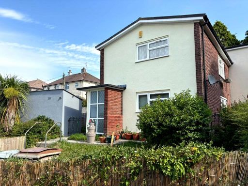 1 bedroom flat for sale in Shrewsbury Road, PLYMOUTH, PL5 — £110,000 • 1 bed • 1 bath • 453 ft²
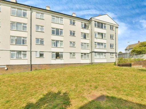 1 bedroom apartment for sale in Budshead Road, Plymouth, PL5 — £90,000 • 1 bed • 1 bath • 386 ft²
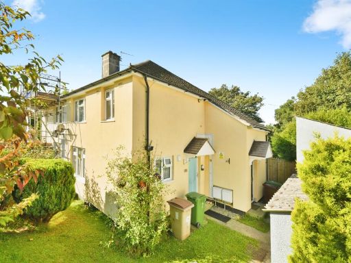 1 bedroom flat for sale in Tamerton Foliot Road, Plymouth, PL6 — £100,000 • 1 bed • 1 bath • 453 ft²
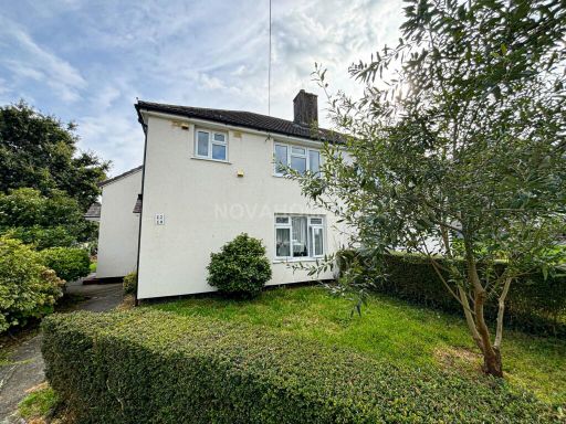 1 bedroom flat for sale in Ramillies Avenue, West Park, PL5 2NU, PL5 — £100,000 • 1 bed • 1 bath • 452 ft²
 1 bedroom flat for sale in Kinnaird Crescent, PLYMOUTH, Devon, PL6 — £90,000 • 1 bed • 1 bath
Meta
- {
"@context": "https://schema.org",
"@type": "Residence",
"name": "1 bedroom apartment for sale in Lancaster Gardens, Plymouth…",
"description": "",
"url": "https://propertypiper.co.uk/property/24520aac-9103-4103-b6da-54f9202f9734",
"image": "https://image-a.propertypiper.co.uk/2597a482-0fc3-4905-86b9-7220f0b1dc32-1024.jpeg",
"address": {
"@type": "PostalAddress",
"streetAddress": "WHITLEIGH METHODIST CHURCH, LANCASTER GARDENS",
"postalCode": "PL5 4AD",
"addressLocality": "Plymouth",
"addressRegion": "Plymouth, Moor View",
"addressCountry": "England"
},
"geo": {
"@type": "GeoCoordinates",
"latitude": 50.417062867526525,
"longitude": -4.143106542664805
},
"numberOfRooms": 1,
"numberOfBathroomsTotal": 1,
"floorSize": {
"@type": "QuantitativeValue",
"value": 513,
"unitCode": "FTK"
},
"offers": {
"@type": "Offer",
"price": 90000,
"priceCurrency": "GBP",
"availability": "https://schema.org/InStock"
},
"additionalProperty": [
{
"@type": "PropertyValue",
"name": "Feature",
"value": "semi-detached"
},
{
"@type": "PropertyValue",
"name": "Feature",
"value": "mid-20th century"
},
{
"@type": "PropertyValue",
"name": "Feature",
"value": "two-story"
},
{
"@type": "PropertyValue",
"name": "Feature",
"value": "garden"
},
{
"@type": "PropertyValue",
"name": "Feature",
"value": "access ramp"
},
{
"@type": "PropertyValue",
"name": "Feature",
"value": "parking potential"
},
{
"@type": "PropertyValue",
"name": "Feature",
"value": "external stairs"
},
{
"@type": "PropertyValue",
"name": "Feature",
"value": "dual-entrance"
},
{
"@type": "PropertyValue",
"name": "Feature",
"value": "rendered exterior"
},
{
"@type": "PropertyValue",
"name": "Feature",
"value": "living room"
},
{
"@type": "PropertyValue",
"name": "Feature",
"value": "mid-20th century"
},
{
"@type": "PropertyValue",
"name": "Feature",
"value": "fireplace"
},
{
"@type": "PropertyValue",
"name": "Feature",
"value": "laminate flooring"
},
{
"@type": "PropertyValue",
"name": "Feature",
"value": "window"
},
{
"@type": "PropertyValue",
"name": "Feature",
"value": "radiator"
},
{
"@type": "PropertyValue",
"name": "Feature",
"value": "cornicing"
},
{
"@type": "PropertyValue",
"name": "Feature",
"value": "outdated"
},
{
"@type": "PropertyValue",
"name": "Feature",
"value": "medium room"
}
]
}
High Res Floorplan Images
Compatible Floorplan Images
FloorplanImages Thumbnail