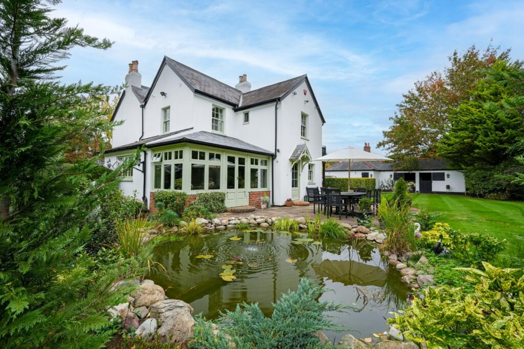
SG14 2PD - 4 bedroom detached house for sale in East End Green, Hertfo…
View on Property Piper
4 bedroom detached house for sale in East End Green, Hertford, SG14
Property Details
- Price: £1850000
- Bedrooms: 4
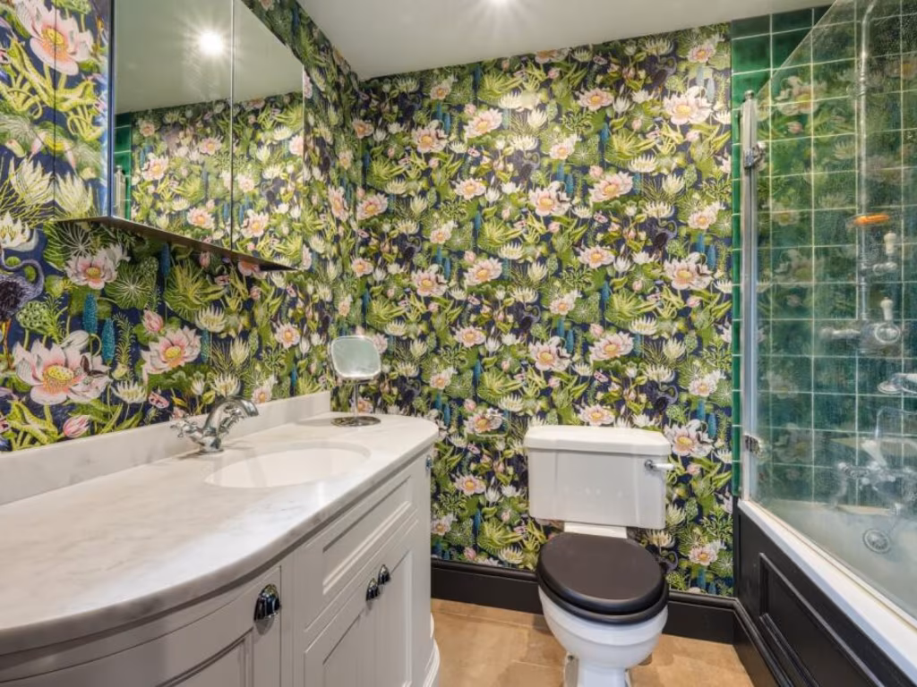
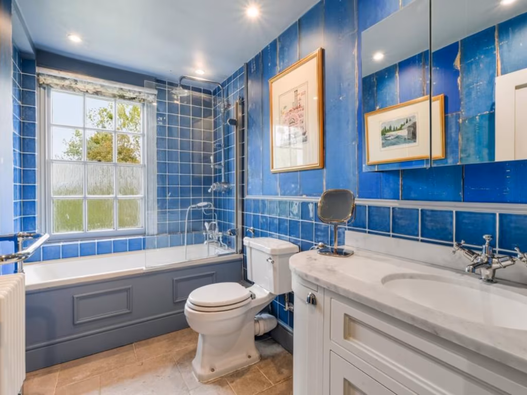
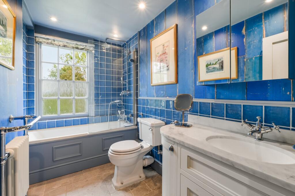
- Bathrooms: 2
- Property Type: undefined
- Property SubType: undefined
Image Descriptions
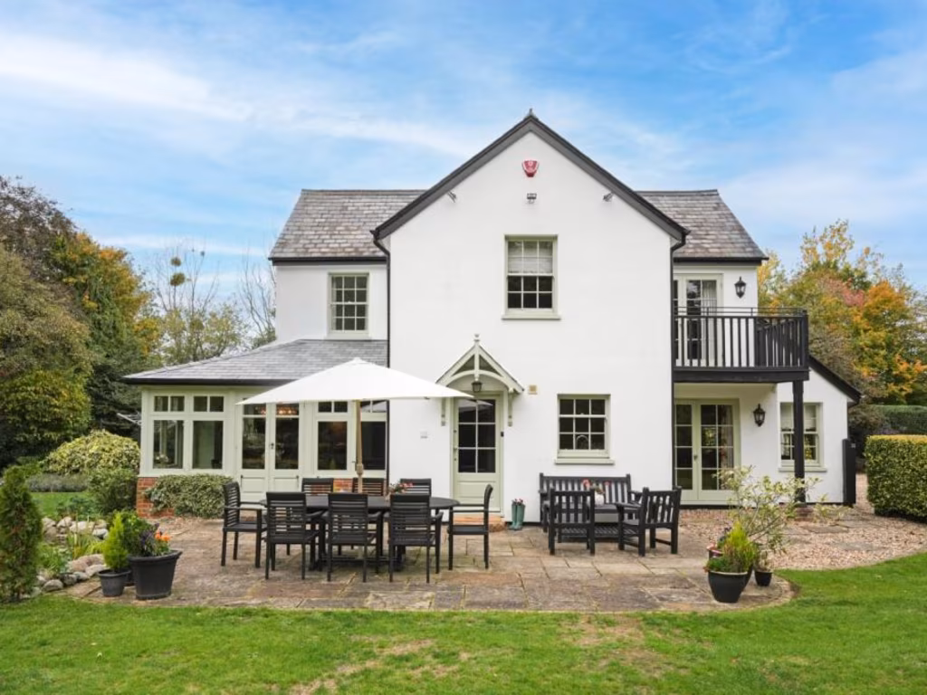
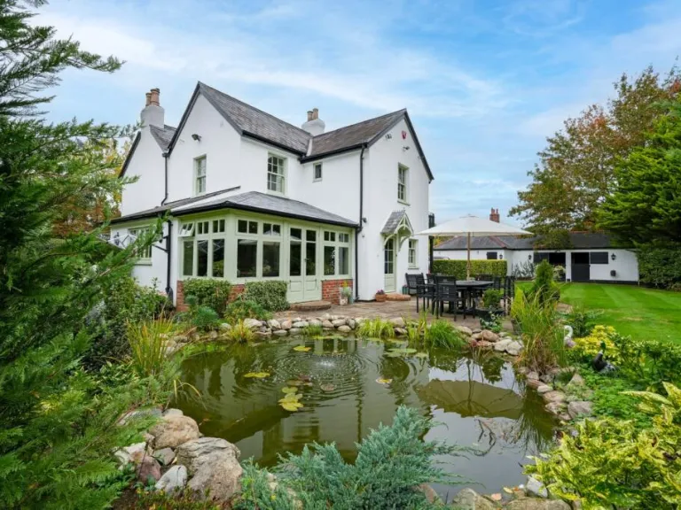
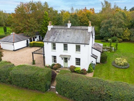
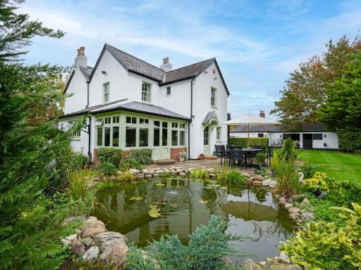
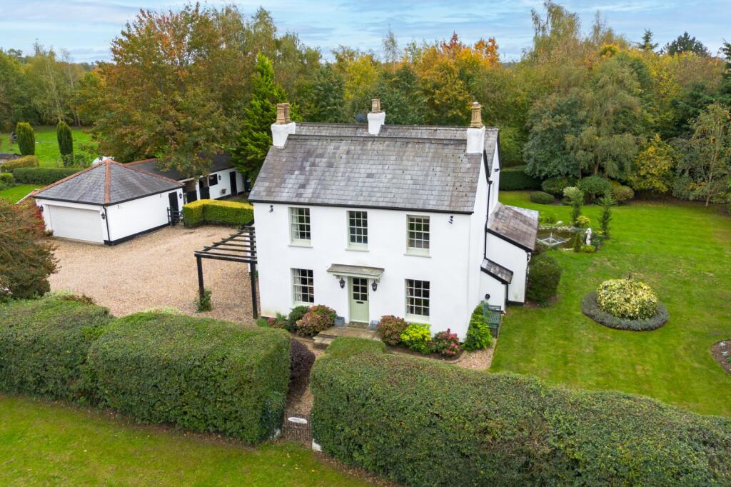
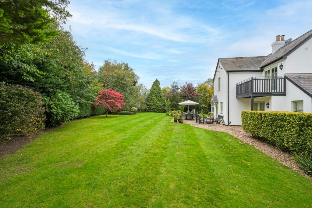
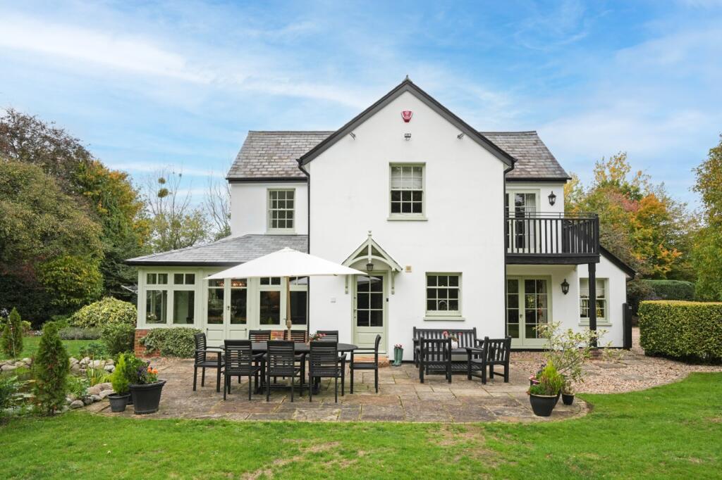
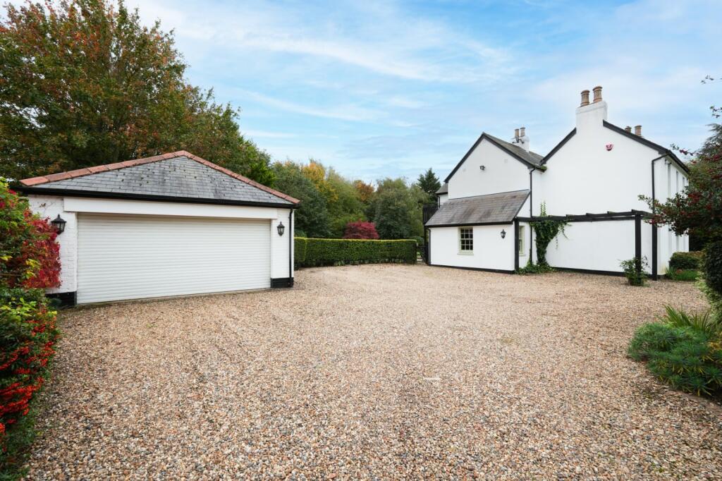
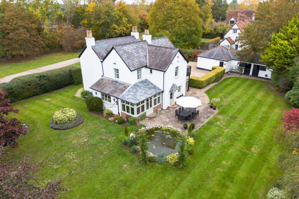
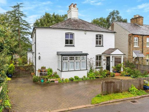
- detached house Georgian
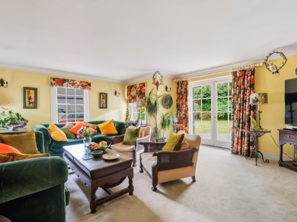
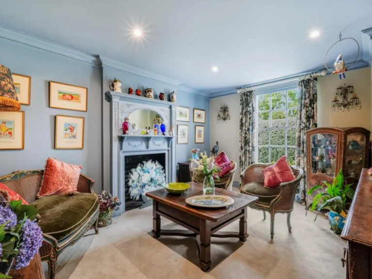
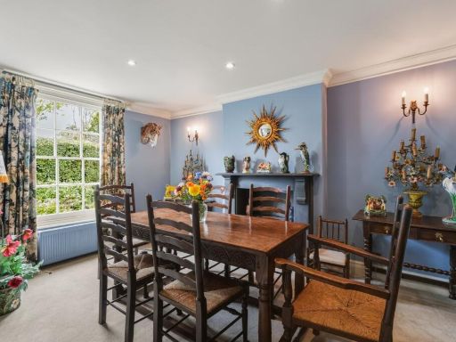
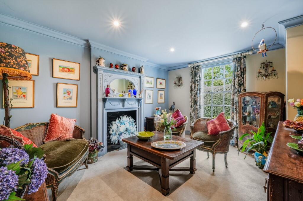
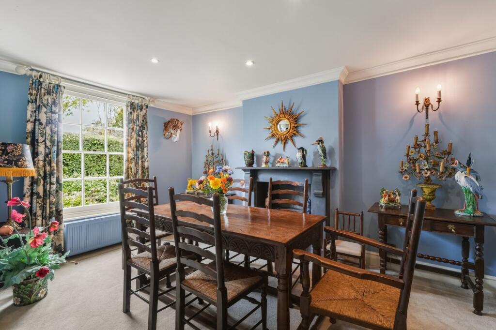
- living room Victorian
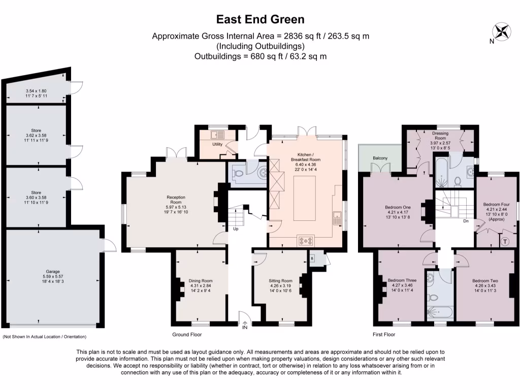
Floorplan Description
- Two-storey residential property with multiple reception rooms and four bedrooms
Rooms
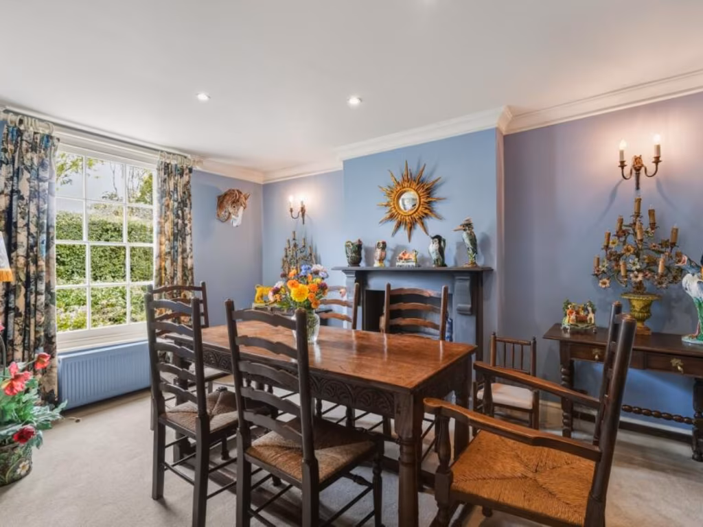
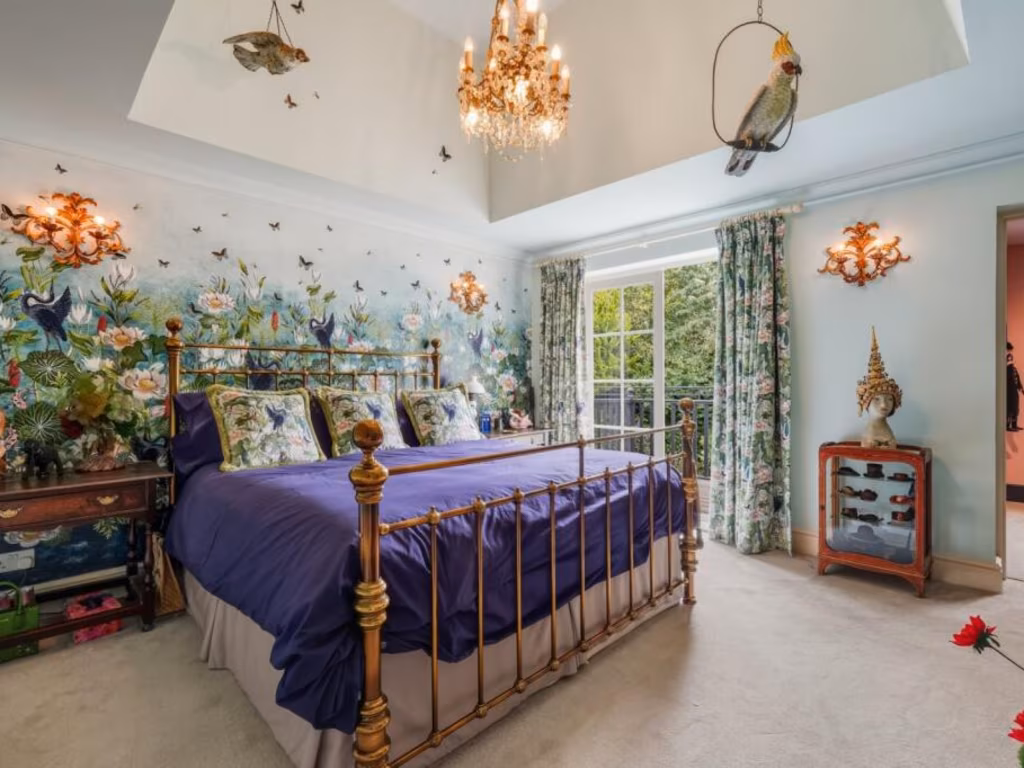
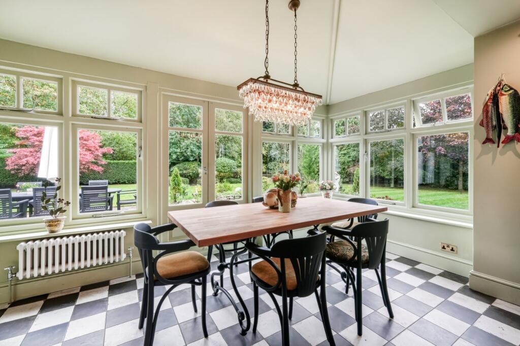
- Reception Room: large
- Dining Room: average
- Sitting Room: average
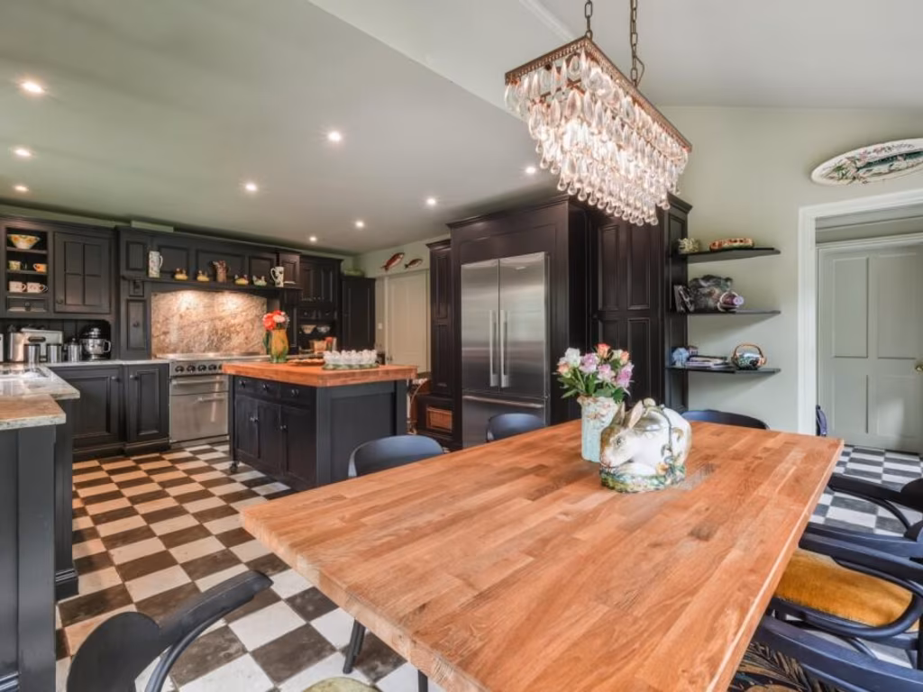
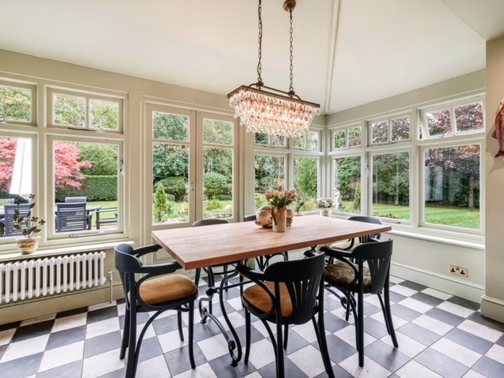
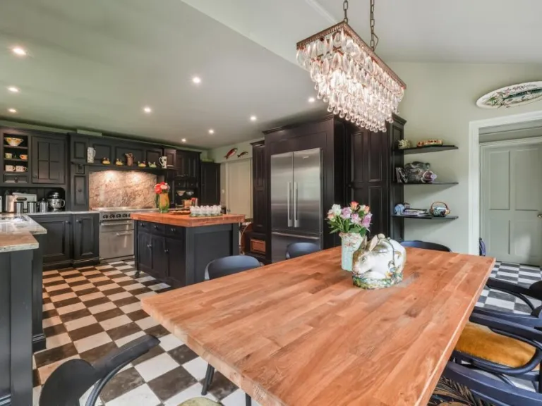
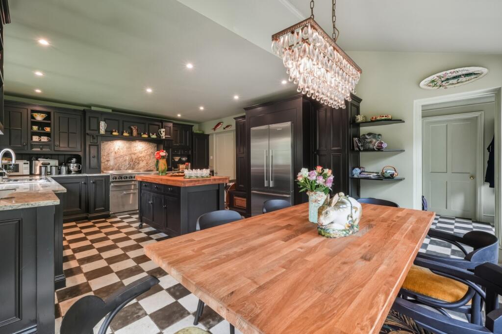
- Kitchen / Breakfast Room: large
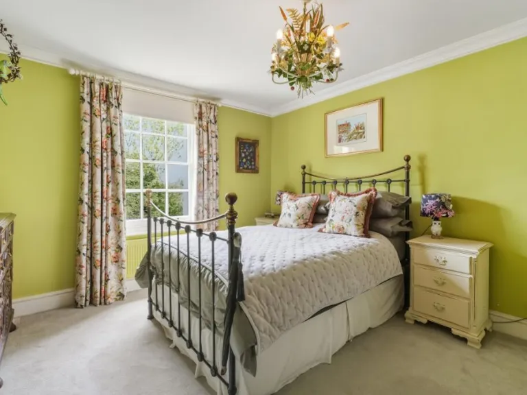
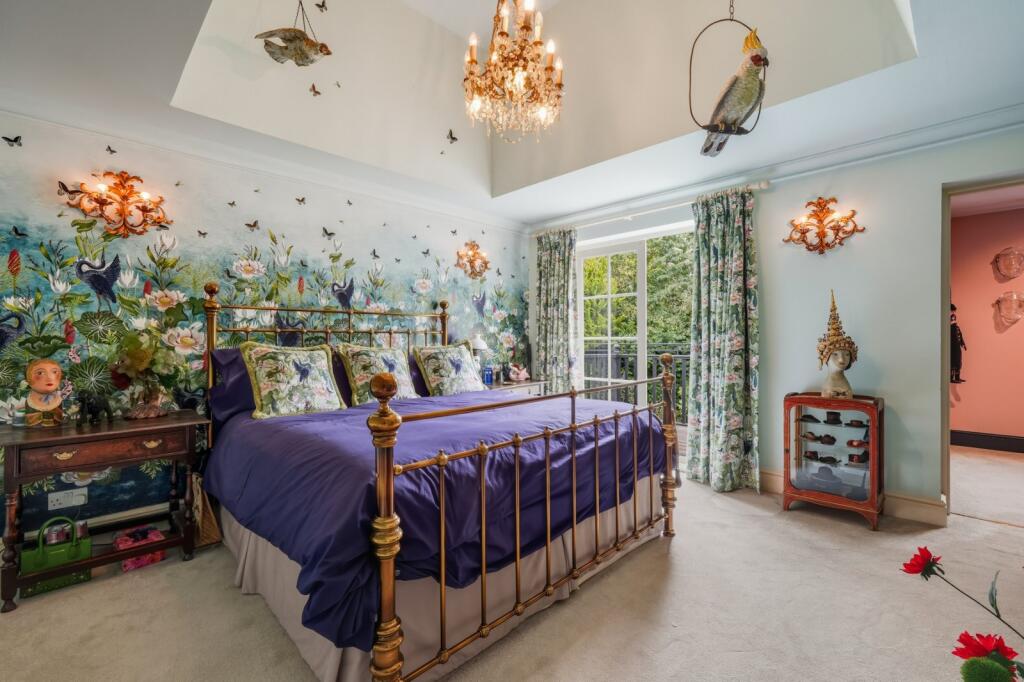
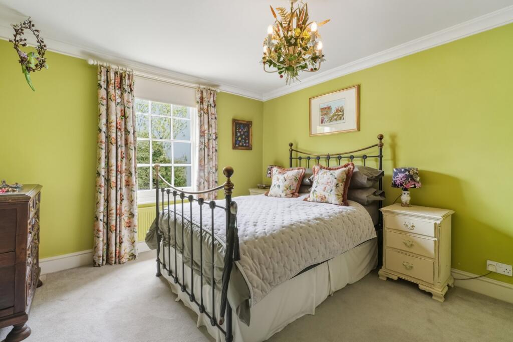
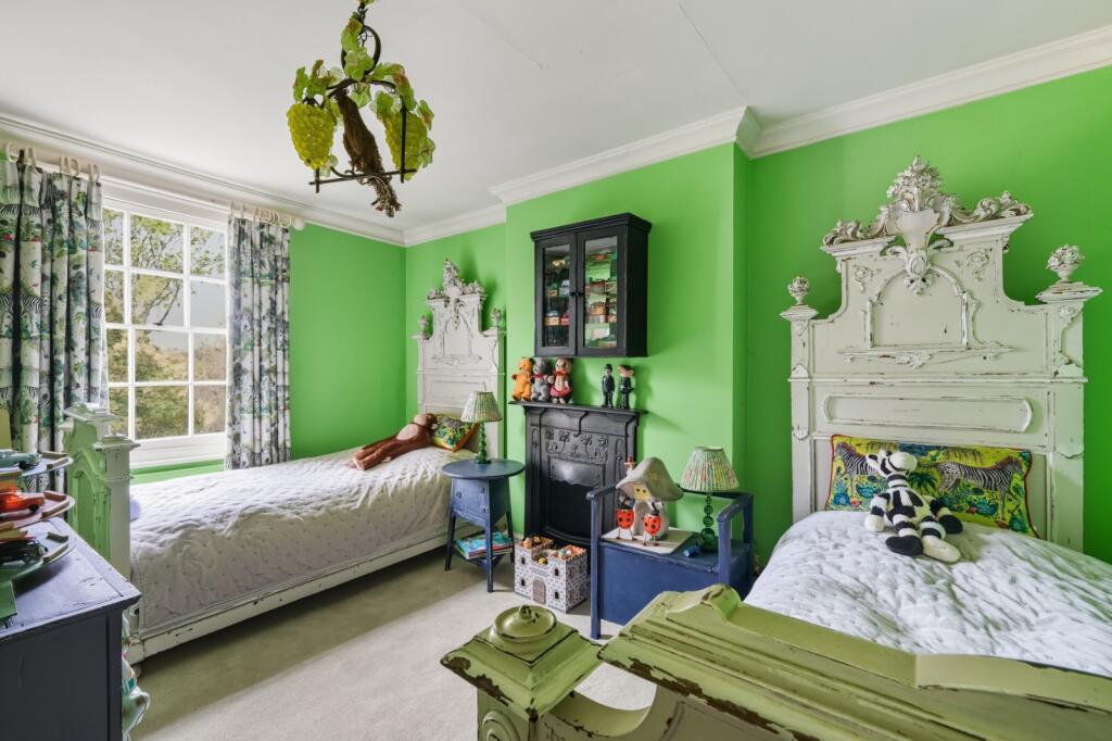
- Bedroom One: large
- Dressing Room: small
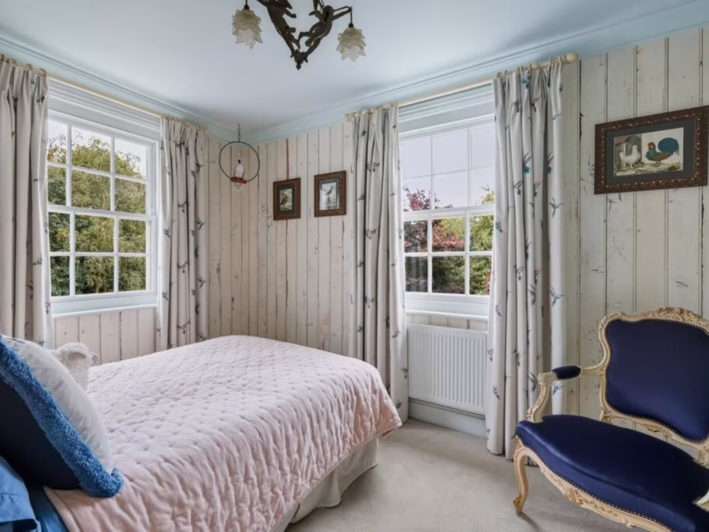
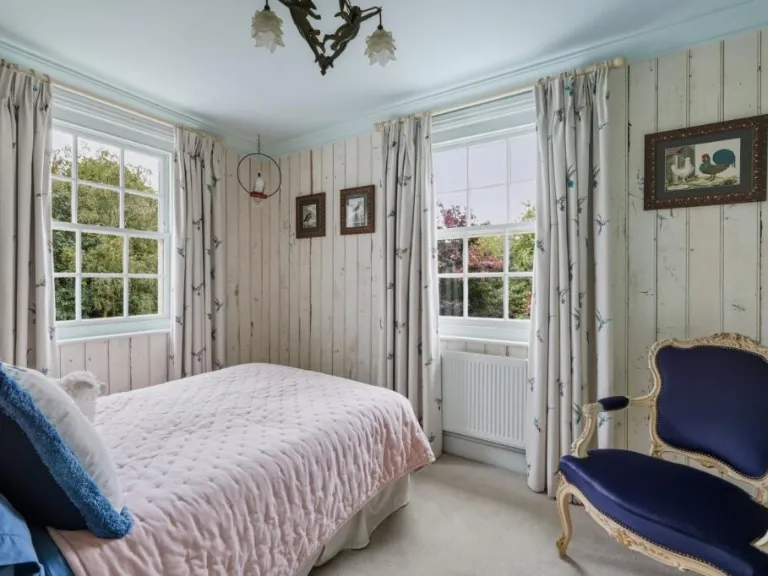
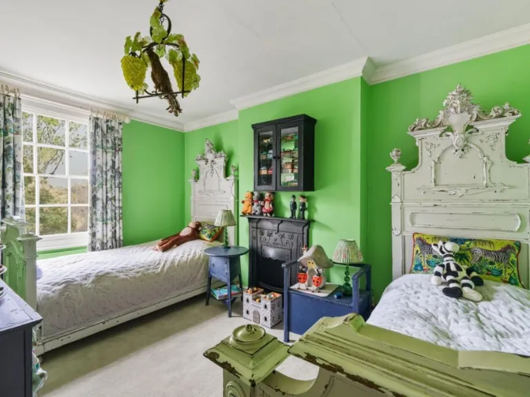
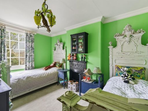
- Bedroom Four: small
- Bedroom Three: average
- Bedroom Two: average
Textual Property Features
Detected Visual Features
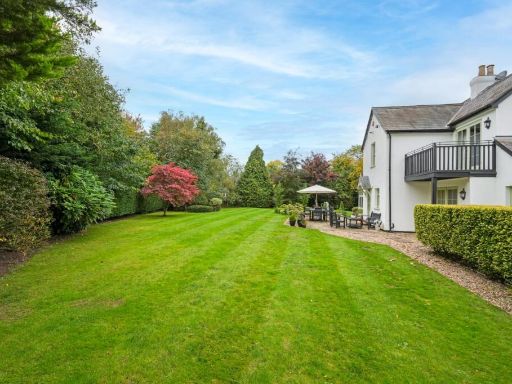
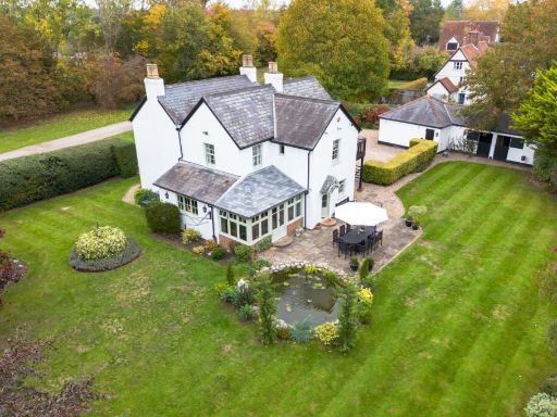
- Georgian
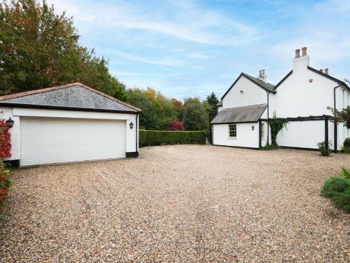
- detached house
- two-story
- white exterior
- pitched roof
- chimneys
- gravel driveway
- landscaped garden
- trees
- bushes
- Victorian
- living room
- fireplace
- traditional
- decorative moulding
- large window
- historic style
EPC Details
- Some double glazing
- Solid brick, as built, no insulation (assumed)
- Boiler and radiators, oil
- Low energy lighting in 53% of fixed outlets
- Solid, no insulation (assumed)
Nearby Schools
- Morgans Primary School & Nursery
- Hertingfordbury Cowper Primary School
- Holwell Primary School
- Mill Mead Primary School
- Hertford St Andrew CofE Primary School
- Panshanger Primary School
- Springmead Primary School
- Bengeo Primary School
- The Holy Family Catholic Primary School
- Stapleford Primary School
- Essendon CofE (VC) Primary School
- Simon Balle All-Through School
- The Sele School
- St Joseph's Catholic Primary School (Hertford)
- Tewin Cowper Church of England Voluntary Aided Primary School
- Commonswood Primary & Nursery School
- Richard Hale School
- Swallow Dell Primary and Nursery School
- Hollybush Primary School
- Watchlytes Primary School
- Ridgeway Academy
- St John's CofE Primary School
- Goffs Oak Primary & Nursery School
- Ponsbourne St Mary's Church of England Primary School
- Bayford Church of England Voluntary Controlled Primary School
- St Joseph's in the Park
- Abel Smith School
- Wheatcroft Primary School
- Duncombe School
- Waterside Academy
Nearest Bars And Restaurants
- Id: 1035875111
- Tags:
- Addr:
- City: Bayford
- Housenumber: 9
- Postcode: SG13 8PX
- Street: Ashendene Road
- Amenity: pub
- Brewery: mcmullen
- Building: yes
- Name: Baker Arms
- Website: https://bakerarmsbayford.co.uk/
- TagsNormalized:
- Lat: 51.759226
- Lon: -0.1025447
- FullGeoHash: gcpymwmr6e11
- PartitionGeoHash: gcpy
- Images:
- FoodStandards: null
- Distance: 2700.6
,- Id: 1588789629
- Tags:
- Addr:
- City: Hertford
- Housenumber: 22
- Postcode: SG14 2DJ
- Street: Fleming Crescent
- Amenity: fast_food
- Cuisine: fish_and_chips
- Drive_through: no
- Name: Carlys Fish and Chips
- Payment:
- American_express: no
- Cards: yes
- Cash: yes
- Contactless: yes
- Phone: +441992553380
- Takeaway: only
- TagsNormalized:
- fast food
- food
- fish
- takeaway
- Lat: 51.8002472
- Lon: -0.1013477
- FullGeoHash: gcpyttynq3vw
- PartitionGeoHash: gcpy
- Images:
- FoodStandards: null
- Distance: 2700.5
,- Id: 1588789653
- Tags:
- Amenity: pub
- Name: The Golden Griffen
- TagsNormalized:
- Lat: 51.7994132
- Lon: -0.1017791
- FullGeoHash: gcpyttvckqkp
- PartitionGeoHash: gcpy
- Images:
- FoodStandards: null
- Distance: 2606.9
,- Id: 105997650
- Tags:
- Amenity: pub
- Name: The Harts Horns
- TagsNormalized:
- Lat: 51.7864623
- Lon: -0.086624
- FullGeoHash: gcpyw52yj822
- PartitionGeoHash: gcpy
- Images:
- FoodStandards: null
- Distance: 2601.5
,- Id: 389147266
- Tags:
- Amenity: pub
- Name: Cowpers Arms
- TagsNormalized:
- Lat: 51.7841223
- Lon: -0.1394612
- FullGeoHash: gcpysg42qk41
- PartitionGeoHash: gcpy
- Images:
- FoodStandards: null
- Distance: 1225.7
}
Nearest General Shops
- Id: 2195783140
- Tags:
- TagsNormalized:
- Lat: 51.7962858
- Lon: -0.0963346
- FullGeoHash: gcpytv1z5prx
- PartitionGeoHash: gcpy
- Images:
- FoodStandards: null
- Distance: 2577.7
,- Id: 7093441543
- Tags:
- Name: Gilly’s Pet Supplies
- Shop: pet
- TagsNormalized:
- Lat: 51.7878645
- Lon: -0.1482493
- FullGeoHash: gcpysesn1t9k
- PartitionGeoHash: gcpy
- Images:
- FoodStandards: null
- Distance: 1948.8
,- Id: 280420833
- Tags:
- Name: Rochfords nursery
- Shop: garden_centre
- TagsNormalized:
- Lat: 51.7805981
- Lon: -0.1322516
- FullGeoHash: gcpysfrey745
- PartitionGeoHash: gcpy
- Images:
- FoodStandards: null
- Distance: 643.2
}
Nearest Grocery shops
- Id: 896200811
- Tags:
- Level: 0
- Name: Hertford Wines
- Note: Despite the name it seems to be more of a convenience store selling groceries, fruit and veg as well as alcohol
- Payzone: yes
- Shop: convenience
- TagsNormalized:
- Lat: 51.795826
- Lon: -0.0781914
- FullGeoHash: gcpywjphd1b3
- PartitionGeoHash: gcpy
- Images:
- FoodStandards: null
- Distance: 3548.1
,- Id: 907046868
- Tags:
- Building: retail
- Building:colour: white
- Building:levels: 3
- Name: Castle Food & Wine
- Roof:
- Colour: grey
- Levels: 1
- Material: slate
- Orientation: along
- Shape: gambrel
- Shop: convenience
- TagsNormalized:
- retail
- food
- wine
- convenience
- shop
- Lat: 51.796529
- Lon: -0.079192
- FullGeoHash: gcpywjq2dsy4
- PartitionGeoHash: gcpy
- Images:
- FoodStandards: null
- Distance: 3528.7
,- Id: 367479457
- Tags:
- Addr:
- City: Hertford
- Housenumber: 133
- Postcode: SG14 1NL
- Street: Hertingfordbury Road
- Brand: Londis
- Brand:wikidata: Q21008564
- Building: yes
- Name: Londis
- Operator: Londis
- Shop: convenience
- TagsNormalized:
- Lat: 51.795003
- Lon: -0.089523
- FullGeoHash: gcpytuyzcbqg
- PartitionGeoHash: gcpy
- Images:
- FoodStandards: null
- Distance: 2843
}
Nearest Religious buildings
- Id: 404371208
- Tags:
- Addr:
- City: Hertford
- County: Hertfordshire
- Housename: Bayford (C of E) Primary School
- Postcode: SG13 8PX
- Street: Ashendene Road
- Suburb: Bayford
- Amenity: school
- Denomination: anglican
- Email: admin@bayford.herts.sch.uk
- Fax: +44 1992 511 633
- Name: Bayford Church of England Voluntary Controlled Primary School
- Old_name: Bayford SE Primary School
- Phone: +44 1992 511 259
- Ref:
- Religion: christian
- Source: OS OpenData StreetView;Bing
- Website: http://www.bayford.herts.sch.uk/
- TagsNormalized:
- school
- anglican
- church
- christian
- Lat: 51.7586565
- Lon: -0.1055798
- FullGeoHash: gcpymw7h5bcu
- PartitionGeoHash: gcpy
- Images:
- FoodStandards: null
- Distance: 2654.5
,- Id: 763173126
- Tags:
- Amenity: place_of_worship
- Building: church
- Denomination: anglican
- Name: St Mary
- Religion: christian
- Wikidata: Q17553626
- TagsNormalized:
- place of worship
- church
- anglican
- christian
- Lat: 51.7629263
- Lon: -0.1035543
- FullGeoHash: gcpymxhsghb6
- PartitionGeoHash: gcpy
- Images:
- FoodStandards: null
- Distance: 2318.2
,- Id: 415875964
- Tags:
- Addr:
- City: Hertford
- Housename: St Mary's Church Hertingfordbury
- Postcode: SG14 2LE
- Street: St Mary's Lane
- Suburb: Hertingfordbury
- Air_conditioning: no
- Amenity: place_of_worship
- Building: church
- Denomination: anglican
- Name: St Mary's Church Hertingfordbury
- Nohousenumber: yes
- Religion: christian
- Website: https://www.hertingfordburystmary.org/
- Wheelchair: yes
- Wikidata: Q17554076
- TagsNormalized:
- place of worship
- church
- anglican
- christian
- Lat: 51.7909016
- Lon: -0.1041355
- FullGeoHash: gcpytshpv7yc
- PartitionGeoHash: gcpy
- Images:
- FoodStandards: null
- Distance: 1775.9
}
Nearest Medical buildings
- Id: 402947663
- Tags:
- Amenity: doctors
- Name: Hanscombe House
- TagsNormalized:
- Lat: 51.7966398
- Lon: -0.0836199
- FullGeoHash: gcpywj71792r
- PartitionGeoHash: gcpy
- Images:
- FoodStandards: null
- Distance: 3279.7
,- Id: 992922367
- Tags:
- Addr:
- Postcode: SG14 1LP
- Street: North Road
- Amenity: hospital
- Emergency: no
- Healthcare: hospital
- Name: Hertford County Hospital
- Operator: East and North Hertfordshire NHS Trust
- Phone: +44 1438 314333
- Website: https://www.enherts-tr.nhs.uk/hospitals/hertford/
- Wikidata: Q5744684
- TagsNormalized:
- Lat: 51.7965533
- Lon: -0.0887462
- FullGeoHash: gcpytvr2u165
- PartitionGeoHash: gcpy
- Images:
- FoodStandards: null
- Distance: 2989.5
,- Id: 1588789651
- Tags:
- Addr:
- City: Hertford
- Housenumber: 2
- Postcode: SG14 2DJ
- Street: Fleming Crescent
- Amenity: pharmacy
- Dispensing: yes
- Drive_through: no
- Healthcare: pharmacy
- Name: Crescent Pharmacy
- Payment:
- Cash: yes
- Credit_cards: yes
- Debit_cards: yes
- Mastercard: yes
- Visa: yes
- Phone: +441992534299
- Website: http://www.crescentchemist.co.uk/
- TagsNormalized:
- Lat: 51.8000372
- Lon: -0.1011852
- FullGeoHash: gcpyttym44yc
- PartitionGeoHash: gcpy
- Images:
- FoodStandards: null
- Distance: 2687.3
,- Id: 1588789646
- Tags:
- Addr:
- Amenity: doctors
- Healthcare: doctor
- Healthcare:speciality: general
- Name: Wallance House Branch Surgery
- TagsNormalized:
- doctor
- doctors
- health
- healthcare
- general
- surgery
- Lat: 51.799883
- Lon: -0.1021601
- FullGeoHash: gcpyttvs5qpf
- PartitionGeoHash: gcpy
- Images:
- FoodStandards: null
- Distance: 2636.1
}
Nearest Airports
- Id: 495488524
- Tags:
- Aerodrome: international
- Aerodrome:type: public
- Aeroway: aerodrome
- Alt_name: Stansted
- Iata: STN
- Icao: EGSS
- Is_in: Essex,England,UK
- Name: London Stansted Airport
- Ref: STN
- Source: Gagravarr_Airports
- Website: https://www.stanstedairport.com/
- Wikidata: Q8709
- Wikipedia: en:London Stansted Airport
- TagsNormalized:
- airport
- international airport
- Lat: 51.8869677
- Lon: 0.2429264
- FullGeoHash: u10pjt8zkxg4
- PartitionGeoHash: u10p
- Images:
- FoodStandards: null
- Distance: 27813.9
,- Id: 110273499
- Tags:
- Addr:
- Country: GB
- Postcode: LU2 9LY
- Aerodrome: international
- Aerodrome:type: public
- Aeroway: aerodrome
- Alt_name: London Luton
- Iata: LTN
- Icao: EGGW
- Name: London Luton Airport
- Website: https://www.london-luton.co.uk/
- Wikidata: Q8712
- Wikipedia: en:Luton Airport
- TagsNormalized:
- airport
- international airport
- Lat: 51.8780363
- Lon: -0.3701408
- FullGeoHash: gcpxps47rngh
- PartitionGeoHash: gcpx
- Images:
- FoodStandards: null
- Distance: 20185.3
,- Id: 121158889
- Tags:
- Aerodrome: continental
- Aeroway: aerodrome
- Fhrs:
- Authority: City of London Corporation
- Iata: LCY
- Icao: EGLC
- Name: London City Airport
- Operator: London City Airport Limited
- Ref: LCY
- Website: https://www.londoncityairport.com/
- Wikidata: Q8982
- Wikipedia: en:London City Airport
- TagsNormalized:
- airport
- continental airport
- Lat: 51.5042658
- Lon: 0.0539987
- FullGeoHash: u10j10p64702
- PartitionGeoHash: u10j
- Images:
- FoodStandards: null
- Distance: 32999.1
}
Nearest Leisure Facilities
- Id: 952357374
- Tags:
- Leisure: pitch
- Sport: equestrian
- TagsNormalized:
- pitch
- leisure
- equestrian
- sports
- Lat: 51.7900487
- Lon: -0.1153631
- FullGeoHash: gcpytk5fzug4
- PartitionGeoHash: gcpy
- Images:
- FoodStandards: null
- Distance: 1236.5
,- Id: 747416151
- Tags:
- Access: private
- Covered: no
- Leisure: pitch
- Surface: asphalt
- TagsNormalized:
- Lat: 51.7893376
- Lon: -0.1271964
- FullGeoHash: gcpyt5gqu072
- PartitionGeoHash: gcpy
- Images:
- FoodStandards: null
- Distance: 1081.7
,- Id: 952357387
- Tags:
- Access: customers
- Leisure: swimming_pool
- Location: indoor
- Swimming_pool: children's_pool
- TagsNormalized:
- swimming
- swimming pool
- pool
- leisure
- Lat: 51.7892079
- Lon: -0.1274233
- FullGeoHash: gcpyt5gnnb46
- PartitionGeoHash: gcpy
- Images:
- FoodStandards: null
- Distance: 1072.2
,- Id: 1147474328
- Tags:
- Leisure: pitch
- Sport: tennis
- TagsNormalized:
- Lat: 51.7808378
- Lon: -0.1381593
- FullGeoHash: gcpysf7mhxuc
- PartitionGeoHash: gcpy
- Images:
- FoodStandards: null
- Distance: 1050.3
,- Id: 952357388
- Tags:
- Access: customers
- Leisure: pitch
- Lit: no
- Surface: grass
- TagsNormalized:
- Lat: 51.7890661
- Lon: -0.1265844
- FullGeoHash: gcpyt5gv4meu
- PartitionGeoHash: gcpy
- Images:
- FoodStandards: null
- Distance: 1041.8
}
Nearest Tourist attractions
- Id: 901806329
- Tags:
- Addr:
- City: Hertford
- Housenumber: 14
- Postcode: SG14 1DT
- Street: Bull Plain
- Building: yes
- Level: 0
- Name: Brothership
- Tourism: gallery
- Website: https://brothershipstudio.com
- TagsNormalized:
- Lat: 51.797026
- Lon: -0.0777658
- FullGeoHash: gcpywjr7ecmx
- PartitionGeoHash: gcpy
- Images:
- FoodStandards: null
- Distance: 3641.2
,- Id: 4223125289
- Tags:
- Addr:
- Description: Only for staffs of Malaysia Rubber Board
- Email: general@tarrc.co.uk
- Internet_access: wlan
- Name: Hale Court
- Operator: Tun Abdul Razak Research Centre
- Tourism: hostel
- TagsNormalized:
- Lat: 51.7942386
- Lon: -0.077182
- FullGeoHash: gcpywhzg39bg
- PartitionGeoHash: gcpy
- Images:
- FoodStandards: null
- Distance: 3525.7
,- Id: 2195819330
- Tags:
- Name: Apple Tree B&B
- Tourism: guest_house
- TagsNormalized:
- Lat: 51.7964915
- Lon: -0.0947038
- FullGeoHash: gcpytv703jze
- PartitionGeoHash: gcpy
- Images:
- FoodStandards: null
- Distance: 2674.2
}
Nearest Hotels
- Id: 896166292
- Tags:
- Addr:
- City: Hertford
- Country: GB
- Postcode: SG14 1BZ
- Street: Fore Street
- Bar: yes
- Building: yes
- Building:colour: white
- Building:levels: 3
- Email: reception@salisburyarms.co.uk
- Fax: +44 1992 552510
- Name: Salisbury Arms Hotel
- Operator:
- Phone: +44 1992 583091
- Reservation: yes
- Roof:
- Rooms: 35
- Smoking: no
- Tourism: hotel
- Website: https://www.salisburyarmshotel.co.uk/
- Wheelchair: yes
- Wikidata: Q17554133
- Wikimedia_commons: Category:Salisbury_Arms_Hotel,_Hertford
- TagsNormalized:
- Lat: 51.7959599
- Lon: -0.0775562
- FullGeoHash: gcpywjpt2f9z
- PartitionGeoHash: gcpy
- Images:
- FoodStandards: null
- Distance: 3593.5
,- Id: 27397339
- Tags:
- Name: Baker Arms
- Tourism: hotel
- Website: https://bakerarmsbayford.co.uk/
- Wheelchair: limited
- TagsNormalized:
- Lat: 51.7592611
- Lon: -0.1025399
- FullGeoHash: gcpymwmrd9se
- PartitionGeoHash: gcpy
- Images:
- FoodStandards: null
- Distance: 2697.4
,- Id: 357460682
- Tags:
- Addr:
- City: Hertford
- Housenumber: 234
- Postcode: SG14 2LB
- Street: Hertingfordbury Road
- Air_conditioning: yes
- Bar: yes
- Building:
- Description: In country inn dating from the 15th-century, this pub with guest rooms is in the quiet village of Hertingfordbury, 1.4 miles from Hertford and 6.1 miles from the A1M motorway at Hatfield.
- Email: info@whitehorsehertingfordbury.co.uk
- Internet_access: wlan
- Internet_access:fee: customers
- Name: The White Horse
- Payment:
- American_express: yes
- Cash: yes
- Contactless: yes
- Mastercard: yes
- Visa: yes
- Phone: +441992586791
- Reservation: yes
- Rooms: 7
- Smoking: outside
- Tourism: hotel
- Website: https://www.whitehorsehertingfordbury.co.uk/
- Wikidata: Q26559162
- TagsNormalized:
- Lat: 51.7916983
- Lon: -0.1066177
- FullGeoHash: gcpyts6ke8k4
- PartitionGeoHash: gcpy
- Images:
- FoodStandards: null
- Distance: 1721.6
}
Tags
- Georgian
- detached house
- two-story
- white exterior
- pitched roof
- chimneys
- gravel driveway
- landscaped garden
- trees
- bushes
- Victorian
- living room
- fireplace
- traditional
- decorative moulding
- large window
- historic style
Local Market Stats
- Average Price/sqft: £503
- Avg Income: £57000
- Rental Yield: 3.6%
- Social Housing: 12%
- Planning Success Rate: 9%
Similar Properties
 5 bedroom detached house for sale in 'White Cottage' Hertford Heath, Hertford, SG13 — £1,125,000 • 5 bed • 1 bath • 2237 ft²
 5 bedroom semi-detached house for sale in Ponsbourne Park, Newgate Street, Hertford, SG13 — £925,000 • 5 bed • 2 bath • 1103 ft²
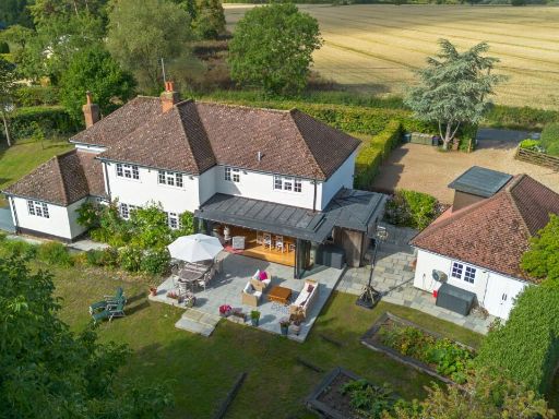 5 bedroom detached house for sale in Perry Green, Much Hadham, Hertfordshire, SG10 — £1,500,000 • 5 bed • 4 bath • 3000 ft²
 3 bedroom detached house for sale in St. Marys Lane, Hertingfordbury, Hertford, SG14 — £1,250,000 • 3 bed • 2 bath • 2016 ft²
 4 bedroom detached house for sale in Lower Road, Breachwood Green, Hitchin, Hertfordshire, SG4 — £850,000 • 4 bed • 3 bath • 2100 ft²
 5 bedroom detached house for sale in Dassels, Braughing, SG11 — £1,299,950 • 5 bed • 2 bath • 2801 ft²
Meta
- {
"@context": "https://schema.org",
"@type": "Residence",
"name": "4 bedroom detached house for sale in East End Green, Hertfo…",
"description": "",
"url": "https://propertypiper.co.uk/property/1f7cd706-9739-4533-ac36-a4130bda4d8b",
"image": "https://image-a.propertypiper.co.uk/09bb1e4b-947c-449a-bb46-f4c480c4829d-1024.jpeg",
"address": {
"@type": "PostalAddress",
"streetAddress": "WHITE COTTAGE EAST END GREEN HERTFORD",
"postalCode": "SG14 2PD",
"addressLocality": "East Hertfordshire",
"addressRegion": "North East Hertfordshire",
"addressCountry": "England"
},
"geo": {
"@type": "GeoCoordinates",
"latitude": 51.77996969454599,
"longitude": -0.12295666278864491
},
"numberOfRooms": 4,
"numberOfBathroomsTotal": 2,
"floorSize": {
"@type": "QuantitativeValue",
"value": 2836,
"unitCode": "FTK"
},
"offers": {
"@type": "Offer",
"price": 1850000,
"priceCurrency": "GBP",
"availability": "https://schema.org/InStock"
},
"additionalProperty": [
{
"@type": "PropertyValue",
"name": "Feature",
"value": "Georgian"
},
{
"@type": "PropertyValue",
"name": "Feature",
"value": "detached house"
},
{
"@type": "PropertyValue",
"name": "Feature",
"value": "two-story"
},
{
"@type": "PropertyValue",
"name": "Feature",
"value": "white exterior"
},
{
"@type": "PropertyValue",
"name": "Feature",
"value": "pitched roof"
},
{
"@type": "PropertyValue",
"name": "Feature",
"value": "chimneys"
},
{
"@type": "PropertyValue",
"name": "Feature",
"value": "gravel driveway"
},
{
"@type": "PropertyValue",
"name": "Feature",
"value": "landscaped garden"
},
{
"@type": "PropertyValue",
"name": "Feature",
"value": "trees"
},
{
"@type": "PropertyValue",
"name": "Feature",
"value": "bushes"
},
{
"@type": "PropertyValue",
"name": "Feature",
"value": "Victorian"
},
{
"@type": "PropertyValue",
"name": "Feature",
"value": "living room"
},
{
"@type": "PropertyValue",
"name": "Feature",
"value": "fireplace"
},
{
"@type": "PropertyValue",
"name": "Feature",
"value": "traditional"
},
{
"@type": "PropertyValue",
"name": "Feature",
"value": "decorative moulding"
},
{
"@type": "PropertyValue",
"name": "Feature",
"value": "large window"
},
{
"@type": "PropertyValue",
"name": "Feature",
"value": "historic style"
}
]
}
High Res Floorplan Images
Compatible Floorplan Images
FloorplanImages Thumbnail